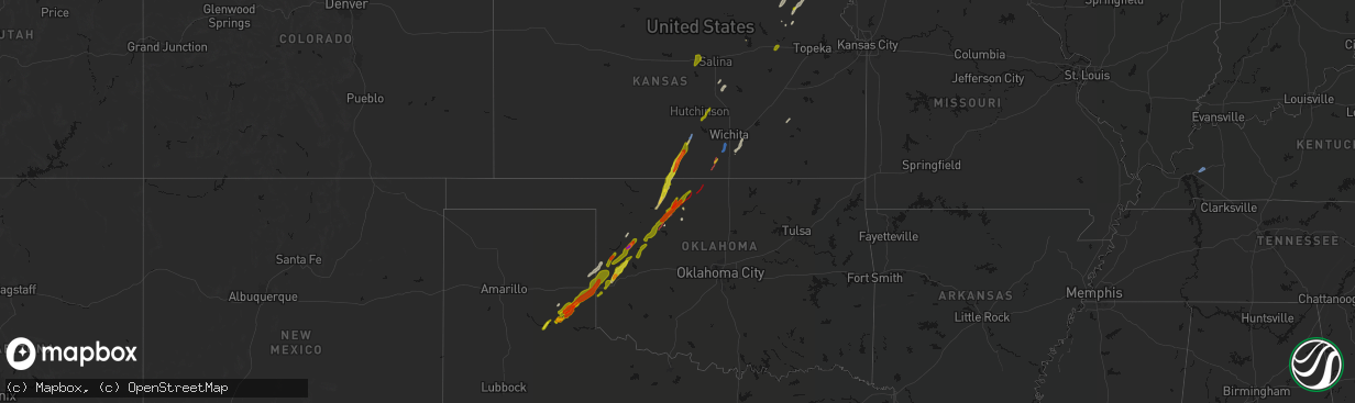
Hail Map on March 5, 2026
The weather event on March 5, 2026 includes Wind, Hail, and Tornado maps. 9 states and 283 cities were impacted and suffered possible damage. The total estimated number of properties impacted is 10,231.
Wind
Hail
Tornado
10,231
Estimated number of impacted properties by a 1.00" hail or larger2,483
Estimated number of impacted properties by a 1.75" hail or larger0
Estimated number of impacted properties by a 2.50" hail or largerStates Impacted by Hail Map on March 5, 2026
Storm reports
Kansas
| Date | Description |
|---|---|
| 03/05/202612:37 AM CST | Report from personal weather station. |
| 03/05/202612:11 AM CST | Rope tornado. |
| 03/05/202612:02 AM CST | A local report indicates a tornado near 3 WSW Mayfield |
| 03/04/202611:59 PM CST | Cone tornado reported. |
| 03/04/202611:50 PM CST | Tornado reported on the ground near 80th and south bluff road. |
| 03/04/202611:47 PM CST | A local report indicates a tornado near 8 S Milan |
| 03/04/202610:34 PM CST | Mostly nickel hail with a couple quarter size. |
| 03/04/20269:04 PM CST | A local report indicates 1.00 inch wind near Spivey |
| 03/04/20268:55 PM CST | Relayed from emergency management. |
| 03/04/20268:43 PM CST | Social media photo. |
| 03/04/20268:30 PM CST | Social media photo. |
Kentucky
| Date | Description |
|---|---|
| 03/05/20266:12 AM CST | Part |
West Virginia
| Date | Description |
|---|---|
| 03/05/20264:27 PM CST | Trees blew down in the 2100 block of cr-7 south fork road. |
Oklahoma
| Date | Description |
|---|---|
| 03/05/202612:10 AM CST | Semi blown over by wind. Time estimated by radar. |
| 03/05/202612:00 AM CST | Time estimated from radar. |
| 03/04/202611:15 PM CST | A local report indicates 1.00 inch wind near 2 SE Strong City |
| 03/04/202610:22 PM CST | Damage report. Power lines and trees down. Structure damage noted at 860 and harper road. |
| 03/04/202610:20 PM CST | Radar detected tornado debris signature. |
| 03/04/20269:42 PM CST | Radar detected tds and broadcast media video. |
| 03/04/20269:18 PM CST | A local report indicates 1.25 inch wind near Hammon |
| 03/04/20269:15 PM CST | Radar detected tds. |
| 03/04/20268:13 PM CST | A local report indicates 1.75 inch wind near 5 N Cheyenne |
| 03/04/20267:37 PM CST | A local report indicates 1.00 inch wind near 9 SSW Erick |
| 03/04/20267:33 PM CST | Via social media. |
Texas
| Date | Description |
|---|---|
| 03/04/20269:00 PM CST | Storm chaser reported tornado looking west of quail. |
| 03/04/20267:56 PM CST | A local report indicates 1.75 inch wind near 10 SE Hedley |
| 03/04/20267:51 PM CST | Report from mping: quarter |
| 03/04/20267:50 PM CST | Relayed by broadcast media. Time estimated from radar. |
| 03/04/20267:35 PM CST | Report from mping: hen egg+ |
| 03/04/20267:30 PM CST | Report from mping: hen egg |
| 03/04/20267:27 PM CST | Time estimated from radar. |
| 03/04/20267:21 PM CST | Report from mping: half dollar |
| 03/04/20267:20 PM CST | Report from mping: half dollar |
| 03/04/20266:15 PM CST | Public reported penny to quarter size hail. Time estimated by radar. |
Cities Impacted by Hail Map on March 5, 2026
- Myakka City, FL
- Wimauma, FL
- Parrish, FL
- Arcadia, FL
- Lithia, FL
- Plant City, FL
- Crane, TX
- Moorefield, WV
- Mathias, WV
- Baker, WV
- North Port, FL
- Bowling Green, FL
- Ona, FL
- Punta Gorda, FL
- Webster, FL
- Brownwood, TX
- Bangs, TX
- Quitaque, TX
- Butler, OK
- Custer City, OK
- Taloga, OK
- Leedey, OK
- Galva, KS
- Gypsum, KS
- Del Rio, TX
- Lakeview, TX
- Memphis, TX
- Comstock, TX
- Putnam, OK
- Hutchinson, KS
- Burrton, KS
- Haven, KS
- Wellington, TX
- Erick, OK
- Seiling, OK
- Hollis, OK
- Texola, OK
- Hedley, TX
- Clarendon, TX
- Chester, OK
- Fairview, OK
- Aline, OK
- Waynoka, OK
- Canton, KS
- Sayre, OK
- Sweetwater, OK
- Cheyenne, OK
- Abilene, KS
- Chapman, KS
- Quail, TX
- Enterprise, KS
- Alva, OK
- Dacoma, OK
- Wakefield, KS
- Junction City, KS
- Burdick, KS
- Carmen, OK
- Burlington, OK
- Kiowa, KS
- Milford, KS
- Cherokee, OK
- Wilsey, KS
- Lelia Lake, TX
- Council Grove, KS
- Herington, KS
- Elk City, OK
- Cleo Springs, OK
- Riley, KS
- Alma, KS
- Alta Vista, KS
- Medicine Lodge, KS
- Hazelton, KS
- Rocksprings, TX
- Longford, KS
- Solomon, KS
- Leonardville, KS
- Dwight, KS
- Manhattan, KS
- Attica, KS
- Sharon, KS
- Wamego, KS
- Saint George, KS
- Randolph, KS
- Olsburg, KS
- Helena, OK
- Ringwood, OK
- Clay Center, KS
- Corning, KS
- Goff, KS
- Kingman, KS
- Mayetta, KS
- Denison, KS
- Hoyt, KS
- Blue Rapids, KS
- Hammon, OK
- Spivey, KS
- Zenda, KS
- Westmoreland, KS
- Pretty Prairie, KS
- Valley Falls, KS
- Holton, KS
- Muscotah, KS
- Effingham, KS
- Jet, OK
- Goltry, OK
- Shamrock, TX
- Mclean, TX
- Meno, OK
- Havensville, KS
- Marysville, KS
- Nash, OK
- Everest, KS
- Fairfax, MO
- Wakita, OK
- Buhler, KS
- Moundridge, KS
- Craig, MO
- Thurman, IA
- Wheeler, TX
- Lancaster, KS
- Manchester, OK
- Denton, KS
- Troy, KS
- Ellsworth, KS
- Brookville, KS
- Medford, OK
- Amity, MO
- Westboro, MO
- Tarkio, MO
- Blanchard, IA
- Sidney, IA
- Tabor, IA
- Clarksdale, MO
- Nebraska City, NE
- Omaha, NE
- Honey Creek, IA
- Crescent, IA
- Plattsmouth, NE
- Onaga, KS
- Vermillion, KS
- Centralia, KS
- Randolph, IA
- Malvern, IA
- King City, MO
- Clarinda, IA
- Shambaugh, IA
- Maysville, MO
- Union Star, MO
- Northboro, IA
- Coin, IA
- Briscoe, TX
- Alvo, NE
- Greenwood, NE
- Ashland, NE
- Murdock, NE
- Yorktown, IA
- Shenandoah, IA
- Seneca, KS
- Essex, IA
- Odell, NE
- Blue Springs, NE
- Douglass, KS
- Baileyville, KS
- Denver, MO
- Gentry, MO
- Worth, MO
- Belvue, KS
- Council Bluffs, IA
- Bellevue, NE
- Hollenberg, KS
- Steele City, NE
- Diller, NE
- Reydon, OK
- Hastings, IA
- Elmwood, NE
- Beverly, KS
- Tescott, KS
- Salina, KS
- Macedonia, IA
- Henderson, IA
- Griswold, IA
- Carson, IA
- Grant City, MO
- Beatrice, NE
- Leon, KS
- Hatfield, MO
- Liberty, NE
- Virginia, NE
- Bluff City, KS
- Caldwell, KS
- Underwood, IA
- Kimballton, IA
- Mayfield, KS
- Wellington, KS
- Maitland, MO
- Mound City, MO
- Corning, IA
- Primghar, IA
- Archer, IA
- Exira, IA
- Burchard, NE
- Crab Orchard, NE
- Lewiston, NE
- Kellerton, IA
- Mount Ayr, IA
- Tecumseh, NE
- Elk Creek, NE
- Sabetha, KS
- Wetmore, KS
- Milan, KS
- Steinauer, NE
- Skidmore, MO
- Graham, MO
- Audubon, IA
- Elk Horn, IA
- Harlan, IA
- Falls City, NE
- Morrill, KS
- Fairview, KS
- Salem, NE
- Belle Plaine, KS
- Mulvane, KS
- Pawnee City, NE
- Table Rock, NE
- Hiawatha, KS
- Maryville, MO
- Verdon, NE
- Peck, KS
- Rulo, NE
- Filley, NE
- Bayard, IA
- Percival, IA
- Shubert, NE
- Nemaha, NE
- Udall, KS
- Rose Hill, KS
- Haysville, KS
- Hamburg, IA
- Derby, KS
- Imogene, IA
- Piedmont, KS
- Kirksville, MO
- Brashear, MO
- Ames, IA
- Eureka, KS
- Cainsville, MO
- Blythedale, MO
- Eagleville, MO
- Ridgeway, MO
- Atlantic, IA
- Marne, IA
- Wichita, KS
- Brayton, IA
- Vici, OK
- Arnett, OK
- Humboldt, NE
- Clearwater, KS
- Memphis, MO
- Latham, KS
- Arbela, MO
- Oxford, KS
- Andover, KS
- Augusta, KS
- Bonaparte, IA
- Keosauqua, IA
- Blakesburg, IA
- Ottumwa, IA
- Hillsboro, IA
- Rock Port, MO
- Yates Center, KS
- Mount Pleasant, IA
- Salem, IA
- Gridley, KS
- Burlington, KS
- Le Roy, KS
- Mount Sterling, IA
- Luray, MO
- Farmington, IA
- Kahoka, MO
- Wayland, MO
- Virgil, KS
- Hamilton, KS
- Princeton, KY