Hail Map on March 6, 2026
The weather event on March 6, 2026 includes Hail, Tornado, and Wind maps. 17 states and 695 cities were impacted and suffered possible damage. The total estimated number of properties impacted is 106,757.
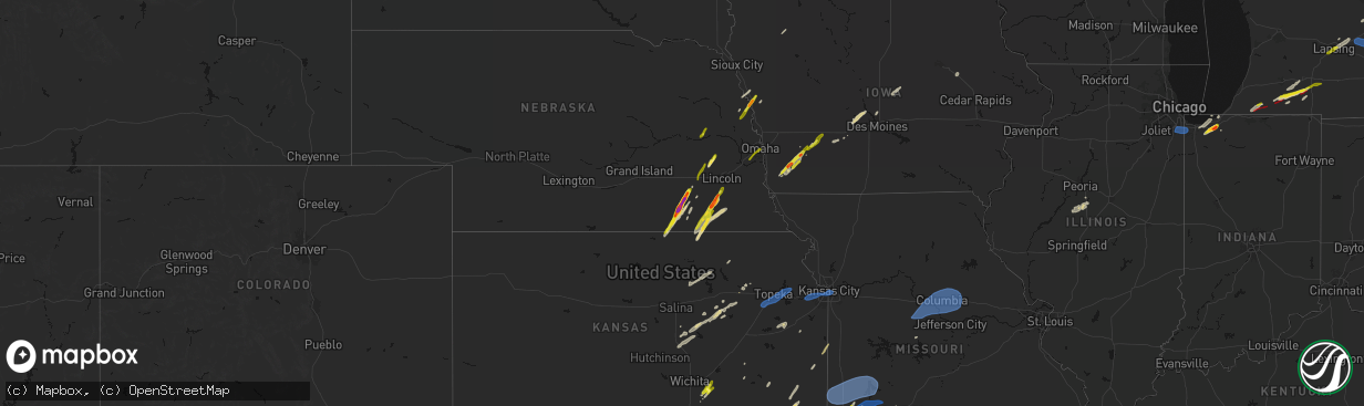
Hail
Tornado
Wind
106,757
Estimated number of impacted properties by a 1.00" hail or larger3,932
Estimated number of impacted properties by a 1.75" hail or larger696
Estimated number of impacted properties by a 2.50" hail or largerStates Impacted by Hail Map on March 6, 2026
Storm reports
Iowa
| Date | Description |
|---|---|
| 03/05/20268:43 PM CST | A local report indicates 1.00 inch wind near Blencoe |
| 03/05/20268:40 PM CST | A local report indicates 1.50 inch wind near 1 W Blencoe |
| 03/05/20266:12 PM CST | Report from mping. |
| 03/05/20266:11 PM CST | Report from mping. |
| 03/05/20266:05 PM CST | Report from mping. |
Georgia
| Date | Description |
|---|---|
| 03/06/20263:51 PM CST | Trained storm spotter reported quarter sized hail near camilla... Ga. |
Michigan
| Date | Description |
|---|---|
| 03/06/20263:58 PM CST | An ef0 tornado with top winds of 85 mph began just west of the intersection of p drive south and 18 1/2 mile road. The damage path ended near n drive south between 20 m |
| 03/06/20263:54 PM CST | Torn down exit sign. |
| 03/06/20263:38 PM CST | Storm chaser video confirmed tornado near union city. Location estimated based on radar. |
| 03/06/20263:38 PM CST | A local report indicates a tornado near 3 NW Union City |
| 03/06/20263:27 PM CST | A local report indicates 1.25 inch wind near 1 SE Athens |
| 03/06/20262:52 PM CST | Hail estimated to be between 1 to 1.5 inches in diameter seen in a photo on facebook from mendon... Mi. Time estimated via radar. |
| 03/06/20262:52 PM CST | Numerous reports of significant damage on the southwest side of three rivers. Storm chasers and emergency management confirmed multiple tornado touchdowns prior to the |
| 03/06/20262:51 PM CST | Photo on facebook shows a hailstone measured to be 1.75 inches. Public reports it fell between mendon and three rivers. Time estimated via radar. |
| 03/06/20262:50 PM CST | Numerous videos from storm chasers... Trained spotters... Broadcast media... And the public confirm a tornado in three rivers michigan. Time estimated via radar. |
| 03/06/20262:49 PM CST | Photo of hail up to a quarter in diameter in a photo taken on marcellus rd in three rivers. Time estimated via radar. |
| 03/06/20262:48 PM CST | Video relayed by broadcast media taken looking north at three rivers waste management facility. Tornado observed on the ground. Time estimated via radar. |
| 03/06/20262:46 PM CST | Video sent in showing a tornado hitting the menards store and lifted at least a portion of the roof off on main building. Their storage unit nearby was also damaged by |
| 03/06/20262:20 PM CST | Video shows hail up to a quarter in size in cassopolis... Time estimated via radar. |
| 03/06/20262:19 PM CST | Several trees snapped and damage to a home on harris street near m62. Photos on x. Time estimated via radar. |
| 03/06/20262:18 PM CST | Tree down and toppled center pivot in this location. Time estimated by radar. |
| 03/06/20262:11 PM CST | Picture obtained of damage to a house in this location. Time estimated by radar. |
| 03/05/20268:39 PM CST | Hail reported near hayes and 26 mile road. |
| 03/05/20266:27 PM CST | A local report indicates 1.00 inch wind near 1 NE East Lansing |
| 03/05/20266:19 PM CST | A local report indicates 1.00 inch wind near 1 NNW Lansing |
| 03/05/20266:17 PM CST | Report from mping: quarter |
| 03/05/20266:13 PM CST | A local report indicates 1.00 inch wind near 2 N Lansing |
Florida
| Date | Description |
|---|---|
| 03/06/20264:52 PM CST | Duke energy reported a power outage caused by fallen tree limbs at 5:52pm est. |
Arkansas
| Date | Description |
|---|---|
| 03/06/20265:40 AM CST | Public report of a trailer being lofted from a tornado near willisville. Tds signature associated with this storm in southern nevada county. |
| 03/06/20265:40 AM CST | *** 1 inj *** numerous trees down... A trailer was destroyed along with a barn. One injury taken to a local hospital. Most damage occurred along nevada 17 just west of |
| 03/06/20265:30 AM CST | Trees reported down by sebastian co sheriff and relateyed by amatuer radio... North of hartford along highway 45 and between hartford and mansfield on highway 96. Time |
Illinois
| Date | Description |
|---|---|
| 03/06/20264:26 PM CST | Tree branch reportedly fell onto a car on rose street. Wind gust of 58 mph provided as well. |
| 03/06/20264:20 PM CST | Grain bin... Tree... Small sheds... Playground set... Garage door... And soffit damage. Time estimated from radar. |
| 03/06/20264:20 PM CST | Semi truck blown over. Time estimated from radar. |
| 03/06/20264:10 PM CST | Large branch blown down across street. Time estimated from radar. |
| 03/06/20263:40 AM CST | Photos show farm outbuilding destroyed. Time estimated from radar. |
| 03/06/20263:30 AM CST | Numerous tree limbs and power lines down in salem. At least one large tree down/uprooted. Damage to at least one home caused by falling branches and/or downed tree. Tim |
| 03/05/202611:42 PM CST | Delayed report. Power pole snapped and tree blown over. Time estimated from radar. |
Nebraska
| Date | Description |
|---|---|
| 03/06/20264:43 PM CST | Nickel to quarter size hail. Most was smaller and did not last long. |
| 03/05/20269:37 PM CST | Picture via social media. Time estimated from radar. |
| 03/05/20268:31 PM CST | A local report indicates 1.00 inch wind near Tekamah |
| 03/05/20268:05 PM CST | Picture on social media showed a stone measuring 2.5 inches that fell southwest of laurel... Ne. Time estimated from radar. |
| 03/05/20267:30 PM CST | A local report indicates 1.00 inch wind near Seward |
| 03/05/20267:28 PM CST | Photo via social media. Located 5 mi north of valparaiso. |
| 03/05/20267:23 PM CST | A local report indicates 1.00 inch wind near Hallam |
| 03/05/20267:22 PM CST | Delayed report... Time estimated with radar. Image shared via social media. |
| 03/05/20267:19 PM CST | Report from mping. |
| 03/05/20267:15 PM CST | A local report indicates 1.75 inch wind near 1 SSW Clatonia |
| 03/05/20267:09 PM CST | A local report indicates 1.25 inch wind near 4 WNW Diller |
| 03/05/20267:05 PM CST | Photo of several 1.25 to 1.5 inch diameter stones. |
| 03/05/20267:03 PM CST | Image shared via social media. Delayed report... Time estimated from radar. |
| 03/05/20267:00 PM CST | A local report indicates 1.00 inch wind near Plymouth |
| 03/05/20266:33 PM CST | A local report indicates 2.00 inch wind near 3 WSW Milligan |
| 03/05/20266:29 PM CST | A local report indicates 1.75 inch wind near 1 NW Ohiowa |
| 03/05/20266:21 PM CST | A local report indicates 2.50 inch wind near Bruning |
| 03/05/20266:20 PM CST | A local report indicates 1.75 inch wind near Bruning |
| 03/05/20266:20 PM CST | A local report indicates 2.00 inch wind near Bruning |
| 03/05/20266:15 PM CST | Picture from facebook. |
| 03/05/20266:12 PM CST | Updated hail size from previous location. Found a few hailstones up to 1.5 inch diameter. |
| 03/05/20266:07 PM CST | A local report indicates 1.00 inch wind near 4 WNW Hebron |
Texas
| Date | Description |
|---|---|
| 03/06/20263:05 AM CST | *** 2 inj *** a tornado likely developed across north-central marion county just southwest of the prospect community and traveled northeast into southern cass county. A |
Oklahoma
| Date | Description |
|---|---|
| 03/06/20265:18 PM CST | Public report of tornado northwest side of bristow. |
| 03/06/20264:46 PM CST | A local report indicates 1.00 inch wind near Stroud |
| 03/06/20263:05 AM CST | Ardmore mesonet. |
| 03/06/20262:55 AM CST | Oklahoma mesonet. |
| 03/06/202612:55 AM CST | Corrects time from the previous report. Relayed via spotter network. |
| 03/06/202612:46 AM CST | A local report indicates 1.00 inch wind near Waurika |
| 03/05/20269:20 PM CST | A local report indicates 1.25 inch wind near Atoka |
| 03/05/20268:58 PM CST | Several storm trackers reported gusts of 80-90 mph on south side of pryor. |
| 03/05/20268:40 PM CST | Measured 66 mph wind gust at vinita mesonet. |
| 03/05/20268:27 PM CST | Tds from radar and reports of tornado from spotters. |
| 03/05/20268:14 PM CST | Report from mping: quarter |
| 03/05/20268:01 PM CST | Tds from radar and reports of power flashes at 91st s and the creek turnpike. |
| 03/05/20267:23 PM CST | *** 2 fatal... 2 inj *** an apparent tornado |
| 03/05/20267:19 PM CST | Tds on radar. |
| 03/05/20267:19 PM CST | Corrects previous tornado report from 1 n beggs. Tds on radar... Reports of damage in beggs. |
| 03/05/20266:54 PM CST | Tds from radar. |
| 03/05/20266:39 PM CST | Video on social media from storm chaser. |
| 03/05/20266:28 PM CST | Tds from radar. |
| 03/05/20266:24 PM CST | Report from mping: quarter |
Indiana
| Date | Description |
|---|---|
| 03/06/202612:57 PM CST | Location and time estimated by radar. Public commenter listed westville. |
Missouri
| Date | Description |
|---|---|
| 03/06/20262:06 AM CST | Em reports roof damage to older commercial building in booneville... First reported around 230am. Radar indicates a decaying storm may have produced a downburst around |
| 03/06/20261:01 AM CST | Kmbc tv photographer found downed power lines near lake tapawingo. Time estimated from radar. |
| 03/06/202612:32 AM CST | Report relayed via broadcast media livestream. |
| 03/06/202612:01 AM CST | Corrects time previous tstm wnd dmg report from lake tapawingo. Kmbc tv photographer found downed power lines near lake tapawingo. Time estimated from radar. |
| 03/05/202611:45 PM CST | Estimated 60 mph wind gusts in west plaza. |
| 03/05/202610:40 PM CST | Report of electric pole down on the roadway. |
| 03/05/202610:39 PM CST | Bradford farm missouri mesonet weather station measured wind gust. |
| 03/05/202610:35 PM CST | Report of a tree down on the roadway. |
| 03/05/202610:35 PM CST | Report of a 10 inch diameter tree over the roadway. |
| 03/05/202610:30 PM CST | Report from mping: quarter |
| 03/05/202610:30 PM CST | Tree reported down on roadway. |
| 03/05/202610:20 PM CST | 2 trees down and powerline down. |
| 03/05/202610:19 PM CST | Em reported 81 mph wind gust 7 mi wsw of goodman... Mo. |
| 03/05/202610:18 PM CST | Tree down at highway u and bentown ridge road. |
| 03/05/202610:15 PM CST | Em reported 78 mph wind gust 7 mi wsw of goodman... Mo. |
| 03/05/20269:58 PM CST | Delayed report. Spotter eyewitness report of short wind burst with damage to a boat dock at 3 mm of niangua river. Time estimated by radar. |
| 03/05/20269:03 PM CST | Power pole down. |
| 03/05/20268:30 PM CST | Tree down and power pole down 300 out of power. |
| 03/05/20268:18 PM CST | Mesonet station moa06 lamar. |
| 03/05/20268:18 PM CST | *** 1 inj *** semi turned over... Injury accident. |
| 03/05/20267:48 PM CST | Em reports wind damage on south street between 4th and main in booneville. Reports came in between 730p-815p. Radar shows a storm directly over this location around 748 |
| 03/05/20266:37 PM CST | A local report indicates 1.00 inch wind near 2 E Carthage |
Kansas
| Date | Description |
|---|---|
| 03/05/202611:43 PM CST | Pictures of downed trees on social media near and south of 39th st. Time estimated from radar. |
| 03/05/202611:39 PM CST | Reports of trees and power lines down. Time estimated from radar. |
| 03/05/202611:38 PM CST | Power flashes in merriam. |
| 03/05/202611:34 PM CST | Nws damage survey found evidence of a 7.9 mile long ef-0 tornado that began in shawnee... Crossing the state line into missouri... And ending shortly before reaching we |
| 03/05/20267:50 PM CST | *** 1 inj *** side of house blown in...1 injury. |
| 03/05/20267:28 PM CST | A local report indicates 1.00 inch wind near 2 N Douglass |
Alabama
| Date | Description |
|---|---|
| 03/06/20262:45 PM CST | 911 call center reported a tree down along cr 36 in eastern geneva county. Time estimated by radar. |
Mississippi
| Date | Description |
|---|---|
| 03/05/202610:46 PM CST | Reported ping pong sized hail in new town... Ms. |
| 03/05/202610:22 PM CST | A local report indicates 1.75 inch wind near 4 SE Pleasant Grove |
Cities Impacted by Hail Map on March 6, 2026
- Guthrie, OK
- Cashion, OK
- Piedmont, OK
- Stillwater, OK
- Mulhall, OK
- Orlando, OK
- Coyle, OK
- Edmond, OK
- Yukon, OK
- El Reno, OK
- Crescent, OK
- Tuttle, OK
- Fredonia, KS
- Rantoul, KS
- Buffalo, KS
- Benedict, KS
- Perry, OK
- Perkins, OK
- Tryon, OK
- Carney, OK
- Agra, OK
- Ripley, OK
- Cushing, OK
- Yale, OK
- Maramec, OK
- Eureka, KS
- Severy, KS
- Valparaiso, IN
- Westville, IN
- Covington, GA
- Niles, MI
- Edwardsburg, MI
- Cassopolis, MI
- Monroe, GA
- Vandalia, MI
- Three Rivers, MI
- Mcdonough, GA
- Lawrenceville, GA
- Dacula, GA
- Mendon, MI
- Buford, GA
- Nebo, NC
- Leonidas, MI
- Fulton, MI
- Cumming, GA
- Elberton, GA
- Morganton, NC
- Athens, MI
- Sherwood, MI
- Davis, OK
- Gainesville, GA
- Saint George, GA
- Union City, MI
- Burlington, MI
- Jackson, GA
- Colon, MI
- Toomsboro, GA
- Stockbridge, GA
- Paoli, OK
- Pauls Valley, OK
- Byars, OK
- Wayne, OK
- Wanette, OK
- Green Valley, IL
- Hennepin, OK
- San Jose, IL
- Mason City, IL
- Manito, IL
- Camilla, GA
- Marshall, MI
- Homer, MI
- Tekonsha, MI
- Chickasha, OK
- Elmore City, OK
- Delavan, IL
- Meeker, OK
- Shawnee, OK
- Ethel, LA
- Sanderson, FL
- Tremont, IL
- Hopedale, IL
- Ratliff City, OK
- Ninnekah, OK
- Newalla, OK
- Mcloud, OK
- Clinton, LA
- Harrah, OK
- Macomb, OK
- Sparks, OK
- Norman, OK
- Tecumseh, OK
- Lexington, OK
- Chandler, OK
- Stroud, OK
- Blackshear, GA
- Alma, GA
- Amber, OK
- Davenport, OK
- Noble, OK
- Lee, FL
- Mershon, GA
- Oklahoma City, OK
- Depew, OK
- Jennings, OK
- Drumright, OK
- Fayetteville, GA
- Jasper, FL
- Locust Grove, GA
- Bristow, OK
- Dyer, IN
- Saint John, IN
- Highland, IN
- Schererville, IN
- Chicago Heights, IL
- Munster, IN
- Crete, IL
- Flossmoor, IL
- Park Forest, IL
- Olympia Fields, IL
- Lansing, IL
- Homewood, IL
- Matteson, IL
- Steger, IL
- Glenwood, IL
- Thornton, IL
- Griffith, IN
- Terlton, OK
- Riverdale, GA
- Fairburn, GA
- Cleveland, OK
- Wellston, OK
- Randolph, IA
- Imogene, IA
- Mannford, OK
- Atlanta, GA
- Essex, IA
- Farragut, IA
- Morrow, GA
- Jonesboro, GA
- Hastings, IA
- Emerson, IA
- Republic, KS
- Byron, NE
- Red Oak, IA
- Deshler, NE
- Hebron, NE
- Palmetto, GA
- Newnan, GA
- Sapulpa, OK
- Sand Springs, OK
- Wann, OK
- Seneca, MO
- Trenton, FL
- Elliott, IA
- Dimondale, MI
- Lansing, MI
- Charlotte, MI
- Griswold, IA
- Carleton, NE
- Belvidere, NE
- Earlsboro, OK
- Longford, KS
- Clay Center, KS
- Seminole, OK
- Versailles, MO
- Douglasville, GA
- Bartlesville, OK
- Dewey, OK
- Baxter Springs, KS
- Old Town, FL
- Coffeyville, KS
- Tulsa, OK
- Sperry, OK
- Independence, KS
- East Lansing, MI
- Bruning, NE
- Neosho, MO
- Diamond, MO
- Joplin, MO
- Parsons, KS
- Prague, OK
- Paden, OK
- Copan, OK
- Strang, NE
- Boley, OK
- Atlantic, IA
- Cumberland, IA
- Owasso, OK
- Lewis, IA
- Wiota, IA
- Massena, IA
- Anita, IA
- Carthage, MO
- Erie, KS
- Galesburg, KS
- Castle, OK
- Ohiowa, NE
- Milligan, NE
- New Lothrop, MI
- Haslett, MI
- Laingsburg, MI
- Perry, MI
- Vicksburg, MI
- Caney, KS
- Okemah, OK
- Wewoka, OK
- Kellyville, OK
- Leonardville, KS
- Centreville, MI
- Skiatook, OK
- Collinsville, OK
- Exeter, NE
- Golden City, MO
- Reeds, MO
- Oologah, OK
- Friend, NE
- Fairbury, NE
- Morrowville, KS
- Hollenberg, KS
- Endicott, NE
- Washington, KS
- Owosso, MI
- Saint Paul, KS
- Montrose, MI
- Flushing, MI
- Sturgis, MI
- Claremore, OK
- Jansen, NE
- Plymouth, NE
- Prescott, KS
- Fulton, KS
- Beggs, OK
- Avilla, MO
- Steele City, NE
- Diller, NE
- Pleasanton, KS
- Redfield, KS
- Uniontown, KS
- Talala, OK
- Morrice, MI
- Gaines, MI
- Linden, MI
- Byron, MI
- Fowlerville, MI
- Bancroft, MI
- Howell, MI
- Durand, MI
- Fenton, MI
- Jasper, MO
- Beatrice, NE
- De Witt, NE
- Clatonia, NE
- Douglass, KS
- Cortland, NE
- Leon, KS
- Hallam, NE
- Udall, KS
- Garland, NE
- Valparaiso, NE
- Chelsea, OK
- Adel, IA
- Bee, NE
- Dwight, NE
- Rock, KS
- Foster, MO
- Amoret, MO
- Olsburg, KS
- Martell, NE
- Hickman, NE
- Roca, NE
- Frankfort, KS
- Galva, KS
- Canton, KS
- Roxbury, KS
- Earlham, IA
- Woodward, IA
- Dallas Center, IA
- Minburn, IA
- Granger, IA
- Mounds, OK
- Butler, MO
- Amsterdam, MO
- Adrian, MO
- Ann Arbor, MI
- Stuart, IA
- Bixby, OK
- Lehigh, KS
- Durham, KS
- Madrid, IA
- Broken Arrow, OK
- Vinita, OK
- Augusta, KS
- Schuyler, NE
- Hope, KS
- Columbus, KS
- Ankeny, IA
- Alleman, IA
- Catoosa, OK
- Sutherland, IA
- Tampa, KS
- Colo, IA
- Rose Hill, KS
- Lamar, MO
- Sheldon, MO
- Liberal, MO
- Oronogo, MO
- Bronaugh, MO
- Mindenmines, MO
- Asbury, MO
- Lockwood, MO
- Jerico Springs, MO
- Inola, OK
- Glenpool, OK
- Ramona, KS
- Jenks, OK
- Zearing, IA
- State Center, IA
- Saint Anthony, IA
- Herington, KS
- Moundridge, KS
- Tekamah, NE
- Hillsboro, KS
- Clemons, IA
- Pryor, OK
- White City, KS
- Greenfield, MO
- Arcola, MO
- El Dorado Springs, MO
- Stockton, MO
- South Greenfield, MO
- Everton, MO
- Walnut Grove, MO
- Aldrich, MO
- Dadeville, MO
- Fair Play, MO
- Adair, OK
- Marion, KS
- Big Cabin, OK
- Garden City, MN
- Amboy, MN
- Vernon Center, MN
- Madelia, MN
- Junction City, KS
- Alma, KS
- Dwight, KS
- Blencoe, IA
- Bluejacket, OK
- Alta Vista, KS
- Welch, OK
- Craig, NE
- Herman, NE
- Onawa, IA
- Dunnegan, MO
- La Porte, IN
- Coldwater, MI
- Bronson, MI
- Pickrell, NE
- Strang, OK
- Alexandria, NE
- Gilead, NE
- Filley, NE
- Wamego, KS
- Tobias, NE
- Geneva, NE
- Bath, MI
- Lincolnville, KS
- Lost Springs, KS
- Dewitt, MI
- Atoka, OK
- Caney, OK
- Daykin, NE
- Western, NE
- Dorchester, NE
- Climax, MI
- Battle Creek, MI
- Scotts, MI
- East Leroy, MI
- Chester, NE
- Saint Marys, KS
- Mahaska, KS
- Miami, OK
- Stringtown, OK
- Moorhead, IA
- Mcalester, OK
- Eufaula, OK
- Mankato, MN
- Council Hill, OK
- Checotah, OK
- Council Grove, KS
- Belvue, KS
- Decatur, NE
- Eucha, OK
- Spavinaw, OK
- Chouteau, OK
- Salina, OK
- Haskell, OK
- Coweta, OK
- Okmulgee, OK
- Locust Grove, OK
- Oktaha, OK
- Boynton, OK
- Pittsburg, OK
- Coalgate, OK
- Wardville, OK
- Kiowa, OK
- Stuart, OK
- Weston, NE
- Milford, NE
- Seward, NE
- Springfield, NE
- Papillion, NE
- Jay, OK
- La Porte City, IA
- Brandon, IA
- Grove, OK
- Wilsey, KS
- La Vista, NE
- Omaha, NE
- Bellevue, NE
- Michigan City, IN
- Muskogee, OK
- Union Mills, IN
- Afton, OK
- Kouts, IN
- Wanatah, IN
- Portage, IN
- Beverly Shores, IN
- Chesterton, IN
- Hobart, IN
- Anderson, MO
- Wyandotte, OK
- South West City, MO
- Lambert, MS
- Marks, MS
- Batesville, MS
- Blanco, OK
- Tiff City, MO
- Porter, OK
- Goodman, MO
- Sledge, MS
- Crenshaw, MS
- Sardis, MS
- Granby, MO
- Hartshorne, OK
- Stella, MO
- Sarcoxie, MO
- Pierce City, MO
- Como, MS
- Oakland, IA
- Treynor, IA
- Krebs, OK
- Auburn, KS
- Burlingame, KS
- Wakarusa, KS
- Carbondale, KS
- Berryton, KS
- Topeka, KS
- Tecumseh, KS
- Perry, KS
- Grantville, KS
- Lecompton, KS
- Oskaloosa, KS
- Fort Gibson, OK
- Tahlequah, OK
- Senatobia, MS
- Rose, OK
- Miller, MO
- La Russell, MO
- Stotts City, MO
- Wentworth, MO
- Stark City, MO
- Hulbert, OK
- Wagoner, OK
- Warner, OK
- Twin Oaks, OK
- Kansas, OK
- Oaks, OK
- Lane, KS
- Mount Vernon, MO
- Ash Grove, MO
- Monett, MO
- Freistatt, MO
- Verona, MO
- Quenemo, KS
- Melvern, KS
- Colcord, OK
- De Soto, KS
- Eudora, KS
- Linwood, KS
- Bonner Springs, KS
- Olathe, KS
- Aurora, MO
- Willard, MO
- Shawnee, KS
- Lenexa, KS
- Greenfield, IA
- Fontanelle, IA
- Peggs, OK
- Watts, OK
- Pomona, KS
- Kinta, OK
- Quinton, OK
- Ottawa, KS
- Kansas City, KS
- Liberty, KS
- Stigler, OK
- Maysville, AR
- Gravette, AR
- Syracuse, MO
- Otterville, MO
- Bunceton, MO
- Tipton, MO
- Boonville, MO
- Wooldridge, MO
- Prairie Home, MO
- Jamestown, MO
- Clarksburg, MO
- California, MO
- Columbia, MO
- Hartsburg, MO
- Ashland, MO
- Fulton, MO
- New Bloomfield, MO
- Rocheport, MO
- Kingdom City, MO
- New Franklin, MO
- Centralia, MO
- Auxvasse, MO
- Harrisburg, MO
- Hallsville, MO
- Thompson, MO
- Mexico, MO
- Prairie Village, KS
- Mission, KS
- Kansas City, MO
- Duncan, OK
- Comanche, OK
- Altamont, KS
- Mound Valley, KS
- Edna, KS
- Throckmorton, TX
- Lenapah, OK
- Maysville, OK
- S Coffeyville, OK
- Delaware, OK
- Springfield, MO
- Tussy, OK
- Exeter, MO
- Cassville, MO
- Gore, OK
- Marlow, OK
- Foster, OK
- Waurika, OK
- Pineville, MO
- Bella Vista, AR
- Wichita Falls, TX
- Newcastle, TX
- Oswego, KS
- Abilene, TX
- Powell, MO
- Washburn, MO
- Red Oak, OK
- Webbers Falls, OK
- Braggs, OK
- Cherryvale, KS
- Purdy, MO
- Holliday, TX
- Vian, OK
- Pea Ridge, AR
- Seligman, MO
- Caddo, OK
- Park Hill, OK
- Albany, TX
- Olney, TX
- McCune, KS
- Lindsay, OK
- Muldrow, OK
- Crane, MO
- Bunch, OK
- Stilwell, OK
- West Fork, AR
- Natural Dam, AR
- Prairie Grove, AR
- Canehill, AR
- Cookson, OK
- Uniontown, AR
- Galena, MO
- Keota, OK
- Centertown, MO
- Bokoshe, OK
- Scotland, TX
- Windthorst, TX
- Chester, AR
- Winslow, AR
- Malta Bend, MO
- Miami, MO
- Henrietta, TX
- Fayetteville, AR
- Choctaw, OK
- Scammon, KS
- Midkiff, TX
- Asher, OK
- Stratford, OK
- Bellevue, TX
- Gladewater, TX
- Mountainburg, AR
- Maud, OK
- Constantine, MI
- Sterling City, TX
- Robert Lee, TX
- Marcellus, MI
- Schoolcraft, MI
- Big Lake, TX
- Midland, TX
- Garden City, TX
- Healdton, OK
- Graham, OK
- Maryneal, TX
- Omaha, AR
- Malcolm, NE
- Konawa, OK
- Bowlegs, OK
- Wynnewood, OK
- Springer, OK
- Loraine, TX
- Saint Paul, AR
- Combs, AR
- Elkins, AR
- Ozark, AR
- Jacksboro, TX
- Utica, MI
- Macomb, MI
- Washington, MI
- Ray, MI
- Mears, MI
- Pentwater, MI
- Hart, MI
- Roscoe, TX
- Blackwell, TX
- Wilson, OK
- Custer, MI
- Scottville, MI
- Branch, MI
- Lone Grove, OK
- Ardmore, OK
- Sulphur, OK
- Weleetka, OK
- Roff, OK
- Ada, OK
- Jefferson, TX
- Baldwin, MI
- Idlewild, MI
- Willow Springs, MO
- Dora, MO
- Pomona, MO
- Pottersville, MO
- West Plains, MO
- Henryetta, OK
- Fitzhugh, OK
- Mill Creek, OK
- Dougherty, OK
- Mountain View, MO
- Stonewall, OK
- Tishomingo, OK
- Tupelo, OK
- Eminence, MO
- Peace Valley, MO
- Birch Tree, MO
- Welling, OK
- Clyde, TX
- Baird, TX
- Lincoln, AR
- Evansville, AR
- Moran, TX
- Bronte, TX
- Quapaw, OK
- Cisco, TX
- Breckenridge, TX
- Eastland, TX
- Booneville, AR
- Magazine, AR
- Forestburg, TX
- Rosston, AR
- Nashville, AR
- Ozan, AR
- Haddam, KS
- Symsonia, KY
- Murray, KY
- Carlock, IL
- Danvers, IL
- Randolph, NE
- Belden, NE
- Carroll, NE
- Laurel, NE
- Dixon, NE