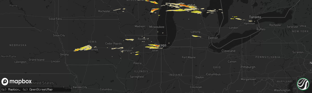
Hail Map on March 30, 2026
The weather event on March 30, 2026 includes Hail and Wind maps. 7 states and 346 cities were impacted and suffered possible damage. The total estimated number of properties impacted is 363,188.
Hail
Wind
363,188
Estimated number of impacted properties by a 1.00" hail or larger57,247
Estimated number of impacted properties by a 1.75" hail or larger0
Estimated number of impacted properties by a 2.50" hail or largerStorm reports
Wisconsin
| Date | Description |
|---|---|
| 03/30/202612:32 AM CDT | Report from mping: golf ball |
| 03/30/202612:11 AM CDT | Relayed via social media. |
| 03/30/202612:10 AM CDT | Report from mping: quarter |
| 03/30/202612:05 AM CDT | A local report indicates 1.25 inch wind near 2 WNW Ashwaubenon |
| 03/30/202612:03 AM CDT | Relayed via nws employee. |
| 03/29/202611:21 PM CDT | Report from mping: quarter |
| 03/29/202611:15 PM CDT | Public report of quarter sized hail with photos in sheboygan. |
| 03/29/202611:02 PM CDT | Report from mping: golf ball |
| 03/29/202610:28 PM CDT | A local report indicates 1.75 inch wind near 1 SW Evergreen |
Texas
| Date | Description |
|---|---|
| 03/30/20266:04 PM CDT | One-mile visibility from blowing dust. |
| 03/30/20265:38 PM CDT | West texas mesonet. |
| 03/30/20265:35 PM CDT | Corrects previous tstm wnd gst report from 1 ene mclean. Severe wind gusts measured at mesonet station 44 mclean 1e. Strongest gust of 64 mph. |
| 03/30/20265:24 PM CDT | West texas mesonet. |
| 03/30/20264:31 PM CDT | Severe wind gust measured at mesonet station 85 goodnight. |
| 03/29/20268:36 PM CDT | Multiple phone calls of golf ball sized hail in memphis... With lots of hail on the ground. |
| 03/29/20268:29 PM CDT | Hall county sheriff office reported lots of ping pong ball sized hail in memphis. |
| 03/29/20267:52 PM CDT | West texas mesonet. Gusts occurred as storms were collapsing. |
| 03/29/20267:20 PM CDT | West texas mesonet. |
| 03/29/20267:18 PM CDT | West texas mesonet. |
| 03/29/20267:05 PM CDT | West texas mesonet. |
Michigan
| Date | Description |
|---|---|
| 03/30/20263:50 AM CDT | Time estimated via radar. |
| 03/30/20263:38 AM CDT | A local report indicates 1.00 inch wind near 3 S Eaton Rapids |
| 03/30/20261:40 AM CDT | A local report indicates 1.00 inch wind near Luther |
| 03/30/20261:40 AM CDT | A local report indicates 1.00 inch wind near Tustin |
| 03/30/20261:40 AM CDT | Picture relayed via social media/x. |
| 03/30/20261:10 AM CDT | A local report indicates 1.25 inch wind near Freesoil |
| 03/30/20261:04 AM CDT | Social media picture of hail from lake city. Time estimated via radar. |
| 03/30/202612:27 AM CDT | Social media report with picture of 1.5 in. To 2 in. Hail in mesick. Time estimated via radar. |
| 03/30/202612:23 AM CDT | Images shared via social media. |
| 03/29/202610:59 PM CDT | A local report indicates 1.00 inch wind near 7 E Irons |
Oklahoma
| Date | Description |
|---|---|
| 03/29/202611:20 PM CDT | Due to heat burst. |
| 03/29/202610:50 PM CDT | Due to heat burst. |
| 03/29/20268:25 PM CDT | Due to heat burst. |
| 03/29/20267:55 PM CDT | Due to heat burst. |
| 03/29/20267:50 PM CDT | Due to heat burst. |
| 03/29/20267:30 PM CDT | Due to heat burst. |
Iowa
| Date | Description |
|---|---|
| 03/29/202610:45 PM CDT | A local report indicates 1.00 inch wind near 2 NNE Windsor Heights |
| 03/29/202610:35 PM CDT | A local report indicates 1.00 inch wind near 1 SSE Waukee |
| 03/29/202610:34 PM CDT | A local report indicates 1.25 inch wind near 1 W Waukee |
| 03/29/202610:34 PM CDT | A local report indicates 1.00 inch wind near Waukee |
| 03/29/202610:17 PM CDT | A local report indicates 1.00 inch wind near Ankeny |
| 03/29/202610:16 PM CDT | Report from mping: quarter |
| 03/29/20269:49 PM CDT | A local report indicates 1.00 inch wind near 2 S Minburn |
| 03/29/20268:41 PM CDT | A local report indicates 1.00 inch wind near 6 ENE Marne |
Illinois
| Date | Description |
|---|---|
| 03/30/20266:36 AM CDT | Relayed via nws chicago. Spotter reports hail ranging from half into to quarter size. |
| 03/29/202611:23 PM CDT | Time estimated from radar. |
| 03/29/202611:20 PM CDT | Report from mping: quarter |
| 03/29/202611:18 PM CDT | A local report indicates 1.00 inch wind near Westchester |
| 03/29/202611:18 PM CDT | Time estimated from radar. |
| 03/29/202611:18 PM CDT | Report from mping: quarter |
| 03/29/202611:15 PM CDT | A local report indicates 1.25 inch wind near 1 N McCook |
| 03/29/202611:14 PM CDT | Time estimated via radar. |
| 03/29/202611:14 PM CDT | Report from mping: quarter |
| 03/29/202611:13 PM CDT | Time estimated via radar. |
| 03/29/202611:04 PM CDT | Time estimated via radar. |
| 03/29/202611:04 PM CDT | Time estimated via radar. |
| 03/29/202611:00 PM CDT | Report relayed via em. Time estimated from radar. |
| 03/29/202610:50 PM CDT | Photo shared via office service account showed hail ranging from 1 to 1.25 inches in diameter. |
| 03/29/202610:36 PM CDT | Video shared on social media shows hail of quarter to half dollar sized hail near the dupage airport. Time estimated via radar. |
| 03/29/202610:29 PM CDT | Report from mping: half dollar |
| 03/29/202610:26 PM CDT | Time estimated from radar. |
| 03/29/202610:26 PM CDT | Report from mping: half dollar |
| 03/29/202610:23 PM CDT | Time estimated via radar. |
| 03/29/202610:22 PM CDT | Time estimated via radar. |
| 03/29/202610:18 PM CDT | Report from mping: half dollar |
| 03/29/202610:15 PM CDT | Time estimated from radar. |
| 03/29/202610:13 PM CDT | A local report indicates 1.00 inch wind near 2 NW Montgomery |
| 03/29/202610:12 PM CDT | Corrects the time previous hail report from aurora. Report of nickel to quarter sized hail in aurora. Time estimated via radar. |
| 03/29/202610:12 PM CDT | Time estimated via radar. |
| 03/29/202610:05 PM CDT | A local report indicates 1.00 inch wind near Big Rock |
| 03/29/202610:02 PM CDT | A local report indicates 1.00 inch wind near 2 W Oswego |
| 03/29/20269:50 PM CDT | Photo shared to office email account showing hail measuring 1 inch in diameter. |
| 03/29/20269:11 PM CDT | Large tree downed at the outskirts of the u.s. Savanna army depot. Time estimated via radar. |
Cities Impacted by Hail Map on March 30, 2026
- Dimmitt, TX
- Hedley, TX
- Clarendon, TX
- Lelia Lake, TX
- Mclean, TX
- Shamrock, TX
- Wellington, TX
- Lubbock, TX
- Shallowater, TX
- Wolfforth, TX
- Lakeview, TX
- Memphis, TX
- Turkey, TX
- Quitaque, TX
- Floydada, TX
- Brayton, IA
- Exira, IA
- Atlantic, IA
- Dodson, TX
- Adair, IA
- Zwingle, IA
- Guthrie Center, IA
- Anita, IA
- Bellevue, IA
- La Motte, IA
- Casey, IA
- Baldwin, IA
- Marne, IA
- Panora, IA
- Stuart, IA
- Menlo, IA
- Savanna, IL
- Yale, IA
- Linden, IA
- Dawson, IA
- Hanover, IL
- Elizabeth, IL
- Lee, IL
- Paw Paw, IL
- Shabbona, IL
- Redfield, IA
- Perry, IA
- Waterman, IL
- Adel, IA
- Minburn, IA
- Hinckley, IL
- Earlville, IL
- Somonauk, IL
- Sandwich, IL
- Bouton, IA
- Big Rock, IL
- Mount Carroll, IL
- Stockton, IL
- Pearl City, IL
- Dallas Center, IA
- Sugar Grove, IL
- Plano, IL
- Woodward, IA
- Yorkville, IL
- Polk City, IA
- Madrid, IA
- Granger, IA
- Aurora, IL
- Grimes, IA
- Bristol, IL
- Montgomery, IL
- Oswego, IL
- Maple Park, IL
- Elburn, IL
- Waukee, IA
- Sheldahl, IA
- Earlham, IA
- Dexter, IA
- Johnston, IA
- Junction City, WI
- North Aurora, IL
- Ankeny, IA
- Naperville, IL
- Plainfield, IL
- Bolingbrook, IL
- Romeoville, IL
- Lemont, IL
- Woodridge, IL
- Clare, MI
- Leroy, MI
- Tustin, MI
- Geneva, IL
- Batavia, IL
- Mosinee, WI
- Alleman, IA
- Slater, IA
- Des Moines, IA
- Marion, MI
- Harrison, MI
- Evart, MI
- West Chicago, IL
- Winfield, IL
- Wheaton, IL
- Warrenville, IL
- West Des Moines, IA
- Clive, IA
- Urbandale, IA
- Lockport, IL
- Gladwin, MI
- Beaverton, MI
- Hatley, WI
- Rosholt, WI
- Davis Junction, IL
- Monroe Center, IL
- Wittenberg, WI
- Elkhart, IA
- Windsor Heights, IA
- Villa Park, IL
- Downers Grove, IL
- Oak Brook, IL
- Westmont, IL
- Lombard, IL
- Westchester, IL
- Hillside, IL
- Hinsdale, IL
- Racine, WI
- Sturtevant, WI
- Falmouth, MI
- Irons, MI
- Palos Heights, IL
- Orland Park, IL
- Palos Hills, IL
- Palos Park, IL
- Worth, IL
- Homer Glen, IL
- Lisle, IL
- Glen Ellyn, IL
- Rhodes, MI
- Bentley, MI
- Alsip, IL
- Malone, WI
- Blanchard, MI
- Chilton, WI
- Hilbert, WI
- Stockbridge, WI
- Riverside, IL
- Clarendon Hills, IL
- Brookfield, IL
- Lyons, IL
- Cicero, IL
- Broadview, IL
- Western Springs, IL
- La Grange, IL
- Berwyn, IL
- La Grange Park, IL
- Luther, MI
- Willowbrook, IL
- Elmhurst, IL
- East Chicago, IN
- Chicago, IL
- Whiting, IN
- Hammond, IN
- Summit Argo, IL
- Willow Springs, IL
- Shawano, WI
- Tigerton, WI
- Chicago Ridge, IL
- Oak Lawn, IL
- Standish, MI
- Kiel, WI
- Clintonville, WI
- Marion, WI
- Riverdale, IL
- Bridgeview, IL
- Justice, IL
- Hickory Hills, IL
- Burbank, IL
- Berwick, IA
- Reedsville, WI
- Potter, WI
- Brillion, WI
- Whitelaw, WI
- Lake City, MI
- Merritt, MI
- McBain, MI
- Collins, WI
- Grayling, MI
- Frederic, MI
- Embarrass, WI
- Farwell, MI
- Newton, IA
- Port Austin, MI
- Gresham, WI
- Manitowoc, WI
- Two Rivers, WI
- Sturgeon Bay, WI
- Brussels, WI
- Pulaski, WI
- Bonduel, WI
- Cadillac, MI
- Black Creek, WI
- Shiocton, WI
- Houghton Lake, MI
- Port Hope, MI
- Sheboygan, WI
- Houghton Lake Heights, MI
- Sherwood, WI
- Menasha, WI
- Oshkosh, WI
- Seymour, WI
- De Soto, IA
- New Holstein, WI
- Green Bay, WI
- Oneida, WI
- Arcadia, MI
- Bear Lake, MI
- New Franken, WI
- Kewaunee, WI
- Suttons Bay, MI
- Mesick, MI
- Copemish, MI
- Suamico, WI
- Kaleva, MI
- Mingo, IA
- Baxter, IA
- Ira, IA
- Bondurant, IA
- Colfax, IA
- Maxwell, IA
- Mitchellville, IA
- Luxemburg, WI
- Harrietta, MI
- Bellaire, MI
- Manton, MI
- Boon, MI
- Marengo, IA
- Ladora, IA
- Alger, MI
- Caseville, MI
- Manistee, MI
- Onekama, MI
- Ludington, MI
- Free Soil, MI
- Sterling, MI
- Omer, MI
- Twining, MI
- Prescott, MI
- Kinde, MI
- Whittemore, MI
- Thompsonville, MI
- Scottville, MI
- Fountain, MI
- Branch, MI
- Maquoketa, IA
- Buckley, MI
- Baldwin, MI
- Durand, IL
- Williamsburg, IA
- Oxford, IA
- Turner, MI
- Prudenville, MI
- Kingsley, MI
- Wellston, MI
- Parnell, IA
- Brethren, MI
- Rockton, IL
- Machesney Park, IL
- Roscoe, IL
- Loves Park, IL
- Rockford, IL
- Filion, MI
- Elkton, MI
- Iowa City, IA
- Wellman, IA
- Coralville, IA
- Caledonia, IL
- West Branch, IA
- Lake, MI
- Marengo, IL
- West Liberty, IA
- Stillman Valley, IL
- Tipton, IA
- Atalissa, IA
- Stockton, IA
- Wilton, IA
- Bennett, IA
- Olivet, MI
- Bellevue, MI
- Charlotte, MI
- Pinconning, MI
- Hope, MI
- Walcott, IA
- New Liberty, IA
- Durant, IA
- Eaton Rapids, MI
- Springport, MI
- Onondaga, MI
- Rives Junction, MI
- Leslie, MI
- Pleasant Lake, MI
- Munith, MI
- Stockbridge, MI
- Muscatine, IA
- Chelsea, MI
- Grass Lake, MI
- Gregory, MI
- Blue Grass, IA
- Saint Charles, MI
- Illinois City, IL
- Gilberts, IL
- Taylor Ridge, IL
- Algonquin, IL
- Carol Stream, IL
- Darien, IL
- Dolton, IL
- Auburndale, WI
- Eland, WI
- Edgar, WI
- Stratford, WI
- Wausau, WI
- Rothschild, WI
- Cambridge, IL
- Geneseo, IL
- Atkinson, IL
- Annawan, IL
- Buda, IL
- Neponset, IL
- Bradford, IL
- Toulon, IL
- Wyanet, IL
- Sheffield, IL
- Tiskilwa, IL
- Mineral, IL
- Erie, IL
- Prophetstown, IL
- Princeton, IL
- Ettrick, WI
- Galesville, WI
- Trempealeau, WI
- Dodge, WI
- Fountain City, WI
- Winona, MN
- Black River Falls, WI
- Sparta, WI
- Melrose, WI
- Mediapolis, IA
- Oakville, IA
- Saint Charles, IL
- Saint Helen, MI
- Roscommon, MI
- Elgin, IL