Hail Map on April 10, 2026
The weather event on April 10, 2026 includes Hail map. 9 states and 61 cities were impacted and suffered possible damage. The total estimated number of properties impacted is 6,909.
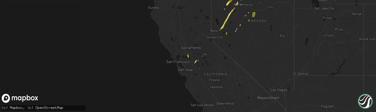
Hail
6,909
Estimated number of impacted properties by a 1.00" hail or larger0
Estimated number of impacted properties by a 1.75" hail or larger0
Estimated number of impacted properties by a 2.50" hail or largerStates Impacted by Hail Map on April 10, 2026
Storm reports
Texas
| Date | Description |
|---|---|
| 04/10/20263:48 PM CDT | Quarter sized hail falling on highway 54 ne of dalhart. Public confirmation. |
Nevada
| Date | Description |
|---|---|
| 04/10/20266:50 PM CDT | Peak outflow gust at mesonet station nv013 northwest reno. |
| 04/09/20268:43 PM CDT | Station id: martin creek |
| 04/09/20268:32 PM CDT | Peak outflow gust at mesonet station wlknv 6.1 nw hawthorne |
| 04/09/20267:45 PM CDT | Peak outflow gust at mesonet station rgx virginia peak. |
| 04/09/20267:37 PM CDT | Station id: morey creek |
California
| Date | Description |
|---|---|
| 04/10/20265:04 PM CDT | Trained spotter reports 1.5 inch / ping pong hail in rio vista. |
Cities Impacted by Hail Map on April 10, 2026
- Depew, OK
- Bristow, OK
- Reno, NV
- Sparks, NV
- Wadsworth, NV
- Austin, NV
- Fernley, NV
- Dalhart, TX
- Fallon, NV
- Ripon, CA
- Manteca, CA
- Escalon, CA
- Hilmar, CA
- Garita, NM
- Adrian, TX
- San Jon, NM
- Lovelock, NV
- Trementina, NM
- Battle Mountain, NV
- Winnemucca, NV
- Oakley, CA
- Bethel Island, CA
- Rio Vista, CA
- Conchas Dam, NM
- Isleton, CA
- Clovis, NM
- Shawnee, OK
- Earlsboro, OK
- Prague, OK
- Imlay, NV
- Orovada, NV
- Roswell, NM
- Salt Flat, TX
- Longdale, OK
- Canton, OK
- Jordan Valley, OR
- Elida, NM
- Farmington, CA
- Grand View, ID
- Mountain Ranch, CA
- San Andreas, CA
- Avery, CA
- Arnold, CA
- Murphys, CA
- Jewell, KS
- Beloit, KS
- Burr Oak, KS
- Mankato, KS
- Randall, KS
- Jamestown, KS
- Superior, NE
- Kirwin, KS
- Woodston, KS
- Stockton, KS
- Gaylord, KS
- Cedar, KS
- Kensington, KS
- Athol, KS
- Smith Center, KS
- Concordia, KS
- Glasco, KS