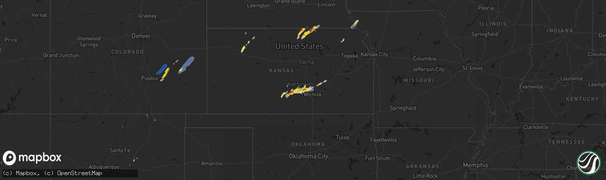
Hail Map on April 11, 2026
The weather event on April 11, 2026 includes Hail, Wind, and Tornado maps. 12 states and 119 cities were impacted and suffered possible damage. The total estimated number of properties impacted is 8,317.
Hail
Wind
Tornado
8,317
Estimated number of impacted properties by a 1.00" hail or larger988
Estimated number of impacted properties by a 1.75" hail or larger41
Estimated number of impacted properties by a 2.50" hail or largerStates Impacted by Hail Map on April 11, 2026
Storm reports
Utah
| Date | Description |
|---|---|
| 04/11/20262:54 PM CDT | Report from mping: half dollar |
| 04/11/20262:45 PM CDT | Mesonet station hatut hat island. |
| 04/11/20261:30 PM CDT | A local report indicates 62 MPH wind near 2 SSW Grantsville |
| 04/11/202612:56 PM CDT | Mesonet station fw8325 garden city. |
Nebraska
| Date | Description |
|---|---|
| 04/10/20268:21 PM CDT | Awos station kfnb falls city airport. |
Idaho
| Date | Description |
|---|---|
| 04/11/20264:30 PM CDT | Mesonet station rrwbt relay ridge wind. |
| 04/11/20262:00 PM CDT | Mesonet station grei 1 nw niter. |
| 04/11/20261:40 PM CDT | Mesonet station pc506 sheep creek hills. |
Missouri
| Date | Description |
|---|---|
| 04/10/20269:06 PM CDT | Report from personal weather station. Time matches with when the core of the storm passed over the station on radar. |
Montana
| Date | Description |
|---|---|
| 04/11/20264:45 PM CDT | 58 mph convective wind gust. |
| 04/10/20269:42 PM CDT | Glasgow asos. |
| 04/10/20268:40 PM CDT | Jordan airport station. |
| 04/10/20267:30 PM CDT | Malta south mt dot station. |
| 04/10/20267:15 PM CDT | Winnett mt dot surface station. |
New Mexico
| Date | Description |
|---|---|
| 04/11/20266:36 PM CDT | Corrects previous non-tstm wnd gst report from 1 e clayton. Asos station kcao clayton muni airpark. |
| 04/11/20266:20 PM CDT | Mesonet station swcn5 sw clayton. |
| 04/11/20265:14 PM CDT | Asos station kfmn farmington airport from a virga |
Texas
| Date | Description |
|---|---|
| 04/11/20263:46 PM CDT | Mesonet station 123 1nw castolon... Bbnp big bend np/brewster. |
California
| Date | Description |
|---|---|
| 04/10/20269:14 PM CDT | California highway patrol reported a downed tree. Wind gusts in the area measured between 30 to 40 mph. |
| 04/10/20269:13 PM CDT | California highway patrol reported a downed tree blocking all lanes. Wind gusts in the area measured between 30 and 40 mph. |
| 04/10/20268:30 PM CDT | Trained spotter reported a small downed tree with thunderstorms in elk grove. Nearby wind gusts measured 42 mph. |
Wyoming
| Date | Description |
|---|---|
| 04/11/20265:57 PM CDT | 70 mph wind gust recorded at verne1 |
| 04/11/20265:40 PM CDT | Mesonet station pc462 irma lake |
| 04/11/20265:38 PM CDT | Asos station kbyg buffalo airport |
| 04/11/20265:30 PM CDT | Mesonet station pc460 buffalo south |
| 04/11/20265:22 PM CDT | Mesonet station krec wy28 red canyon |
| 04/11/20265:20 PM CDT | Mesonet station pc577 midwest |
| 04/11/20265:16 PM CDT | I80 coal road wydot sensor reported a 58 mph wind gust. |
| 04/11/20265:10 PM CDT | First divide wydot sensor reported a 66 mph gust. |
| 04/11/20265:02 PM CDT | Corrects previous tstm wnd gst report from 3 w evanston. Evanston-uinta county airport reported a gust of 64 mph. |
| 04/11/20265:02 PM CDT | Medicine butte cwop reported a gust of 69 mph. |
| 04/11/20262:50 PM CDT | Mesonet station pc452 cottonwood merna |
| 04/11/20262:00 PM CDT | Mesonet station ew1855 etna 1 |
Oklahoma
| Date | Description |
|---|---|
| 04/10/20269:07 PM CDT | Wind gust of 59 mph measured at the asos station kguy guymon |
Colorado
| Date | Description |
|---|---|
| 04/11/20266:54 PM CDT | Kitr reported a 72 mph gust. |
| 04/11/20266:46 PM CDT | Asos station keeo meeker airport. |
| 04/11/20266:39 PM CDT | Mesonet station co068 040w460 u40-firstview. |
| 04/11/20266:14 PM CDT | Up729 |
| 04/11/20266:10 PM CDT | Chaser recorded 70 mph winds and 2 mile visibility in blowing dust. Wind speed measure via handheld anemometer. |
| 04/11/20265:35 PM CDT | Personal weather station measured a 61 mph wind gust. |
| 04/11/20265:15 PM CDT | Local resident reported an outflow wind blew the roof off of his rv barn. An approximately 40ft x 20ft section. |
| 04/11/20261:42 PM CDT | A local report indicates 58 MPH wind near 3 E Rifle |
| 04/10/20268:45 PM CDT | Tt563 site reported a 68 mph gust. |
| 04/10/20268:00 PM CDT | Corrects previous tstm wnd gst report from hale. Tt563 site reported a 68 mph gust. |
| 04/10/20267:57 PM CDT | Mesonet station dhoc2 dead horse... Buford 14ene. |
| 04/10/20267:40 PM CDT | Asos station kitr burlington co airport. |
| 04/10/20267:38 PM CDT | Kcoidali9 |
| 04/10/20267:37 PM CDT | Public report of blowing dust with visibility to 1/2 mile with 60 mph wind gust. |
| 04/10/20267:11 PM CDT | Kcostrat21 |
| 04/10/20267:11 PM CDT | Sevenfarms |
Iowa
| Date | Description |
|---|---|
| 04/11/20262:55 AM CDT | Picture of hail north of thompson. Relayed by kiow radio. |
Oregon
| Date | Description |
|---|---|
| 04/10/20267:18 PM CDT | Multiple photos of what appears to be a gustnado near the intersection of highway 20 and old bend redmond highway. |
Kansas
| Date | Description |
|---|---|
| 04/11/20266:30 PM CDT | A local report indicates 60 MPH wind near 4 NE Valley Center |
| 04/11/20266:20 PM CDT | Nickel hail was also reported. |
| 04/11/20265:31 PM CDT | A local report indicates 70 MPH wind near Mount Hope |
| 04/11/20265:30 PM CDT | A local report indicates 79 MPH wind near Mount Hope |
| 04/11/20265:26 PM CDT | Delayed report... Four power poles snapped and lines down across 295th w at 93rd st. North. |
| 04/11/20265:26 PM CDT | A local report indicates 1.50 inch wind near Mount Hope |
| 04/11/20265:21 PM CDT | Power lines knocked down near intersection of east parallel rd and victory rd. |
| 04/11/20265:05 PM CDT | Semi rolled over near k14 and parallel road. Another separate vehicle damaged nearby. |
| 04/11/20264:55 PM CDT | Semi truck and trailer blown over. |
| 04/11/20264:51 PM CDT | Report from mping: half dollar |
| 04/11/20264:50 PM CDT | A local report indicates 1.00 inch wind near 6 SSW Belleville |
| 04/11/20264:33 PM CDT | Mping report. |
| 04/11/20264:30 PM CDT | Corrects previous non-tstm wnd dmg report from 2 wsw oakley. Delayed report. 1/2 mile west of oakley on county road a... Time estimated. Bin for ground cane storage was |
| 04/11/20264:04 PM CDT | A local report indicates 1.00 inch wind near 1 ESE Republic |
| 04/10/20268:39 PM CDT | Kkssaint20 wxunderground. |
| 04/10/20268:21 PM CDT | Ksyf awos reported a 76 mph gust. |
| 04/10/20268:20 PM CDT | Delayed report of an older shed/barn with a tin roof blown off and roof support damaged. Report did state that tires and cinder blocks were holding down the tin roof be |
| 04/10/20268:18 PM CDT | Kkssaint20 |
| 04/10/20268:09 PM CDT | Kkskanor6 |
Cities Impacted by Hail Map on April 11, 2026
- Brigham City, UT
- Pratt, KS
- Turon, KS
- Las Vegas, NM
- Ribera, NM
- Wellsville, UT
- Mendon, UT
- Cunningham, KS
- Logan, UT
- Garden City, UT
- Courtland, KS
- Formoso, KS
- Belleville, KS
- Jewell, KS
- Scandia, KS
- Republic, KS
- Honeyville, UT
- Norton, TX
- Arlington, KS
- Hyrum, UT
- Norway, KS
- Winters, TX
- Kingman, KS
- Pretty Prairie, KS
- Partridge, KS
- Hutchinson, KS
- Fowler, CO
- Olney Springs, CO
- Concordia, KS
- Jamestown, KS
- Hoxie, KS
- Cheney, KS
- Ordway, CO
- Cuba, KS
- Haven, KS
- Mount Hope, KS
- Narka, KS
- Munden, KS
- Burrton, KS
- Winifred, MT
- Big Sandy, MT
- Haddam, KS
- Mahaska, KS
- Reynolds, NE
- Fairbury, NE
- Selden, KS
- Morrowville, KS
- Oberlin, KS
- Billings, MT
- Shepherd, MT
- Snyder, TX
- Karval, CO
- Lloyd, MT
- Morland, KS
- Andale, KS
- Colwich, KS
- Sedgwick, KS
- Bentley, KS
- Valley Center, KS
- Sylvia, KS
- Norcatur, KS
- Endicott, NE
- Wichita, KS
- Diller, NE
- Steele City, NE
- Lenora, KS
- Maize, KS
- Soldier, KS
- Havensville, KS
- Norton, KS
- Goff, KS
- Newton, KS
- Whitewater, KS
- Boone, CO
- Rush, CO
- Yoder, CO
- Haswell, CO
- Kit Carson, CO
- Burns, KS
- Eads, CO
- Albany, TX
- Cedar Point, KS
- Falls City, NE
- Rulo, NE
- Moran, TX
- Craig, MO
- Hiawatha, KS
- Baird, TX
- Mound City, MO
- Fairfax, MO
- Sonora, TX
- Comstock, TX
- Del Rio, TX
- Rocksprings, TX
- Roscoe, SD
- Hosmer, SD
- Leola, SD
- Lone Rock, IA
- Fenton, IA
- Bancroft, IA
- Swea City, IA
- Lakota, IA
- Ledyard, IA
- Blue Earth, MN
- Elmore, MN
- Buffalo Center, IA
- Thompson, IA
- Bricelyn, MN
- Frost, MN
- Leland, IA
- Lake Mills, IA
- Scarville, IA
- Wells, MN
- Emmons, MN
- Alden, MN
- New Richland, MN
- Amery, WI
- Turtle Lake, WI
- Brackettville, TX