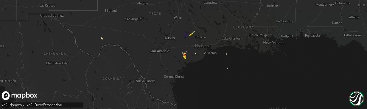
Hail Map on April 22, 2026
The weather event on April 22, 2026 includes Hail, Wind, and Tornado maps. 9 states and 120 cities were impacted and suffered possible damage. The total estimated number of properties impacted is 67,078.
Hail
Wind
Tornado
67,078
Estimated number of impacted properties by a 1.00" hail or larger2,357
Estimated number of impacted properties by a 1.75" hail or larger0
Estimated number of impacted properties by a 2.50" hail or largerStates Impacted by Hail Map on April 22, 2026
Storm reports
Texas
| Date | Description |
|---|---|
| 04/22/20265:58 PM CDT | Jackson county emergency manager reported large hail with at least 14 power poles downed over the area. |
| 04/22/20265:30 PM CDT | Local fire department reported hail... Ranging from quarter to approximately golf ball size... Over southern brazos county. |
South Dakota
| Date | Description |
|---|---|
| 04/22/20266:50 PM CDT | A local report indicates 61 MPH wind near 4 E Cactus Flat |
| 04/22/20266:45 PM CDT | Time estimated via radar. |
| 04/22/20266:40 PM CDT | A local report indicates 65 MPH wind near 3 NW Wasta |
| 04/22/20266:30 PM CDT | A local report indicates 68 MPH wind near 2 E Elm Springs |
| 04/22/20266:30 PM CDT | A local report indicates 70 MPH wind near 3 NW Wasta |
| 04/22/20266:25 PM CDT | A local report indicates 59 MPH wind near 3 NW Wasta |
| 04/22/20266:20 PM CDT | A local report indicates 62 MPH wind near 11 SSE Hereford |
| 04/22/20266:15 PM CDT | A local report indicates 58 MPH wind near Wasta |
| 04/22/20266:13 PM CDT | A local report indicates 68 MPH wind near 3 NNW Scenic |
| 04/22/20266:10 PM CDT | A local report indicates 76 MPH wind near 3 NW Wasta |
| 04/22/20266:05 PM CDT | A local report indicates 59 MPH wind near 3 NW Wasta |
| 04/22/20265:55 PM CDT | A local report indicates 74 MPH wind near 6 ESE Scenic |
| 04/22/20265:34 PM CDT | A local report indicates 67 MPH wind near 8 SSW Folsom |
| 04/22/20265:19 PM CDT | A local report indicates 58 MPH wind near 8 SSW Folsom |
| 04/22/20264:35 PM CDT | Mesonet station llms2 long lake 4nw |
| 04/22/20264:30 PM CDT | Power poles snapped due to wind. |
| 04/21/202611:15 PM CDT | Mesonet station llks2 eureka 13 ene. |
| 04/21/202611:15 PM CDT | Mesonet station 313 selby 5se |
| 04/21/20269:44 PM CDT | Mesonet station 50 herreid |
| 04/21/20269:39 PM CDT | A 10x10 outbuilding and gazebo were flattened by thunderstorm wind gusts. Time estimated via radar. |
| 04/21/20269:19 PM CDT | Mesonet station 313 selby 5se |
| 04/21/20269:09 PM CDT | Mesonet station 313 selby 5se |
| 04/21/20268:49 PM CDT | Mesonet station 313 selby 5se |
| 04/21/20268:45 PM CDT | Mesonet station 209 lowry |
| 04/21/20268:20 PM CDT | Mesonet station gwms2 gettysburg 14w |
| 04/21/20267:35 PM CDT | Mesonet station 332 okobojo |
| 04/21/20267:16 PM CDT | A local report indicates 60 MPH wind near 2 SW Bridger |
Montana
| Date | Description |
|---|---|
| 04/22/20266:00 PM CDT | Mesonet station mtm89 angela w. |
| 04/22/20265:54 PM CDT | Asos station kjdn jordan. |
| 04/22/20265:10 PM CDT | Rock springs n... Mt |
| 04/21/202610:55 PM CDT | Asos station kmls miles city. |
| 04/21/202610:00 PM CDT | Scobey nw. |
| 04/21/20269:58 PM CDT | Medicine lake... Mt. |
| 04/21/20269:35 PM CDT | Sher-wood airport... Mt. |
| 04/21/20269:30 PM CDT | Comertown turn-off mt-5 mp 13.4. |
| 04/21/20269:30 PM CDT | Navajo mt-5 16.7. |
| 04/21/20269:20 PM CDT | Bredette ne... Mt |
| 04/21/20269:10 PM CDT | 54g71 medicine lake w... Mt |
| 04/21/20268:58 PM CDT | Mesonet station mlkm8 medicine lake 1ese. |
| 04/21/20268:50 PM CDT | Montana mesonet station medm8 |
| 04/21/20268:20 PM CDT | Montana mesonet station ftkm8 |
| 04/21/20268:15 PM CDT | Mesonet station mtsvg savage mt-16 mp 29.5. |
| 04/21/20268:00 PM CDT | Mesonet station fw2498 badger creek. |
| 04/21/20267:55 PM CDT | Montana mesonet station parm8 |
| 04/21/20267:50 PM CDT | Mesonet station fw8536 savage. |
| 04/21/20267:50 PM CDT | Montana mesonet station crbm8 |
| 04/21/20267:48 PM CDT | Mesonet station ggwfp 2.4 e fort peck |
| 04/21/20267:45 PM CDT | Mesonet station mtlbt lambert mt-200 mp 45.0. |
| 04/21/20267:35 PM CDT | Corrects previous tstm wnd gst report from 9 ne vida. Montana mesonet station vdnm8 |
| 04/21/20267:15 PM CDT | Montana mesonet station vdwm8 |
| 04/21/20267:00 PM CDT | Montana mesonet station mtm87 |
Illinois
| Date | Description |
|---|---|
| 04/22/20265:25 PM CDT | [landspout] corrects previous landspout report from 5 ne donovan. Numerous pictures and videos of landspout tornado. First report was received at 5:23 pm and likely la |
California
| Date | Description |
|---|---|
| 04/21/20267:59 PM CDT | Nws hanford storm survey team found damage indicative of an ef-1 tornado with maximum winds at 110 mph. Video shows multiple large pieces of metal roofing material alof |
| 04/21/20267:09 PM CDT | Nws hanford storm survey team found damage indicative of an ef-1 tornado with peak winds of 95 mph. 2 hardwood tees snapped in half. Along tollhouse road... A barn was |
Ohio
| Date | Description |
|---|---|
| 04/22/20265:10 PM CDT | Hail covering ground. Max hailstone diameter is 1 inch. |
| 04/22/20265:09 PM CDT | A local report indicates 1.00 inch wind near Fostoria |
| 04/22/20265:09 PM CDT | Delayed report - ping pong size hail. |
| 04/22/20264:50 PM CDT | Delayed report. Quarter size hail reported between leipsic and ottawa. Time estimated via radar. |
| 04/22/20264:45 PM CDT | Delayed report. Dime to quarter size hail reported between leipsic and miller city on sr 613. Time estimated via radar. |
| 04/22/20264:42 PM CDT | Mping report. |
| 04/22/20264:41 PM CDT | A local report indicates 1.00 inch wind near 1 NW Minerva Park |
| 04/22/20264:37 PM CDT | A local report indicates 1.00 inch wind near 3 E Miller City |
| 04/22/20264:35 PM CDT | Delayed report. Time estimated via radar. |
| 04/22/20264:35 PM CDT | Quarter size hail reported at the intersection of cr 613 and road 12 se of miller city. Time estimated via radar. |
| 04/22/20264:10 PM CDT | Photos show 1.3 inch hail. |
| 04/22/20264:07 PM CDT | Photos show several 1 inch hail stones. |
| 04/22/20264:07 PM CDT | Average hail size .375 inches. |
| 04/22/20264:06 PM CDT | Range of hail sizes... Largest stones nickel to quarter sized. |
Indiana
| Date | Description |
|---|---|
| 04/22/20263:18 PM CDT | Time estimated by radar. |
| 04/22/20263:14 PM CDT | Report from mping: quarter |
| 04/22/20262:20 PM CDT | Photo on facebook showing hailstones ranging from dime to quarter size on sr 19 near the west 700 south. Time estimated via radar. |
Utah
| Date | Description |
|---|---|
| 04/22/20267:30 AM CDT | Mesonet station ut215 i-215 at i-80. |
North Dakota
| Date | Description |
|---|---|
| 04/21/202610:58 PM CDT | Ndawn station 10m wind gust measured 58 mph. |
| 04/21/202610:32 PM CDT | Ndawn 10m peak gust. |
| 04/21/202610:06 PM CDT | Ndawn 10m peak gust. |
| 04/21/202610:03 PM CDT | Ndawn station 10m wind gust measured 60 mph. |
| 04/21/20268:58 PM CDT | 10 m wind gust at ndawn station wishek 5 w. |
Cities Impacted by Hail Map on April 22, 2026
- Cherokee, IA
- Dolliver, IA
- Walkerton, IN
- Plymouth, IN
- Hillsdale, MI
- Reading, MI
- Quincy, MI
- Allen, MI
- North Webster, IN
- Argos, IN
- Tippecanoe, IN
- Rochester, IN
- Cromwell, IN
- Kimmell, IN
- Pierceton, IN
- Larwill, IN
- Bourbon, IN
- Mentone, IN
- Albion, IN
- Osseo, MI
- Pittsford, MI
- Akron, IN
- Claypool, IN
- Hudson, MI
- Waldron, MI
- Macy, IN
- Silver Lake, IN
- North Manchester, IN
- Alvordton, OH
- Pioneer, OH
- Camden, MI
- Roann, IN
- Warsaw, IN
- Laketon, IN
- West Unity, OH
- Boling, TX
- Damon, TX
- Wabash, IN
- Archbold, OH
- Guy, TX
- Peru, IN
- Wauseon, OH
- Napoleon, OH
- Plain City, OH
- Delaware, OH
- Powell, OH
- Dublin, OH
- Denver, IN
- Ridgeville Corners, OH
- Defiance, OH
- Columbus, OH
- Stryker, OH
- Hilliard, OH
- Hamler, OH
- Pataskala, OH
- Morenci, MI
- Fayette, OH
- Deshler, OH
- Miller City, OH
- Ottawa, OH
- Leipsic, OH
- Continental, OH
- Fremont, OH
- Galena, OH
- Westerville, OH
- Vickery, OH
- Clyde, OH
- Fort Stockton, TX
- Lewistown, OH
- Bloomdale, OH
- Garwood, TX
- Fostoria, OH
- Lakeview, OH
- Russells Point, OH
- Bellevue, OH
- Navasota, TX
- Huntsville, OH
- Belle Center, OH
- De Graff, OH
- College Station, TX
- Hallettsville, TX
- Kenton, OH
- Anderson, TX
- Gambier, OH
- Walhonding, OH
- Howard, OH
- Louise, TX
- Frazeysburg, OH
- Monroeville, OH
- Edna, TX
- Norwalk, OH
- Carroll, OH
- New London, OH
- Sycamore, OH
- Nevada, OH
- Bucyrus, OH
- North Fairfield, OH
- Bedias, TX
- Ganado, TX
- Findlay, OH
- Belvidere, SD
- Poplar, MT
- Okaton, SD
- Gonzales, TX
- Cost, TX
- Murdo, SD
- Gettysburg, SD
- Selby, SD
- Hoven, SD
- Merriman, NE
- Fort Pierre, SD
- Onida, SD
- Pierre, SD
- Orient, SD
- Lebanon, SD
- Rockham, SD
- Tolstoy, SD
- Onaka, SD
- Richville, MN
- Alvada, OH