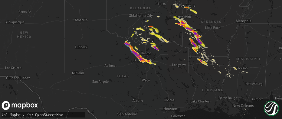
Hail Map on April 25, 2026
The weather event on April 25, 2026 includes Hail, Wind, and Tornado maps. 10 states and 461 cities were impacted and suffered possible damage. The total estimated number of properties impacted is 550,179.
Hail
Wind
Tornado
550,179
Estimated number of impacted properties by a 1.00" hail or larger193,408
Estimated number of impacted properties by a 1.75" hail or larger83,038
Estimated number of impacted properties by a 2.50" hail or largerStates Impacted by Hail Map on April 25, 2026
Storm reports
Oklahoma
| Date | Description |
|---|---|
| 04/25/20266:51 PM CDT | A local report indicates 1.75 inch wind near 5 NE Vinita |
| 04/25/20266:48 PM CDT | Report from mping: quarter |
| 04/25/20266:35 PM CDT | Observation from vinita mesonet. |
| 04/25/20266:33 PM CDT | Report from mping: quarter |
| 04/25/20266:13 PM CDT | Report from mping: quarter |
| 04/25/20266:12 PM CDT | A local report indicates 1.00 inch wind near 1 NNE Duncan |
| 04/25/20266:12 PM CDT | A local report indicates 2.00 inch wind near 4 E Heavener |
| 04/25/20266:12 PM CDT | Report from mping: quarter |
| 04/25/20266:06 PM CDT | Report from mping: quarter |
| 04/25/20266:05 PM CDT | Report from mping: quarter |
| 04/25/20265:52 PM CDT | A local report indicates 1.75 inch wind near 5 N Vanoss |
| 04/25/20265:35 PM CDT | A local report indicates 1.00 inch wind near 1 NW Heavener |
| 04/25/20265:33 PM CDT | A local report indicates 1.75 inch wind near Wister |
| 04/25/20265:30 PM CDT | Relayed via emergency manager. |
| 04/24/20269:22 PM CDT | A local report indicates 1.00 inch wind near Coleman |
| 04/24/20268:33 PM CDT | Report from mping: quarter |
| 04/24/20268:28 PM CDT | Report from mping: quarter |
| 04/24/20268:27 PM CDT | A local report indicates 1.25 inch wind near 5 E Reagan |
| 04/24/20268:14 PM CDT | A local report indicates a tornado near 4 SSE Mill Creek |
| 04/24/20268:06 PM CDT | Report from mping: quarter |
| 04/24/20268:05 PM CDT | Time estimated from radar. |
| 04/24/20268:02 PM CDT | A local report indicates 1.75 inch wind near 6 SSE Cameron |
| 04/24/20268:00 PM CDT | Social media report. |
| 04/24/20267:53 PM CDT | A local report indicates a tornado near 5 E Pauls Valley |
| 04/24/20267:50 PM CDT | Social media report with image. |
| 04/24/20267:50 PM CDT | Corrects previous report from 3wnw of ravia. Social media report with image. |
| 04/24/20267:49 PM CDT | A local report indicates a tornado near 4 ENE Hickory |
| 04/24/20267:44 PM CDT | A local report indicates 1.00 inch wind near 3 E Panama |
| 04/24/20267:40 PM CDT | A local report indicates 1.00 inch wind near 10 W Anderson |
| 04/24/20267:35 PM CDT | Social media report with image. |
| 04/24/20267:32 PM CDT | Corrects previous hail report from 4 wnw tiff city. Time estimated from radar. |
| 04/24/20267:26 PM CDT | Time estimated from radar. |
| 04/24/20267:21 PM CDT | Report from mping: quarter |
| 04/24/20267:19 PM CDT | Report from mping: quarter |
Louisiana
| Date | Description |
|---|---|
| 04/25/20264:47 AM CDT | Social media report with a photo of very large in western claiborne parish... Sw of the town of homer. |
| 04/25/20264:47 AM CDT | Corrects previous hail report from 7 wsw homer. Social media report with a photo of very large in western claiborne parish... Sw of the town of homer. |
| 04/25/20264:09 AM CDT | Few trees down along with roof damage to a couple of sheds. The roof was partially pealed back at the police jury building. |
| 04/25/20264:04 AM CDT | Hail of at least half dollar to ping pong size just west of the antioch community... Near the intersection of la-544 & la-151. |
| 04/25/20263:00 AM CDT | Large tree down just north of town. |
Virginia
| Date | Description |
|---|---|
| 04/25/20266:52 PM CDT | 2 trees knocked down along melon field rd. Time estimated from radar. |
| 04/25/20266:44 PM CDT | Tree knocked down along grays shop road. Time estimated from radar. |
Kansas
| Date | Description |
|---|---|
| 04/25/20266:59 PM CDT | Between colwich and maize. |
| 04/25/20266:51 PM CDT | Reported 2 inch hail near the pratt community college. Time estimated via radar. |
| 04/25/20266:50 PM CDT | Delayed report. Report from social media showed up to 2 inch hail measured up with a ruler. Time estimated via radar. |
| 04/25/20266:48 PM CDT | Pratt county em reported tennis ball sized hail near the pratt airport. |
| 04/25/20266:39 PM CDT | Broadcast media reported golf ball sized hail near pratt county airport. |
| 04/25/20266:38 PM CDT | Reported golf-ball sized hail near iuka. |
| 04/25/20266:30 PM CDT | Pratt county dispatch reported 75 mph winds. |
| 04/25/20266:30 PM CDT | Quarter-size hail. |
| 04/25/20266:06 PM CDT | Also hail up to nickel size nearly covered the ground. |
| 04/25/20265:57 PM CDT | A local report indicates 1.00 inch wind near 3 S Dillwyn |
| 04/25/20265:51 PM CDT | Delayed report. Personal ambient weather station nutrients_ag reported maximum wind gust of 65 mph. |
| 04/25/20265:26 PM CDT | A local report indicates 1.00 inch wind near 4 NE Zook |
| 04/25/20265:10 PM CDT | A local report indicates 1.00 inch wind near 1 N Rush Center |
| 04/25/20265:00 PM CDT | A local report indicates 1.25 inch wind near Rush Center |
| 04/25/20265:00 PM CDT | A local report indicates 1.00 inch wind near Rush Center |
| 04/25/20264:55 PM CDT | Social media report of ping pong ball sized hail on the south side of la crosse. |
| 04/25/20264:50 PM CDT | Corrects previous hail report from 2 wnw la crosse. |
| 04/25/20264:47 PM CDT | A local report indicates 1.50 inch wind near 1 NNW Frizell |
| 04/25/20264:05 PM CDT | A local report indicates 1.00 inch wind near 2 E McCracken |
| 04/25/20264:00 PM CDT | A local report indicates 1.25 inch wind near 2 WNW La Crosse |
| 04/25/20263:38 PM CDT | Hail covering the ground. Reported nickel size or slightly larger. Time estimated from radar. |
| 04/24/20269:05 PM CDT | Also wind gusts around 55 mph. |
| 04/24/20269:04 PM CDT | Two inch tree branches blown down. |
| 04/24/20268:58 PM CDT | 55-60 mph estimate. |
| 04/24/20268:05 PM CDT | Report from mping: quarter |
| 04/24/20267:54 PM CDT | A local report indicates 1.00 inch wind near 1 W Tyro |
| 04/24/20267:49 PM CDT | Hail up to quarter size covered the ground. |
| 04/24/20267:46 PM CDT | Report from mping. |
| 04/24/20267:44 PM CDT | Report from mping. |
| 04/24/20267:36 PM CDT | Report from mping. |
| 04/24/20267:31 PM CDT | A local report indicates 1.50 inch wind near 3 WNW Downtown Wichita |
| 04/24/20267:30 PM CDT | Near 13th and west. Hail sizes ranged from quarters to golfballs. Time estimated from radar. |
| 04/24/20267:28 PM CDT | Near rock and harry. |
| 04/24/20267:25 PM CDT | Report half-dollar sized hail near isabel wetlands wildlife area. |
| 04/24/20267:24 PM CDT | Near 21st and ridge. |
| 04/24/20267:17 PM CDT | Near 119th and 29th. |
| 04/24/20267:14 PM CDT | Near 119th and 21st. |
| 04/24/20267:04 PM CDT | Report from mping. |
| 04/24/20267:04 PM CDT | Near 199th and 29th street north. |
| 04/24/20267:00 PM CDT | Social media report of half-dollar sized hail at pratt county lake. |
Mississippi
| Date | Description |
|---|---|
| 04/25/20268:00 AM CDT | Numerous trees from 6-24 inches and large branches down in area of hwy 90/courthouse rd. |
| 04/25/20266:45 AM CDT | Scattered trees were reported down by the lincoln county em. |
| 04/25/20266:27 AM CDT | Scattered trees were reported down by the lincoln county em. |
Texas
| Date | Description |
|---|---|
| 04/25/20266:53 PM CDT | A local report indicates a tornado near 5 NE Windthorst |
| 04/25/20266:46 PM CDT | A local report indicates a tornado near 4 NE Windthorst |
| 04/25/20266:18 PM CDT | Social media report with image. |
| 04/25/20266:18 PM CDT | Report from mping: golf ball |
| 04/25/20266:17 PM CDT | Report from mping: hen egg |
| 04/25/20266:06 PM CDT | Time estimated. |
| 04/25/20266:04 PM CDT | Report from mping: golf ball |
| 04/25/20266:02 PM CDT | A local report indicates a tornado near 8 N Archer City |
| 04/25/20265:56 PM CDT | A local report indicates 1.50 inch wind near 1 E Lakeside City |
| 04/25/20265:54 PM CDT | Report from mping: quarter |
| 04/25/20265:50 PM CDT | A local report indicates 3.00 inch wind near 6 SSW Lakeside City |
| 04/25/20265:48 PM CDT | Report from mping: quarter |
| 04/25/20265:42 PM CDT | A local report indicates 2.00 inch wind near 5 SE Holliday |
| 04/25/20265:30 PM CDT | A local report indicates 1.00 inch wind near 4 NNW Lakeside City |
| 04/25/20265:25 PM CDT | A local report indicates 1.00 inch wind near 2 WSW Wichita Falls |
| 04/25/20266:50 AM CDT | Ping pong ball size hail reported at the intersection of fm 981 and hwy 69. |
| 04/25/20266:42 AM CDT | Golfball size hail in the city of trenton. |
| 04/25/20266:40 AM CDT | Delayed report. Pictures showed hail stones around 4 inches in diameter in trenton. Time estimated by radar. |
| 04/25/20266:30 AM CDT | Golfball size hail reported in downtown whitewright. |
| 04/25/20266:23 AM CDT | Corrects previous hail report from 1 ese tom bean. Delayed report. Photo showed hail stones between 2 and 2.25 inches in diameter just east of tom bean. Time estimated |
| 04/25/20266:21 AM CDT | Ping pong ball size hail in tom bean. |
| 04/25/20266:18 AM CDT | 3 and a half inch hail reported at the intersection of marlow road and rochelle canyon road. |
| 04/25/20265:58 AM CDT | Quarter size hail reported near the sherman municipal airport. |
| 04/25/20265:55 AM CDT | Quarter size hail reported near lamar and us 75. |
| 04/25/20265:54 AM CDT | Quarter size hail reported at cherry street park. |
| 04/25/20265:50 AM CDT | Quarter size hail reported in south sherman. |
| 04/25/20264:34 AM CDT | Quarter sized hail reported near hwy 69 covering 5 percent of the ground. |
| 04/25/20264:32 AM CDT | Quarter sized hail reported 1 mile northwest of downtown denison. |
| 04/25/20264:27 AM CDT | Quarter sized hail reported in downtown pottsboro. |
| 04/25/20261:59 AM CDT | Report from mping. |
| 04/25/20261:42 AM CDT | Krbd. |
| 04/25/20261:26 AM CDT | A local report indicates 1.50 inch wind near 1 S Cockrell Hill |
| 04/25/20261:20 AM CDT | Krbd. |
| 04/25/20261:06 AM CDT | A local report indicates 1.00 inch wind near 2 SSW Arlington |
| 04/25/20261:02 AM CDT | Report from mping. |
| 04/25/20261:02 AM CDT | A local report indicates 1.00 inch wind near 3 NNE Pantego |
| 04/25/202612:59 AM CDT | Spotter network report. |
| 04/25/202612:58 AM CDT | Delayed report. Received a photo of 2 inch hail near lake arlington. Time estimated by radar. |
| 04/25/202612:56 AM CDT | Report from mping. |
| 04/25/202612:56 AM CDT | A local report indicates 2.50 inch wind near 4 WSW Cockrell Hill |
| 04/25/202612:56 AM CDT | Report from mping. |
| 04/25/202612:56 AM CDT | Report from mping. |
| 04/25/202612:55 AM CDT | Report from mping. |
| 04/25/202612:51 AM CDT | Delayed report. Facebook photo shows large hail estimated to be up to 3 inches in diameter around dallas baptist university. Windows of cars were blown out. Time estima |
| 04/25/202612:46 AM CDT | Report from mping. |
| 04/25/202612:46 AM CDT | Report from mping. |
| 04/25/202612:39 AM CDT | Nws fort worth office. |
| 04/25/202612:36 AM CDT | A local report indicates 1.00 inch wind near Grand Prairie |
| 04/25/202612:35 AM CDT | Social media photo. Time estimated. |
| 04/25/202612:30 AM CDT | Emailed photo. |
| 04/25/202612:18 AM CDT | Knfw. |
| 04/24/202611:48 PM CDT | A local report indicates 1.25 inch wind near 1 ESE River Oaks |
| 04/24/202611:46 PM CDT | A local report indicates 1.00 inch wind near 1 N Pelican Bay |
| 04/24/202611:30 PM CDT | Report from mping. |
| 04/24/202611:28 PM CDT | A local report indicates 1.00 inch wind near Lake Worth |
| 04/24/202611:16 PM CDT | Report from mping. |
| 04/24/202611:15 PM CDT | Report from mping. |
| 04/24/202611:13 PM CDT | Report from mping. |
| 04/24/202611:03 PM CDT | Report from mping. |
| 04/24/202611:03 PM CDT | Report from mping. |
| 04/24/202611:02 PM CDT | Report from mping. |
| 04/24/202610:59 PM CDT | Report from mping. |
| 04/24/202610:59 PM CDT | Social media photo. |
| 04/24/202610:51 PM CDT | Report from mping. |
| 04/24/202610:51 PM CDT | Report from mping. |
| 04/24/202610:51 PM CDT | Spotter network report. |
| 04/24/202610:51 PM CDT | Social media photo. |
| 04/24/202610:50 PM CDT | Emailed photo. Time estimated. |
| 04/24/202610:50 PM CDT | Report from mping. |
| 04/24/202610:49 PM CDT | Report from mping. |
| 04/24/202610:49 PM CDT | Report from mping. |
| 04/24/202610:47 PM CDT | A local report indicates 1.75 inch wind near 3 WSW White Settlement |
| 04/24/202610:43 PM CDT | Delayed report. Facebook photo showed golf ball sized hail in lakeside near silver creek road and confederate parkway. Time estimated by radar. |
| 04/24/202610:41 PM CDT | Report from mping. |
| 04/24/202610:39 PM CDT | A local report indicates 1.00 inch wind near 2 N White Settlement |
| 04/24/202610:39 PM CDT | A local report indicates 1.00 inch wind near 2 NNW Eagle Mountain |
| 04/24/202610:30 PM CDT | Report from mping. |
| 04/24/202610:10 PM CDT | Delayed report. Social media report of 3 inch hailstone measured near azle. |
| 04/24/202610:04 PM CDT | Report from mping. |
| 04/24/202610:01 PM CDT | Delayed report. Damage was reported around old springtown rd and midway rd... Out to fm 51. A powerline was wrapped around a car... Along with multiple trees down. A mo |
| 04/24/20269:50 PM CDT | Report of damage to multiple residences. Numerous roads blocked by down trees. Time estimated. |
| 04/24/20269:48 PM CDT | Location approximated. |
| 04/24/20269:47 PM CDT | Delayed report. Facebook photos showed damage to a home on goshen road. Garage collapsed... Greenhouse missing... And the home sustained window... Front porch... And ro |
| 04/24/20269:45 PM CDT | Report of damaged rv with person trapped inside and successfully rescued. Many medium and large trees down. Damage to metal structures. Time estimated. |
| 04/24/20269:45 PM CDT | Report of vehicle blown off road into ditch with trapped occupants. No injuries. Time estimated. |
| 04/24/20269:43 PM CDT | Report from mping. |
| 04/24/20269:40 PM CDT | Numerous reports of downed trees power lines and sheet metal debris along tx 199 between agnes and springtown. Time estimated. |
| 04/24/20269:40 PM CDT | Spotter network report. |
| 04/24/20269:40 PM CDT | Delayed report. Facebook photos show trees down and roof damage to a home on agnes circle... West of springtown. Time estimated by radar. |
| 04/24/20269:35 PM CDT | Social media post. Unsecured manufactured home toppled over by wind and was upside down. Time estimated. |
| 04/24/20269:28 PM CDT | Report from mping. |
| 04/24/20269:10 PM CDT | Report from mping. |
| 04/24/20269:00 PM CDT | A local report indicates 1.75 inch wind near 6 SSW Paradise |
| 04/24/20268:49 PM CDT | A local report indicates 1.00 inch wind near 2 WNW Bridgeport |
| 04/24/20268:47 PM CDT | A local report indicates 2.75 inch wind near Runaway Bay |
| 04/24/20268:43 PM CDT | A local report indicates 2.00 inch wind near Runaway Bay |
| 04/24/20268:36 PM CDT | Report from mping. |
| 04/24/20268:26 PM CDT | Report from mping. |
| 04/24/20268:22 PM CDT | A local report indicates 1.00 inch wind near 8 NE Jacksboro |
| 04/24/20268:12 PM CDT | Delayed report. Emergency manager reported a downed tree on coca cola ranch rd northeast of jacksboro. Time estimated by radar. |
| 04/24/20268:12 PM CDT | Delayed report. Emergency manager reported downed powerlines and damaged homes and trees northeast of jacksboro. Time estimated by radar. |
| 04/24/20268:10 PM CDT | A local report indicates 2.00 inch wind near 11 NE Jacksboro |
| 04/24/20268:04 PM CDT | Delayed report. Emergency manager reported tree damage on crooke creek rd northeast of jacksboro. Time estimated by radar. |
| 04/24/20267:57 PM CDT | Multiple trees and power poles snapped. |
| 04/24/20267:50 PM CDT | Roof caved in on a vacant house. Time estimated. |
| 04/24/20267:50 PM CDT | Delayed report. Emergency manager reported an overturned trailer northwest of jacksboro. Time estimated by radar. |
| 04/24/20267:19 PM CDT | Two tornadoes on the ground. |
Arkansas
| Date | Description |
|---|---|
| 04/25/20269:28 AM CDT | A very large hailstone was placed on a flat surface with a ruler next to it. The stone exceeds 4 inches in diameter but is less than 5 inches in diameter. |
| 04/25/20261:25 AM CDT | Emergency manager reports golf ball size hail at holly mound just north of the town of stamps. |
| 04/25/20261:24 AM CDT | Emergency manager reports quarter size hail in lewisville... Arkansas. |
| 04/25/20261:00 AM CDT | A tree was blown down and fell on a house. |
| 04/25/202612:55 AM CDT | The metal roof of a business was almost entirely removed. |
| 04/25/202612:21 AM CDT | Social media report of approx. Egg-sized hail in hope. |
| 04/24/202611:44 PM CDT | Reports from social media of baseball size hail in hope... Arkansas. |
| 04/24/202611:35 PM CDT | A local report indicates 1.00 inch wind near Waldron |
| 04/24/202611:33 PM CDT | Walnut sized hail reported just north of washington... Arkansas. |
| 04/24/202611:19 PM CDT | Public report of golf ball to baseball sized hail sw of gurdon. |
| 04/24/202611:08 PM CDT | Report of golf ball size hail relayed to hempstead county 911 call center from the town of ozan... Ar. |
| 04/24/202610:57 PM CDT | Hail |
| 04/24/202610:50 PM CDT | Multiple trees down and some property damage reported west of nashville... Ar. |
| 04/24/202610:46 PM CDT | Mping report of ping pong ball size hail north of nashville... Ar. |
| 04/24/202610:45 PM CDT | A local report indicates 1.25 inch wind near 1 SW Antoine |
| 04/24/202610:30 PM CDT | Tree branches blown onto a a power line. |
| 04/24/20269:52 PM CDT | Ham radio operator relayed report of quarter sized hail from ozone fire dept. Time estimated from radar. |
| 04/24/20269:52 PM CDT | Ham radio operator reports quarter sized hail 5 miles west of arkadelphia. Time estimated from radar. |
| 04/24/20269:30 PM CDT | Broadcast media shared a picture of at least tennis ball sized hail near point cedar. Time estimated from radar. |
| 04/24/20269:28 PM CDT | Increased hail size based on additional images of the hailstone. Broadcast media shared pictures of at least tennis ball sized hail in alpine. Time estimated from radar |
| 04/24/20269:28 PM CDT | Broadcast media shared pictures of at least tennis ball sized hail in alpine. Time estimated from radar. |
| 04/24/20269:17 PM CDT | Increased hail size based on additional images of the hailstone. Broadcast media shared pictures of at least tennis ball sized hail in amity. Police dispatch from amity |
| 04/24/20269:17 PM CDT | Broadcast media shared pictures of at least tennis ball sized hail in amity. Police dispatch from amity also reports damaged windshields in town. Time estimated from ra |
| 04/24/20269:05 PM CDT | Updates previous hail report from welsh. Montgomery co sheriff dept report damaged windshields to patrol cars... And damage to roofs from the public. Montgomery co sher |
| 04/24/20269:05 PM CDT | Pike co. Em reports tree and powerline damage near baker and bethel roads. Time estimated from radar. |
| 04/24/20269:05 PM CDT | Montgomery co sheriff deputy reported baseball sized hail between glenwood and bonnerdale on us70 in southeast montgomery co. Time and location estimated from radar. |
| 04/24/20269:05 PM CDT | Ham radio operator reports between golf ball to baseball sized hail in glenwood. Time estimated from radar. |
| 04/24/20269:05 PM CDT | Numerous trees uprooted in the area. |
| 04/24/20269:03 PM CDT | Public report of quarter sized hail just east of glenwood. Time estimated by radar. |
| 04/24/20268:47 PM CDT | Report from mping: hen egg |
| 04/24/20268:38 PM CDT | Ham radio operator reports quarter sized hail in hon. Time estimated from radar. |
| 04/24/20268:37 PM CDT | Ham radio operator reports quarter sized hail in norman. Time estimated from radar. |
| 04/24/20268:20 PM CDT | Montgomery co fire chief reports golf ball sized hail south of mount ida. Time estimated from radar. |
| 04/24/20268:12 PM CDT | Time estimated from radar. |
| 04/24/20268:10 PM CDT | Time estimated from radar. |
| 04/24/20268:04 PM CDT | Relayed from hartford fd via ham. |
| 04/24/20267:45 PM CDT | Ham radio operator reports quarter sized hail. Time and location estimated from radar. |
| 04/24/20267:44 PM CDT | Updates previous hail report from 1 wsw huddleston. Montgomery co. Fire chief reports golf ball sized hail near south side rd. Damage to roofs and vehicles also occurre |
| 04/24/20267:44 PM CDT | Montgomery co. Fire chief reports golf ball sized hail near south side rd. Time estimated from radar. |
| 04/24/20267:14 PM CDT | Public report of quarter sized hail. Time estimated from radar. |
Nebraska
| Date | Description |
|---|---|
| 04/25/20265:56 PM CDT | Report from mping: quarter |
| 04/25/20264:31 PM CDT | Highway 34 was closed from highway 81 west to road j due to downed power lines. Time matched up with time of awos report of 68 mph. |
| 04/25/20264:31 PM CDT | Corrects previous non-tstm wnd gst report from york airport. Report from york airport. Exact time estimated from radar. |
| 04/25/20263:34 PM CDT | [landspout] social media video of a brief landspout in open field sw of bradshaw. |
| 04/24/20269:55 PM CDT | Quarter to golf ball sized hail. |
| 04/24/20268:55 PM CDT | A local report indicates 1.50 inch wind near Beatrice |
Cities Impacted by Hail Map on April 25, 2026
- Minden, NE
- Lebanon, KS
- Red Cloud, NE
- Campbell, NE
- Guide Rock, NE
- Blue Hill, NE
- Lawrence, NE
- Hastings, NE
- Glenvil, NE
- Inland, NE
- Trumbull, NE
- Gaylord, KS
- Cedar, KS
- Brownell, KS
- Portis, KS
- McCracken, KS
- Keysville, VA
- Charlotte Court House, VA
- Giltner, NE
- Harvard, NE
- Aurora, NE
- Henderson, NE
- Downs, KS
- La Crosse, KS
- York, NE
- Bradshaw, NE
- Hampton, NE
- Larned, KS
- Esbon, KS
- Benedict, NE
- Alexander, KS
- Rush Center, KS
- Nekoma, KS
- Wister, OK
- Red Oak, OK
- Bison, KS
- Stromsburg, NE
- Gresham, NE
- Waco, NE
- Cawker City, KS
- McCool Junction, NE
- Glen Elder, KS
- Wichita Falls, TX
- Iowa Park, TX
- Fairmont, NE
- Beloit, KS
- Holliday, TX
- Shickley, NE
- Ulysses, NE
- Utica, NE
- Howe, OK
- Sheppard Afb, TX
- Heavener, OK
- Poteau, OK
- Langston, AL
- Keota, OK
- Stigler, OK
- Randall, KS
- Stratford, OK
- Ada, OK
- Macksville, KS
- Delaware, OK
- Seward, NE
- Staplehurst, NE
- Belpre, KS
- Winfield, KS
- Bee, NE
- Cedar Vale, KS
- Rose, OK
- Salina, OK
- Fyffe, AL
- Section, AL
- Sedan, KS
- Geneva, NE
- Strang, NE
- Exeter, NE
- Temple, OK
- Otis, KS
- Garfield, KS
- Beaver Crossing, NE
- Ohiowa, NE
- Bruning, NE
- Burden, KS
- Cambridge, KS
- Jamestown, KS
- Concordia, KS
- Hastings, OK
- Comanche, OK
- Waurika, OK
- Simpson, KS
- Colwich, KS
- Andale, KS
- Lenapah, OK
- Waldron, AR
- Bokoshe, OK
- Goehner, NE
- Pawnee Rock, KS
- Friend, NE
- Cordova, NE
- Wichita, KS
- Vinita, OK
- Maize, KS
- Belvidere, NE
- Mena, AR
- St John, KS
- Byers, KS
- Iuka, KS
- Henrietta, TX
- Scotland, TX
- Duncan, OK
- Bluejacket, OK
- Welch, OK
- Pratt, KS
- Dorchester, NE
- Tobias, NE
- Milligan, NE
- Alexandria, NE
- Milford, NE
- Grenola, KS
- Cameron, OK
- Shady Point, OK
- Longton, KS
- Porum, OK
- Turon, KS
- Cunningham, KS
- Glasco, KS
- Delphos, KS
- Daykin, NE
- Marlow, OK
- Havana, KS
- Afton, OK
- Windthorst, TX
- Rush Springs, OK
- Lindsay, OK
- Foster, OK
- Maysville, OK
- Stonewall, OK
- Aurora, KS
- Boles, AR
- Hartford, AR
- Moline, KS
- Western, NE
- Fairbury, NE
- Garland, NE
- Centre, AL
- Roff, OK
- Elk City, KS
- Independence, KS
- Sawyer, KS
- Isabel, KS
- Miami, OK
- Fairland, OK
- Swanton, NE
- Plymouth, NE
- Peru, KS
- Caney, KS
- Niotaze, KS
- Bellevue, TX
- Fitzhugh, OK
- Allen, OK
- Tupelo, OK
- Parks, AR
- Medicine Lodge, KS
- Jansen, NE
- De Witt, NE
- Wynnewood, OK
- Crete, NE
- Wyandotte, OK
- Mount Hope, KS
- Bowie, TX
- Valley Center, KS
- Goddard, KS
- Nashville, KS
- Centrahoma, OK
- Andover, KS
- Fittstown, OK
- Oden, AR
- Mount Ida, AR
- Pauls Valley, OK
- Grove, OK
- Anderson, MO
- Tiff City, MO
- Goodman, MO
- Seneca, MO
- Miltonvale, KS
- Beatrice, NE
- Coffeyville, KS
- Tishomingo, OK
- Jacksboro, TX
- Dearing, KS
- Elmore City, OK
- South West City, MO
- Spiro, OK
- Zenda, KS
- Coalgate, OK
- Pickrell, NE
- Wilber, NE
- Cortland, NE
- Clatonia, NE
- Lincoln, AR
- Prairie Grove, AR
- Tyro, KS
- Mill Creek, OK
- Hackett, AR
- Mcconnell Afb, KS
- Paoli, OK
- Farmington, AR
- Fayetteville, AR
- West Fork, AR
- Copan, OK
- Clay Center, KS
- Norman, AR
- Bridgeport, TX
- Chico, TX
- Wann, OK
- S Coffeyville, OK
- Derby, KS
- Liberty, KS
- Coats, KS
- Mansfield, AR
- Milburn, OK
- Fort Smith, AR
- Pocola, OK
- Pencil Bluff, AR
- Huntington, AR
- Winslow, AR
- Elkins, AR
- Wapanucka, OK
- Macomb, OK
- Wanette, OK
- Minneapolis, KS
- Byars, OK
- Sunset, TX
- Tecumseh, OK
- Caddo Gap, AR
- Bonnerdale, AR
- Lexington, OK
- Adams, NE
- Firth, NE
- Coleman, OK
- Glenwood, AR
- Paradise, TX
- Alvord, TX
- Atoka, OK
- Kenefic, OK
- Perrin, TX
- Poolville, TX
- Wakefield, KS
- Locust Grove, OK
- Amity, AR
- Colcord, OK
- Boyd, TX
- Ozark, AR
- Combs, AR
- Caddo, OK
- Royal, AR
- Rhome, TX
- Springtown, TX
- Caney, OK
- Hulbert, OK
- Peggs, OK
- Oark, AR
- Pettigrew, AR
- Decatur, TX
- Okemah, OK
- Sulphur, OK
- Azle, TX
- Newark, TX
- Fort Worth, TX
- Weatherford, TX
- Elk Creek, NE
- Tecumseh, NE
- Steinauer, NE
- Tahlequah, OK
- Weleetka, OK
- Muskogee, OK
- Kansas, OK
- Stilwell, OK
- Table Rock, NE
- Proctor, OK
- Clarksville, AR
- Ozone, AR
- Arkadelphia, AR
- Johnson, NE
- Humboldt, NE
- Milford, KS
- Riley, KS
- Bokchito, OK
- Lane, OK
- Bennington, OK
- Kirby, AR
- Lewiston, NE
- Canehill, AR
- Fort Riley, KS
- Delight, AR
- Greenwood, AR
- Okolona, AR
- Bismarck, AR
- Midland, AR
- Aledo, TX
- Boswell, OK
- Newhope, AR
- Nashville, AR
- Naval Air Station Jrb, TX
- Dierks, AR
- Antoine, AR
- Gans, OK
- Ozan, AR
- Leon, OK
- McCaskill, AR
- Mineral Springs, AR
- Gurdon, AR
- Booneville, AR
- Washington, AR
- Columbus, AR
- Hope, AR
- Donaldson, AR
- Hugo, OK
- Muenster, TX
- Saint Jo, TX
- Prescott, AR
- Haltom City, TX
- Emmet, AR
- Bluff City, AR
- Chidester, AR
- Langley, AR
- Umpire, AR
- Arlington, TX
- Kennedale, TX
- Hurst, TX
- North Richland Hills, TX
- Haslet, TX
- Grant, OK
- Rosston, AR
- Murfreesboro, AR
- Soper, OK
- Grand Prairie, TX
- Bedford, TX
- Camden, AR
- Euless, TX
- Buckner, AR
- Arthur City, TX
- Dallas, TX
- Fulton, AR
- Sims, AR
- Story, AR
- Powderly, TX
- Cedar Hill, TX
- Duncanville, TX
- Burneyville, OK
- Desoto, TX
- Stamps, AR
- Lewisville, AR
- Texarkana, AR
- Loco, OK
- Healdton, OK
- Stephens, AR
- Lancaster, TX
- Mount Holly, AR
- Hampton, AR
- Willisville, AR
- Waldo, AR
- Louann, AR
- Smackover, AR
- Magnolia, AR
- Red Oak, TX
- Wilson, OK
- Emerson, AR
- El Dorado, AR
- Gainesville, TX
- Overbrook, OK
- Junction City, AR
- Ferris, TX
- Wilmer, TX
- Marietta, OK
- Lillie, LA
- Summerfield, LA
- Haynesville, LA
- Ringling, OK
- Thackerville, OK
- Strong, AR
- Taylor, AR
- Spearsville, LA
- Graham, OK
- Seagoville, TX
- Kaufman, TX
- Scurry, TX
- Springer, OK
- Ratliff City, OK
- Bernice, LA
- Huttig, AR
- Farmerville, LA
- Marion, LA
- Whitesboro, TX
- Downsville, LA
- Homer, LA
- Sterlington, LA
- Tallulah, LA
- Athens, LA
- Arcadia, LA
- Monroe, LA
- Calhoun, LA
- West Monroe, LA
- Edwards, MS
- Eros, LA
- Simsboro, LA
- Pottsboro, TX
- Rayville, LA
- Dubach, LA
- Sherman, TX
- Ruston, LA
- Denison, TX
- Mangham, LA
- Raymond, MS
- Utica, MS
- Columbia, LA
- Cotton Valley, LA
- Shongaloo, LA
- Minden, LA
- Vicksburg, MS
- Grambling, LA
- Winnsboro, LA
- Ardmore, OK
- Madill, OK
- Baskin, LA
- Yazoo City, MS
- Lockney, TX
- Wisner, LA
- Gilbert, LA
- Colbert, OK
- Lisbon, LA
- Gibsland, LA
- Saint Joseph, LA
- Newellton, LA
- Flora, MS
- Cartwright, OK
- Saint Paul, AR
- Bells, TX
- Port Gibson, MS
- Lorman, MS
- Florence, MS
- Howe, TX
- Fayette, MS
- Natchez, MS
- Whitewright, TX
- Braxton, MS
- Pattison, MS
- Harrisville, MS
- Savoy, TX
- Tom Bean, TX
- Bonham, TX
- Mendenhall, MS
- Trenton, TX
- Randolph, TX
- Leonard, TX
- Van Alstyne, TX
- Ector, TX
- Jefferson, TX
- Dighton, KS
- Celeste, TX
- Mize, MS