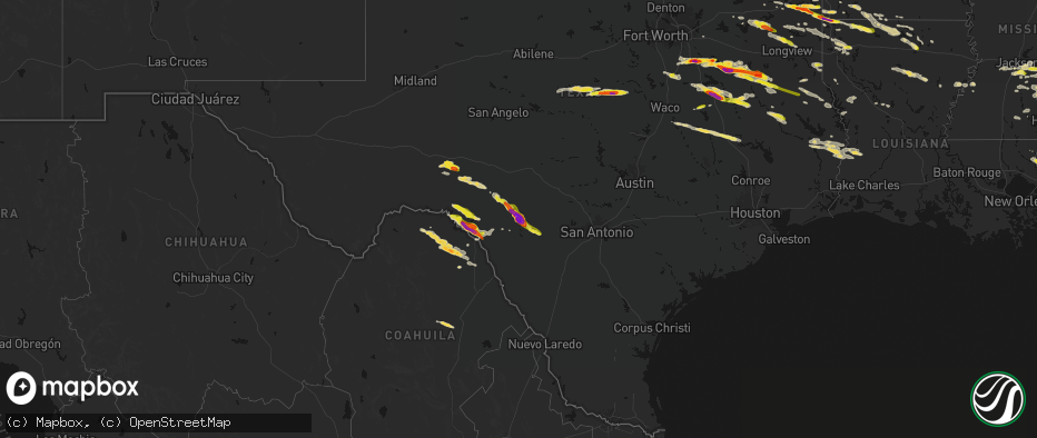
Hail Map on April 29, 2026
The weather event on April 29, 2026 includes Hail, Wind, and Tornado maps. 9 states and 335 cities were impacted and suffered possible damage. The total estimated number of properties impacted is 109,489.
Hail
Wind
Tornado
109,489
Estimated number of impacted properties by a 1.00" hail or larger36,103
Estimated number of impacted properties by a 1.75" hail or larger2,826
Estimated number of impacted properties by a 2.50" hail or largerStates Impacted by Hail Map on April 29, 2026
Storm reports
South Carolina
| Date | Description |
|---|---|
| 04/29/20266:36 AM CDT | The national weather service received a picture showing hail to the size of quarters near cainhoy. Most of the hail was smaller... But a few pieces to quarter size were |
Alabama
| Date | Description |
|---|---|
| 04/28/202611:49 PM CDT | A tree was knocked down into the roadway at the sharp curve near pine burr. |
| 04/28/202611:45 PM CDT | A tree was knocked down at the intersection of east parker road and mt. Tabor road. |
| 04/28/202611:33 PM CDT | A large tree was knocked down at the intersection of west lacon road and state crusher road. |
| 04/28/202610:15 PM CDT | Several trees were knocked down around a cul-de-sac on stonehenge place with a couple falling on homes. |
North Carolina
| Date | Description |
|---|---|
| 04/28/20269:48 PM CDT | Thousand power outages from trees on powerlines. |
| 04/28/20269:44 PM CDT | Report from mping: quarter |
| 04/28/20269:44 PM CDT | One inch hail measured near carrboro. |
| 04/28/20269:35 PM CDT | Several hundred power outages from trees down on powerlines. |
| 04/28/20269:30 PM CDT | Hundred power outages from trees on powerlines. |
| 04/28/20269:12 PM CDT | Picture passed along via social media shows a hail stone ranging from 1 to 1.5 inches. Time and approximate location estimated from radar. |
| 04/28/20269:10 PM CDT | A local report indicates 1.00 inch wind near Mebane |
| 04/28/20268:52 PM CDT | 1 inch hail observed near locust... Nc. |
| 04/28/20268:48 PM CDT | Hundred power outages from trees down on power lines. |
| 04/28/20268:45 PM CDT | Hundred power outages reported due to trees on powerlines. |
| 04/28/20268:30 PM CDT | Tree down near intersection of mizpah church road and nc-87. Time is estimated from radar. |
| 04/28/20268:18 PM CDT | Tree down on lawndale drive in reidsville... Nc. Time is estimated from radar. |
| 04/28/20268:08 PM CDT | One tree down. Time adjusted with radar. |
| 04/28/20267:50 PM CDT | Tree down near intersection of hen road and nc-770. Time is estimated from radar. |
Virginia
| Date | Description |
|---|---|
| 04/28/20268:26 PM CDT | Six to ten trees down. Time estimated by radar. |
Arkansas
| Date | Description |
|---|---|
| 04/29/202612:44 PM CDT | Report of quarter sized hail at 306 s elm st in emerson. |
| 04/29/202611:43 AM CDT | Half dollar sized hail reported at three states marker in texas. |
| 04/29/202611:43 AM CDT | Half dollar sized hail reported at three states. |
| 04/29/202611:37 AM CDT | Quarter to hail dollar sized hail in ravanna. Video relayed by broadcast media. |
Texas
| Date | Description |
|---|---|
| 04/29/20266:52 PM CDT | Report from mping hen egg |
| 04/29/20266:51 PM CDT | Report from mping hen egg |
| 04/29/20266:39 PM CDT | Report from mping quarter |
| 04/29/20266:36 PM CDT | Report from mping quarter |
| 04/29/20266:25 PM CDT | Media partner shared report of ~1.25 inch hail in jacksonville... Tx. West of 69 off hwy 135. |
| 04/29/20264:54 PM CDT | Reports from broadcast media of quarter size to golf ball size hail around bullard. Quarter size hail was reported east of us 69 along fm 344. |
| 04/29/20264:52 PM CDT | 911 call center recived a report of a tree down on fm 699 near carthage. |
| 04/29/20264:40 PM CDT | Report from mping: golf ball |
| 04/29/20264:31 PM CDT | Report from mping: half dollar |
| 04/29/20264:28 PM CDT | Amateur radio reports quarter sized hail in new york texas. |
| 04/29/20264:23 PM CDT | Quarter sized hail reported by amateur radio 3 miles nw of larue. |
| 04/29/20264:10 PM CDT | Report from mping: golf ball |
| 04/29/20264:08 PM CDT | Social media photos and videos showed up to tennis ball size hail in parts of athens. |
| 04/29/20263:34 PM CDT | Social media video of hail ranging from quarters to golf balls falling in seven points. Time estimated by radar. |
| 04/29/20263:31 PM CDT | Amateur radio reported quarter size hail 3 miles sw of mabank. |
| 04/29/20263:27 PM CDT | Amateur radio reported quarter size hail 1 mi south of seven points. |
| 04/29/20263:06 PM CDT | Amateur radio reported mostly quarter size hail with some larger size up to ping-pong ball. |
| 04/29/20262:36 PM CDT | Emergency manager reported 1.5 inch hail at the ennis public safety facility. |
| 04/29/20262:34 PM CDT | Social media photo on x showed 2.5 inch hail in ennis. |
| 04/29/20262:05 PM CDT | Reports of quarter size hail in judson. |
| 04/29/20262:05 PM CDT | Reports of half dollar to ping pong size hail just north of judson. |
| 04/29/20261:07 PM CDT | Social media report of approx. Ping pong ball sized hail in marietta. |
| 04/29/202612:08 PM CDT | Social media report of approx. Quarter sized hail in winnsboro. |
| 04/29/202611:16 AM CDT | Social media report of golf ball sized hail in douglassville. |
| 04/29/202610:56 AM CDT | Corrects previous hail report from marietta. Social media report of approx. Ping pong ball sized hail in marietta. |
| 04/28/202610:44 PM CDT | Media partner shared report of quarter-size hailstones along hwy 103 w in west lufkin. |
| 04/28/202610:23 PM CDT | Via facebook. |
| 04/28/202610:21 PM CDT | Report of numerous hail stones size of golf balls via phone call to the office. |
| 04/28/202610:00 PM CDT | Public report of hail to golf ball size off spur 406 on the north side of lake amistad. |
| 04/28/20269:25 PM CDT | Report from mping: half dollar |
| 04/28/20268:57 PM CDT | A local report indicates 1.00 inch wind near 2 SW Midway |
| 04/28/20268:55 PM CDT | Numerous reports of pea to golf ball size hail on the east side of fairfield. |
| 04/28/20268:50 PM CDT | Golf ball size hail reported at 460 hwy 75 north. |
| 04/28/20268:10 PM CDT | A local report indicates 1.00 inch wind near 2 WSW Concan |
| 04/28/20267:55 PM CDT | Photo showed quarter to half dollar size hail fell on lcr 433 around 7 miles south of mexica. |
| 04/28/20267:28 PM CDT | Picture on x of baseball size hail. |
| 04/28/20267:22 PM CDT | Report from mping baseball++ |
| 04/28/20267:21 PM CDT | Report from mping tea cup |
| 04/28/20267:08 PM CDT | A local report indicates 2.75 inch wind near 3 S Camp Wood |
| 04/28/20267:08 PM CDT | Video received of 3 to 3.5 inch diameter measured hail. |
| 04/28/20267:03 PM CDT | Picture on x. Time estimated from radar. |
| 04/28/20267:01 PM CDT | Report from mping hen egg |
Oklahoma
| Date | Description |
|---|---|
| 04/29/20265:27 PM CDT | A local report indicates 1.00 inch wind near Idabel |
Mississippi
| Date | Description |
|---|---|
| 04/29/20265:40 PM CDT | Pike county sheriffs office reported a couple of trees down. |
| 04/29/20265:00 PM CDT | Corrects previous tstm wnd dmg report from 1 sw mccomb. Corrects previous tstm wnd dmg report from 1 sw mccomb. Pike county sheriffs office reported a couple of trees d |
| 04/29/20265:00 PM CDT | Corrects previous tstm wnd dmg report from 1 sw mccomb. Pike county sheriffs office reported a couple of trees down. |
| 04/29/20264:42 PM CDT | Tree down across palestine road. |
| 04/29/20264:18 PM CDT | A few trees down in town and outside of town. |
| 04/29/20264:16 PM CDT | Trees down. |
| 04/29/20264:04 PM CDT | A few trees down in the nw part of the county. |
| 04/29/20263:28 PM CDT | Two trees down on red lick road. |
| 04/29/20263:16 PM CDT | Jones county eoc reports that a tree fell on a house located on bonner road. They also report multiple trees and powerlines down in the area northeast of sandersville. |
| 04/29/20263:15 PM CDT | Video of at least 60 mph gusts and parts of trees breaking off. |
| 04/29/20263:14 PM CDT | Tree across old colony road. |
| 04/29/20263:08 PM CDT | Multiple trees down at cr 31 and 317. Crews still cutting trees out of the road way. Possible tornado. |
| 04/29/20263:00 PM CDT | A couple trees down. |
| 04/29/20263:00 PM CDT | Multiple trees down on cr 23 near and along cr 8. Some trees off the road were snapped. Possible tornado. |
| 04/29/20262:47 PM CDT | A couple trees down around town. |
| 04/29/20262:40 PM CDT | Couple trees down around town. |
| 04/29/20262:05 PM CDT | A local report indicates 1.00 inch wind near 1 SSW Florence |
| 04/29/20262:02 PM CDT | Trees down near byrd road and w mt creek. |
| 04/29/20261:50 PM CDT | Tree across hwy 11 near the co line. |
| 04/29/20261:50 PM CDT | Tree blocking terry road. |
| 04/29/20261:45 PM CDT | Tree downed across ms hwy 481. |
| 04/29/20261:32 PM CDT | Tree down blocking roadway on newman rd near hwy 27. |
| 04/29/20261:29 PM CDT | Tree across the road. |
| 04/29/20261:23 PM CDT | Along oakley-palestine road. |
| 04/29/20268:20 AM CDT | Corrects previous hail report from damascus. Quarter to ping pong ball sized hail via social media and broadcast media. |
| 04/29/20267:20 AM CDT | Quarter to ping pong ball sized hail via social media and broadcast media. |
| 04/28/20267:32 PM CDT | Emergency management reports a tree down in roadway and powerline down near carriere... Ms in pearl river county. |
| 04/28/20267:32 PM CDT | Public reports golf ball sized hail near carriere... Ms. |
| 04/28/20267:30 PM CDT | Public report on social media of quarter-sized hail near carriere... Ms in pearl river county. |
Louisiana
| Date | Description |
|---|---|
| 04/29/20263:10 PM CDT | Law enforcement reports a large limb on a house on rushing street in columbia. |
| 04/29/20262:46 PM CDT | Report from mping: half dollar |
| 04/29/20262:45 PM CDT | Report of quarter sized hail in haughton. |
| 04/29/20262:32 PM CDT | Social media report of quarter sized hail in west monroe. |
| 04/29/20262:23 PM CDT | Law enforecement reports quarter size hail around calhoun. |
| 04/29/20262:05 PM CDT | 911 call center reports a tree down at the intersection of skyline drive and highway 2. |
| 04/29/20261:25 PM CDT | Report of quarter sized hail at north main st in homer. |
| 04/29/202612:03 PM CDT | Social media report of ping pong ball sized hail in ida. |
West Virginia
| Date | Description |
|---|---|
| 04/29/20263:11 PM CDT | Trees and lines down along pine grove school rd. |
| 04/29/20263:10 PM CDT | Multiple trees down in lookout... One damaging a small structure. Photos and videos provided via broadcast media via social media show leaves plastered against a house |
| 04/29/20263:08 PM CDT | Multiple trees down including at least one uprooted along lansing edmond road near winona. Photos provided. Time estimated from radar including possible rotation and de |
| 04/29/20263:00 PM CDT | Tree down across whispering pines lane. |
Cities Impacted by Hail Map on April 29, 2026
- Philadelphia, MS
- Collinsville, MS
- De Kalb, MS
- Union, MS
- Chunky, MS
- Enterprise, MS
- Meridian, MS
- Talco, TX
- Bogata, TX
- Mount Pleasant, TX
- Naples, TX
- Cookville, TX
- Omaha, TX
- Douglassville, TX
- Marietta, TX
- Queen City, TX
- Atlanta, TX
- Texarkana, AR
- Doddridge, AR
- Garland City, AR
- Sulphur Springs, TX
- Brashear, TX
- Cumby, TX
- Rodessa, LA
- Ida, LA
- Lewisville, AR
- Bradley, AR
- Fouke, AR
- Pickton, TX
- Como, TX
- Stamps, AR
- Plain Dealing, LA
- Winnsboro, TX
- Scroggins, TX
- Taylor, AR
- Magnolia, AR
- Yantis, TX
- Quitman, TX
- Pittsburg, TX
- Gilmer, TX
- Leesburg, TX
- Brownwood, TX
- Santa Anna, TX
- Emerson, AR
- Ore City, TX
- Cotton Valley, LA
- Sarepta, LA
- Shongaloo, LA
- Haynesville, LA
- Brandon, MS
- Florence, MS
- Pearl, MS
- Bangs, TX
- Junction City, AR
- Minden, LA
- Early, TX
- May, TX
- Blanket, TX
- Avinger, TX
- Homer, LA
- Raymond, MS
- Utica, MS
- Edwards, MS
- Lone Star, TX
- Comanche, TX
- Summerfield, LA
- Bernice, LA
- Lillie, LA
- Lisbon, LA
- Bolton, MS
- Jefferson, TX
- Terry, MS
- Linden, TX
- Big Sandy, TX
- Pelahatchie, MS
- Morton, MS
- Dubach, LA
- Richland, MS
- Mendenhall, MS
- Byram, MS
- Quitman, MS
- Spearsville, LA
- Diana, TX
- Longview, TX
- Vivian, LA
- Farmerville, LA
- Marion, LA
- Jackson, MS
- Gustine, TX
- Oil City, LA
- Jonesboro, LA
- Choudrant, LA
- Hallsville, TX
- Waxahachie, TX
- Forreston, TX
- Carlton, TX
- Raleigh, MS
- Dublin, TX
- Downsville, LA
- Wisner, LA
- Mize, MS
- Braxton, MS
- Nashville, AR
- Murfreesboro, AR
- Terrell, TX
- Shreveport, LA
- Chatham, LA
- Sikes, LA
- Hico, TX
- West Monroe, LA
- Ennis, TX
- Bay Springs, MS
- Taylorsville, MS
- Bossier City, LA
- Benton, LA
- Calhoun, LA
- Louin, MS
- Hamilton, TX
- Forest, MS
- Forney, TX
- Mooringsport, LA
- Sicily Island, LA
- Harrisville, MS
- Pinola, MS
- Georgetown, MS
- Montgomery, WV
- Smithers, WV
- Grayson, LA
- Haughton, LA
- Princeton, LA
- Rice, TX
- Chatfield, TX
- Kemp, TX
- Saint Joseph, LA
- Clayton, LA
- Kimberly, WV
- Gauley Bridge, WV
- Mount Carbon, WV
- Kanawha Falls, WV
- Barksdale Afb, LA
- Magee, MS
- Columbia, LA
- Stringer, MS
- Port Gibson, MS
- Prentiss, MS
- Mount Olive, MS
- Laurel, MS
- Newhebron, MS
- Lorman, MS
- Monroe, LA
- Heidelberg, MS
- Collins, MS
- Mabank, TX
- Coffeeville, AL
- Ozona, TX
- Hazlehurst, MS
- Collinston, LA
- Trinidad, TX
- Eustace, TX
- Malakoff, TX
- Athens, TX
- Ovett, MS
- Shubuta, MS
- Clifton, TX
- Waynesboro, MS
- Petty, TX
- Roxton, TX
- Brookston, TX
- Paris, TX
- Sumner, TX
- Richton, MS
- Silver Creek, MS
- Oak Vale, MS
- Honey Grove, TX
- Klondike, TX
- Franklin, AL
- Larue, TX
- Frankston, TX
- Murchison, TX
- Brownsboro, TX
- Blossom, TX
- State Line, MS
- Buckatunna, MS
- De Berry, TX
- Scooba, MS
- Detroit, TX
- Bullard, TX
- Flint, TX
- Jacksonville, TX
- Carthage, TX
- Del Rio, TX
- Ruth, MS
- Jayess, MS
- Troup, TX
- Bagwell, TX
- Clarksville, TX
- Idabel, OK
- Grand Cane, LA
- Neely, MS
- Leakesville, MS
- Emelle, AL
- Garvin, OK
- Palestine, TX
- Rocksprings, TX
- Chandler, TX
- Mansfield, LA
- Lucedale, MS
- Barksdale, TX
- Marthaville, LA
- Camp Wood, TX
- Newton, TX
- Burkeville, TX
- Rusk, TX
- Many, LA
- Zwolle, LA
- Deridder, LA
- Merryville, LA
- Laneville, TX
- Henderson, TX
- Jasper, TX
- Natchez, LA
- Melrose, LA
- Reklaw, TX
- Colfax, LA
- Cloutierville, LA
- Uvalde, TX
- Bogalusa, LA
- Chilton, TX
- Marlin, TX
- Wiergate, TX
- Reform, AL
- Reagan, TX
- Bremond, TX
- Carriere, MS
- Picayune, MS
- Poplarville, MS
- Ethelsville, AL
- Hillsboro, TX
- Milford, TX
- Kosse, TX
- Franklin, TX
- Mertens, TX
- Gordo, AL
- Millport, AL
- Kennedy, AL
- Cushing, TX
- Frost, TX
- Itasca, TX
- Perkinston, MS
- Bay Saint Louis, MS
- Stoneville, NC
- Mayodan, NC
- Kiln, MS
- Nacogdoches, TX
- Garrison, TX
- Concan, TX
- Sabinal, TX
- Madison, NC
- Marquez, TX
- Normangee, TX
- Bynum, TX
- Comstock, TX
- Groesbeck, TX
- Knippa, TX
- Texarkana, TX
- Purdon, TX
- Dawson, TX
- Mexia, TX
- Berry, AL
- Northport, AL
- Franklinton, LA
- Reidsville, NC
- Wortham, TX
- Streetman, TX
- Fairfield, TX
- Midway, TX
- Madisonville, TX
- Quinton, AL
- Browns Summit, NC
- Gibsonville, NC
- Richland, TX
- Bessemer, AL
- Oakman, AL
- Oakwood, TX
- Elkhart, TX
- Mulga, AL
- Teague, TX
- Elon, NC
- Tennessee Colony, TX
- Adamsville, AL
- Mebane, NC
- Haw River, NC
- Graham, NC
- Midland, NC
- Concord, NC
- Locust, NC
- Chapel Hill, NC
- Timpson, TX
- Efland, NC
- Hillsborough, NC
- Oxford, NC
- Henderson, NC
- Burlington, NC
- Center, TX
- Grapeland, TX
- Colmesneil, TX
- Carrboro, NC
- Preston, MS
- Laughlin Afb, TX
- Kennard, TX
- Shelbyville, TX
- San Augustine, TX
- Alto, TX
- Kirbyville, TX
- Wells, TX
- Ansted, WV
- Lookout, WV
- Pollok, TX
- Lufkin, TX
- Milam, TX
- Bon Wier, TX
- Brackettville, TX
- Strong, AR
- Florien, LA
- Harleton, TX
- Elm Grove, LA
- Gary, TX
- Ehrhardt, SC
- Bamberg, SC
- Belmont, LA
- Jonesville, LA
- Robeline, LA
- North Charleston, SC
- Charleston, SC
- Hanahan, SC