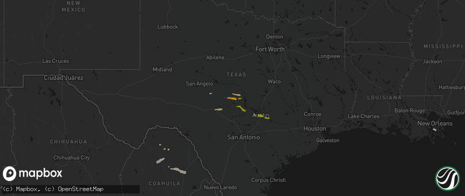
Hail Map on April 30, 2026
The weather event on April 30, 2026 includes Wind and Hail maps. 3 states and 111 cities were impacted and suffered possible damage. The total estimated number of properties impacted is 118,478.
Wind
Hail
118,478
Estimated number of impacted properties by a 1.00" hail or larger279
Estimated number of impacted properties by a 1.75" hail or larger0
Estimated number of impacted properties by a 2.50" hail or largerStates Impacted by Hail Map on April 30, 2026
Storm reports
Texas
| Date | Description |
|---|---|
| 04/30/20262:04 PM CDT | Report from mping. Quarter |
| 04/30/20261:54 PM CDT | 1 inch hail reported. |
| 04/30/202611:36 AM CDT | Picture on social media of golf ball size hail. |
| 04/30/20261:38 AM CDT | The emergency manager relayed a report of quarter size hail in belmont. |
| 04/30/202612:31 AM CDT | Report from mping: half dollar |
| 04/30/202612:28 AM CDT | Report from mping: quarter |
| 04/30/202612:28 AM CDT | Report from mping: quarter |
| 04/30/202612:26 AM CDT | Report of hail near the intersection of scarsdale blvd and beamer rd in se harris county. |
| 04/30/202612:15 AM CDT | Report of 1 inch hail near the intersection of cullen blvd and hawk rd. |
| 04/30/202612:05 AM CDT | Reported near the intersection of turtle creek dr and point clear dr. Large volume of nickel sized hail... But largest stones were over 1 inch but less than 1.5 inches. |
| 04/30/202612:00 AM CDT | Report of estimated ping pong sized hail near the intersection of austin parkway and sweetwater blvd. |
| 04/29/202611:55 PM CDT | Public reports of estimated 1 inch hail in sugar land. |
| 04/29/202611:36 PM CDT | Corrects previous hail report from asherton from 11:36 am to 11:36 pm. Picture on social media of golf ball size hail. |
| 04/29/202611:31 PM CDT | Quarter size hail in asherton. |
Cities Impacted by Hail Map on April 30, 2026
- Georgetown, SC
- McClellanville, SC
- Brady, TX
- San Saba, TX
- Hext, TX
- Cherokee, TX
- Mason, TX
- Fredonia, TX
- Pontotoc, TX
- Valley Spring, TX
- Llano, TX
- Menard, TX
- Eden, TX
- Tow, TX
- Huntsville, TX
- Art, TX
- Castell, TX
- Oakhurst, TX
- Pointblank, TX
- Round Mountain, TX
- Junction, TX
- Fredericksburg, TX
- Willow City, TX
- Johnson City, TX
- Austin, TX
- Dripping Springs, TX
- Del Valle, TX
- Cedar Creek, TX
- Bastrop, TX
- Ama, LA
- Des Allemands, LA
- Barataria, LA
- Raceland, LA
- Lafitte, LA
- Belle Chasse, LA
- Eagle Pass, TX
- East Bernard, TX
- Sealy, TX
- Carrizo Springs, TX
- Asherton, TX
- Wallis, TX
- Laredo, TX
- Catarina, TX
- Richmond, TX
- Fulshear, TX
- Rosenberg, TX
- Big Wells, TX
- Sugar Land, TX
- Quemado, TX
- Pearland, TX
- Manvel, TX
- Rosharon, TX
- Stafford, TX
- Houston, TX
- Fresno, TX
- Missouri City, TX
- Cotulla, TX
- Crystal City, TX
- Alvin, TX
- Friendswood, TX
- Webster, TX
- Seabrook, TX
- Pasadena, TX
- La Porte, TX
- Batesville, TX
- Fowlerton, TX
- Tilden, TX
- La Pryor, TX
- Marion, TX
- Seguin, TX
- McQueeney, TX
- New Braunfels, TX
- Kingsbury, TX
- Pearsall, TX
- Dilley, TX
- Leesville, TX
- Gonzales, TX
- League City, TX
- Luling, TX
- Calliham, TX
- Baytown, TX
- Harwood, TX
- Campbellton, TX
- Waelder, TX
- Flatonia, TX
- Shiner, TX
- Moulton, TX
- Karnes City, TX
- Charlotte, TX
- Hallettsville, TX
- Schulenburg, TX
- Jourdanton, TX
- Kenedy, TX
- Runge, TX
- Nordheim, TX
- Weimar, TX
- Oakland, TX
- Garwood, TX
- Columbus, TX
- Three Rivers, TX
- Yorktown, TX
- Cuero, TX
- Sheridan, TX
- Eagle Lake, TX
- Whitsett, TX
- Gillett, TX
- Katy, TX
- Christine, TX
- Pleasanton, TX
- Falls City, TX
- Hobson, TX