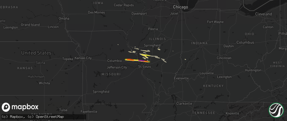
Hail Map on May 3, 2026
The weather event on May 3, 2026 includes Wind and Hail maps. 7 states and 103 cities were impacted and suffered possible damage. The total estimated number of properties impacted is 45,369.
Wind
Hail
45,369
Estimated number of impacted properties by a 1.00" hail or larger26,748
Estimated number of impacted properties by a 1.75" hail or larger0
Estimated number of impacted properties by a 2.50" hail or largerStates Impacted by Hail Map on May 3, 2026
Storm reports
Missouri
| Date | Description |
|---|---|
| 05/02/202610:08 PM CDT | A local report indicates 1.75 inch wind near Troy |
| 05/02/202610:02 PM CDT | Report from mping: quarter |
| 05/02/20269:58 PM CDT | A local report indicates 1.75 inch wind near Hawk Point |
| 05/02/20269:55 PM CDT | Report from mping: ping pong ball |
Nevada
| Date | Description |
|---|---|
| 05/03/20266:45 PM CDT | Mesonet station a04aa 30.6 n mercury |
| 05/03/20266:15 PM CDT | Mesonet station a06aa 16.4 n mercury |
| 05/03/20265:20 PM CDT | Mesonet station nv052 south verdi. |
| 05/03/20265:20 PM CDT | Mesonet station nv013 northwest reno. |
| 05/03/20264:53 PM CDT | Asos station krno reno. |
| 05/03/20264:31 PM CDT | Mesonet station nemnv 4.6 s gold hill |
| 05/03/20264:30 PM CDT | Mesonet station nv025 carson city. |
California
| Date | Description |
|---|---|
| 05/03/20265:15 PM CDT | Quincy fire department reported three downed trees associated with strong thunderstorms. Observed peak wind gusts were up to 45 mph. |
Illinois
| Date | Description |
|---|---|
| 05/02/202611:42 PM CDT | Via email... No photo. Time estimated via radar. |
| 05/02/202611:06 PM CDT | A local report indicates 1.00 inch wind near Bethalto |
| 05/02/202611:05 PM CDT | A local report indicates 1.50 inch wind near 1 NNE Bethalto |
| 05/02/202611:00 PM CDT | Email report showing 2 inch stone next to tape measure. Time estimated from radar. |
| 05/02/202610:59 PM CDT | A local report indicates 1.75 inch wind near 1 S Godfrey |
| 05/02/202610:58 PM CDT | A local report indicates 1.00 inch wind near Alton |
| 05/02/202610:58 PM CDT | Report from mping: golf ball |
| 05/02/202610:55 PM CDT | Report from mping: ping pong ball |
| 05/02/202610:55 PM CDT | Report from mping: quarter |
Wyoming
| Date | Description |
|---|---|
| 05/03/20264:46 PM CDT | Mesonet station wy60 3.4 w van tassell |
Nebraska
| Date | Description |
|---|---|
| 05/03/20265:42 PM CDT | Asos station kcdr chadron airport - cdr. |
South Dakota
| Date | Description |
|---|---|
| 05/03/20265:15 PM CDT | A local report indicates 63 MPH wind near 11 SSW Oelrichs |
Oregon
| Date | Description |
|---|---|
| 05/03/20266:45 PM CDT | *** 2 inj *** corrects previous tstm wnd dmg report from 3 ese grants pass. Large tree down on multiple mobile homes. |
| 05/03/20266:45 PM CDT | Large tree down on multiple mobile homes. |
| 05/03/20266:30 PM CDT | Large tree down across road. |
Cities Impacted by Hail Map on May 3, 2026
- Calpine, CA
- Tiller, OR
- Chester, CA
- Central Point, OR
- Williams, OR
- Grants Pass, OR
- Gold Hill, OR
- Edgemont, SD
- Harrison, NE
- Whitney, NE
- Chadron, NE
- Oelrichs, SD
- Cave Junction, OR
- Wellsville, MO
- Montgomery City, MO
- High Hill, MO
- New Florence, MO
- Bellflower, MO
- Truxton, MO
- Jonesburg, MO
- Hawk Point, MO
- Silex, MO
- Warrenton, MO
- Troy, MO
- Brownstown, IL
- Moscow Mills, MO
- Saint Elmo, IL
- Winfield, MO
- Old Monroe, MO
- Golden Eagle, IL
- Brussels, IL
- Shelbyville, MO
- Mason, IL
- Farina, IL
- O'Fallon, MO
- Portage Des Sioux, MO
- Batchtown, IL
- Grafton, IL
- Saint Charles, MO
- Taylorville, IL
- Edgewood, IL
- Assumption, IL
- West Alton, MO
- Godfrey, IL
- Dow, IL
- East Alton, IL
- Cottage Hills, IL
- Bethalto, IL
- Elsah, IL
- Alton, IL
- Moro, IL
- Worden, IL
- Edwardsville, IL
- Hamel, IL
- Wood River, IL
- Bowling Green, MO
- Frankford, MO
- Louisiana, MO
- Alhambra, IL
- Pleasant Hill, IL
- Carrollton, IL
- Nebo, IL
- Clarksville, MO
- Eldred, IL
- Rockbridge, IL
- Kane, IL
- Chesterfield, IL
- Carlinville, IL
- Medora, IL
- Stonington, IL
- Shipman, IL
- Rockport, IL
- Gillespie, IL
- Litchfield, IL
- Piasa, IL
- Hillsboro, IL
- Butler, IL
- Coffeen, IL
- Bingham, IL
- Ramsey, IL
- Fillmore, IL
- Bunker Hill, IL
- Jerseyville, IL
- Brighton, IL
- Irving, IL
- Pittsfield, IL
- Altamont, IL
- Witt, IL
- Pearl, IL
- Roodhouse, IL
- New Salem, IL
- Greenfield, IL
- Hettick, IL
- Modesto, IL
- Palmyra, IL
- Franklin, IL
- Murrayville, IL
- Charleston, IL
- Girard, IL
- Virden, IL
- Carlisle, IN
- Dugger, IN
- Dorsey, IL