Hail Map on May 7, 2026
The weather event on May 7, 2026 includes Hail and Wind maps. 6 states and 56 cities were impacted and suffered possible damage. The total estimated number of properties impacted is 3,576.
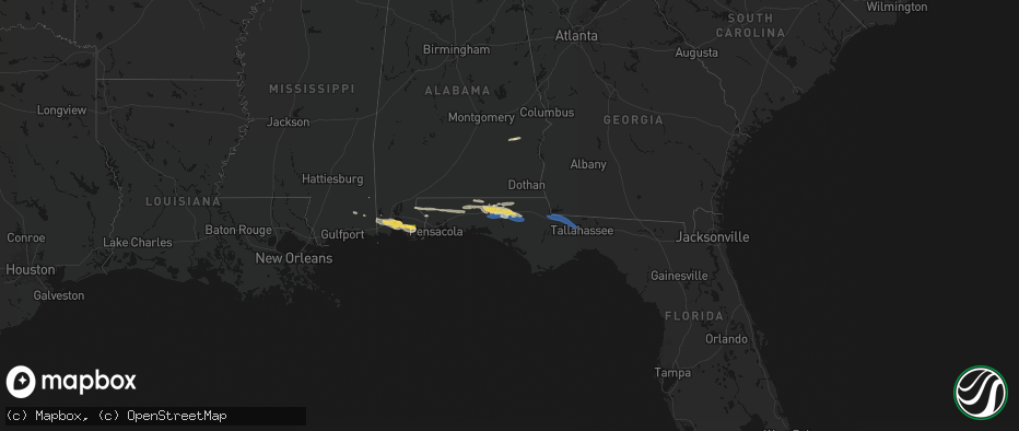
Hail
Wind
3,576
Estimated number of impacted properties by a 1.00" hail or larger0
Estimated number of impacted properties by a 1.75" hail or larger0
Estimated number of impacted properties by a 2.50" hail or largerStorm reports
Florida
| Date | Description |
|---|---|
| 05/07/20261:04 PM CDT | Report from a bank near the al/fl line of quarter size hail. |
| 05/07/202612:18 PM CDT | Tree reported down on e park ave near victory garden. |
| 05/07/202612:18 PM CDT | Electrical lines reported down on olson road and raymond diehl road. |
| 05/07/202612:18 PM CDT | Tree reported down on blair stone and e park ave. |
| 05/07/202612:12 PM CDT | Trees reported down on n meridian rd and iamonia farms rd. |
| 05/07/202612:06 PM CDT | Trees reported down on old bainbridge road near danesborogh drive and fred george road. |
| 05/07/202612:06 PM CDT | Tree reported down on n monroe st. |
| 05/07/202611:59 AM CDT | Trees down in quincy. Additional trees down reported elsewhere in the county - location being determined. |
| 05/07/202610:36 AM CDT | Trees down on powerlines on highway 79 north of vernon. |
| 05/07/202610:36 AM CDT | Numerous downed trees in vernon. One building with roof damage. |
| 05/07/202610:05 AM CDT | Numerous trees and power lines reported down around the defuniak springs area. |
| 05/07/20269:50 AM CDT | Numerous trees down between paxton and new harmony. Time estimated by radar. |
| 05/07/20269:15 AM CDT | Report of a tree down on hwy 79 n near bonifay. |
| 05/07/20269:10 AM CDT | Tree reported down on mill creek road. |
| 05/07/20269:10 AM CDT | Tree reported down on hwy 77 near graceville. |
| 05/07/20268:54 AM CDT | Several trees reported down on hwy 177. |
| 05/07/20268:36 AM CDT | Report of wind damage on jw miller road. |
Alabama
| Date | Description |
|---|---|
| 05/07/20269:55 AM CDT | A local report indicates 1.00 inch wind near 1 SW Summerdale |
| 05/07/20267:24 AM CDT | Report of powerlines down near al 85 and east neva drive in rd. |
| 05/07/20267:06 AM CDT | Report of a tree down on cr17 near rolling pine. |
Cities Impacted by Hail Map on May 7, 2026
- Brackettville, TX
- Rocksprings, TX
- McDavid, FL
- Bay Minette, AL
- Molino, FL
- Jay, FL
- Laurel Hill, FL
- Milton, FL
- Holt, FL
- Midway, AL
- Union Springs, AL
- Banks, AL
- Lucedale, MS
- Perkinston, MS
- Baker, FL
- Barksdale, TX
- Bonifay, FL
- Camp Wood, TX
- Theodore, AL
- Grand Bay, AL
- Mobile, AL
- Irvington, AL
- Crestview, FL
- Leakey, TX
- Fairhope, AL
- Daphne, AL
- Silverhill, AL
- Cantonment, FL
- Defuniak Springs, FL
- Ponce De Leon, FL
- Foley, AL
- Summerdale, AL
- Westville, FL
- Elberta, AL
- Caryville, FL
- Vernon, FL
- Chipley, FL
- Junction, TX
- Eldorado, TX
- Grand Ridge, FL
- Sneads, FL
- Quincy, FL
- Chattahoochee, FL
- Christoval, TX
- Gretna, FL
- Midway, FL
- Havana, FL
- Tallahassee, FL
- Florala, AL
- Lockhart, AL
- Samson, AL
- Kinston, AL
- Navasota, TX
- Merryville, LA
- Waller, TX
- Madisonville, TX