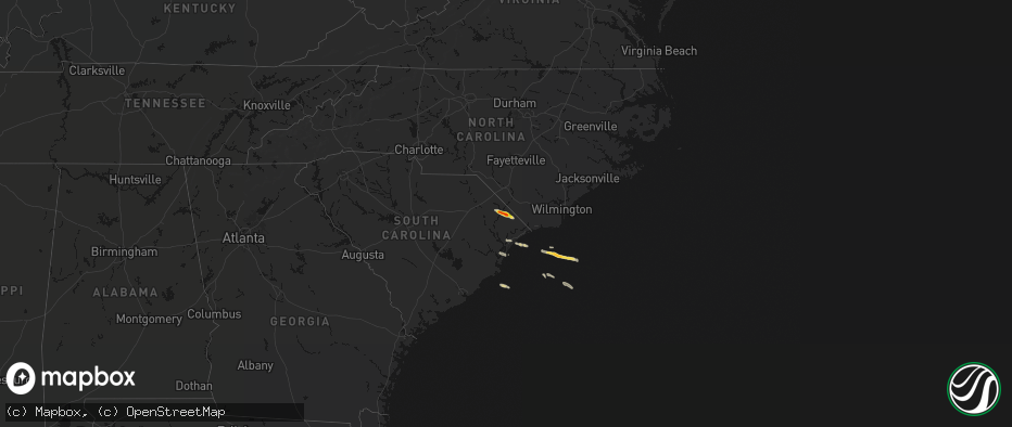
Hail Map on May 11, 2026
The weather event on May 11, 2026 includes Hail, Wind, and Tornado maps. 4 states and 15 cities were impacted and suffered possible damage. The total estimated number of properties impacted is 1,078.
Hail
Wind
Tornado
1,078
Estimated number of impacted properties by a 1.00" hail or larger327
Estimated number of impacted properties by a 1.75" hail or larger0
Estimated number of impacted properties by a 2.50" hail or largerStates Impacted by Hail Map on May 11, 2026
Storm reports
South Carolina
| Date | Description |
|---|---|
| 05/11/20261:41 PM CDT | Golf ball sized hail confirmed via photo sent in |
| 05/11/20261:30 PM CDT | Quarter size hail in cedar creek |
| 05/11/20261:15 PM CDT | Semi-trailer blown over |
| 05/11/20261:15 PM CDT | Tree fell on a home causing major damage near highway 17... Between myrtle beach and socastee. Time estimated via radar. |
| 05/11/20261:11 PM CDT | Tree down on house along watergate dr. Time estimated by radar. |
Louisiana
| Date | Description |
|---|---|
| 05/10/20268:20 PM CDT | St. John parish sheriff office reported power outages in paulina. Possible tornado. Time estimated from entergy power outage map. |
| 05/10/20268:20 PM CDT | Home with minor shingle damage on lena street in grand point. Possible tornado. |
Florida
| Date | Description |
|---|---|
| 05/10/20268:25 PM CDT | Fort pierce... St. Lucie county international airport measured a peak wind gust of 58mph/50kt from the northwest at 9:25 pm. Earlier... A gust to 39mph/34kt occurred at |
North Carolina
| Date | Description |
|---|---|
| 05/11/202612:45 PM CDT | Progress energy reports 12 outages due to damage to their equipment. Time estimated based on radar. |
| 05/11/202611:45 AM CDT | Large tree down on river rd |