Hail Map on May 21, 2026
The weather event on May 21, 2026 includes Hail and Tornado maps. 11 states and 145 cities were impacted and suffered possible damage. The total estimated number of properties impacted is 5,721.
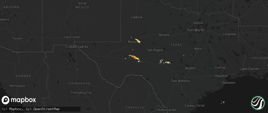
Hail
Tornado
5,721
Estimated number of impacted properties by a 1.00" hail or larger1,476
Estimated number of impacted properties by a 1.75" hail or larger550
Estimated number of impacted properties by a 2.50" hail or largerStates Impacted by Hail Map on May 21, 2026
Storm reports
Texas
| Date | Description |
|---|---|
| 05/21/20265:35 PM CDT | Half-inch to one-inch size hail. |
| 05/21/20265:08 PM CDT | Mesonet station 156 marfa 13se. |
| 05/21/20264:27 PM CDT | Video posted on facebook of golf-ball size hail on cr404 near interstate 10. |
| 05/20/20267:58 PM CDT | Mesonet station ur144 14.1 sw toyah |
Georgia
| Date | Description |
|---|---|
| 05/21/20265:15 PM CDT | Tree on house at south broad street and 6th street. |
| 05/21/20265:15 PM CDT | Tree down across roadway at 400 block of east spring street. |
Mississippi
| Date | Description |
|---|---|
| 05/21/20264:15 PM CDT | Report of trees down near wolf ridge lane in poplarville. Time estimated by radar. |
| 05/21/20263:40 AM CDT | *** 1 inj *** tree fell on a car along the natchez trace around mile marker 58. Inj person was airlifted. Est winds at this location and time appear be 40 mph or less. |
Colorado
| Date | Description |
|---|---|
| 05/21/20266:50 PM CDT | Storm chaser estimated hail size was 4.5 inches in diameter. |
| 05/21/20266:47 PM CDT | Brief tornado lasted one minute. |
| 05/21/20266:47 PM CDT | Report from mping: tea cup |
| 05/21/20266:44 PM CDT | Report from mping: baseball |
| 05/21/20266:44 PM CDT | A local report indicates 2.75 inch wind near 2 WNW Thurman |
| 05/21/20266:41 PM CDT | Tornado lasted 4 minutes. |
| 05/21/20266:35 PM CDT | Brief ground circulation. Report via nwschat. |
| 05/21/20266:34 PM CDT | Report from mping: half dollar |
| 05/21/20266:31 PM CDT | Quarter to half dollar size hail. |
| 05/21/20266:31 PM CDT | Report from mping: quarter |
| 05/21/20266:19 PM CDT | Report from mping: tennis ball |
| 05/21/20266:06 PM CDT | A local report indicates 2.50 inch wind near 5 SSE Last Chance |
| 05/21/20265:58 PM CDT | Report from mping: golf ball |
| 05/21/20265:50 PM CDT | Report from mping: quarter |
| 05/21/20265:02 PM CDT | Report from mping: ping pong ball |
| 05/21/20264:45 PM CDT | [landspout] brief landspout. |
| 05/21/20264:44 PM CDT | A local report indicates 1.00 inch wind near Deer Trail |
| 05/21/202612:28 AM CDT | Social media report of quarter size hail 2.6 miles north of kirk... Co at ~11:28 pm mdt thu may 21 |
| 05/20/20269:48 PM CDT | Mping report. |
| 05/20/20269:48 PM CDT | Report from mping: golf ball |
| 05/20/20269:23 PM CDT | Report from mping: half dollar |
| 05/20/20269:17 PM CDT | Report from mping: golf ball |
| 05/20/20269:10 PM CDT | Twitter photo and video... Message said golf ball size. Time estimated from radar. |
| 05/20/20268:55 PM CDT | A local report indicates 2.50 inch wind near 7 NNW Stratton |
| 05/20/20268:48 PM CDT | Report from mping: tennis ball |
| 05/20/20268:11 PM CDT | Reported at this location and continued for a mile north. |
| 05/20/20267:07 PM CDT | Report from mping: ping pong ball |
Kansas
| Date | Description |
|---|---|
| 05/20/202610:45 PM CDT | A local report indicates 59 MPH wind near 4 S Dighton |
| 05/20/202610:14 PM CDT | A personal weather station recorded a 58 mph wind gust. |
| 05/20/202610:13 PM CDT | A personal weather station recorded a 62 mph wind gust. |
| 05/20/20269:59 PM CDT | Personal weather station recorded a 61 mph wind gust. |
| 05/20/20269:57 PM CDT | A local report indicates 63 MPH wind near 2 E Shallow Water |
| 05/20/20268:17 PM CDT | Report from mping: quarter |
| 05/20/20267:35 PM CDT | Corrects previous non-tstm wnd gst report from coolidge. |
Nebraska
| Date | Description |
|---|---|
| 05/21/20265:59 PM CDT | Emergency manager observed a quick tornado spinup that lasted about 30 seconds. |
| 05/21/20265:51 PM CDT | Nws employee reported a tornado due west of location. |
| 05/21/20265:50 PM CDT | Corrects previous hail report from 3 e bushnell. Em reported quarter-sized hail 3 mi east of bushnell. |
North Carolina
| Date | Description |
|---|---|
| 05/21/20263:55 PM CDT | Large tree fell on powerline. Radar est. Toc 1655. Public reported 1715. |
| 05/21/20261:49 PM CDT | Multiple trees down on road. |
New Mexico
| Date | Description |
|---|---|
| 05/21/20265:51 PM CDT | A local report indicates 1.00 inch wind near 7 SSE Pep |
| 05/21/20265:15 PM CDT | Numerous large stone sizes. Time estimated from radar. |
| 05/20/20267:55 PM CDT | Report of quarter size hail by trained spotter. |
| 05/20/20267:15 PM CDT | A local report indicates 1.25 inch wind near Milnesand |
Wyoming
| Date | Description |
|---|---|
| 05/21/20265:23 PM CDT | [landspout] law enforcement reported a funnel that was producing a ground circulation for around 45 seconds and kicking up dirt/dust. |
| 05/21/20265:06 PM CDT | [landspout] cys broadcast media shared a picture of a landspout kicking up dirt/dust. |
| 05/21/20265:04 PM CDT | [landspout] report of a landspout reported by fire department. Boundary collision observed on radar at the time of the call. |
Virginia
| Date | Description |
|---|---|
| 05/21/20263:30 PM CDT | Multiple downed trees reported throughout the county after storms came through. One was reported in northern halifax county. |
| 05/21/20263:15 PM CDT | One tree down on the 16000 block of wyatts way. |
| 05/21/20263:00 PM CDT | Tree down along cottontown road. |
| 05/21/20263:00 PM CDT | Tree down near the 2800 block of camp hydaway road. |
| 05/21/20263:00 PM CDT | Tree down near goode. Radar est. Toc 1600. Called into eoc 1700. |
| 05/21/20262:55 PM CDT | One tree down near the 2600 block of thomas jefferson road. |
| 05/21/20262:55 PM CDT | Corrects previous tstm wnd dmg report from huddleston. One tree down on the 16000 block of wyatts way. |
| 05/21/20262:43 PM CDT | Several trees down along angel place rd. Radar est. Toc 1543. Called into eoc 1707. |
| 05/21/20262:27 PM CDT | Thunderstorm winds blew down one tree near the intersection of leesville road and bishop creek road. |
Cities Impacted by Hail Map on May 21, 2026
- Stanton, TX
- Morriston, FL
- Crane, TX
- Ozona, TX
- Garden City, TX
- McCamey, TX
- Springer, NM
- Evington, VA
- Lynch Station, VA
- Huddleston, VA
- Big Spring, TX
- Junction, TX
- Menard, TX
- Bell, FL
- Forest, VA
- London, TX
- Maxwell, NM
- Iraan, TX
- Fort Stockton, TX
- Branson, CO
- Gladys, VA
- Lampasas, TX
- Naples, FL
- Las Animas, CO
- Mason, TX
- Pine Ridge, SD
- Philip, SD
- Chadron, NE
- Milnesand, NM
- Oelrichs, SD
- Bonita Springs, FL
- Mitchell, NE
- Harrison, NE
- Byers, CO
- Doss, TX
- Pep, NM
- Scottsbluff, NE
- Deer Trail, CO
- Fredericksburg, TX
- Grenville, NM
- Llano, TX
- Whitney, NE
- Sterling, CO
- Rapid City, SD
- New England, ND
- Harrisburg, NE
- Marble Falls, TX
- Kenton, OK
- Pritchett, CO
- Tatum, NM
- Sonora, TX
- South Heart, ND
- Willow City, TX
- Dickinson, ND
- New Underwood, SD
- Johnson City, TX
- Burnet, TX
- Round Mountain, TX
- Dupree, SD
- Comstock, TX
- Bushnell, NE
- Enning, SD
- Iliff, CO
- Union Center, SD
- Padroni, CO
- Minatare, NE
- Lamar, CO
- Woodrow, CO
- Morton, TX
- Kimball, NE
- Dix, NE
- Campo, CO
- Buffalo, SD
- Eldorado, TX
- Boise City, OK
- Granada, CO
- Del Rio, TX
- Lindon, CO
- Genoa, CO
- Walsh, CO
- Clovis, NM
- Georgetown, TX
- Seibert, CO
- Merino, CO
- Stoneham, CO
- Bovina, TX
- New Raymer, CO
- Cope, CO
- Anton, CO
- Arriba, CO
- Rocksprings, TX
- Flagler, CO
- Manter, KS
- Vona, CO
- Wimberley, TX
- Fischer, TX
- Elida, NM
- Joes, CO
- Fort Morgan, CO
- San Marcos, TX
- Keyes, OK
- Buda, TX
- Driftwood, TX
- Dalhart, TX
- Nara Visa, NM
- Strasburg, CO
- Hazen, ND
- Snyder, CO
- Bennett, CO
- Mott, ND
- Leakey, TX
- Peetz, CO
- Hettinger, ND
- New Leipzig, ND
- Beulah, ND
- Crossroads, NM
- Rolla, KS
- Agate, CO
- Glen Ullin, ND
- Otis, CO
- Stratton, CO
- Hugoton, KS
- Stratford, TX
- Tarpley, TX
- Limon, CO
- Medina, TX
- Gruver, TX
- Hondo, TX
- D Hanis, TX
- Guymon, OK
- Channing, TX
- Hardesty, OK
- Liberal, KS
- Bethune, CO
- Hartley, TX
- Turpin, OK
- Bandera, TX
- Sunray, TX
- San Antonio, TX
- Burlington, CO
- Marathon, TX
- Dryden, TX
- Kirk, CO
- Hooker, OK
- Raymond, MS