Hail Map on September 11, 2016
The weather event on September 11, 2016 includes Hail map. 10 states and 151 cities were impacted and suffered possible damage. The total estimated number of properties impacted is 36.
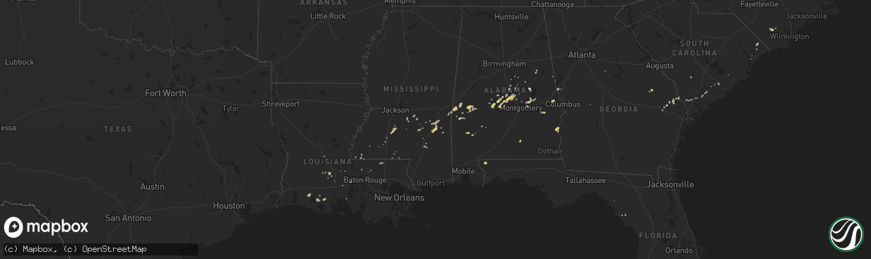
Hail
36
Estimated number of impacted properties by a 1.00" hail or larger0
Estimated number of impacted properties by a 1.75" hail or larger0
Estimated number of impacted properties by a 2.50" hail or largerStates Impacted by Hail Map on September 11, 2016
Storm reports
North Carolina
| Date | Description |
|---|---|
| 09/11/20164:00 PM CDT | Trees down and fences damaged on willeyton rd. Between gates bank rd. And parker rd. |
South Carolina
| Date | Description |
|---|---|
| 09/11/20166:08 PM CDT | Sc highway patrol reports a tree down near intersection of cohen road and calf pen bay road. |
| 09/11/20166:06 PM CDT | Tree down across power lines near intersection of grays highway and calf pen bay road. |
Massachusetts
| Date | Description |
|---|---|
| 09/11/201610:00 AM CDT | Large limb down in north end of city |
| 09/11/20169:32 AM CDT | Tree down on concord ave and tree down at concord ave and fresh pond parkway |
| 09/11/20169:30 AM CDT | Tree down on waban ave blocking road |
| 09/11/20169:30 AM CDT | Tree down on power lines |
| 09/11/20169:25 AM CDT | Trees and wires down on powder mill and sudbury roads |
| 09/11/20169:25 AM CDT | Tree down on house on rabitt road |
| 09/11/20169:20 AM CDT | Tree down on house on orchard street |
| 09/11/20169:17 AM CDT | Tree down on wachusett by pleasant street |
| 09/11/20169:15 AM CDT | Trees and wires down in the warrendale section of the city |
| 09/11/20169:15 AM CDT | Tree down on car on washington street |
| 09/11/20169:00 AM CDT | Tree down |
| 09/11/20169:00 AM CDT | Tree down on barre road |
| 09/11/20168:55 AM CDT | Trees down on route 110 near interstate 495 |
| 09/11/20168:53 AM CDT | *** 1 inj *** tree down on man... Transported by ambulance |
| 09/11/20168:45 AM CDT | Large branch down on car blocking hope street |
| 09/11/20168:45 AM CDT | Trees and wires down on jenkins road |
| 09/11/20168:40 AM CDT | Large limb down on river street |
| 09/11/20168:39 AM CDT | Wires down on chestnut street |
| 09/11/20168:36 AM CDT | Tree down across pearl brook road as well as tree and wires down route 13 brookline road and meadow road |
| 09/11/20168:35 AM CDT | Several trees down on riverbend road |
| 09/11/20168:35 AM CDT | Wires down on several streets |
| 09/11/20168:33 AM CDT | Large branches down |
| 09/11/20168:31 AM CDT | Trees and wires down on campbell street... Pleasentdale road and lincoln road |
| 09/11/20168:30 AM CDT | Trees down on multiple streets |
| 09/11/20168:30 AM CDT | Several trees down across the town |
| 09/11/20168:28 AM CDT | Trees down in the state forest |
| 09/11/20168:22 AM CDT | Multiple trees and wires down with power outages |
| 09/11/20168:22 AM CDT | A local report indicates 67 MPH wind near WEST BROOKFIELD |
| 09/11/20168:21 AM CDT | Tree down on sunrise ave and wires down on high street near peach street |
| 09/11/20168:14 AM CDT | Tree down on route 9 |
| 09/11/20168:14 AM CDT | Tree down on house on chestnut street |
| 09/11/20168:11 AM CDT | Tree down on wires on stillwater road |
| 09/11/20168:09 AM CDT | Tree down on skyline trail |
| 09/11/20168:09 AM CDT | Tree down plumtree road blocking road |
| 09/11/20168:08 AM CDT | Tree down on moore ave |
| 09/11/20168:05 AM CDT | Tree down on house on allen street |
| 09/11/20168:03 AM CDT | Multiple trees down on huckle hill raod |
| 09/11/20168:01 AM CDT | Tree down on route 20 |
| 09/11/20167:55 AM CDT | Tree down |
| 09/11/20167:53 AM CDT | Wires down chestnut street |
| 09/11/20167:48 AM CDT | Large tree on house at 33 school street |
| 09/11/20167:46 AM CDT | Tree down on route 9 by florence road |
| 09/11/20167:45 AM CDT | Tree down on wires on route 9 |
| 09/11/20167:43 AM CDT | Multiple trees down on old sunderland and taylor hills roads. |
| 09/11/20167:40 AM CDT | Tree down on wires |
| 09/11/20167:34 AM CDT | Tre down on wires |
| 09/11/20167:19 AM CDT | Tree down on wires with tree on fire. |
| 09/11/20167:05 AM CDT | Multiple trees down on property. |
New York
| Date | Description |
|---|---|
| 09/11/20167:00 AM CDT | Trees down at columbia county airport |
| 09/11/20167:00 AM CDT | 6 trees down |
Utah
| Date | Description |
|---|---|
| 09/11/20166:40 PM CDT | Dry micro-burst winds not associated with a thunderstorm knocked down several power lines on freedom blvd. |
Maine
| Date | Description |
|---|---|
| 09/11/201610:20 AM CDT | Large braches down |
| 09/11/201610:10 AM CDT | Large branches down with power outages |
| 09/11/20169:45 AM CDT | Trees down on wires |
| 09/11/20169:45 AM CDT | Multiple trees down on roads and wires |
| 09/11/20169:45 AM CDT | Trees down on roads |
| 09/11/20169:40 AM CDT | Large tree down |
| 09/11/20169:35 AM CDT | Trees and power lines down |
| 09/11/20169:30 AM CDT | Trees down |
| 09/11/20169:25 AM CDT | Trees and power lines down |
| 09/11/20169:20 AM CDT | Large braches down |
| 09/11/20169:12 AM CDT | Large oak branch down. Time estimated from radar. |
| 09/11/20169:10 AM CDT | Trees down |
| 09/11/20168:45 AM CDT | Tree down |
Mississippi
| Date | Description |
|---|---|
| 09/11/20163:45 PM CDT | Multiple trees down along king road. |
Alabama
| Date | Description |
|---|---|
| 09/11/20163:48 PM CDT | Report of 10 power poles damaged along jackson road with 2100 residents without electricity. Time estimated by radar. |
| 09/11/20163:48 PM CDT | Several dozens of trees uprooted and snapped. The largest tree snapped was 18 inches in diameter. A new home under construction was heavily damaged. A davis wind sensor |
| 09/11/20163:39 PM CDT | Tree down along clay county road 31. Time estimated by radar. |
| 09/11/20163:39 PM CDT | Power line reported down near 2700 block of oaks chapel road in ashland... Al. Time estimated by radar. |
| 09/11/20162:42 PM CDT | Power line down about 20 miles west of prattville on u.s. Highway 82. Estimated 40 to 50 mph winds. Time estimated by radar. |
Georgia
| Date | Description |
|---|---|
| 09/11/20165:25 PM CDT | Tree down on a home northeast of midville. Time estimated based on radar. |
| 09/11/20163:45 PM CDT | Large limb or small pine tree fell on a home on belair rd causing roof damage. Report from the public relayed by media. |
| 09/10/20167:00 PM CDT | Trees were blown down onto power lines and one power pole was broken |
Connecticut
| Date | Description |
|---|---|
| 09/11/20168:22 AM CDT | Tree down across north street blocking road |
| 09/11/20167:46 AM CDT | Trees and wires down. |
| 09/11/20167:34 AM CDT | Trees and wires down. |
New Hampshire
| Date | Description |
|---|---|
| 09/11/20169:31 AM CDT | Multiple trees down on pierce island. Time estimated from radar. |
| 09/11/20169:30 AM CDT | Trees and power lines down |
| 09/11/20169:10 AM CDT | Trees down on homes |
| 09/11/20169:05 AM CDT | Multiple trees and power lines down |
| 09/11/20169:00 AM CDT | Trees and power lines down |
| 09/11/20168:55 AM CDT | Multiple trees down |
| 09/11/20168:55 AM CDT | Trees and power lines down |
| 09/11/20168:50 AM CDT | Multiple trees and power lines down |
| 09/11/20168:45 AM CDT | Large branches down |
| 09/11/20168:40 AM CDT | *** 1 inj *** tree down on car. Man brought to hospital. |
| 09/11/20168:35 AM CDT | Trees and power lines down |
| 09/11/20168:32 AM CDT | Trees and power lines down |
| 09/11/20168:30 AM CDT | Trees down |
| 09/11/20168:20 AM CDT | Large branches down |
| 09/11/20168:20 AM CDT | Multiple trees down through town and power outages |
| 09/11/20167:52 AM CDT | Trees down |
| 09/11/20167:52 AM CDT | Trees and power lines down |
| 09/11/20167:50 AM CDT | Trees and power lines down |
| 09/11/20167:45 AM CDT | Trees and power lines down |
| 09/11/20167:45 AM CDT | Power lines down |
| 09/11/20167:40 AM CDT | Trees and power lines down |
| 09/11/20167:35 AM CDT | Trees down |
| 09/11/20167:30 AM CDT | Trees down |
| 09/11/20167:25 AM CDT | Trees and power lines down |
| 09/11/20167:25 AM CDT | Trees down |
| 09/11/20167:10 AM CDT | Trees downed on main street |
| 09/11/20167:04 AM CDT | Numerous trees and wires downed |
| 09/11/20167:04 AM CDT | Numerous trees and wires downed |
Cities Impacted by Hail Map on September 11, 2016
- Prattville, AL
- Ridgeland, SC
- Quitman, MS
- Meridian, MS
- Dozier, AL
- Laurel, MS
- Yemassee, SC
- Abbeville, AL
- Eufaula, AL
- Georgetown, GA
- Gallion, AL
- Demopolis, AL
- Faunsdale, AL
- Linden, AL
- Marbury, AL
- Selma, AL
- Kaplan, LA
- Woodville, MS
- Franklin, VA
- Council, NC
- Sunbury, NC
- Hobbsville, NC
- Groveton, NH
- North Stratford, NH
- Rio Rancho, NM
- Corrales, NM
- Albuquerque, NM
- Salem, AL
- Opelika, AL
- Cuba, AL
- Eclectic, AL
- Tallassee, AL
- Wetumpka, AL
- Centreville, MS
- Grove Hill, AL
- Marion Junction, AL
- Taylorsville, MS
- Collins, MS
- Verbena, AL
- Billingsley, AL
- Butler, AL
- Fort Gaines, GA
- Wesson, MS
- Courtland, VA
- McDavid, FL
- Augusta, GA
- Ward, AL
- Lisman, AL
- Clanton, AL
- Jackson, AL
- Loris, SC
- Ladson, SC
- Summerville, SC
- Millen, GA
- Midville, GA
- Sweet Water, AL
- Mamou, LA
- Opelousas, LA
- Heidelberg, MS
- Alexander City, AL
- Lagrange, GA
- Livingston, AL
- Bellamy, AL
- York, AL
- Ville Platte, LA
- Columbia, NC
- Pachuta, MS
- Hazlehurst, MS
- Bamberg, SC
- Ehrhardt, SC
- Corapeake, NC
- Gates, NC
- Deatsville, AL
- Bay Springs, MS
- Newhebron, MS
- Georgetown, MS
- Ashland, AL
- Magdalena, NM
- Stanton, AL
- Green Pond, SC
- Roanoke, AL
- Statesboro, GA
- Petal, MS
- Kentwood, LA
- Newsoms, VA
- Autaugaville, AL
- Camden, AL
- Plantersville, AL
- Newington, GA
- Moselle, MS
- Shubuta, MS
- Greenwell Springs, LA
- Jones, AL
- Union Springs, AL
- Sylvania, GA
- Pike Road, AL
- Montgomery, AL
- Osyka, MS
- Gueydan, LA
- Coy, AL
- Mendenhall, MS
- Brandon, MS
- Lineville, AL
- Sylacauga, AL
- Titus, AL
- Paulding, MS
- Breaux Bridge, LA
- West Point, GA
- Tylertown, MS
- Midway, AL
- Grosse Tete, LA
- Raleigh, MS
- Waynesboro, MS
- Bolton, NC
- Lake Waccamaw, NC
- Pennington, AL
- Bogue Chitto, MS
- Hurtsboro, AL
- Vossburg, MS
- Suffolk, VA
- Reynolds, GA
- Hattiesburg, MS
- Melville, LA
- Jackson, LA
- Slaughter, LA
- Zachary, LA
- Pulaski, MS
- Tillman, SC
- Pineland, SC
- Tuskegee, AL
- Sunset, LA
- Clarkton, NC
- Seabrook, SC
- Monticello, GA
- New Iberia, LA
- Jeanerette, LA
- Smithdale, MS
- Register, GA
- Church Point, LA
- Gatesville, NC
- Lecompte, LA
- Guyton, GA
- Cameron, LA
- Lake Arthur, LA
- Magee, MS
- Marion, AL
- Greensburg, LA
- Round O, SC
- Walterboro, SC
- Conway, SC
- Brookhaven, MS