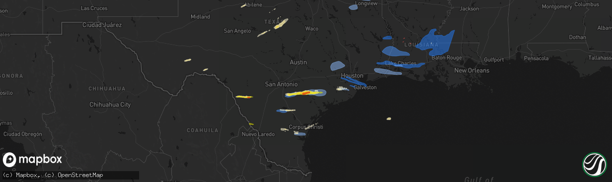
Hail Map on February 14, 2026
The weather event on February 14, 2026 includes Hail, Wind, and Tornado maps. 3 states and 315 cities were impacted and suffered possible damage. The total estimated number of properties impacted is 7,658.
Hail
Wind
Tornado
7,658
Estimated number of impacted properties by a 1.00" hail or larger1
Estimated number of impacted properties by a 1.75" hail or larger0
Estimated number of impacted properties by a 2.50" hail or largerStates Impacted by Hail Map on February 14, 2026
Storm reports
Texas
| Date | Description |
|---|---|
| 02/14/20265:59 PM CST | Power lines down and several trees with tin roof wrapped in debris reported in splendora near intersection of morgan dr at morton dr. |
| 02/14/20265:50 PM CST | Law enforcement received report of a downed power line along hwy 7 e at cr 3156. |
| 02/14/20265:19 PM CST | Report from mping: half dollar |
| 02/14/20265:15 PM CST | Law enforcement received numerous reports of wind related damage... Resulting in multiple service runs related to downed power lines across nacogdoches city and county. |
| 02/14/20265:00 PM CST | Mesonet station 124ce 116 ives creek. |
| 02/14/20265:00 PM CST | Media reported 65 mph wind gust in ives creek... Tx. |
| 02/14/20264:53 PM CST | Social media picture featuring hailstones up to penny to quarter size. Time estimated via radar. |
| 02/14/20264:50 PM CST | Quarter sized hail on smith ranch road reported by dewitt county emergency management. |
| 02/14/20264:40 PM CST | Law enforcement received reports of downed trees and power lines along fm 225 between cushing and douglass. |
| 02/14/20264:30 PM CST | Large downed tree branches greater than 6 to 9 inches in diameter. Near the intersection of cabeza road and edmund mueller northwest of nordheim. Time estimated via rad |
| 02/14/20264:14 PM CST | Report of tree down near cr 118 that the local fire department cleared off the road. |
| 02/14/20264:05 PM CST | Mesonet station tw109 three oaks. |
| 02/14/20263:53 PM CST | An mping report of power lines down was submitted north of gladewater... Tx. |
| 02/14/20263:45 PM CST | Law enforcement received a report of a downed power line at the intersection of pyeatt dr and north point pleasant rd. |
| 02/14/20263:41 PM CST | Damage to 2 houses and a boat house on lake gladewater. |
| 02/14/20263:40 PM CST | Law enforcement received a report of a downed tree along farm to market road 757. |
| 02/14/20263:40 PM CST | Law enforcement received a report of a downed tree northeast of big sandy. |
| 02/14/20263:38 PM CST | An mping report of 1-inch tree limbs broken was submitted at 3:38pm south of gilmer... Tx. |
| 02/14/20263:29 PM CST | Measured at tyler pounds field airport asos. |
| 02/14/20262:42 PM CST | Photo and video via social media with the biggest stones around or slightly bigger than a quarter. Time estimated via radar. |
| 02/13/20268:02 PM CST | Photo received of damage to deweyville united pentecostal church. Portion of the outside wooden covering was blown off. |
| 02/13/20267:59 PM CST | Kfdm mesonet. |
| 02/13/20267:48 PM CST | Report from noaa ocean service - tides and water levels obs. |
| 02/13/20267:48 PM CST | Corrects previous report from 7 wsw high island for report type. Report from noaa ocean service - tides and water levels obs. |
| 02/13/20267:38 PM CST | Measured by kfdm mesonet at utophia ranch. |
| 02/13/20267:35 PM CST | Tree limbs on home and carport. Possible tornado. |
| 02/13/20267:27 PM CST | Vfd reports tree on a home and downed powerlines. Exact location not known... Time estimated by radar. |
| 02/13/20267:25 PM CST | Mesonet station xlev levee. |
| 02/13/20267:25 PM CST | Corrects previous non-tstm wnd gst report from 4 ene texas city for proper report type. Mesonet station xlev levee. |
| 02/13/20267:22 PM CST | At kfdm mesonet lumberton middle school. |
| 02/13/20267:02 PM CST | Staircase damaged at a motel in webster at the intersection of nasa parkway and north kobayashi road. |
| 02/13/20267:00 PM CST | Mesonet station 028ce 61 rosharon. |
| 02/13/20267:00 PM CST | Mesonet station 024ce 39 chocolate springs. |
| 02/13/20266:55 PM CST | Downed tree reported at apartment complex near intersection of bay area blvd and glenwest dr. |
| 02/13/20266:51 PM CST | Fences down near blackhawk blvd at lettie ave just north of beltway 8. |
| 02/13/20266:50 PM CST | Mesonet station 141ce 143 rosharon. |
| 02/13/20266:46 PM CST | Damage reported near barbara cockrell elementary in pearland. Fences down and trampolines blown onto structures. |
| 02/13/20266:42 PM CST | Mesonet station fw9607 kingsville. |
| 02/13/20266:40 PM CST | Mesonet station 060ce 17 brazoria solar. |
| 02/13/20266:18 PM CST | Downed tree in the backyard of a residence in sugar land. |
| 02/13/20266:15 PM CST | Fence down and damage to a garage door in sugar mill |
| 02/13/20266:15 PM CST | 67 mph gust reported at sugar land regional airport. |
| 02/13/20266:12 PM CST | Asos station ksgr houston sugar la. |
Louisiana
| Date | Description |
|---|---|
| 02/14/20261:45 AM CST | Minor roof damage to a church near the intersection of talbot ave. And tiger dr. Time estimated by radar. |
| 02/14/20261:03 AM CST | A few shingles removed from a roof on arrowhead lane. |
| 02/14/20261:00 AM CST | Tree down on home in bedico trace subdivision. |
| 02/14/20261:00 AM CST | Report of a few trees down and a power pole snapped on parker road in the isabel community. Time estimated by radar. |
| 02/14/202612:55 AM CST | Tree damage and minor building damage reported on highway 25 in franklinton. |
| 02/14/202612:46 AM CST | Damage to trees and roof damage to homes near folsom. Time estimated by radar. |
| 02/14/202612:45 AM CST | Multiple trees reported down in the meadows subdivision. Possible tornado. Time estimated by radar. |
| 02/14/202612:45 AM CST | Corrects previous tstm wnd dmg report from 1 sw thibodaux. Minor roof damage to a church near the intersection of talbot ave. And tiger dr. Time estimated by radar. |
| 02/14/202612:10 AM CST | A fiberglass cooling tower at a chemical plant was damaged by straight line winds. |
| 02/14/202612:10 AM CST | Multiple power poles reported down on highway 70 near the cf industries plant and sunshine bridge. |
| 02/13/202611:06 PM CST | Power lines and pole on sugar oak road. |
| 02/13/202610:48 PM CST | Tin roofing material removed from a fishing camp. Time estimated by radar. |
| 02/13/202610:20 PM CST | Mesonet station mire. |
| 02/13/202610:13 PM CST | Report received of roof damage in port barre. One roof cave in and part of another roof was removed from a home. Time estimated by radar... Exact location not known. Po |
| 02/13/202610:10 PM CST | Tree down on i-49 service rd southbound near exit 16 near opelousas. |
| 02/13/202610:05 PM CST | Shed blown away off of ebenezer rd. |
| 02/13/20269:47 PM CST | Trees down. |
| 02/13/20269:45 PM CST | Power lines reported down in town as well as a small roof off a business in jena... Louisiana. |
| 02/13/20269:40 PM CST | A local report indicates 58 MPH wind near 2 NNE Lake Arthur |
| 02/13/20269:26 PM CST | 10 plus power poles snapped. |
| 02/13/20269:23 PM CST | Numerous trees and power lines down. Minor damage to a home. Possible tornado. |
| 02/13/20269:21 PM CST | Roof blown off home. |
| 02/13/20269:00 PM CST | Trees down near the intersection of hwy. 126 and hwy. 34 east of dodson... Louisiana. |
| 02/13/20269:00 PM CST | Metal awning torn from house... Destroyed and thrown into powerlines. |
| 02/13/20268:55 PM CST | Trees down across the roads. |
| 02/13/20268:53 PM CST | A horse trailer and a mardi gras float were overturned. Debris was blown into two employee vehicles. Two semi-permanent parked trailers were blown off of their foundati |
| 02/13/20268:53 PM CST | Asos station klch lake charles. |
| 02/13/20268:53 PM CST | Construction materials blown around airport property. Damage to jet bridge doors. Arms blown off of security gate. |
| 02/13/20268:53 PM CST | Concrete traffic signal pole displaced and turned by thunderstorm winds. |
| 02/13/20268:50 PM CST | Tree reported downed on cold branch road to tbe east of colfax. |
| 02/13/20268:50 PM CST | Large tree branch down on a home. |
| 02/13/20268:50 PM CST | Damage to front entrance doors at the walmart on nelson rd. |
| 02/13/20268:30 PM CST | Tree down just west of many... Louisiana on hwy. 6. |
| 02/13/20268:30 PM CST | Report of multiple trees and power lines down at this location associated with strong thunderstorm and possible tornado. |
| 02/13/20268:26 PM CST | Numerous reports of damage with a possible tds. |
| 02/13/20268:15 PM CST | Trees down and power outages. |
| 02/13/20268:05 PM CST | Possible tds noted on radar in association with couplet feature. |
| 02/13/20267:30 PM CST | Corrects previous tstm wnd dmg report from 1 w many. Tree down just west of many... Louisiana on hwy. 6. |
Mississippi
| Date | Description |
|---|---|
| 02/14/20261:55 AM CST | Reports of multiple trees down... Fences down... And some roof and siding damage to homes on hillsdale rd. Possible tornado. Time estimated by radar. |
| 02/14/20261:12 AM CST | Three chicken houses were damaged on gaylons drive. Tds evident from dgx radar. |
| 02/14/20261:00 AM CST | Report of multiple power lines downed across the city of prentiss. |
| 02/14/202612:27 AM CST | Tree downed on a powerline near ms hwy 184 and arm rd. Tds noted on dgx radar. |
| 02/14/202612:23 AM CST | Trees downed on oak grove rd. |
| 02/14/202612:23 AM CST | Three site built homes and two mobile homes were damaged along john peyton ln... With one of the mobile homes destroyed. Several sheds in the area were also damaged or |
| 02/14/202612:22 AM CST | Trees down blocking ethel johnson rd. |
| 02/14/202612:19 AM CST | Trees downed along foster rd. Possible tornado. |
| 02/14/202612:13 AM CST | Power lines and tree limbs downed on us 84. |
| 02/14/202612:05 AM CST | Report of tree downed on corner of house on mt. Pleasant and a tree on vehicle and detached carport on albritton lane both in bogue chitto. And trees downed in north an |
| 02/14/202612:01 AM CST | This ef1 tornado began near mount olive road and tracked northeastward across shell oil lane and ms highway 583 before lifting near highway 583 and bethel road. Along t |
| 02/14/202612:00 AM CST | Report of multiple trees downed and skirting blown off of trailer. |
| 02/13/202611:46 PM CST | This ef1 tornado began near the pike lincoln county line and tracked northeastward across southern lincoln county... Snapping and uprooted numerous trees along its path |
| 02/13/202611:40 PM CST | Trees reported down on deer creek lane. Time estimated by radar. |
| 02/13/202611:39 PM CST | Multiple trees reported down on highway 570 near the tangipahoa river and county line. Possible tornado. Time estimated by radar. |
| 02/13/202611:37 PM CST | Multiple trees reported down at the intersection of tangipahoa road and moak road. Possible tornado. Time estimated by radar. |
| 02/13/202611:37 PM CST | Mulitple trees reported down on bales road between thompson road and brown road. Possible tornado. Time estimated by radar. |
| 02/13/202611:33 PM CST | Multiple trees reported down on barron road. Possible tornado. Time estimated by radar. |
| 02/13/202611:29 PM CST | Multiple trees reported down on highway 24 between fire house rd. And east fork rd. Possible tornado. Time estimated by radar. |
| 02/13/202611:28 PM CST | Multiple trees reported down on peoria rd. Possible tornado. Time estimated by radar. |
| 02/13/202611:26 PM CST | Multiple trees reported down on patterson road. Possible tornado. Time estimated by radar. |
| 02/13/202611:25 PM CST | 4-5 downed trees reported scattered across franklin county. |
| 02/13/202611:20 PM CST | Mulitple trees reported down near mt. Zion church on highway 584. Possible tornado. Time estimated by radar. |
| 02/13/202611:02 PM CST | Roof damage to press box at high school football stadium. Possible tornado. Time estimated by radar. |
| 02/13/202611:02 PM CST | Freestanding wooden light pole at baseball stadium snapped. Metal batting cage thrown. Partial roof loss on well built shed. Possible tornado. Time estimated by radar. |
| 02/13/202611:00 PM CST | Multiple trees down in centreville. Possible tornado. Report relayed by broadcast media. |
Cities Impacted by Hail Map on February 14, 2026
- Sweetwater, TX
- Fort Stockton, TX
- Merkel, TX
- Rising Star, TX
- Dryden, TX
- Carbon, TX
- Gorman, TX
- Lohn, TX
- Melvin, TX
- Rochelle, TX
- Comstock, TX
- Brownwood, TX
- Mullin, TX
- Comanche, TX
- Zephyr, TX
- Early, TX
- Priddy, TX
- Gustine, TX
- Hamilton, TX
- Goldthwaite, TX
- Dublin, TX
- Carlton, TX
- Quemado, TX
- Eagle Pass, TX
- Crystal City, TX
- La Pryor, TX
- Batesville, TX
- Chandler, TX
- Gilmer, TX
- Ore City, TX
- Diana, TX
- Longview, TX
- Tyler, TX
- Flint, TX
- Whitehouse, TX
- Arp, TX
- Floresville, TX
- Lone Star, TX
- Avinger, TX
- Jefferson, TX
- Hallsville, TX
- Harleton, TX
- Laredo, TX
- Poth, TX
- Falls City, TX
- Pleasanton, TX
- Hobson, TX
- Karnes City, TX
- Stockdale, TX
- Gillett, TX
- Ecleto, TX
- Yorktown, TX
- Westhoff, TX
- Cuero, TX
- Yoakum, TX
- Childress, TX
- Calliham, TX
- Tilden, TX
- Three Rivers, TX
- George West, TX
- Edna, TX
- Inez, TX
- Magnolia, TX
- Pinehurst, TX
- Hallettsville, TX
- Victoria, TX
- Ganado, TX
- Louise, TX
- Beeville, TX
- Waller, TX
- Hockley, TX
- Hempstead, TX
- Chappell Hill, TX
- Bellville, TX
- Prairie View, TX
- Tomball, TX
- Washington, TX
- Brenham, TX
- Navasota, TX
- Plantersville, TX
- Montgomery, TX
- Concepcion, TX
- Boling, TX
- Pledger, TX
- Sweeny, TX
- Damon, TX
- Guy, TX
- Richmond, TX
- Sugar Land, TX
- Missouri City, TX
- Fresno, TX
- Stafford, TX
- Rosharon, TX
- Houston, TX
- Wharton, TX
- Alice, TX
- West Columbia, TX
- Kingsville, TX
- Pearland, TX
- Manvel, TX
- Alvin, TX
- Angleton, TX
- Brookeland, TX
- Pineland, TX
- Wiergate, TX
- Hemphill, TX
- Needville, TX
- Friendswood, TX
- Webster, TX
- League City, TX
- Seabrook, TX
- Liverpool, TX
- Santa Fe, TX
- Dickinson, TX
- Texas City, TX
- Kemah, TX
- Bishop, TX
- La Marque, TX
- Burkeville, TX
- Kirbyville, TX
- Corpus Christi, TX
- Bacliff, TX
- Call, TX
- Bon Wier, TX
- Port Bolivar, TX
- Lumberton, TX
- Vidor, TX
- Port Aransas, TX
- Kountze, TX
- Merryville, LA
- Newton, TX
- Buna, TX
- Orange, TX
- Beaumont, TX
- Port Arthur, TX
- Nederland, TX
- Groves, TX
- Port Neches, TX
- Leesville, LA
- Bridge City, TX
- Cameron, LA
- Deweyville, TX
- Vinton, LA
- Starks, LA
- Dequincy, LA
- Longville, LA
- Singer, LA
- Deridder, LA
- Ragley, LA
- Sulphur, LA
- Dry Creek, LA
- Kinder, LA
- Reeves, LA
- Winnie, TX
- Westlake, LA
- Lake Charles, LA
- Mittie, LA
- Oberlin, LA
- Glenmora, LA
- Creole, LA
- Bell City, LA
- Lacassine, LA
- Iowa, LA
- Ville Platte, LA
- Saint Landry, LA
- Cheneyville, LA
- Welsh, LA
- Lake Arthur, LA
- Bunkie, LA
- Jennings, LA
- Marksville, LA
- Hessmer, LA
- Alexandria, LA
- Lecompte, LA
- Morrow, LA
- Evergreen, LA
- Pineville, LA
- Cottonport, LA
- Mansura, LA
- Effie, LA
- Gueydan, LA
- Morse, LA
- Mermentau, LA
- Washington, LA
- Plaucheville, LA
- Crowley, LA
- Simmesport, LA
- Moreauville, LA
- Jonesville, LA
- Monterey, LA
- Melville, LA
- Batchelor, LA
- Lettsworth, LA
- Acme, LA
- Angola, LA
- Woodville, MS
- Saint Francisville, LA
- Vidalia, LA
- Krotz Springs, LA
- Palmetto, LA
- Port Barre, LA
- Morganza, LA
- Fordoche, LA
- Lottie, LA
- Deville, LA
- New Roads, LA
- Livonia, LA
- Maringouin, LA
- Estherwood, LA
- Rayne, LA
- Duson, LA
- Scott, LA
- Ventress, LA
- Oscar, LA
- Jarreau, LA
- Gloster, MS
- Jackson, LA
- Port Allen, LA
- Erwinville, LA
- Lakeland, LA
- Centreville, MS
- Rougon, LA
- Norwood, LA
- Glynn, LA
- Crosby, MS
- Zachary, LA
- Ethel, LA
- Slaughter, LA
- Wilson, LA
- Meadville, MS
- Liberty, MS
- Clinton, LA
- Roxie, MS
- Bude, MS
- Greensburg, LA
- Brookhaven, MS
- Sontag, MS
- Monticello, MS
- Silver Creek, MS
- Kentwood, LA
- Mccomb, MS
- Osyka, MS
- Tylertown, MS
- Magnolia, MS
- Summit, MS
- Smithdale, MS
- McCall Creek, MS
- Bogue Chitto, MS
- Amite, LA
- Mount Hermon, LA
- Prentiss, MS
- Collins, MS
- Taylorsville, MS
- Bay Springs, MS
- Winona, TX
- Ben Wheeler, TX
- Ruth, MS
- Nacogdoches, TX
- Chireno, TX
- San Augustine, TX
- Center, TX
- Thibodaux, LA
- Franklinton, LA
- Bogalusa, LA
- Angie, LA
- Folsom, LA
- Covington, LA
- Loranger, LA
- Gladewater, TX
- Galveston, TX
- Van Vleck, TX
- Saratoga, TX
- Silsbee, TX
- Nome, TX
- China, TX
- White Oak, TX
- Lafayette, LA
- Breaux Bridge, LA
- Church Point, LA
- Carencro, LA
- Belle Rose, LA
- Donaldsonville, LA
- Saint James, LA
- Convent, LA
- Paulina, LA
- Gramercy, LA
- Jayess, MS
- Foxworth, MS
- Carson, MS
- Oak Vale, MS
- Soso, MS
- Ellisville, MS
- Bassfield, MS
- Seminary, MS
- Laurel, MS
- Mount Olive, MS
- Magee, MS
- Heidelberg, MS
- Mize, MS
- Newhebron, MS
- Stringer, MS
- Paulding, MS
- Wesson, MS
- Mendenhall, MS
- Pinola, MS
- Pitkin, LA
- Sugartown, LA
- Grant, LA
- Elizabeth, LA
- Evans, LA
- Rosepine, LA
- Darrow, LA
- Geismar, LA
- Sorrento, LA
- White Castle, LA