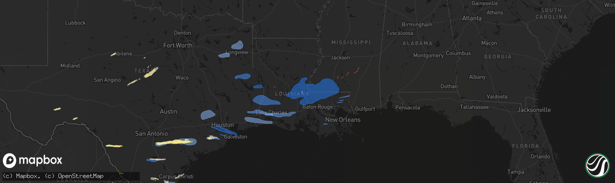
Hail Map in Louisiana on February 14, 2026
The weather event in Louisiana on February 14, 2026 includes Hail, Wind, and Tornado maps. 3 states and 315 cities were impacted and suffered possible damage. The total estimated number of properties impacted is 0.
Hail
Wind
Tornado
0
Estimated number of impacted properties by a 1.00" hail or larger0
Estimated number of impacted properties by a 1.75" hail or larger0
Estimated number of impacted properties by a 2.50" hail or largerStorm reports in Louisiana
Louisiana
| Date | Description |
|---|---|
| 02/14/20261:45 AM CST | Minor roof damage to a church near the intersection of talbot ave. And tiger dr. Time estimated by radar. |
| 02/14/20261:03 AM CST | A few shingles removed from a roof on arrowhead lane. |
| 02/14/20261:00 AM CST | Tree down on home in bedico trace subdivision. |
| 02/14/20261:00 AM CST | Report of a few trees down and a power pole snapped on parker road in the isabel community. Time estimated by radar. |
| 02/14/202612:55 AM CST | Tree damage and minor building damage reported on highway 25 in franklinton. |
| 02/14/202612:46 AM CST | Damage to trees and roof damage to homes near folsom. Time estimated by radar. |
| 02/14/202612:45 AM CST | Multiple trees reported down in the meadows subdivision. Possible tornado. Time estimated by radar. |
| 02/14/202612:45 AM CST | Corrects previous tstm wnd dmg report from 1 sw thibodaux. Minor roof damage to a church near the intersection of talbot ave. And tiger dr. Time estimated by radar. |
| 02/14/202612:10 AM CST | Multiple power poles reported down on highway 70 near the cf industries plant and sunshine bridge. |
| 02/14/202612:10 AM CST | A fiberglass cooling tower at a chemical plant was damaged by straight line winds. |
| 02/13/202611:06 PM CST | Power lines and pole on sugar oak road. |
| 02/13/202610:48 PM CST | Tin roofing material removed from a fishing camp. Time estimated by radar. |
| 02/13/202610:20 PM CST | Mesonet station mire. |
| 02/13/202610:13 PM CST | Report received of roof damage in port barre. One roof cave in and part of another roof was removed from a home. Time estimated by radar... Exact location not known. Po |
| 02/13/202610:10 PM CST | Tree down on i-49 service rd southbound near exit 16 near opelousas. |
| 02/13/202610:05 PM CST | Shed blown away off of ebenezer rd. |
| 02/13/20269:47 PM CST | Trees down. |
| 02/13/20269:45 PM CST | Power lines reported down in town as well as a small roof off a business in jena... Louisiana. |
| 02/13/20269:40 PM CST | A local report indicates 58 MPH wind near 2 NNE Lake Arthur |
| 02/13/20269:26 PM CST | 10 plus power poles snapped. |
| 02/13/20269:23 PM CST | Numerous trees and power lines down. Minor damage to a home. Possible tornado. |
| 02/13/20269:21 PM CST | Roof blown off home. |
| 02/13/20269:00 PM CST | Metal awning torn from house... Destroyed and thrown into powerlines. |
| 02/13/20269:00 PM CST | Trees down near the intersection of hwy. 126 and hwy. 34 east of dodson... Louisiana. |
| 02/13/20268:55 PM CST | Trees down across the roads. |
| 02/13/20268:53 PM CST | A horse trailer and a mardi gras float were overturned. Debris was blown into two employee vehicles. Two semi-permanent parked trailers were blown off of their foundati |
| 02/13/20268:53 PM CST | Concrete traffic signal pole displaced and turned by thunderstorm winds. |
| 02/13/20268:53 PM CST | Construction materials blown around airport property. Damage to jet bridge doors. Arms blown off of security gate. |
| 02/13/20268:53 PM CST | Asos station klch lake charles. |
| 02/13/20268:50 PM CST | Damage to front entrance doors at the walmart on nelson rd. |
| 02/13/20268:50 PM CST | Large tree branch down on a home. |
| 02/13/20268:50 PM CST | Tree reported downed on cold branch road to tbe east of colfax. |
| 02/13/20268:30 PM CST | Report of multiple trees and power lines down at this location associated with strong thunderstorm and possible tornado. |
| 02/13/20268:30 PM CST | Tree down just west of many... Louisiana on hwy. 6. |
| 02/13/20268:26 PM CST | Numerous reports of damage with a possible tds. |
| 02/13/20268:15 PM CST | Trees down and power outages. |
| 02/13/20268:05 PM CST | Possible tds noted on radar in association with couplet feature. |
| 02/13/20267:30 PM CST | Corrects previous tstm wnd dmg report from 1 w many. Tree down just west of many... Louisiana on hwy. 6. |
All States Impacted by Hail Map on February 14, 2026
Cities Impacted by Hail Map on February 14, 2026
- Sweetwater, TX
- Fort Stockton, TX
- Merkel, TX
- Rising Star, TX
- Dryden, TX
- Carbon, TX
- Gorman, TX
- Lohn, TX
- Melvin, TX
- Rochelle, TX
- Comstock, TX
- Brownwood, TX
- Mullin, TX
- Comanche, TX
- Zephyr, TX
- Early, TX
- Priddy, TX
- Gustine, TX
- Hamilton, TX
- Goldthwaite, TX
- Dublin, TX
- Carlton, TX
- Quemado, TX
- Eagle Pass, TX
- Crystal City, TX
- La Pryor, TX
- Batesville, TX
- Chandler, TX
- Gilmer, TX
- Ore City, TX
- Diana, TX
- Longview, TX
- Tyler, TX
- Flint, TX
- Whitehouse, TX
- Arp, TX
- Floresville, TX
- Lone Star, TX
- Avinger, TX
- Jefferson, TX
- Hallsville, TX
- Harleton, TX
- Laredo, TX
- Poth, TX
- Falls City, TX
- Pleasanton, TX
- Hobson, TX
- Karnes City, TX
- Stockdale, TX
- Gillett, TX
- Ecleto, TX
- Yorktown, TX
- Westhoff, TX
- Cuero, TX
- Yoakum, TX
- Childress, TX
- Calliham, TX
- Tilden, TX
- Three Rivers, TX
- George West, TX
- Edna, TX
- Inez, TX
- Magnolia, TX
- Pinehurst, TX
- Hallettsville, TX
- Victoria, TX
- Ganado, TX
- Louise, TX
- Beeville, TX
- Waller, TX
- Hockley, TX
- Hempstead, TX
- Chappell Hill, TX
- Bellville, TX
- Prairie View, TX
- Tomball, TX
- Washington, TX
- Brenham, TX
- Navasota, TX
- Plantersville, TX
- Montgomery, TX
- Concepcion, TX
- Boling, TX
- Pledger, TX
- Sweeny, TX
- Damon, TX
- Guy, TX
- Richmond, TX
- Sugar Land, TX
- Missouri City, TX
- Fresno, TX
- Stafford, TX
- Rosharon, TX
- Houston, TX
- Wharton, TX
- Alice, TX
- West Columbia, TX
- Kingsville, TX
- Pearland, TX
- Manvel, TX
- Alvin, TX
- Angleton, TX
- Brookeland, TX
- Pineland, TX
- Wiergate, TX
- Hemphill, TX
- Needville, TX
- Friendswood, TX
- Webster, TX
- League City, TX
- Seabrook, TX
- Liverpool, TX
- Santa Fe, TX
- Dickinson, TX
- Texas City, TX
- Kemah, TX
- Bishop, TX
- La Marque, TX
- Burkeville, TX
- Kirbyville, TX
- Corpus Christi, TX
- Bacliff, TX
- Call, TX
- Bon Wier, TX
- Port Bolivar, TX
- Lumberton, TX
- Vidor, TX
- Port Aransas, TX
- Kountze, TX
- Merryville, LA
- Newton, TX
- Buna, TX
- Orange, TX
- Beaumont, TX
- Port Arthur, TX
- Nederland, TX
- Groves, TX
- Port Neches, TX
- Leesville, LA
- Bridge City, TX
- Cameron, LA
- Deweyville, TX
- Vinton, LA
- Starks, LA
- Dequincy, LA
- Longville, LA
- Singer, LA
- Deridder, LA
- Ragley, LA
- Sulphur, LA
- Dry Creek, LA
- Kinder, LA
- Reeves, LA
- Winnie, TX
- Westlake, LA
- Lake Charles, LA
- Mittie, LA
- Oberlin, LA
- Glenmora, LA
- Creole, LA
- Bell City, LA
- Lacassine, LA
- Iowa, LA
- Ville Platte, LA
- Saint Landry, LA
- Cheneyville, LA
- Welsh, LA
- Lake Arthur, LA
- Bunkie, LA
- Jennings, LA
- Marksville, LA
- Hessmer, LA
- Alexandria, LA
- Lecompte, LA
- Morrow, LA
- Evergreen, LA
- Pineville, LA
- Cottonport, LA
- Mansura, LA
- Effie, LA
- Gueydan, LA
- Morse, LA
- Mermentau, LA
- Washington, LA
- Plaucheville, LA
- Crowley, LA
- Simmesport, LA
- Moreauville, LA
- Jonesville, LA
- Monterey, LA
- Melville, LA
- Batchelor, LA
- Lettsworth, LA
- Acme, LA
- Angola, LA
- Woodville, MS
- Saint Francisville, LA
- Vidalia, LA
- Krotz Springs, LA
- Palmetto, LA
- Port Barre, LA
- Morganza, LA
- Fordoche, LA
- Lottie, LA
- Deville, LA
- New Roads, LA
- Livonia, LA
- Maringouin, LA
- Estherwood, LA
- Rayne, LA
- Duson, LA
- Scott, LA
- Ventress, LA
- Oscar, LA
- Jarreau, LA
- Gloster, MS
- Jackson, LA
- Port Allen, LA
- Erwinville, LA
- Lakeland, LA
- Centreville, MS
- Rougon, LA
- Norwood, LA
- Glynn, LA
- Crosby, MS
- Zachary, LA
- Ethel, LA
- Slaughter, LA
- Wilson, LA
- Meadville, MS
- Liberty, MS
- Clinton, LA
- Roxie, MS
- Bude, MS
- Greensburg, LA
- Brookhaven, MS
- Sontag, MS
- Monticello, MS
- Silver Creek, MS
- Kentwood, LA
- Mccomb, MS
- Osyka, MS
- Tylertown, MS
- Magnolia, MS
- Summit, MS
- Smithdale, MS
- McCall Creek, MS
- Bogue Chitto, MS
- Amite, LA
- Mount Hermon, LA
- Prentiss, MS
- Collins, MS
- Taylorsville, MS
- Bay Springs, MS
- Winona, TX
- Ben Wheeler, TX
- Ruth, MS
- Nacogdoches, TX
- Chireno, TX
- San Augustine, TX
- Center, TX
- Thibodaux, LA
- Franklinton, LA
- Bogalusa, LA
- Angie, LA
- Folsom, LA
- Covington, LA
- Loranger, LA
- Gladewater, TX
- Galveston, TX
- Van Vleck, TX
- Saratoga, TX
- Silsbee, TX
- Nome, TX
- China, TX
- White Oak, TX
- Lafayette, LA
- Breaux Bridge, LA
- Church Point, LA
- Carencro, LA
- Belle Rose, LA
- Donaldsonville, LA
- Saint James, LA
- Convent, LA
- Paulina, LA
- Gramercy, LA
- Jayess, MS
- Foxworth, MS
- Carson, MS
- Oak Vale, MS
- Soso, MS
- Ellisville, MS
- Bassfield, MS
- Seminary, MS
- Laurel, MS
- Mount Olive, MS
- Magee, MS
- Heidelberg, MS
- Mize, MS
- Newhebron, MS
- Stringer, MS
- Paulding, MS
- Wesson, MS
- Mendenhall, MS
- Pinola, MS
- Pitkin, LA
- Sugartown, LA
- Grant, LA
- Elizabeth, LA
- Evans, LA
- Rosepine, LA
- Darrow, LA
- Geismar, LA
- Sorrento, LA
- White Castle, LA


