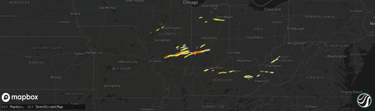
Hail Map on February 19, 2026
The weather event on February 19, 2026 includes Hail, Wind, and Tornado maps. 7 states and 245 cities were impacted and suffered possible damage. The total estimated number of properties impacted is 79,578.
Hail
Wind
Tornado
79,578
Estimated number of impacted properties by a 1.00" hail or larger6,867
Estimated number of impacted properties by a 1.75" hail or larger0
Estimated number of impacted properties by a 2.50" hail or largerStates Impacted by Hail Map on February 19, 2026
Storm reports
Illinois
| Date | Description |
|---|---|
| 02/19/20265:39 PM CST | A local report indicates 1.00 inch wind near Shobonier |
| 02/19/20265:15 PM CST | A local report indicates 1.75 inch wind near 1 NE Dudleyville |
| 02/19/20264:25 PM CST | House destroyed with occupants trapped. |
| 02/19/20264:25 PM CST | Social media report. Copious amounts of hail. |
| 02/19/20264:25 PM CST | Tornado report relayed by lawrence county emergency manager. |
| 02/19/20264:24 PM CST | Mobile home rolled over with occupants trapped. Three houses with roof off. |
| 02/19/20264:21 PM CST | Social media report. Time estimated from radar. |
| 02/19/20264:16 PM CST | A local report indicates 1.00 inch wind near Hardinville |
| 02/19/20264:16 PM CST | Delayed report. Quarter size hail reported via social media. Time estimated from radar. |
| 02/19/20264:12 PM CST | A local report indicates a tornado near 2.5 N Chauncey |
| 02/19/20264:12 PM CST | Delayed report. Time estimated by radar. Report relayed by broadcast media. |
| 02/19/20264:01 PM CST | Pea to quarter size hail for about 4 minutes and covering the ground. |
| 02/19/20263:44 PM CST | Half dollar to ping pong size hail with some golf ball size hailstones. |
| 02/19/20263:39 PM CST | Report from mping: half dollar |
| 02/19/20263:38 PM CST | Report from mping: quarter |
| 02/19/20263:38 PM CST | A local report indicates 2.00 inch wind near Dieterich |
| 02/19/20263:37 PM CST | Delayed report. Time estimated by radar. Report relayed by broadcast media. |
| 02/19/20263:16 PM CST | *** 1 inj *** corrects previous tstm wnd dmg report from 1.5 sw watson. Seven vehicle accident due to thunderstorm winds. 1 injury. |
| 02/19/20263:07 PM CST | Corrects previous tornado report from mason. Corrected location. |
| 02/19/20263:07 PM CST | A local report indicates a tornado near Mason |
| 02/19/20262:59 PM CST | Ef0... Peak wind speed 75 mph... Path length 3.0 miles. The tornado touched down just south of the clay and effingham county line... Near the edgewood rd. Curve... And |
| 02/18/20267:59 PM CST | A local report indicates 1.00 inch wind near 2 W Tremont |
| 02/18/20267:45 PM CST | A local report indicates 1.00 inch wind near Bellevue |
| 02/18/20267:25 PM CST | Half dollar size hail at sand ridge state forest. |
| 02/18/20266:28 PM CST | A local report indicates 1.00 inch wind near Ray |
| 02/18/20266:21 PM CST | A local report indicates a tornado near 4 N Bible Grove |
| 02/18/20266:15 PM CST | Ef0... 75 mph... Path length 4.1 miles. Much of the damage was concentrated at a farmstead along the clay/effingham county line east of 1800th st. Metal from the top of |
Nevada
| Date | Description |
|---|---|
| 02/18/202611:00 PM CST | The arl sord well 5b station reported a wind gust of 72 mph at 9 pm pst. |
| 02/18/202610:45 PM CST | The arl sord station 33 measured a 66 mph wind gust at 845 pm pst. |
Ohio
| Date | Description |
|---|---|
| 02/18/202611:25 PM CST | Gallia county em reported there were a few trees down in bidwell... Oh. Time estimated by radar. |
| 02/18/202611:20 PM CST | Gallia county em reported there were a few trees down on route-218 near route 7 south of gallipolis. Time estimated by radar. |
| 02/18/202611:12 PM CST | Several trees reported down in the village of williamsport. |
| 02/18/20269:17 PM CST | A single small tree uprooted. No other noteworthy damage in the area. |
Tennessee
| Date | Description |
|---|---|
| 02/19/20265:02 AM CST | Public reported a barn blown down on hunter road. Structural integrity uncertain based off of street view. Time estimated off radar. |
| 02/19/20264:42 AM CST | Knoxville mcghee tyson reported a peak wind of 60 mph associated with the convective line of showers. |
| 02/19/20264:38 AM CST | Broadcast relay of roof damage to the executive inn on chapman highway. Strips of green roof tin laying across parking lot. |
| 02/19/20264:35 AM CST | Multiple trees and powerlines down across knoxville... With at least one tree falling on a home in east knoxville. |
West Virginia
| Date | Description |
|---|---|
| 02/19/20265:55 PM CST | A local report indicates 1.75 inch wind near 3 ESE Spencer |
| 02/19/20265:23 PM CST | A local report indicates 1.25 inch wind near 5 S Kenna |
| 02/19/20264:55 PM CST | A local report indicates 1.50 inch wind near 5 SW Whitesville |
| 02/19/20264:55 PM CST | Report from mping: half dollar |
| 02/19/20264:50 PM CST | At least quarter sized hail to potentially half dollar sized hail. Social media picture. Time estimated based on radar. |
| 02/19/20262:58 PM CST | A local report indicates 1.00 inch wind near 1 SSW Fairmont |
| 02/19/20262:18 PM CST | Tree and power lines down along mud fork road. Time estimated from radar. |
| 02/19/20265:15 AM CST | Tree down blocking most of berwind mtn rd. |
| 02/19/20264:25 AM CST | Tree down dearing drive. |
| 02/19/20264:18 AM CST | 65 mph wind gust observed in sophia. Also noted some rotation in the storm. Time estimated from radar. |
| 02/19/20264:03 AM CST | Large tree down across sam black church road. |
| 02/19/20263:40 AM CST | Tree down on rt 80. Time estimated by radar. |
| 02/19/20262:30 AM CST | Tree fell into power lines and is blocking little oak st. Time estimated by radar. |
| 02/19/20261:56 AM CST | Downed tree along main hewett creek road in lake. Time estimated from radar. |
| 02/19/20261:40 AM CST | Tree down blocking rt 10. Time estimated by radar. |
| 02/19/20261:15 AM CST | Power lines down gillespie run rd. |
| 02/19/202612:33 AM CST | Tree on power lines. |
| 02/18/202611:58 PM CST | A barn roof was torn off in leroy. Time estimated from radar. |
| 02/18/202611:25 PM CST | Mason county 911 center reports a few trees down on sand hill rd just outside of point pleasant. Time estimated by radar. |
| 02/18/202611:20 PM CST | Tree down with power lines involved blocking stone lick rd. Time estimated by radar. |
| 02/18/202610:10 PM CST | Quarter size hail just outside of racine. Verified with social media photo. |
| 02/18/20266:20 PM CST | A local report indicates 1.75 inch wind near Grantsville |
Virginia
| Date | Description |
|---|---|
| 02/19/20264:40 AM CST | Tree down blocking rockhouse rd. |
| 02/19/20264:30 AM CST | Tree fell onto a vehicle also bringing down a power pole. |
Arizona
| Date | Description |
|---|---|
| 02/19/20262:33 AM CST | The tweeds point raws sensor reported a wind gust of 59 mph at 133 am mst. |
| 02/18/202610:26 PM CST | The kingman airport asos reported a 58 mph wind gust at 826 pm pst and at 901 pm pst. |
Kentucky
| Date | Description |
|---|---|
| 02/19/20263:48 PM CST | A tree was reported to have been blown down onto powerlines between mm 10 and mm 12 of ky 1812. |
| 02/19/20263:32 PM CST | Social media user shared approximately quarter-sized hailstones. Time estimated from radar. |
| 02/19/20263:28 PM CST | Social media user reports tree down on road. |
| 02/19/20263:24 PM CST | Quarter size hail was estimated to have fallen. |
| 02/19/20263:03 PM CST | A local report indicates 1.00 inch wind near 3 WSW Lexington |
| 02/19/20262:56 PM CST | Report from mping: quarter |
| 02/19/20262:54 PM CST | A local report indicates 1.00 inch wind near 3 WSW Lexington |
| 02/19/20262:54 PM CST | A local report indicates 1.00 inch wind near Lexington |
| 02/19/20262:52 PM CST | Report from mping: quarter |
| 02/19/20262:03 PM CST | A local report indicates 1.00 inch wind near Bloomfield |
| 02/19/20261:50 PM CST | A local report indicates 1.00 inch wind near 1 N Coxs Creek |
| 02/19/20261:40 PM CST | Hail a little larger than quarter size. |
| 02/19/202612:44 AM CST | Trees and powerlines were downed onto cressmont road between todds road and ky 399 closing the roadway for a period of time. The event time is radar estimated. |
Indiana
| Date | Description |
|---|---|
| 02/19/20265:47 PM CST | Time estimated from radar. Relayed via social media. |
| 02/19/20265:35 PM CST | Corrects previous hail report from 2 nw worthington. Report from mping: half dollar |
| 02/19/20265:34 PM CST | Large tree down on car. |
| 02/19/20265:30 PM CST | Delayed report. Time approximated by radar. Rough location...described as north of worthington. Along us 231... Several power poles were pushed over and left leaning to |
| 02/19/20265:30 PM CST | Delayed report. |
| 02/19/20265:25 PM CST | Approximate location. |
| 02/19/20265:23 PM CST | A local report indicates 1.25 inch wind near 2 NW Linton |
| 02/19/20265:23 PM CST | . |
| 02/19/20265:21 PM CST | A local report indicates 1.25 inch wind near Woodville Hills |
| 02/19/20264:54 PM CST | Time estimated from radar. Relayed via social media. |
| 02/19/20264:54 PM CST | Corrects previous tstm wnd dmg report from carlisle. Large tree down on car. |
| 02/19/20261:35 PM CST | Dime to quarter size hail. |
| 02/19/20261:11 PM CST | A local report indicates 1.00 inch wind near 2 E Ossian |
| 02/19/202612:45 PM CST | Hail fell for 20 minutes. |
| 02/19/202612:15 PM CST | Lots of pea to dime size hail with a few hailstones to the size of quarters. |
| 02/19/20269:53 AM CST | Asos station kgsh goshen. |
| 02/19/20268:10 AM CST | A local report indicates 1.50 inch wind near 1 E Dunkirk |
| 02/18/20269:27 PM CST | A few tree branches snapped. |
| 02/18/20268:10 PM CST | Several large tree limbs downed across town. Time estimated from radar. |
| 02/18/20267:17 PM CST | Large tree downed. Time estimated from radar. |
| 02/18/20266:52 PM CST | Report from mping: quarter |
| 02/18/20266:45 PM CST | Time estimated from radar. |
| 02/18/20266:42 PM CST | A local report indicates 1.00 inch wind near 4 SE Anderson |
| 02/18/20266:42 PM CST | . |
| 02/18/20266:21 PM CST | Corrects previous hail report from woodville hills. |
| 02/18/20266:07 PM CST | Report from mping: half dollar |
| 02/18/20266:05 PM CST | Delayed report. Time estimated from radar. Report from mping: ping pong ball |
| 02/18/20266:05 PM CST | Delayed report. Damage to monroe county humane association at 791 s fieldstone blvd... Bloomington... In. |
| 02/18/20266:01 PM CST | Bloomington monroe county airport. |
| 02/18/20266:00 PM CST | Delayed report. Deck was covered with quarter inch stones with full one inch stones mixed in about 1 to 2 per square foot. |
Cities Impacted by Hail Map on February 19, 2026
- Logansport, IN
- Royal Center, IN
- Francesville, IN
- Rensselaer, IN
- Medaryville, IN
- Winamac, IN
- Bourbon, IN
- Etna Green, IN
- Goshen, IN
- New Paris, IN
- Millersburg, IN
- Villa Ridge, MO
- Union, MO
- Pacific, MO
- Roann, IN
- North Manchester, IN
- Urbana, IN
- Servia, IN
- Lagro, IN
- Huntington, IN
- Andrews, IN
- Markle, IN
- Roanoke, IN
- Cannelton, IN
- Battletown, KY
- Leavenworth, IN
- Uniondale, IN
- Ossian, IN
- Derby, IN
- Leopold, IN
- Tell City, IN
- Payneville, KY
- Corydon, IN
- Lanesville, IN
- Coxs Creek, KY
- Taylorsville, KY
- Bloomfield, KY
- Fairfield, KY
- Laconia, IN
- Elizabeth, IN
- Chaplin, KY
- Lawrenceburg, KY
- Mount Eden, KY
- Spencer, WV
- Gandeeville, WV
- Walton, WV
- Shepherdsville, KY
- Looneyville, WV
- Willisburg, KY
- Versailles, KY
- Lexington, KY
- Nicholasville, KY
- Edgewood, IL
- Mason, IL
- Watson, IL
- Stewardson, IL
- Strasburg, IL
- Windsor, IL
- Campton, KY
- Rogers, KY
- Slade, KY
- Beattyville, KY
- Farina, IL
- Winchester, KY
- Louisa, KY
- Fort Gay, WV
- Genoa, WV
- Dunlow, WV
- Dieterich, IL
- Effingham, IL
- Gays, IL
- Mattoon, IL
- Zoe, KY
- Pine Ridge, KY
- Neoga, IL
- Wheeler, IL
- Auxier, KY
- Prestonsburg, KY
- East Point, KY
- Hazel Green, KY
- Vancleve, KY
- Jackson, KY
- Debord, KY
- Van Lear, KY
- Harts, WV
- Toledo, IL
- Jewett, IL
- Salyersville, KY
- Hagerhill, KY
- Meally, KY
- Boons Camp, KY
- Tomahawk, KY
- Newton, IL
- Montrose, IL
- Hidalgo, IL
- Bays, KY
- Rousseau, KY
- Olney, IL
- Claremont, IL
- Greenup, IL
- Dundas, IL
- Salvisa, KY
- Willow Hill, IL
- Oblong, IL
- Sumner, IL
- Robinson, IL
- Casey, IL
- Chapmanville, WV
- Yale, IL
- Ashmore, IL
- Charleston, IL
- Westfield, IL
- Flat Rock, IL
- Martinsville, IL
- Annapolis, IL
- Kansas, IL
- West York, IL
- Palestine, IL
- Hutsonville, IL
- Merom, IN
- Sullivan, IN
- Bob White, WV
- Jeffrey, WV
- Clothier, WV
- Hewett, WV
- Bim, WV
- Yolyn, WV
- Lake, WV
- Van, WV
- Marshall, IL
- Spencer, IN
- Poland, IN
- Quincy, IN
- Cloverdale, IN
- Gosport, IN
- Madison, WV
- Gordon, WV
- Twilight, WV
- Carlisle, IN
- West Union, IL
- Martinsville, IN
- Dugger, IN
- Jasonville, IN
- Linton, IN
- Greenville, IL
- Pocahontas, IL
- Paragon, IN
- Keyesport, IL
- Monrovia, IN
- Stilesville, IN
- Poca, WV
- Charleston, WV
- Elkview, WV
- Kenna, WV
- Vandalia, IL
- Smithboro, IL
- Mulberry Grove, IL
- Worthington, IN
- Switz City, IN
- Cory, IN
- Advent, WV
- Clay City, IN
- Centerpoint, IN
- Shobonier, IL
- Coal City, IN
- Bloomfield, IN
- Freedom, IN
- Solsberry, IN
- Bloomington, IN
- Brownstown, IL
- Saint Peter, IL
- Saint Elmo, IL
- Louisville, IL
- Arnoldsburg, WV
- Astoria, IL
- Rushville, IL
- Mount Zion, WV
- Grantsville, WV
- Nashville, IN
- Unionville, IN
- Coxs Mills, WV
- Big Springs, WV
- Morgantown, IN
- Nineveh, IN
- Havana, IL
- Topeka, IL
- Lewistown, IL
- Manito, IL
- Sigel, IL
- Green Valley, IL
- Pekin, IL
- Lerna, IL
- Trilla, IL
- South Pekin, IL
- Tremont, IL
- Peoria, IL
- Mapleton, IL
- Xenia, OH
- Creston, WV
- Palestine, WV
- Reedy, WV
- Sylvester, WV
- Seth, WV
- Greenfield, IN
- Columbus, IN
- Hope, IN
- Lyons, IN
- Sandborn, IN
- Canton, IL
- Bowling Green, IN
- Donnellson, IL
- Glasford, IL
- Newberry, IN
- Danville, WV
- Browning, IL
- Ipava, IL
- Highland, IL
- New Palestine, IN
- Heltonville, IN
- Norman, IN
- Glenville, WV
- New Milton, WV
- Troy, WV
- Millstone, WV
- Elizabeth, WV
- Big Bend, WV
- Le Roy, WV
- Gay, WV
- Munday, WV
- Strawberry Plains, TN
- Powell, TN
- New Market, TN
- Knoxville, TN
- Daniels, WV
- Beaver, WV
- Slab Fork, WV
- Coal City, WV
- Crab Orchard, WV
- Lester, WV
- Glen White, WV
- Sophia, WV
- Midway, WV
- Shady Spring, WV
- Ripley, WV
- Sandyville, WV