Hail Map in Bloomington, IN on February 19, 2026
The weather event in Bloomington, IN on February 19, 2026 includes Hail, Wind, and Tornado maps. 7 states and 245 cities were impacted and suffered possible damage. The total estimated number of properties impacted is 19,764.
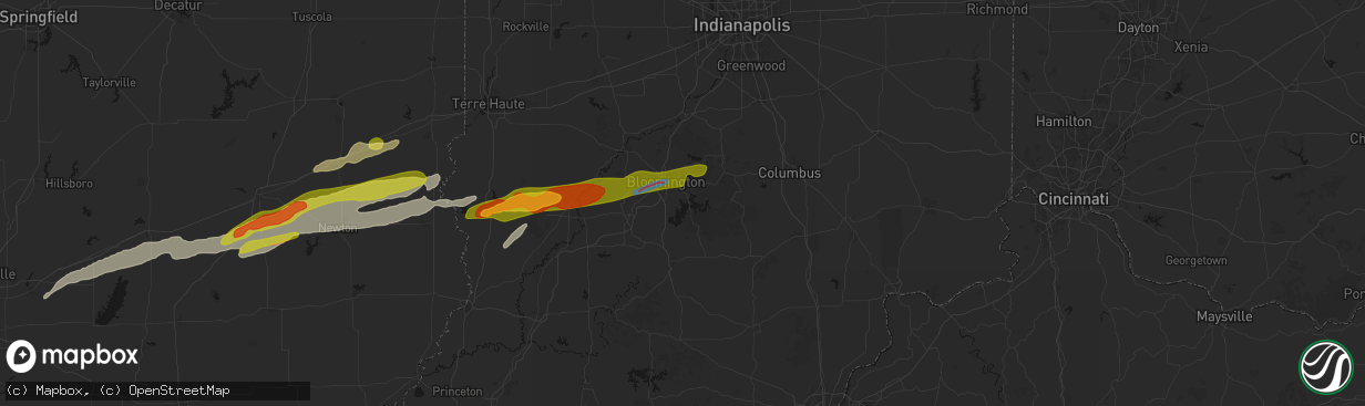
Hail
Wind
Tornado
19,764
Estimated number of impacted properties by a 1.00" hail or larger0
Estimated number of impacted properties by a 1.75" hail or larger0
Estimated number of impacted properties by a 2.50" hail or largerStorm reports in Bloomington, IN
Bloomington, IN
| Date | Description |
|---|---|
| 02/19/20265:21 PM CST | A local report indicates 1.25 inch wind near Woodville Hills |
| 02/18/20266:21 PM CST | Corrects previous hail report from woodville hills. |
| 02/18/20266:05 PM CST | Delayed report. Time estimated from radar. Report from mping: ping pong ball |
| 02/18/20266:05 PM CST | Delayed report. Damage to monroe county humane association at 791 s fieldstone blvd... Bloomington... In. |
| 02/18/20266:01 PM CST | Bloomington monroe county airport. |
| 02/18/20266:00 PM CST | Delayed report. Deck was covered with quarter inch stones with full one inch stones mixed in about 1 to 2 per square foot. |
All States Impacted by Hail Map on February 19, 2026
All Cities Impacted by Hail Map on February 19, 2026
- Logansport, IN
- Royal Center, IN
- Francesville, IN
- Rensselaer, IN
- Medaryville, IN
- Winamac, IN
- Bourbon, IN
- Etna Green, IN
- Goshen, IN
- New Paris, IN
- Millersburg, IN
- Villa Ridge, MO
- Union, MO
- Pacific, MO
- Roann, IN
- North Manchester, IN
- Urbana, IN
- Servia, IN
- Lagro, IN
- Huntington, IN
- Andrews, IN
- Markle, IN
- Roanoke, IN
- Cannelton, IN
- Battletown, KY
- Leavenworth, IN
- Uniondale, IN
- Ossian, IN
- Derby, IN
- Leopold, IN
- Tell City, IN
- Payneville, KY
- Corydon, IN
- Lanesville, IN
- Coxs Creek, KY
- Taylorsville, KY
- Bloomfield, KY
- Fairfield, KY
- Laconia, IN
- Elizabeth, IN
- Chaplin, KY
- Lawrenceburg, KY
- Mount Eden, KY
- Spencer, WV
- Gandeeville, WV
- Walton, WV
- Shepherdsville, KY
- Looneyville, WV
- Willisburg, KY
- Versailles, KY
- Lexington, KY
- Nicholasville, KY
- Edgewood, IL
- Mason, IL
- Watson, IL
- Stewardson, IL
- Strasburg, IL
- Windsor, IL
- Campton, KY
- Rogers, KY
- Slade, KY
- Beattyville, KY
- Farina, IL
- Winchester, KY
- Louisa, KY
- Fort Gay, WV
- Genoa, WV
- Dunlow, WV
- Dieterich, IL
- Effingham, IL
- Gays, IL
- Mattoon, IL
- Zoe, KY
- Pine Ridge, KY
- Neoga, IL
- Wheeler, IL
- Auxier, KY
- Prestonsburg, KY
- East Point, KY
- Hazel Green, KY
- Vancleve, KY
- Jackson, KY
- Debord, KY
- Van Lear, KY
- Harts, WV
- Toledo, IL
- Jewett, IL
- Salyersville, KY
- Hagerhill, KY
- Meally, KY
- Boons Camp, KY
- Tomahawk, KY
- Newton, IL
- Montrose, IL
- Hidalgo, IL
- Bays, KY
- Rousseau, KY
- Olney, IL
- Claremont, IL
- Greenup, IL
- Dundas, IL
- Salvisa, KY
- Willow Hill, IL
- Oblong, IL
- Sumner, IL
- Robinson, IL
- Casey, IL
- Chapmanville, WV
- Yale, IL
- Ashmore, IL
- Charleston, IL
- Westfield, IL
- Flat Rock, IL
- Martinsville, IL
- Annapolis, IL
- Kansas, IL
- West York, IL
- Palestine, IL
- Hutsonville, IL
- Merom, IN
- Sullivan, IN
- Bob White, WV
- Jeffrey, WV
- Clothier, WV
- Hewett, WV
- Bim, WV
- Yolyn, WV
- Lake, WV
- Van, WV
- Marshall, IL
- Spencer, IN
- Poland, IN
- Quincy, IN
- Cloverdale, IN
- Gosport, IN
- Madison, WV
- Gordon, WV
- Twilight, WV
- Carlisle, IN
- West Union, IL
- Martinsville, IN
- Dugger, IN
- Jasonville, IN
- Linton, IN
- Greenville, IL
- Pocahontas, IL
- Paragon, IN
- Keyesport, IL
- Monrovia, IN
- Stilesville, IN
- Poca, WV
- Charleston, WV
- Elkview, WV
- Kenna, WV
- Vandalia, IL
- Smithboro, IL
- Mulberry Grove, IL
- Worthington, IN
- Switz City, IN
- Cory, IN
- Advent, WV
- Clay City, IN
- Centerpoint, IN
- Shobonier, IL
- Coal City, IN
- Bloomfield, IN
- Freedom, IN
- Solsberry, IN
- Bloomington, IN
- Brownstown, IL
- Saint Peter, IL
- Saint Elmo, IL
- Louisville, IL
- Arnoldsburg, WV
- Astoria, IL
- Rushville, IL
- Mount Zion, WV
- Grantsville, WV
- Nashville, IN
- Unionville, IN
- Coxs Mills, WV
- Big Springs, WV
- Morgantown, IN
- Nineveh, IN
- Havana, IL
- Topeka, IL
- Lewistown, IL
- Manito, IL
- Sigel, IL
- Green Valley, IL
- Pekin, IL
- Lerna, IL
- Trilla, IL
- South Pekin, IL
- Tremont, IL
- Peoria, IL
- Mapleton, IL
- Xenia, OH
- Creston, WV
- Palestine, WV
- Reedy, WV
- Sylvester, WV
- Seth, WV
- Greenfield, IN
- Columbus, IN
- Hope, IN
- Lyons, IN
- Sandborn, IN
- Canton, IL
- Bowling Green, IN
- Donnellson, IL
- Glasford, IL
- Newberry, IN
- Danville, WV
- Browning, IL
- Ipava, IL
- Highland, IL
- New Palestine, IN
- Heltonville, IN
- Norman, IN
- Glenville, WV
- New Milton, WV
- Troy, WV
- Millstone, WV
- Elizabeth, WV
- Big Bend, WV
- Le Roy, WV
- Gay, WV
- Munday, WV
- Strawberry Plains, TN
- Powell, TN
- New Market, TN
- Knoxville, TN
- Daniels, WV
- Beaver, WV
- Slab Fork, WV
- Coal City, WV
- Crab Orchard, WV
- Lester, WV
- Glen White, WV
- Sophia, WV
- Midway, WV
- Shady Spring, WV
- Ripley, WV
- Sandyville, WV


