Hail Map in Texas on March 4, 2020
The weather event in Texas on March 4, 2020 includes Hail and Wind maps. 6 states and 100 cities were impacted and suffered possible damage. The total estimated number of properties impacted is 13,116.
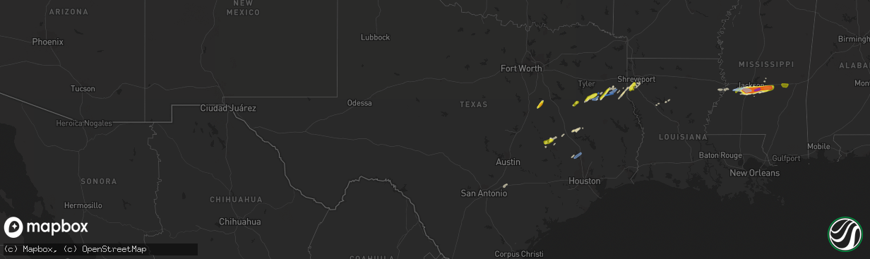
Hail
Wind
13,116
Estimated number of impacted properties by a 1.00" hail or larger54
Estimated number of impacted properties by a 1.75" hail or larger0
Estimated number of impacted properties by a 2.50" hail or largerStorm reports in Texas
Texas
| Date | Description |
|---|---|
| 03/04/20209:14 AM CST | Measured with a hand held anemometer. |
| 03/04/20209:09 AM CST | A local report indicates 1.00 inch wind near 6 NNW UR089 |
| 03/04/20208:35 AM CST | Projects for a theme park were destroyed at a property in the gause area. An 88 ft and 32 ft prop were destroyed. Silos were also moved on the property. |
| 03/04/20207:30 AM CST | Trees down on sh 42 @ cr 468 in sw rusk. |
| 03/04/20207:30 AM CST | Sheriff office reports over 25 trees down across central and south rusk county. |
| 03/04/20207:24 AM CST | Cherokee sheriff office reports trees down all over the northern part of the county. |
| 03/04/20207:10 AM CST | Tree or large limb on home east of lake striker in sw county near new salem... No injuries reported at this time. |
| 03/04/20207:07 AM CST | Multiple trees down. Roof removed from a pier at lake striker resort. Pier was destroyed. |
| 03/04/20207:05 AM CST | Trees reported down and roof damage to home roof near fm 2274 and fm 235 reported from reklaw vfd. |
| 03/04/20207:05 AM CST | Small radio tower blown down and scattered tree damage east of lake striker and along farm road 839. |
| 03/04/20206:57 AM CST | Trees were downed on fm 840 a couple of miles from henderson which forced the closure of the road. |
| 03/04/20206:52 AM CST | One inch hail reported at exxon gas station on hwy 69 southeast of jacksonville. |
| 03/04/20206:50 AM CST | One inch hail reported along hwy 259 between mount enterprise and henderson... Texas. |
| 03/04/20206:45 AM CST | Quarter size hail fell at the intersection of highway 69 and 79 in jacksonville. Report from facebook. |
| 03/04/20206:24 AM CST | At 1222 AM CST, a severe thunderstorm was located 8 miles northwest of Loma Alta, moving northeast at 35 mph. HAZARD...60 mph wind gusts and quarter size hail. SOURCE...Radar indicated. IMPACT...Hail damage to vehicles is expected. Expect wind damage to roofs, siding, and trees. Locations impacted include... Loma Alta, Vinegarone, Us-277 Near The Sutton- Edwards County Line and Devils River State Nat Area Del Norte. |
| 03/04/20206:01 AM CST | At 1201 PM CST, a severe thunderstorm was located over Willis, moving northeast at 45 mph. HAZARD...60 mph wind gusts and quarter size hail. SOURCE...Radar indicated. IMPACT...Hail damage to vehicles is expected. Expect wind damage to roofs, siding, and trees. Locations impacted include... Conroe, Willis, Panorama Village, Cut And Shoot, New Waverly, Coldspring, Point Blank, Evergreen and Oakhurst. |
| 03/04/20205:38 AM CST | At 1138 AM CST, a severe thunderstorm was located near Montgomery, or 10 miles north of Pinehurst, moving northeast at 40 mph. HAZARD...60 mph wind gusts and penny size hail. SOURCE...Radar indicated. IMPACT...Expect damage to roofs, siding, and trees. Locations impacted include... Montgomery, Plantersville, Dobbin and Dacus. |
| 03/04/20205:10 AM CST | At 1110 AM CST, a severe thunderstorm was located near Apple Springs, moving east at 45 mph. HAZARD...60 mph wind gusts and penny size hail. SOURCE...Radar indicated. IMPACT...Expect damage to roofs, siding, and trees. Locations impacted include... Apple Springs and Centralia. |
| 03/04/20204:23 AM CST | At 1023 AM CST, a severe thunderstorm was located near Lovelady, or 8 miles southeast of Austonio, moving east at 50 mph. HAZARD...60 mph wind gusts and quarter size hail. SOURCE...Radar indicated. IMPACT...Hail damage to vehicles is expected. Expect wind damage to roofs, siding, and trees. Locations impacted include... Groveton, Lovelady and Pennington. |
| 03/04/20203:13 AM CST | At 912 AM CST, a severe thunderstorm was located near Wixon Valley, or 11 miles north of Bryan, moving east at 25 mph. HAZARD...Two inch hail. SOURCE...Weather spotters reported quarter sized hail 10 miles north of Bryan. IMPACT...People and animals outdoors will be injured. Expect damage to roofs, siding, windows, and vehicles. Locations impacted include... Kurten and Wixon Valley. |
| 03/04/20202:53 AM CST | At 851 AM CST, a severe thunderstorm was located 8 miles southeast of Hearne, moving east at 50 mph. HAZARD...60 mph wind gusts and quarter size hail. SOURCE...Radar indicated. IMPACT...Hail damage to vehicles is expected. Expect wind damage to roofs, siding, and trees. Locations impacted include... Northwestern Bryan, Kurten and Wixon Valley. |
| 03/04/20202:41 AM CST | At 840 AM CST, a severe thunderstorm was located 8 miles south of Hearne, moving east at 35 mph. HAZARD...60 mph wind gusts and nickel size hail. SOURCE...Radar indicated. IMPACT...Expect damage to roofs, siding, and trees. Locations impacted include... Hearne, Wheelock, and Benchley |
| 03/04/20202:09 AM CST | At 809 AM CST, a severe thunderstorm was located near Bremond, or 11 miles southeast of Marlin, moving east at 40 mph. HAZARD...60 mph wind gusts and penny size hail. SOURCE...Radar indicated. IMPACT...Expect damage to roofs, siding, and trees. Locations impacted include... Marlin, Bremond, Thornton and Kosse. |
| 03/04/20201:52 AM CST | At 751 AM CST, a severe thunderstorm was located near Carthage, moving east at 45 mph. HAZARD...70 mph wind gusts and half dollar size hail. SOURCE...Radar indicated. IMPACT...Hail damage to vehicles is expected. Expect considerable tree damage. Wind damage is also likely to mobile homes, roofs, and outbuildings. Locations impacted include... Shreveport, Carthage, Greenwood, Blanchard, Waskom, Stonewall, Tatum, Beckville, Deberry, Elysian Fields, Easton, Scottsville, Gary City, Keachi, Longstreet, Keat Chie, Front, Spring Ridge, Cross Lake and Kingston. |
| 03/04/20201:47 AM CST | At 747 AM CST, a severe thunderstorm was located over Thorndale, or 9 miles west of Rockdale, moving east at 40 mph. HAZARD...60 mph wind gusts and penny size hail. SOURCE...Radar indicated. IMPACT...Expect damage to roofs, siding, and trees. Locations impacted include... Rockdale, Cameron, Thorndale and Milano. |
| 03/04/20201:26 AM CST | At 726 AM CST, a severe thunderstorm was located 11 miles north of Joaquin, or 15 miles east of Carthage, moving northeast at 45 mph. HAZARD...60 mph wind gusts and quarter size hail. SOURCE...Radar indicated. IMPACT...Hail damage to vehicles is expected. Expect wind damage to roofs, siding, and trees. Locations impacted include... Shreveport, Greenwood, Blanchard, Stonewall, Keachi, Longstreet, Gloster, Keat Chie, Frierson, Caspiana, Front, Spring Ridge, Cross Lake, Kingston, Midyett, Kickapoo, Keithville, Deadwood, Robson and Forbing. |
| 03/04/20201:24 AM CST | At 724 AM CST, a severe thunderstorm was located 7 miles southwest of Reese, or 12 miles west of Jacksonville, moving northeast at 45 mph. HAZARD...60 mph wind gusts and quarter size hail. SOURCE...Radar indicated. IMPACT...Hail damage to vehicles is expected. Expect wind damage to roofs, siding, and trees. Locations impacted include... Jacksonville, Whitehouse, Bullard, Troup, Arp, Mount Selman, Ponta, Mixon, Reese, New Salem, Maydelle, New Summerfield, New Chapel Hill, Gallatin, Reklaw, Cuney, Concord and Glenfawn. |
| 03/04/20201:21 AM CST | At 720 AM CST, a severe thunderstorm was located near Henderson, moving northeast at 45 mph. HAZARD...70 mph wind gusts and half dollar size hail. SOURCE...Radar indicated. IMPACT...Hail damage to vehicles is expected. Expect considerable tree damage. Wind damage is also likely to mobile homes, roofs, and outbuildings. Locations impacted include... Henderson, Carthage, Tatum, New London, Beckville, Joinerville, Pinehill, Turnertown, Minden, Easton, Gary City, Chapman, Monroe, Darco, Fairplay, Stewart, Brachfield, Chalk Hill, Dotson and Church Hill. |
| 03/04/202012:48 AM CST | At 648 AM CST, a severe thunderstorm was located near Minden, or 8 miles southeast of Henderson, moving northeast at 55 mph. HAZARD...60 mph wind gusts and quarter size hail. SOURCE...Radar indicated. IMPACT...Hail damage to vehicles is expected. Expect wind damage to roofs, siding, and trees. Locations impacted include... Henderson, Carthage, Tatum, Beckville, Pinehill, Minden, Easton, Chapman, Darco, Fairplay, Stewart, Brachfield and Church Hill. |
| 03/04/202012:44 AM CST | At 644 AM CST, a severe thunderstorm was located over Jacksonville, moving northeast at 35 mph. HAZARD...60 mph wind gusts and quarter size hail. SOURCE...Radar indicated. IMPACT...Hail damage to vehicles is expected. Expect wind damage to roofs, siding, and trees. Locations impacted include... Jacksonville, Troup, Arp, Mixon, Ponta, New Summerfield, Gallatin and Concord. |
| 03/04/202012:37 AM CST | At 637 AM CST, a severe thunderstorm was located near Coolidge, or 16 miles northwest of Mexia, moving northeast at 30 mph. HAZARD...Quarter size hail. SOURCE...Radar indicated. IMPACT...Damage to vehicles is possible. Locations impacted include... Corsicana, Dawson, Angus, Retreat, Oak Valley, Mildred and Mustang.This includes Interstate 45 between mile markers 224 and 231. |
| 03/03/202011:29 PM CST | At 528 AM CST, severe thunderstorms were located along a line extending from Rocky Creek to near Kendalia to Fair Oaks Ranch, moving east at 40 mph. HAZARD...60 mph wind gusts and penny size hail. SOURCE...Radar indicated. IMPACT...Expect damage to roofs, siding, and trees. Locations impacted include... Boerne, Dripping Springs, Blanco, Round Mountain, Canyon Lake Dam, Canyon Lake, Fair Oaks Ranch, Bulverde, Johnson City, Walnut Grove, Guadalupe River State Park, Kendalia, Smithson Valley, Rocky Creek, Kreutzberg, Spring Branch, Hye, Cypress Mill, Henly and Payton. |
| 03/03/202011:12 PM CST | At 512 AM CST, a severe thunderstorm was located near Rosevine, or 25 miles north of Ebenezer, moving northeast at 40 mph. HAZARD...60 mph wind gusts and quarter size hail. SOURCE...Radar indicated. IMPACT...Hail damage to vehicles is expected. Expect wind damage to roofs, siding, and trees. Locations impacted include... Milam, San Augustine, Zwolle, Converse, Rosevine, Patroon, Macune, Oak Grove, Huxley, Noble, Sexton, Bronson, Toledo Bend Reservoir North and Chinaquapin. |
| 03/03/202010:43 PM CST | At 442 AM CST, severe thunderstorms were located along a line extending from near Tivydale to near Cypress Creek to near Hill Country State Natural Area to near D'Hanis, moving east at 35 mph. HAZARD...60 mph wind gusts and quarter size hail. SOURCE...Radar indicated. IMPACT...Hail damage to vehicles is expected. Expect wind damage to roofs, siding, and trees. Locations impacted include... Kerrville, Boerne, Fredericksburg, Hondo, Castroville, Comfort, Bandera, Helotes, Fair Oaks Ranch, Cross Mountain, Stonewall, D'Hanis, Bandera Falls, Dunlay, Mico, Rocky Hill, Kreutzberg, Blumenthal, Waring and Albert. |
| 03/03/202010:34 PM CST | At 434 AM CST, a severe thunderstorm was located near Huntington, or 11 miles east of Lufkin, moving northeast at 55 mph. HAZARD...60 mph wind gusts and quarter size hail. SOURCE...Radar indicated. IMPACT...Hail damage to vehicles is expected. Expect wind damage to roofs, siding, and trees. Locations impacted include... Center, Huntington, San Augustine, Melrose, Woden, Patroon, Etoile, Shelbyville, Martinsville, Bland Lake, Neuville, Chireno, Hurstown, Denning, Jericho, Calgary, Stockman, Arcadia and Jordans Store. |
| 03/03/20209:56 PM CST | At 355 AM CST, severe thunderstorms were located along a line extending from 16 miles south of Segovia to near Kerr Wildlife Management Area to Vanderpool to 6 miles northwest of Knippa, moving east at 40 mph. HAZARD...60 mph wind gusts and penny size hail. SOURCE...Radar indicated. IMPACT...Expect damage to roofs, siding, and trees. Locations impacted include... Medina, Kerrville, Hondo, Bandera, Vanderpool, Tarpley, Ingram, Sabinal, Hunt, Knippa, Camp Verde, D'Hanis, Concan, Kerrville-Schreiner Park, Waltonia, Kerr Wildlife Management Area, Harper, Cypress Creek, Mountain Home and Center Point. |
| 03/03/20209:13 PM CST | At 312 AM CST, severe thunderstorms were located along a line extending from 13 miles east of Rocksprings to 6 miles southeast of Vance to near Cline to near Dabney, moving east at 40 mph. HAZARD...60 mph wind gusts and penny size hail. SOURCE...Radar indicated. IMPACT...Expect damage to roofs, siding, and trees. Locations impacted include... Uvalde, Leakey, Vanderpool, Camp Wood, Laguna, Knippa, Blewett, Tuff, Rio Frio, Concan, Kerr Wildlife Management Area, Montell, Dabney, Cline, Garner State Park, Reagan Wells, Utopia, Lost Maples State Natural Area, Vance and Uvalde Estates. |
| 03/03/20208:41 PM CST | At 241 AM CST, severe thunderstorms were located along a line extending from Standart to 9 miles southwest of Brackettville to 12 miles west of Spofford, moving northeast at 55 mph. HAZARD...60 mph wind gusts. SOURCE...Radar indicated. IMPACT...Expect damage to roofs, siding, and trees. Locations impacted include... Brackettville, Spofford, Anacacho, Alamo Village, Standart, Amanda, Turkey Mountain and Fort Clark Springs. |
| 03/03/20208:32 PM CST | At 232 AM CST, severe thunderstorms were located along a line extending from 12 miles west of Rocksprings to 20 miles west of Vance to 14 miles north of Alamo Village, moving east at 35 mph. HAZARD...60 mph wind gusts and quarter size hail. SOURCE...Radar indicated. IMPACT...Hail damage to vehicles is expected. Expect wind damage to roofs, siding, and trees. Locations impacted include... Rocksprings, Camp Wood, Vance, Barksdale, Devil's Sinkhole State Natural Area and Kickapoo Cavern State Park. |
| 03/03/20207:53 PM CST | At 152 AM CST, severe thunderstorms were located along a line extending from near Carta Valley to 12 miles north of Amanda to Laughlin AFB, moving east at 30 mph. HAZARD...60 mph wind gusts. SOURCE...Radar indicated. IMPACT...Expect damage to roofs, siding, and trees. Locations impacted include... Del Rio, Brackettville, Spofford, Amanda, Laughlin AFB, Val Verde Park, Anacacho, Alamo Village, Standart, Kickapoo Cavern State Park, Turkey Mountain, Escondido Estates and Fort Clark Springs. |
| 03/03/20207:20 PM CST | At 118 AM CST, a severe thunderstorm was located 20 miles northeast of Flour Mills, or 22 miles southeast of Sonora, moving northeast at 30 mph. HAZARD...Ping pong ball size hail and 60 mph wind gusts. SOURCE...Radar indicated. IMPACT...People and animals outdoors will be injured. Expect hail damage to roofs, siding, windows, and vehicles. Expect wind damage to roofs, siding, and trees. This severe thunderstorm will remain over mainly rural areas of west central Kimble and eastern Sutton Counties, including the following locations... I-10 Near The Sutton-kKmble County Line.This includes Interstate 10 between Mile Markers 415 and 436. |
Cities Impacted by Hail Map on March 4, 2020
- Natchitoches, LA
- Hubbard, TX
- Coolidge, TX
- Mount Calm, TX
- Dawson, TX
- Ozark, AL
- Clio, AL
- Skipperville, AL
- Clopton, AL
- Morton, MS
- Florence, MS
- Pelahatchie, MS
- Braxton, MS
- Jackson, MS
- Pearl, MS
- Raymond, MS
- Raleigh, MS
- Terry, MS
- Richland, MS
- Byram, MS
- Pulaski, MS
- Brandon, MS
- Coffee Springs, AL
- Kinston, AL
- Samson, AL
- Cuthbert, GA
- Clayton, AL
- Midway, AL
- Keithville, LA
- Stonewall, LA
- Keatchie, LA
- Vicksburg, MS
- Newellton, LA
- Winnsboro, LA
- Gilbert, LA
- Jacksonville, TX
- Montgomery, TX
- Normangee, TX
- Madisonville, TX
- Defuniak Springs, FL
- Chancellor, AL
- Fort Rucker, AL
- Enterprise, AL
- Florala, AL
- Bryan, TX
- Georgetown, GA
- Eufaula, AL
- Laneville, TX
- Mount Enterprise, TX
- De Berry, TX
- Shreveport, LA
- Gary, TX
- Frierson, LA
- Tenaha, TX
- Gloster, LA
- Carthage, TX
- Crystal Springs, MS
- Cushing, TX
- Beckville, TX
- Henderson, TX
- Midway, TX
- Lovelady, TX
- Utica, MS
- Troup, TX
- Winnfield, LA
- Hearne, TX
- Palestine, TX
- Newton, MS
- Lawrence, MS
- Laurel Hill, FL
- Port Gibson, MS
- Forest, MS
- Lake, MS
- Mendenhall, MS
- Edwards, MS
- Fort Gaines, GA
- Ariton, AL
- Seguin, TX
- Broxton, GA
- Wray, GA
- Ambrose, GA
- Atlanta, LA
- Louisville, AL
- Crockett, TX
- Reklaw, TX
- Kingsbury, TX
- Banks, AL
- Elba, AL
- Long Branch, TX
- Willis, TX
- New Waverly, TX
- Brundidge, AL
- Troy, AL
- Shellman, GA
- Coleman, GA
- Morris, GA
- Midland City, AL
- Newton, AL
- Daleville, AL
- Hickory, MS


