Hail Map on March 22, 2026
The weather event on March 22, 2026 includes Hail and Wind maps. 6 states and 603 cities were impacted and suffered possible damage. The total estimated number of properties impacted is 688,900.
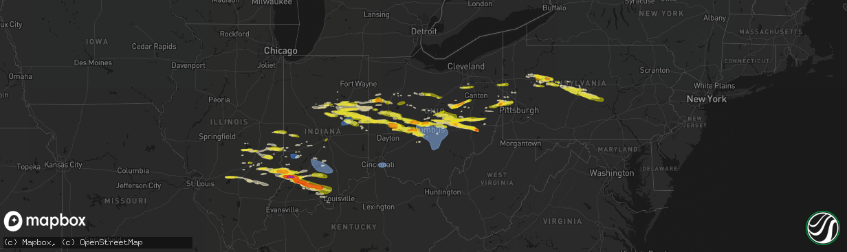
Hail
Wind
688,900
Estimated number of impacted properties by a 1.00" hail or larger19,576
Estimated number of impacted properties by a 1.75" hail or larger0
Estimated number of impacted properties by a 2.50" hail or largerStates Impacted by Hail Map on March 22, 2026
Storm reports
West Virginia
| Date | Description |
|---|---|
| 03/22/20265:41 PM CDT | Picture provided. |
| 03/22/20265:40 PM CDT | Public reported with picture via social media. |
| 03/22/20263:38 AM CDT | A tree was blown down on route 60 west blocking all of the westbound lane. |
Ohio
| Date | Description |
|---|---|
| 03/22/20266:59 PM CDT | A local report indicates 1.00 inch wind near 4 S Arlington |
| 03/22/20266:52 PM CDT | Time est from radar. |
| 03/22/20265:55 PM CDT | A local report indicates 1.00 inch wind near Quaker City |
| 03/22/20265:50 PM CDT | Public reported with picture via social media. |
| 03/22/20265:45 PM CDT | Public reported with picture via social media. |
| 03/22/20265:42 PM CDT | A local report indicates 1.00 inch wind near Old Washington |
| 03/22/20265:35 PM CDT | Public reported with picture via social media. Time estimated based off radar. |
| 03/22/20265:25 PM CDT | A local report indicates 1.00 inch wind near New Concord |
| 03/22/20265:25 PM CDT | Report from mping: quarter |
| 03/22/20265:02 PM CDT | A local report indicates 1.50 inch wind near 3 SSE Dresden |
| 03/22/20264:57 PM CDT | A local report indicates 1.00 inch wind near Dresden |
| 03/22/20264:27 PM CDT | A local report indicates 1.00 inch wind near Saint Louisville |
| 03/22/20264:17 PM CDT | A local report indicates 1.00 inch wind near Johnstown |
| 03/21/202610:25 PM CDT | Asos station kluk cincinnati lunken field. |
| 03/21/202610:05 PM CDT | Tree down along town highway 423. |
| 03/21/202610:03 PM CDT | Corrects previous tstm wnd dmg report from 3 w old washington. Several trees uprooted in backyard. |
| 03/21/202610:00 PM CDT | Tree down by junction city oh along garey rd ne. |
| 03/21/202610:00 PM CDT | Tree down along bell bottom rd and state route 668. |
| 03/21/20269:47 PM CDT | Lasted two minutes. |
| 03/21/20269:47 PM CDT | Hail lasted about 2-3 minutes. |
| 03/21/20269:47 PM CDT | Hail lasted about 2-3 minutes. |
| 03/21/20269:47 PM CDT | A local report indicates 1.75 inch wind near Heath |
| 03/21/20269:45 PM CDT | Several trees uprooted in backyard. |
| 03/21/20269:45 PM CDT | A local report indicates 1.50 inch wind near West Jefferson |
| 03/21/20269:45 PM CDT | A local report indicates 1.00 inch wind near Plain City |
| 03/21/20269:42 PM CDT | A local report indicates 1.25 inch wind near 15 W Westerville |
| 03/21/20269:40 PM CDT | A local report indicates 1.00 inch wind near London |
| 03/21/20269:30 PM CDT | Report from mping: quarter |
| 03/21/20269:30 PM CDT | Social media report of half dollar sized hail. Time estimated from radar. |
| 03/21/20269:25 PM CDT | Tree down on wires in the 14000 block of palmer road. |
| 03/21/20269:20 PM CDT | A local report indicates 1.50 inch wind near North Hampton |
| 03/21/20269:19 PM CDT | Asos station kcmh columbus john glenn international airport. |
| 03/21/20269:15 PM CDT | Awos station ktzr columbus bolton field. |
| 03/21/20269:12 PM CDT | A local report indicates 1.00 inch wind near 1 W Dublin |
| 03/21/20269:08 PM CDT | A local report indicates 1.00 inch wind near Plain City |
| 03/21/20269:02 PM CDT | Report from mping: half dollar |
| 03/21/20269:00 PM CDT | A local report indicates 1.50 inch wind near 2 E Unionville Center |
| 03/21/20268:50 PM CDT | Social media report of half dollar sized hail just south of the tusc county line. Time estimated from radar and report. |
| 03/21/20268:40 PM CDT | A local report indicates 1.00 inch wind near Bradford |
| 03/21/20268:40 PM CDT | A local report indicates 1.00 inch wind near Mount Vernon |
| 03/21/20268:34 PM CDT | A local report indicates 1.00 inch wind near West Liberty |
| 03/21/20268:25 PM CDT | A local report indicates 1.00 inch wind near 3 NW Greenville |
| 03/21/20268:20 PM CDT | Time est from radar. |
| 03/21/20268:16 PM CDT | A local report indicates 1.00 inch wind near Wilmot |
| 03/21/20268:14 PM CDT | Quarter to half dollar sized hail in glenmont. |
| 03/21/20268:10 PM CDT | A local report indicates 1.00 inch wind near 5 E Millersburg |
| 03/21/20268:08 PM CDT | Time est from radar. |
| 03/21/20268:01 PM CDT | A local report indicates 1.00 inch wind near Millersburg |
| 03/21/20268:00 PM CDT | Picture from social media. |
| 03/21/20267:54 PM CDT | A local report indicates 1.00 inch wind near 2 W Chickasaw |
| 03/21/20267:51 PM CDT | A local report indicates 1.00 inch wind near Campbell |
| 03/21/20267:50 PM CDT | A local report indicates 1.00 inch wind near Poland |
| 03/21/20267:49 PM CDT | A local report indicates 1.00 inch wind near 1 SW Mansfield |
| 03/21/20267:47 PM CDT | A local report indicates 1.00 inch wind near 2 S Mansfield |
| 03/21/20267:46 PM CDT | A local report indicates 1.00 inch wind near 1 N Lexington |
| 03/21/20267:46 PM CDT | Report from mping: quarter |
| 03/21/20267:46 PM CDT | A local report indicates 1.00 inch wind near 1 NW Poland |
| 03/21/20267:46 PM CDT | Pea sized up to quarter sized hail in mansfield. |
| 03/21/20267:45 PM CDT | A local report indicates 1.00 inch wind near Barberton |
| 03/21/20267:44 PM CDT | A local report indicates 1.00 inch wind near Mount Vernon |
| 03/21/20267:44 PM CDT | A local report indicates 1.00 inch wind near 1 NW Barberton |
| 03/21/20267:42 PM CDT | A local report indicates 1.00 inch wind near 5 E Sparta |
| 03/21/20267:40 PM CDT | A local report indicates 1.00 inch wind near 3 NNW Lexington |
| 03/21/20267:35 PM CDT | Time est from radar. |
| 03/21/20267:35 PM CDT | A local report indicates 1.00 inch wind near 2 N Galion |
| 03/21/20267:35 PM CDT | A local report indicates 1.00 inch wind near Rittman |
| 03/21/20267:30 PM CDT | A local report indicates 1.00 inch wind near 2 SW Westerville |
| 03/21/20267:29 PM CDT | A local report indicates 1.00 inch wind near 1 SSE Bucyrus |
| 03/21/20267:20 PM CDT | A local report indicates 1.00 inch wind near 1 SSW Worthington |
| 03/21/20267:20 PM CDT | A local report indicates 1.40 inch wind near Westerville |
| 03/21/20267:19 PM CDT | Time est from radar. |
| 03/21/20267:10 PM CDT | Time est from radar. |
| 03/21/20267:10 PM CDT | Time est from radar. |
| 03/21/20267:10 PM CDT | Time est from radar. |
| 03/21/20267:09 PM CDT | Time est from radar. |
Virginia
| Date | Description |
|---|---|
| 03/22/20263:37 AM CDT | Tree down near intersection of taylors gap rd and red hill rd |
| 03/22/20263:35 AM CDT | Tree down near intersection of rockfish gap turnpike and foxdale ln |
| 03/22/20263:28 AM CDT | Tree down near intersection of critzer shop rd and goodloe ln |
| 03/22/20263:12 AM CDT | Shingles peeled off roof... Multiple trees and branches down |
Kentucky
| Date | Description |
|---|---|
| 03/21/202610:20 PM CDT | Measured with the outflow boundary well ahead of thunderstorms. |
| 03/21/202610:10 PM CDT | Some tree damage and lines down as well as roof damage to an outdoor structure. Time estimated from radar with the passage of an outflow boundary from storms well to th |
Illinois
| Date | Description |
|---|---|
| 03/21/20268:23 PM CDT | Social media photo of nickel to quarter size hail. |
| 03/21/20268:20 PM CDT | Social media photo of quarter size hail. |
| 03/21/20267:57 PM CDT | A local report indicates 1.25 inch wind near Newton |
| 03/21/20267:52 PM CDT | Delayed report from heartland manor inc. Time estimated by radar. |
| 03/21/20267:45 PM CDT | Public photo of quarter size hail on social media. |
| 03/21/20267:45 PM CDT | Delayed report. Photo of quarter size hail. |
| 03/21/20267:38 PM CDT | Report from mping: quarter |
| 03/21/20267:30 PM CDT | A local report indicates 1.00 inch wind near 1 NE Paradise |
| 03/21/20267:13 PM CDT | A local report indicates 1.25 inch wind near 4 NE Shelbyville |
| 03/21/20267:11 PM CDT | A local report indicates 1.25 inch wind near 3 SE Findlay |
Pennsylvania
| Date | Description |
|---|---|
| 03/22/20266:50 PM CDT | Report from mping. |
| 03/22/20266:43 PM CDT | Quarter sized hail in philipsburg. |
| 03/22/20266:38 PM CDT | Report from mping: quarter |
| 03/22/20266:37 PM CDT | Report from mping: quarter |
| 03/22/20265:59 PM CDT | Report from mping: quarter |
| 03/22/20265:57 PM CDT | A local report indicates 1.00 inch wind near 3 WNW Aliquippa |
| 03/22/20265:56 PM CDT | A local report indicates 1.00 inch wind near Brookville |
| 03/22/20265:53 PM CDT | Hail ranging from marble to golf ball size. |
| 03/22/20265:09 PM CDT | Trees down on wires in milesburg. |
| 03/22/20265:00 PM CDT | Public reported with picture via social media. |
| 03/22/20264:53 PM CDT | Trees down across penns cave road. |
| 03/22/20264:42 PM CDT | Trees and wires down along high street extension. |
| 03/22/20264:20 PM CDT | Trees and wires down at 1321 frog hollow road. |
| 03/22/20264:16 PM CDT | Trees down across drane hwy. |
| 03/22/20264:02 PM CDT | Public reported 1 inch hail in clarion... Pa. |
| 03/22/20264:02 PM CDT | Report from mping: ping pong ball |
| 03/22/20264:00 PM CDT | A local report indicates 1.25 inch wind near Strattanville |
| 03/22/20263:48 PM CDT | Trees down on wires along pine creek hollow road. |
| 03/22/20263:45 PM CDT | Trees down on wires along ingleby road. |
| 03/22/20263:42 PM CDT | Tree blocking roadway at 216 north street. |
| 03/22/20263:25 PM CDT | Trees down on wires on berry road. |
| 03/21/20269:01 PM CDT | Three trees blown down on to us-30... Causing road closure. |
| 03/21/20268:00 PM CDT | Public reported with picture via social media. |
| 03/21/20267:21 PM CDT | Quarter sized hail in reedsville. |
| 03/21/20267:13 PM CDT | Report from mping. |
| 03/21/20267:07 PM CDT | Report from mping. |
| 03/21/20267:07 PM CDT | A local report indicates 1.00 inch wind near 2 SSW State College |
| 03/21/20267:03 PM CDT | Report from mping: quarter |
| 03/21/20267:02 PM CDT | Report from mping: quarter |
| 03/21/20267:02 PM CDT | Report from mping: quarter |
| 03/21/20267:01 PM CDT | Report from mping: quarter |
| 03/21/20267:00 PM CDT | Hail. Largest is one inch. Hail covering the ground. |
Indiana
| Date | Description |
|---|---|
| 03/22/20266:55 PM CDT | A local report indicates 1.00 inch wind near 6 NE Kokomo |
| 03/22/20266:41 PM CDT | Public report of 1 hail north of marion city limits at 741 pm. Delayed report. |
| 03/22/20266:22 PM CDT | Video on facebook showing hail mainly between dime to penny size with a few quarters mixed in. Time estimated via radar. Delayed report. |
| 03/22/20266:18 PM CDT | Photo relayed by emergency management of hail that appears to be quarter size in galveston. Time estimated via radar. |
| 03/21/20269:53 PM CDT | Corrects location of previous late report of multiple trees downed by t-storm winds. |
| 03/21/20269:48 PM CDT | Late report of multiple trees downed by t-storm winds. Time estd from radar. |
| 03/21/20269:33 PM CDT | Late report of t-storm winds blowing out transformer. Winds also downed power pole southwest of mitchell. Time estd from radar. |
| 03/21/20269:33 PM CDT | Late report of t-storm winds blowing out transformer. T-storm winds downed power pole southwest of mitchell. Time estd from radar. |
| 03/21/20269:29 PM CDT | A local report indicates 64 MPH wind near 2 S Spurgeons Corner |
| 03/21/20269:20 PM CDT | A local report indicates 1.75 inch wind near 2 S Whitfield |
| 03/21/20269:13 PM CDT | Time estimated from radar. |
| 03/21/20269:04 PM CDT | Time estimated from radar. |
| 03/21/20269:02 PM CDT | Multiple reports of 1.00 inch hail in greenfield. |
| 03/21/20269:01 PM CDT | Corrects time of previous report for this location. Time estd from radar. |
| 03/21/20269:01 PM CDT | Corrects time of previous report for this location. |
| 03/21/20268:59 PM CDT | Time estimated from radar. |
| 03/21/20268:54 PM CDT | Time estimated from radar. |
| 03/21/20268:45 PM CDT | A local report indicates 1.00 inch wind near 1 W Franklin |
| 03/21/20268:45 PM CDT | Late report of numerous public photos of 1.8 to 2.0 inch hail in bicknell area. Time estd from radar. |
| 03/21/20268:45 PM CDT | Numerous public photos of 1.8 to 2.0 inch hail in bicknell area. Time estd from radar. |
| 03/21/20268:45 PM CDT | Multiple photos of 1.3-1.7 inch hail in bicknell. Time estd from radar. |
| 03/21/20268:42 PM CDT | A local report indicates 1.00 inch wind near 2 NE Prairie Creek Rese |
| 03/21/20268:42 PM CDT | Time estimated from radar. |
| 03/21/20268:36 PM CDT | A local report indicates 1.00 inch wind near 1 NE Ball State Univers |
| 03/21/20268:34 PM CDT | Time estimated from radar. Also 0.75 inch hail. |
| 03/21/20268:33 PM CDT | Also e60 mph gust. Hail 1.25 to 1.50. |
| 03/21/20268:33 PM CDT | Time estimated from radar. Winds 25 mph. |
| 03/21/20268:26 PM CDT | Also pea hail. |
| 03/21/20268:24 PM CDT | Time estimated from radar. |
| 03/21/20268:19 PM CDT | A local report indicates 1.00 inch wind near 3 S Anderson |
| 03/21/20268:13 PM CDT | Late report of tree downed by t-storm winds on county road 850 east. Time estd from radar. |
| 03/21/20268:13 PM CDT | A local report indicates 1.00 inch wind near 4 W Union City |
| 03/21/20268:09 PM CDT | Late report of power lines down by thunderstorm winds. Time estd from radar. |
| 03/21/20268:06 PM CDT | Public photo. Time estd from radar. |
| 03/21/20268:06 PM CDT | Late report. Public photo. Time estd from radar. |
| 03/21/20268:05 PM CDT | Report from mping: quarter |
| 03/21/20267:59 PM CDT | A local report indicates 1.25 inch wind near 2 SE Sharpsville |
| 03/21/20267:54 PM CDT | Report from mping: quarter |
| 03/21/20267:54 PM CDT | A local report indicates 1.25 inch wind near 1 ESE Albany |
| 03/21/20267:53 PM CDT | A local report indicates 1.00 inch wind near 4 ESE Royerton |
| 03/21/20267:35 PM CDT | Report from mping: quarter |
| 03/21/20267:33 PM CDT | A local report indicates 1.00 inch wind near 2 S Hackleman |
| 03/21/20267:30 PM CDT | Video on x with report of pea to dime sized hail with quarters mixed in. Hail occurred from 830 to 835 pm. |
| 03/21/20267:25 PM CDT | Photo on facebook of what appears to quarter size hail near portland. Time estimated via radar. Delayed report. |
| 03/21/20267:19 PM CDT | Report from mping: quarter |
| 03/21/20267:17 PM CDT | Time estimated via radar. |
| 03/21/20267:16 PM CDT | A local report indicates 1.25 inch wind near Hartford City |
| 03/21/20267:15 PM CDT | Photo on facebook showing hail up to 1.5 inches in diameter. Delayed report. |
| 03/21/20267:13 PM CDT | A local report indicates 1.00 inch wind near 2 S Upland |
| 03/21/20267:10 PM CDT | Photo on facebook showing around quarter size hail east of upland. Delayed report. Time estimated via radar. |
| 03/21/20267:10 PM CDT | A local report indicates 1.00 inch wind near 3 NNW Shamrock Lakes |
| 03/21/20267:06 PM CDT | Photo on facebook shows quarter size hail. Time estimated via radar. |
Cities Impacted by Hail Map on March 22, 2026
- Spring Mills, PA
- Clarion, PA
- Shippenville, PA
- Sligo, PA
- Summerville, PA
- Strattanville, PA
- Corsica, PA
- Brookville, PA
- Johnstown, OH
- Grampian, PA
- Sunbury, OH
- Newark, OH
- Utica, OH
- Granville, OH
- West Decatur, PA
- Morrisdale, PA
- Wallaceton, PA
- Bigler, PA
- Woodland, PA
- Allport, PA
- Hawk Run, PA
- Munson, PA
- Philipsburg, PA
- Saint Louisville, OH
- Winburne, PA
- Lanse, PA
- Alexandria, OH
- Mineral Springs, PA
- Clearfield, PA
- Hopedale, OH
- Scio, OH
- Jewett, OH
- Bellefonte, PA
- Port Matilda, PA
- State College, PA
- Julian, PA
- University Park, PA
- Reynoldsville, PA
- Knox, PA
- Parker, PA
- Emlenton, PA
- Nashport, OH
- Dresden, OH
- Frazeysburg, OH
- Du Bois, PA
- Rockton, PA
- Trinway, OH
- New Bethlehem, PA
- Fairmount City, PA
- Mayport, PA
- Zanesville, OH
- Adamsville, OH
- Coshocton, OH
- Cambridge, OH
- New Concord, OH
- Norwich, OH
- Kennerdell, PA
- Luthersburg, PA
- Marble, PA
- Venus, PA
- Cranberry, PA
- Sykesville, PA
- Irondale, OH
- Bergholz, OH
- New Cumberland, WV
- Wellsville, OH
- Hammondsville, OH
- Newell, WV
- Salineville, OH
- Toronto, OH
- Chester, WV
- Hookstown, PA
- Georgetown, PA
- Sigel, PA
- Clarington, PA
- Lucinda, PA
- Kossuth, PA
- Industry, PA
- Osceola Mills, PA
- Kipling, OH
- Byesville, OH
- Lore City, OH
- Senecaville, OH
- Aliquippa, PA
- Shippingport, PA
- Monaca, PA
- Brockway, PA
- Conway, PA
- Baden, PA
- Sewickley, PA
- Freedom, PA
- Ambridge, PA
- East Liverpool, OH
- Carrollton, OH
- Salesville, OH
- Quaker City, OH
- Bloomingdale, OH
- Troutville, PA
- Punxsutawney, PA
- Knox Dale, PA
- Falls Creek, PA
- Hyde, PA
- Curwensville, PA
- Galveston, IN
- Flora, IN
- Kokomo, IN
- Walton, IN
- Bunker Hill, IN
- Miami, IN
- Rimersburg, PA
- Callensburg, PA
- Olanta, PA
- Glen Richey, PA
- Houtzdale, PA
- Harmony, PA
- Midland, PA
- Ellwood City, PA
- Fombell, PA
- Marion, IN
- Richmond, OH
- Stratton, OH
- Weirton, WV
- Amsterdam, OH
- Converse, IN
- Clinton, PA
- Imperial, PA
- Swayzee, IN
- Sweetser, IN
- Van Buren, IN
- Celina, OH
- Rockford, OH
- Mendon, OH
- Spencerville, OH
- Venedocia, OH
- Saint Marys, OH
- Wapakoneta, OH
- Montpelier, IN
- Warren, IN
- Hartford City, IN
- Jonesboro, IN
- Gas City, IN
- Fairmount, IN
- Hawthorn, PA
- Amboy, IN
- Greentown, IN
- Moshannon, PA
- Camden, IN
- Prospect, PA
- Delphi, IN
- Bringhurst, IN
- Frenchville, PA
- Centre Hall, PA
- Huntingdon, PA
- Boalsburg, PA
- Lemont, PA
- Columbus, OH
- Dublin, OH
- Powell, OH
- Keystone, IN
- Poneto, IN
- Fowlerton, IN
- Upland, IN
- Reedsville, PA
- Milroy, PA
- Lima, OH
- Beaverdam, OH
- Columbus Grove, OH
- Bluffton, OH
- Delphos, OH
- Van Wert, OH
- Buckland, OH
- Shelbyville, IL
- Bluffton, IN
- Forest, OH
- Galena, OH
- Lewis Center, OH
- Portersville, PA
- Dunkirk, OH
- Upper Sandusky, OH
- Ada, OH
- Findlay, IL
- Westerville, OH
- Pennville, IN
- Portland, IN
- Dunkirk, IN
- Indianola, IL
- Sidell, IL
- Georgetown, IL
- Ridge Farm, IL
- Chrisman, IL
- Windsor, IL
- Mattoon, IL
- Bethany, IL
- Windfall, IN
- Elwood, IN
- Nevada, OH
- Bucyrus, OH
- Gays, IL
- Bryant, IN
- Burlington, IN
- Cutler, IN
- Russiaville, IN
- Metcalf, IL
- Centerburg, OH
- Berne, IN
- Geneva, IN
- Charleston, IL
- Westfield, IL
- Ashmore, IL
- Uniopolis, OH
- Summitville, IN
- Gaston, IN
- Coburn, PA
- Beaver Springs, PA
- Lewistown, PA
- Richfield, PA
- Mifflintown, PA
- McClure, PA
- McAlisterville, PA
- Greenville, IL
- Keyesport, IL
- Vandalia, IL
- Kansas, IL
- Martinsville, IL
- Marshall, IL
- Paris, IL
- Dennison, IL
- Muncie, IN
- Matthews, IN
- Eaton, IN
- Albany, IN
- Barberton, OH
- Doylestown, OH
- Rittman, OH
- Wadsworth, OH
- Sterling, OH
- Fort Recovery, OH
- Coldwater, OH
- Crestline, OH
- Galion, OH
- Terre Haute, IN
- Pataskala, OH
- Lerna, IL
- Greenup, IL
- Toledo, IL
- Trilla, IL
- Akron, OH
- Willshire, OH
- New Albany, OH
- Altamont, IL
- Beecher City, IL
- Cayuga, IN
- Dana, IN
- Lakewood, IL
- Clinton, OH
- Tiro, OH
- Sycamore, OH
- Mansfield, OH
- Shelby, OH
- Mount Vernon, OH
- Howard, OH
- Gambier, OH
- Effingham, IL
- Wheeler, IL
- Newton, IL
- Patoka, IL
- Vernon, IL
- Redkey, IN
- Ridgeville, IN
- Farmland, IN
- Parker City, IN
- Casey, IL
- Yorkshire, OH
- Maria Stein, OH
- Minster, OH
- Fort Loramie, OH
- Brinkhaven, OH
- Glenmont, OH
- Killbuck, OH
- La Rue, OH
- Mount Victory, OH
- Tipton, IN
- Sharpsville, IN
- Lowellville, OH
- Edinburg, PA
- Pulaski, PA
- Bloomingdale, IN
- Rockville, IN
- Marshall, IN
- Brazil, IN
- Carbon, IN
- Montezuma, IN
- Saint Henry, OH
- Alma, IL
- Hillsdale, IN
- Willow Hill, IL
- Saratoga, IN
- Winchester, IN
- Selma, IN
- Union City, IN
- Sidney, OH
- Anna, OH
- Pemberton, OH
- Port Jefferson, OH
- Quincy, OH
- Maplewood, OH
- Jackson Center, OH
- Millersburg, OH
- Wilmot, OH
- Fredericksburg, OH
- Dundee, OH
- Navarre, OH
- Beach City, OH
- Big Prairie, OH
- Danville, OH
- Lakeville, OH
- Greencastle, IN
- Fillmore, IN
- Oblong, IL
- Sumner, IL
- Loudonville, OH
- Youngstown, OH
- Struthers, OH
- Kinmundy, IL
- Cloverdale, IN
- Reelsville, IN
- West Terre Haute, IN
- Centerpoint, IN
- Mason, IL
- Warsaw, OH
- Strasburg, OH
- Bolivar, OH
- Holmesville, OH
- Conesville, OH
- West Liberty, OH
- Urbana, OH
- Bellefontaine, OH
- De Graff, OH
- Greenville, OH
- Ansonia, OH
- Union City, OH
- Flat Rock, IL
- Robinson, IL
- Palestine, IL
- Bradford, OH
- Marengo, OH
- Ashley, OH
- Cardington, OH
- West Lafayette, OH
- Jewett, IL
- Sugarcreek, OH
- Waldo, OH
- Delaware, OH
- Flora, IL
- Xenia, IL
- Louisville, IL
- Kenton, OH
- Alexandria, IN
- Saint Elmo, IL
- Teutopolis, IL
- Dieterich, IL
- West Liberty, IL
- Dundas, IL
- Iuka, IL
- Bowling Green, IN
- Freedom, IN
- Coal City, IN
- Clay City, IN
- Watson, IL
- Stilesville, IN
- Coatesville, IN
- Montrose, IL
- Cory, IN
- Pimento, IN
- Lewis, IN
- Carlisle, IN
- Merom, IN
- Oaktown, IN
- Lawrenceville, IL
- Bruceville, IN
- Edwardsport, IN
- Sandborn, IN
- Westphalia, IN
- Freelandville, IN
- Lyons, IN
- Bicknell, IN
- Ragsdale, IN
- New Philadelphia, OH
- Anderson, IN
- Yorktown, IN
- Daleville, IN
- North Lewisburg, OH
- Cable, OH
- Mingo, OH
- Plainfield, OH
- Kimbolton, OH
- Newcomerstown, OH
- Versailles, OH
- Sparta, OH
- Fredericktown, OH
- Covington, OH
- Harrod, OH
- Waynesfield, OH
- Noble, IL
- Clay City, IL
- Belle Center, OH
- Sullivan, IN
- Kempton, IN
- Patricksburg, IN
- Freeport, OH
- Port Washington, OH
- Tippecanoe, OH
- Modoc, IN
- Losantville, IN
- Walhonding, OH
- Martinsburg, OH
- Beaver Falls, PA
- Rosewood, OH
- Conover, OH
- Saint Paris, OH
- Parkersburg, IL
- Olney, IL
- Calhoun, IL
- Mount Erie, IL
- Washington, IN
- Russia, OH
- Houston, OH
- Piqua, OH
- Bridgeport, IL
- Vincennes, IN
- Troy, OH
- Fletcher, OH
- Milford Center, OH
- Marysville, OH
- Mechanicsburg, OH
- Woodstock, OH
- Irwin, OH
- Plain City, OH
- Plainville, IN
- Ellettsville, IN
- Bloomington, IN
- Casstown, OH
- Elnora, IN
- Zanesfield, OH
- Hilliard, OH
- Amlin, OH
- Odon, IN
- Newberry, IN
- Wheatland, IN
- Montgomery, IN
- Crane, IN
- Loogootee, IN
- Cannelburg, IN
- Shoals, IN
- Gettysburg, OH
- North Hampton, OH
- New Carlisle, OH
- Christiansburg, OH
- Tremont City, OH
- Springfield, OH
- Rogers, OH
- Lisbon, OH
- Darlington, PA
- Fountain City, IN
- Richmond, IN
- Bargersville, IN
- Owensburg, IN
- Bloomfield, IN
- Scotland, IN
- Unionville, IN
- Shreve, OH
- Nashville, IN
- Flushing, OH
- Martinsville, IN
- Cadiz, OH
- Richwood, OH
- Prospect, OH
- Fresno, OH
- Williams, IN
- Bedford, IN
- Monrovia, IN
- South Vienna, OH
- Piedmont, OH
- London, OH
- Catawba, OH
- South Charleston, OH
- West Jefferson, OH
- Galloway, OH
- Blacklick, OH
- Orient, OH
- Grove City, OH
- Commercial Point, OH
- Ashville, OH
- Lockbourne, OH
- Groveport, OH
- Reynoldsburg, OH
- Carroll, OH
- Kirkersville, OH
- Pickerington, OH
- Amanda, OH
- Lancaster, OH
- Buckeye Lake, OH
- Millersport, OH
- Hebron, OH
- Etna, OH
- Canal Winchester, OH
- Stoutsville, OH
- Baltimore, OH
- Heath, OH
- Lithopolis, OH
- Heltonville, IN
- Norman, IN
- Columbus, IN
- Brownstown, IN
- Medora, IN
- Freetown, IN
- Seymour, IN
- West Baden Springs, IN
- French Lick, IN
- Dubois, IN
- Mitchell, IN
- Jasper, IN
- Paoli, IN
- Orleans, IN
- Hardinsburg, IN
- Oolitic, IN
- Vallonia, IN
- Mount Sterling, OH
- Harrisburg, OH
- Glenford, OH
- Pleasantville, OH
- Bremen, OH
- Somerset, OH
- Rushville, OH
- Mount Perry, OH
- Laurelville, OH
- Jacksontown, OH
- Thornville, OH
- Tarlton, OH
- Sugar Grove, OH
- Thurston, OH
- Kingston, OH
- Circleville, OH
- Rockbridge, OH
- Fredericksburg, IN
- Salem, IN
- Campbellsburg, IN
- Creston, OH
- Seville, OH
- Oakland, IL
- Marengo, IN
- Williamsport, OH
- Milltown, IN
- Pennsylvania Furnace, PA
- Palmyra, IN
- Depauw, IN
- Pekin, IN
- Greenville, IN
- Borden, IN
- Ramsey, IN
- English, IN
- Corydon, IN
- New Middletown, IN
- Elizabeth, IN
- Stump Creek, PA
- New Salisbury, IN
- New Castle, PA
- Campbell, OH
- New Wilmington, PA
- Uniontown, OH
- Bowerston, OH
- Silver Grove, KY
- Cincinnati, OH
- Dayton, KY
- Fort Thomas, KY
- Newport, KY
- Melbourne, KY
- Amelia, OH
- Milford, OH
- Batavia, OH
- Bellevue, KY
- Middletown, IN
- Mooreland, IN
- Lynn, IN
- Williamsburg, IN
- Mooresville, IN
- Plainfield, IN
- Clayton, IN
- Indianapolis, IN
- Greenwood, IN
- Beech Grove, IN
- Avon, IN
- Franklin, IN
- Ringgold, PA
- Morgantown, IN
- Nineveh, IN
- Trafalgar, IN
- Leetsdale, PA
- Crescent, PA
- South Heights, PA
- La Fontaine, IN
- Wabash, IN
- Urbana, IN