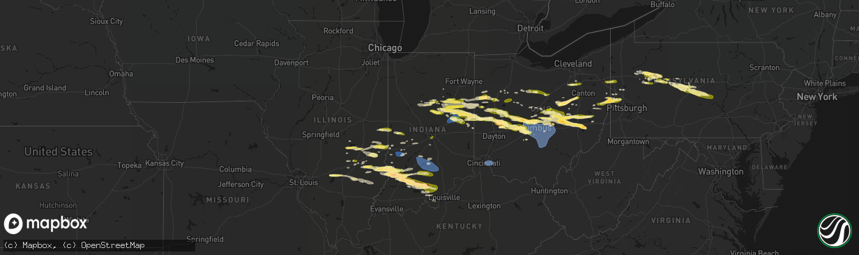
Hail Map in Indiana on March 22, 2026
The weather event in Indiana on March 22, 2026 includes Hail and Wind maps. 6 states and 603 cities were impacted and suffered possible damage. The total estimated number of properties impacted is 149,572.
Hail
Wind
149,572
Estimated number of impacted properties by a 1.00" hail or larger19,293
Estimated number of impacted properties by a 1.75" hail or larger0
Estimated number of impacted properties by a 2.50" hail or largerStorm reports in Indiana
Indiana
| Date | Description |
|---|---|
| 03/22/20266:55 PM CDT | A local report indicates 1.00 inch wind near 6 NE Kokomo |
| 03/22/20266:41 PM CDT | Public report of 1 hail north of marion city limits at 741 pm. Delayed report. |
| 03/22/20266:22 PM CDT | Video on facebook showing hail mainly between dime to penny size with a few quarters mixed in. Time estimated via radar. Delayed report. |
| 03/22/20266:18 PM CDT | Photo relayed by emergency management of hail that appears to be quarter size in galveston. Time estimated via radar. |
| 03/21/20269:53 PM CDT | Corrects location of previous late report of multiple trees downed by t-storm winds. |
| 03/21/20269:48 PM CDT | Late report of multiple trees downed by t-storm winds. Time estd from radar. |
| 03/21/20269:33 PM CDT | Late report of t-storm winds blowing out transformer. Winds also downed power pole southwest of mitchell. Time estd from radar. |
| 03/21/20269:33 PM CDT | Late report of t-storm winds blowing out transformer. T-storm winds downed power pole southwest of mitchell. Time estd from radar. |
| 03/21/20269:29 PM CDT | A local report indicates 64 MPH wind near 2 S Spurgeons Corner |
| 03/21/20269:20 PM CDT | A local report indicates 1.75 inch wind near 2 S Whitfield |
| 03/21/20269:13 PM CDT | Time estimated from radar. |
| 03/21/20269:04 PM CDT | Time estimated from radar. |
| 03/21/20269:02 PM CDT | Multiple reports of 1.00 inch hail in greenfield. |
| 03/21/20269:01 PM CDT | Corrects time of previous report for this location. |
| 03/21/20269:01 PM CDT | Corrects time of previous report for this location. Time estd from radar. |
| 03/21/20268:59 PM CDT | Time estimated from radar. |
| 03/21/20268:54 PM CDT | Time estimated from radar. |
| 03/21/20268:45 PM CDT | Numerous public photos of 1.8 to 2.0 inch hail in bicknell area. Time estd from radar. |
| 03/21/20268:45 PM CDT | A local report indicates 1.00 inch wind near 1 W Franklin |
| 03/21/20268:45 PM CDT | Late report of numerous public photos of 1.8 to 2.0 inch hail in bicknell area. Time estd from radar. |
| 03/21/20268:45 PM CDT | Multiple photos of 1.3-1.7 inch hail in bicknell. Time estd from radar. |
| 03/21/20268:42 PM CDT | A local report indicates 1.00 inch wind near 2 NE Prairie Creek Rese |
| 03/21/20268:42 PM CDT | Time estimated from radar. |
| 03/21/20268:36 PM CDT | A local report indicates 1.00 inch wind near 1 NE Ball State Univers |
| 03/21/20268:34 PM CDT | Time estimated from radar. Also 0.75 inch hail. |
| 03/21/20268:33 PM CDT | Also e60 mph gust. Hail 1.25 to 1.50. |
| 03/21/20268:33 PM CDT | Time estimated from radar. Winds 25 mph. |
| 03/21/20268:26 PM CDT | Also pea hail. |
| 03/21/20268:24 PM CDT | Time estimated from radar. |
| 03/21/20268:19 PM CDT | A local report indicates 1.00 inch wind near 3 S Anderson |
| 03/21/20268:13 PM CDT | A local report indicates 1.00 inch wind near 4 W Union City |
| 03/21/20268:13 PM CDT | Late report of tree downed by t-storm winds on county road 850 east. Time estd from radar. |
| 03/21/20268:09 PM CDT | Late report of power lines down by thunderstorm winds. Time estd from radar. |
| 03/21/20268:06 PM CDT | Late report. Public photo. Time estd from radar. |
| 03/21/20268:06 PM CDT | Public photo. Time estd from radar. |
| 03/21/20268:05 PM CDT | Report from mping: quarter |
| 03/21/20267:59 PM CDT | A local report indicates 1.25 inch wind near 2 SE Sharpsville |
| 03/21/20267:54 PM CDT | A local report indicates 1.25 inch wind near 1 ESE Albany |
| 03/21/20267:54 PM CDT | Report from mping: quarter |
| 03/21/20267:53 PM CDT | A local report indicates 1.00 inch wind near 4 ESE Royerton |
| 03/21/20267:35 PM CDT | Report from mping: quarter |
| 03/21/20267:33 PM CDT | A local report indicates 1.00 inch wind near 2 S Hackleman |
| 03/21/20267:30 PM CDT | Video on x with report of pea to dime sized hail with quarters mixed in. Hail occurred from 830 to 835 pm. |
| 03/21/20267:25 PM CDT | Photo on facebook of what appears to quarter size hail near portland. Time estimated via radar. Delayed report. |
| 03/21/20267:19 PM CDT | Report from mping: quarter |
| 03/21/20267:17 PM CDT | Time estimated via radar. |
| 03/21/20267:16 PM CDT | A local report indicates 1.25 inch wind near Hartford City |
| 03/21/20267:15 PM CDT | Photo on facebook showing hail up to 1.5 inches in diameter. Delayed report. |
| 03/21/20267:13 PM CDT | A local report indicates 1.00 inch wind near 2 S Upland |
| 03/21/20267:10 PM CDT | Photo on facebook showing around quarter size hail east of upland. Delayed report. Time estimated via radar. |
| 03/21/20267:10 PM CDT | A local report indicates 1.00 inch wind near 3 NNW Shamrock Lakes |
| 03/21/20267:06 PM CDT | Photo on facebook shows quarter size hail. Time estimated via radar. |
All States Impacted by Hail Map on March 22, 2026
Cities Impacted by Hail Map on March 22, 2026
- Spring Mills, PA
- Clarion, PA
- Shippenville, PA
- Sligo, PA
- Summerville, PA
- Strattanville, PA
- Corsica, PA
- Brookville, PA
- Johnstown, OH
- Grampian, PA
- Sunbury, OH
- Newark, OH
- Utica, OH
- Granville, OH
- West Decatur, PA
- Morrisdale, PA
- Wallaceton, PA
- Bigler, PA
- Woodland, PA
- Allport, PA
- Hawk Run, PA
- Munson, PA
- Philipsburg, PA
- Saint Louisville, OH
- Winburne, PA
- Lanse, PA
- Alexandria, OH
- Mineral Springs, PA
- Clearfield, PA
- Hopedale, OH
- Scio, OH
- Jewett, OH
- Bellefonte, PA
- Port Matilda, PA
- State College, PA
- Julian, PA
- University Park, PA
- Reynoldsville, PA
- Knox, PA
- Parker, PA
- Emlenton, PA
- Nashport, OH
- Dresden, OH
- Frazeysburg, OH
- Du Bois, PA
- Rockton, PA
- Trinway, OH
- New Bethlehem, PA
- Fairmount City, PA
- Mayport, PA
- Zanesville, OH
- Adamsville, OH
- Coshocton, OH
- Cambridge, OH
- New Concord, OH
- Norwich, OH
- Kennerdell, PA
- Luthersburg, PA
- Marble, PA
- Venus, PA
- Cranberry, PA
- Sykesville, PA
- Irondale, OH
- Bergholz, OH
- New Cumberland, WV
- Wellsville, OH
- Hammondsville, OH
- Newell, WV
- Salineville, OH
- Toronto, OH
- Chester, WV
- Hookstown, PA
- Georgetown, PA
- Sigel, PA
- Clarington, PA
- Lucinda, PA
- Kossuth, PA
- Industry, PA
- Osceola Mills, PA
- Kipling, OH
- Byesville, OH
- Lore City, OH
- Senecaville, OH
- Aliquippa, PA
- Shippingport, PA
- Monaca, PA
- Brockway, PA
- Conway, PA
- Baden, PA
- Sewickley, PA
- Freedom, PA
- Ambridge, PA
- East Liverpool, OH
- Carrollton, OH
- Salesville, OH
- Quaker City, OH
- Bloomingdale, OH
- Troutville, PA
- Punxsutawney, PA
- Knox Dale, PA
- Falls Creek, PA
- Hyde, PA
- Curwensville, PA
- Galveston, IN
- Flora, IN
- Kokomo, IN
- Walton, IN
- Bunker Hill, IN
- Miami, IN
- Rimersburg, PA
- Callensburg, PA
- Olanta, PA
- Glen Richey, PA
- Houtzdale, PA
- Harmony, PA
- Midland, PA
- Ellwood City, PA
- Fombell, PA
- Marion, IN
- Richmond, OH
- Stratton, OH
- Weirton, WV
- Amsterdam, OH
- Converse, IN
- Clinton, PA
- Imperial, PA
- Swayzee, IN
- Sweetser, IN
- Van Buren, IN
- Celina, OH
- Rockford, OH
- Mendon, OH
- Spencerville, OH
- Venedocia, OH
- Saint Marys, OH
- Wapakoneta, OH
- Montpelier, IN
- Warren, IN
- Hartford City, IN
- Jonesboro, IN
- Gas City, IN
- Fairmount, IN
- Hawthorn, PA
- Amboy, IN
- Greentown, IN
- Moshannon, PA
- Camden, IN
- Prospect, PA
- Delphi, IN
- Bringhurst, IN
- Frenchville, PA
- Centre Hall, PA
- Huntingdon, PA
- Boalsburg, PA
- Lemont, PA
- Columbus, OH
- Dublin, OH
- Powell, OH
- Keystone, IN
- Poneto, IN
- Fowlerton, IN
- Upland, IN
- Reedsville, PA
- Milroy, PA
- Lima, OH
- Beaverdam, OH
- Columbus Grove, OH
- Bluffton, OH
- Delphos, OH
- Van Wert, OH
- Buckland, OH
- Shelbyville, IL
- Bluffton, IN
- Forest, OH
- Galena, OH
- Lewis Center, OH
- Portersville, PA
- Dunkirk, OH
- Upper Sandusky, OH
- Ada, OH
- Findlay, IL
- Westerville, OH
- Pennville, IN
- Portland, IN
- Dunkirk, IN
- Indianola, IL
- Sidell, IL
- Georgetown, IL
- Ridge Farm, IL
- Chrisman, IL
- Windsor, IL
- Mattoon, IL
- Bethany, IL
- Windfall, IN
- Elwood, IN
- Nevada, OH
- Bucyrus, OH
- Gays, IL
- Bryant, IN
- Burlington, IN
- Cutler, IN
- Russiaville, IN
- Metcalf, IL
- Centerburg, OH
- Berne, IN
- Geneva, IN
- Charleston, IL
- Westfield, IL
- Ashmore, IL
- Uniopolis, OH
- Summitville, IN
- Gaston, IN
- Coburn, PA
- Beaver Springs, PA
- Lewistown, PA
- Richfield, PA
- Mifflintown, PA
- McClure, PA
- McAlisterville, PA
- Greenville, IL
- Keyesport, IL
- Vandalia, IL
- Kansas, IL
- Martinsville, IL
- Marshall, IL
- Paris, IL
- Dennison, IL
- Muncie, IN
- Matthews, IN
- Eaton, IN
- Albany, IN
- Barberton, OH
- Doylestown, OH
- Rittman, OH
- Wadsworth, OH
- Sterling, OH
- Fort Recovery, OH
- Coldwater, OH
- Crestline, OH
- Galion, OH
- Terre Haute, IN
- Pataskala, OH
- Lerna, IL
- Greenup, IL
- Toledo, IL
- Trilla, IL
- Akron, OH
- Willshire, OH
- New Albany, OH
- Altamont, IL
- Beecher City, IL
- Cayuga, IN
- Dana, IN
- Lakewood, IL
- Clinton, OH
- Tiro, OH
- Sycamore, OH
- Mansfield, OH
- Shelby, OH
- Mount Vernon, OH
- Howard, OH
- Gambier, OH
- Effingham, IL
- Wheeler, IL
- Newton, IL
- Patoka, IL
- Vernon, IL
- Redkey, IN
- Ridgeville, IN
- Farmland, IN
- Parker City, IN
- Casey, IL
- Yorkshire, OH
- Maria Stein, OH
- Minster, OH
- Fort Loramie, OH
- Brinkhaven, OH
- Glenmont, OH
- Killbuck, OH
- La Rue, OH
- Mount Victory, OH
- Tipton, IN
- Sharpsville, IN
- Lowellville, OH
- Edinburg, PA
- Pulaski, PA
- Bloomingdale, IN
- Rockville, IN
- Marshall, IN
- Brazil, IN
- Carbon, IN
- Montezuma, IN
- Saint Henry, OH
- Alma, IL
- Hillsdale, IN
- Willow Hill, IL
- Saratoga, IN
- Winchester, IN
- Selma, IN
- Union City, IN
- Sidney, OH
- Anna, OH
- Pemberton, OH
- Port Jefferson, OH
- Quincy, OH
- Maplewood, OH
- Jackson Center, OH
- Millersburg, OH
- Wilmot, OH
- Fredericksburg, OH
- Dundee, OH
- Navarre, OH
- Beach City, OH
- Big Prairie, OH
- Danville, OH
- Lakeville, OH
- Greencastle, IN
- Fillmore, IN
- Oblong, IL
- Sumner, IL
- Loudonville, OH
- Youngstown, OH
- Struthers, OH
- Kinmundy, IL
- Cloverdale, IN
- Reelsville, IN
- West Terre Haute, IN
- Centerpoint, IN
- Mason, IL
- Warsaw, OH
- Strasburg, OH
- Bolivar, OH
- Holmesville, OH
- Conesville, OH
- West Liberty, OH
- Urbana, OH
- Bellefontaine, OH
- De Graff, OH
- Greenville, OH
- Ansonia, OH
- Union City, OH
- Flat Rock, IL
- Robinson, IL
- Palestine, IL
- Bradford, OH
- Marengo, OH
- Ashley, OH
- Cardington, OH
- West Lafayette, OH
- Jewett, IL
- Sugarcreek, OH
- Waldo, OH
- Delaware, OH
- Flora, IL
- Xenia, IL
- Louisville, IL
- Kenton, OH
- Alexandria, IN
- Saint Elmo, IL
- Teutopolis, IL
- Dieterich, IL
- West Liberty, IL
- Dundas, IL
- Iuka, IL
- Bowling Green, IN
- Freedom, IN
- Coal City, IN
- Clay City, IN
- Watson, IL
- Stilesville, IN
- Coatesville, IN
- Montrose, IL
- Cory, IN
- Pimento, IN
- Lewis, IN
- Carlisle, IN
- Merom, IN
- Oaktown, IN
- Lawrenceville, IL
- Bruceville, IN
- Edwardsport, IN
- Sandborn, IN
- Westphalia, IN
- Freelandville, IN
- Lyons, IN
- Bicknell, IN
- Ragsdale, IN
- New Philadelphia, OH
- Anderson, IN
- Yorktown, IN
- Daleville, IN
- North Lewisburg, OH
- Cable, OH
- Mingo, OH
- Plainfield, OH
- Kimbolton, OH
- Newcomerstown, OH
- Versailles, OH
- Sparta, OH
- Fredericktown, OH
- Covington, OH
- Harrod, OH
- Waynesfield, OH
- Noble, IL
- Clay City, IL
- Belle Center, OH
- Sullivan, IN
- Kempton, IN
- Patricksburg, IN
- Freeport, OH
- Port Washington, OH
- Tippecanoe, OH
- Modoc, IN
- Losantville, IN
- Walhonding, OH
- Martinsburg, OH
- Beaver Falls, PA
- Rosewood, OH
- Conover, OH
- Saint Paris, OH
- Parkersburg, IL
- Olney, IL
- Calhoun, IL
- Mount Erie, IL
- Washington, IN
- Russia, OH
- Houston, OH
- Piqua, OH
- Bridgeport, IL
- Vincennes, IN
- Troy, OH
- Fletcher, OH
- Milford Center, OH
- Marysville, OH
- Mechanicsburg, OH
- Woodstock, OH
- Irwin, OH
- Plain City, OH
- Plainville, IN
- Ellettsville, IN
- Bloomington, IN
- Casstown, OH
- Elnora, IN
- Zanesfield, OH
- Hilliard, OH
- Amlin, OH
- Odon, IN
- Newberry, IN
- Wheatland, IN
- Montgomery, IN
- Crane, IN
- Loogootee, IN
- Cannelburg, IN
- Shoals, IN
- Gettysburg, OH
- North Hampton, OH
- New Carlisle, OH
- Christiansburg, OH
- Tremont City, OH
- Springfield, OH
- Rogers, OH
- Lisbon, OH
- Darlington, PA
- Fountain City, IN
- Richmond, IN
- Bargersville, IN
- Owensburg, IN
- Bloomfield, IN
- Scotland, IN
- Unionville, IN
- Shreve, OH
- Nashville, IN
- Flushing, OH
- Martinsville, IN
- Cadiz, OH
- Richwood, OH
- Prospect, OH
- Fresno, OH
- Williams, IN
- Bedford, IN
- Monrovia, IN
- South Vienna, OH
- Piedmont, OH
- London, OH
- Catawba, OH
- South Charleston, OH
- West Jefferson, OH
- Galloway, OH
- Blacklick, OH
- Orient, OH
- Grove City, OH
- Commercial Point, OH
- Ashville, OH
- Lockbourne, OH
- Groveport, OH
- Reynoldsburg, OH
- Carroll, OH
- Kirkersville, OH
- Pickerington, OH
- Amanda, OH
- Lancaster, OH
- Buckeye Lake, OH
- Millersport, OH
- Hebron, OH
- Etna, OH
- Canal Winchester, OH
- Stoutsville, OH
- Baltimore, OH
- Heath, OH
- Lithopolis, OH
- Heltonville, IN
- Norman, IN
- Columbus, IN
- Brownstown, IN
- Medora, IN
- Freetown, IN
- Seymour, IN
- West Baden Springs, IN
- French Lick, IN
- Dubois, IN
- Mitchell, IN
- Jasper, IN
- Paoli, IN
- Orleans, IN
- Hardinsburg, IN
- Oolitic, IN
- Vallonia, IN
- Mount Sterling, OH
- Harrisburg, OH
- Glenford, OH
- Pleasantville, OH
- Bremen, OH
- Somerset, OH
- Rushville, OH
- Mount Perry, OH
- Laurelville, OH
- Jacksontown, OH
- Thornville, OH
- Tarlton, OH
- Sugar Grove, OH
- Thurston, OH
- Kingston, OH
- Circleville, OH
- Rockbridge, OH
- Fredericksburg, IN
- Salem, IN
- Campbellsburg, IN
- Creston, OH
- Seville, OH
- Oakland, IL
- Marengo, IN
- Williamsport, OH
- Milltown, IN
- Pennsylvania Furnace, PA
- Palmyra, IN
- Depauw, IN
- Pekin, IN
- Greenville, IN
- Borden, IN
- Ramsey, IN
- English, IN
- Corydon, IN
- New Middletown, IN
- Elizabeth, IN
- Stump Creek, PA
- New Salisbury, IN
- New Castle, PA
- Campbell, OH
- New Wilmington, PA
- Uniontown, OH
- Bowerston, OH
- Silver Grove, KY
- Cincinnati, OH
- Dayton, KY
- Fort Thomas, KY
- Newport, KY
- Melbourne, KY
- Amelia, OH
- Milford, OH
- Batavia, OH
- Bellevue, KY
- Middletown, IN
- Mooreland, IN
- Lynn, IN
- Williamsburg, IN
- Mooresville, IN
- Plainfield, IN
- Clayton, IN
- Indianapolis, IN
- Greenwood, IN
- Beech Grove, IN
- Avon, IN
- Franklin, IN
- Ringgold, PA
- Morgantown, IN
- Nineveh, IN
- Trafalgar, IN
- Leetsdale, PA
- Crescent, PA
- South Heights, PA
- La Fontaine, IN
- Wabash, IN
- Urbana, IN


