Hail Map in Georgia on April 3, 2017
The weather event in Georgia on April 3, 2017 includes Hail map. 11 states and 138 cities were impacted and suffered possible damage. The total estimated number of properties impacted is 6,975.
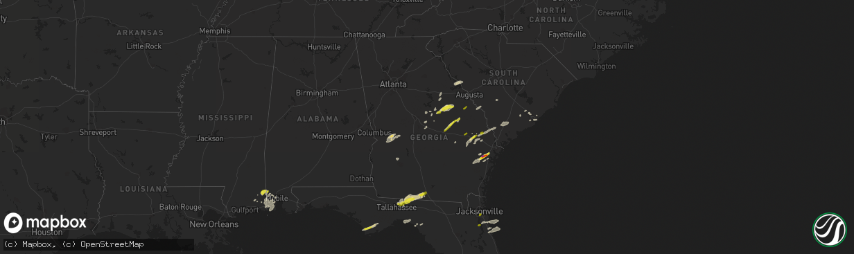
Hail
6,975
Estimated number of impacted properties by a 1.00" hail or larger1,127
Estimated number of impacted properties by a 1.75" hail or larger0
Estimated number of impacted properties by a 2.50" hail or largerStorm reports in Georgia
Georgia
| Date | Description |
|---|---|
| 04/03/20174:24 PM CDT | Reports of trees and power lines down |
| 04/03/20174:18 PM CDT | Reports of trees and power lines down |
| 04/03/20174:12 PM CDT | Reports of trees and power lines down |
| 04/03/20173:52 PM CDT | Social media picture showed a handful of quarter-sized hail stones. |
| 04/03/20173:42 PM CDT | Quarter size hail reported at rahns greenhouse off old dixie highway south |
| 04/03/20173:23 PM CDT | Screven county 911 reported a tree down near the intersection of oglethorpe trail and highway 301. |
| 04/03/20173:19 PM CDT | Screven county 911 reported a tree down near the intersection of plantation road and highway 301. |
| 04/03/20173:16 PM CDT | Screven county 911 reported a tree down near the intersection of buttermilk road and parker road. |
| 04/03/20173:09 PM CDT | Candler county dispatch reported a tree down in metter on washington street near bay street. |
| 04/03/20173:03 PM CDT | A spotter reported quarter size hail near richmond hill georgia. |
| 04/03/20173:03 PM CDT | A spotter reported 60 mph wind gusts with a passing thunderstorm. |
| 04/03/20173:01 PM CDT | The jenkins county warning point reported 4 trees down near perkins georgia. |
| 04/03/20172:52 PM CDT | Social media picture showed a handful of quarter-sized hail stones. |
| 04/03/20172:47 PM CDT | A trained spotter reports quarter sized hail currently falling on freedman grove road. |
| 04/03/20172:45 PM CDT | Roof damage reported at harvertys and a chinese restaurant along wrightsboro road. Also... Numerous reports of trees... Power lines and lights down in the area. . |
| 04/03/20172:43 PM CDT | Bulloch county 911 reported quarter sized hail near the intersection of highway 46 and sinkhole road. |
| 04/03/20172:43 PM CDT | Extensive damage to trees with a couple of homes damaged in the vicinity of belair road and powell road. . |
| 04/03/20172:38 PM CDT | Local media relayed a viewer report of hail the size of quartes or slightly larger near register. |
| 04/03/20172:35 PM CDT | Multiple trees down along advantage lane. |
| 04/03/20172:35 PM CDT | Tree and powerlines down. |
| 04/03/20172:32 PM CDT | Tree down at west church st. |
| 04/03/20172:31 PM CDT | A trained spotter relayed a picture of 2 hail stones ranging from 1 to 2 inches in diameter. The picture was from everson lane in midway. |
| 04/03/20172:30 PM CDT | Multiple trees down across county. |
| 04/03/20172:30 PM CDT | Multiple trees down across county. |
| 04/03/20172:30 PM CDT | *** 2 inj *** dock overturned and several boats damaged at points west marina. 2 injured were on the dock as it overturned. Injuries were minor. . |
| 04/03/20172:28 PM CDT | Several trees down along mckenzie drive. Time estimated from radar. |
| 04/03/20172:27 PM CDT | Several trees and powerlines down along west mooring road... Near swainsboro. Time estimated from radar. |
| 04/03/20172:25 PM CDT | Tree and powerlines down. |
| 04/03/20172:17 PM CDT | Multiple trees snapped off clarks mill road. Time estimated from radar. Possible tornado. |
| 04/03/20172:15 PM CDT | Reported more than 20 trees down along thomson highwy near the amity community and lake thurmond. Reported 6 to 8 trees snapped at 15 top 20 feet above the ground. Tree |
| 04/03/20172:09 PM CDT | A tree was reported on a car with one person trapped inside. Injuries unknown. Time estimated by radar. |
| 04/03/20172:04 PM CDT | Quarter size hail along meeks road southwest of kite. |
| 04/03/20172:00 PM CDT | This was an ef1 tornado with a path length of 7.84 miles and a maximum path width of approximately 1 mile. The estimated peak wind was 100 mph. The tornado caused minor |
| 04/03/20172:00 PM CDT | Several trees down at oconee church road and old toomsboro road. The oconee baptist church had damage to its roof as well as siding torn off. |
| 04/03/20172:00 PM CDT | Large tree limbs down over roads in fitzgerald |
| 04/03/20171:59 PM CDT | Trees down on ga-15 near dollar general and on the way motors |
| 04/03/20171:56 PM CDT | This was an ef1 tornado with a path length of .42 miles and a maxium path width of 179 yards. The estimated peak wind was 95 mph. This tornado uprooted and snapped nume |
| 04/03/20171:37 PM CDT | Multiple trees were reported down on highway 272 off of highway 24 west. |
| 04/03/20171:37 PM CDT | Power lines were reported down in the area of 117-140 j m walker road. |
| 04/03/20171:36 PM CDT | This was an ef1 tornado with a path length of 6.1 miles and a maximum path width of 688 yards. The estimated peak wind was 95 mph. This tornado caused roof damage to a |
| 04/03/20171:33 PM CDT | About a dozen trees down at residence off rocker road. Time estimated from radar. |
| 04/03/20171:30 PM CDT | Several trees down near the intersection of hwy 22 and 44. Time estimated by radar. |
| 04/03/20171:28 PM CDT | This was an ef1 tornado with a path length of .2 miles and a maximum path width of 250 yards. The estimated peak wind was 87 mph. This tornado caused damage to a single |
| 04/03/20171:25 PM CDT | Webeoc report of trees down blocking sr16 at green spring rd. Time estimated from radar. |
| 04/03/20171:21 PM CDT | This was an ef0 tornado with a path length of 3.2 miles and a maximum path width of 524 yards. The estimated peak wind was 80 mph. This tornado destroyed a small shed a |
| 04/03/20171:16 PM CDT | This was an ef0 tornado with a path length of 4.5 miles and a maximum path width of around .5 miles. The estimated peak wind was 84 mph. This tornado caused roof damage |
| 04/03/20171:15 PM CDT | Reports of numerous trees and powerlines down in turner county |
| 04/03/20171:15 PM CDT | Trees down on highway 33n |
| 04/03/20171:15 PM CDT | Trees down in the gordy area |
| 04/03/20171:14 PM CDT | Numerous trees were reported down near the intersections of bullard road and highway 80 and highway 96. |
| 04/03/20171:11 PM CDT | Severe structural damage was reported to the old chevrolet building in downtown gordon. |
| 04/03/20171:10 PM CDT | Video relayed by walb shows weak tornado over farmland near doles. No damage reported. |
| 04/03/20171:10 PM CDT | Trees down in the silver lake circle area |
| 04/03/20171:09 PM CDT | Numerous trees were reported down near the intersections of bullard rd and highway 96 and us 80. |
| 04/03/20171:09 PM CDT | Trees were reported down at highway 300 and the 300 connector. |
| 04/03/20171:08 PM CDT | Trees down along findley road |
| 04/03/20171:08 PM CDT | Trees down along old sr50 |
| 04/03/20171:06 PM CDT | Reports of power lines and trees down across worth county. Reports of trees down on homes. |
| 04/03/20171:06 PM CDT | Trees reported down near the highway 300/30 connector |
| 04/03/20171:05 PM CDT | Trees down in the woodcrest area |
| 04/03/20171:05 PM CDT | Trees down along mossy oaks road |
| 04/03/20171:03 PM CDT | This tornado was an ef2 with a path length of 3.3 miles and a maximum path width of 193 yards. The estimated peak wind was 115 mph. Several small business structures we |
| 04/03/20171:00 PM CDT | Tree down on highway 19 north of lewis collins road |
| 04/03/20171:00 PM CDT | Tree down on frazier road |
| 04/03/20171:00 PM CDT | Trees down on i16 eb on ramp at exit 18. Radar confirms tornado passed directly over the location. |
| 04/03/201712:57 PM CDT | A wind gust of 80 mph was reported near the turner park neighborhood on robbins afb. Also... Greater than 2 inch in diameter tree limbs/branches were reported down. |
| 04/03/201712:56 PM CDT | This tornado was an ef1 with a path length of 6. 3 miles and a maximum path width of 440 yards. The estimated peak wind was 93 mph. This tornado snapped and uprooted nu |
| 04/03/201712:55 PM CDT | Multiple trees were reported down near the intersection of highway 129 and mathis road. |
| 04/03/201712:52 PM CDT | Trees down in putney |
| 04/03/201712:51 PM CDT | A tree was reported down near the intersection of fawn court and buck road. |
| 04/03/201712:50 PM CDT | A large tree limb was reported on a houes near 13 green street. |
| 04/03/201712:48 PM CDT | Boat flipped at marine dealer on radium springs road. |
| 04/03/201712:47 PM CDT | Lite structure damage was reported near the intersection of highway 41 and dunbar road... Near the houston and peach county line. |
| 04/03/201712:45 PM CDT | Social media report of a home with really bad damage near the middle ga regional airport |
| 04/03/201712:44 PM CDT | A tree was reported down on macy ave near highway 127. |
| 04/03/201712:42 PM CDT | Power pole down on car on north harding st. |
| 04/03/201712:42 PM CDT | Tree down on 12th avenue |
| 04/03/201712:42 PM CDT | Trees were reported down on scarsborough road as well as near the intersection of dunbar road and carl vinson parkway. A tree was also reported down on an apartment uni |
| 04/03/201712:42 PM CDT | Tree down on house off of stuart |
| 04/03/201712:42 PM CDT | Tree down on a house on doncaster drive |
| 04/03/201712:42 PM CDT | Wind damage to roof of building off of temple avenue |
| 04/03/201712:42 PM CDT | A tree was reported down near the intersection of highway 11 and round oak juliette road. |
| 04/03/201712:42 PM CDT | Tree down at 1206 whispering pines road |
| 04/03/201712:42 PM CDT | Shed flipped over in albany |
| 04/03/201712:40 PM CDT | This was an ef0 tornado with a path length of 3 miles and a maximum path width of 100 yards. The estimated peak wind was 70 mph. This tornado uprooted a tree that cause |
| 04/03/201712:36 PM CDT | Reports of trees and power lines down in baconton |
| 04/03/201712:36 PM CDT | A tree was reported on a home near 341 surrey place. Other trees were also reported down nearby. |
| 04/03/201712:35 PM CDT | Two large pines down. |
| 04/03/201712:22 PM CDT | Multiple trees and power lines were reported down along taylors mill road. |
| 04/03/201712:21 PM CDT | Heavy damage occured to hays tractor and equipment inc. Power lines were also reported down at the car lot and at city hall. |
| 04/03/201712:19 PM CDT | Power lines and a tree was reported down near 410 north randolph street. |
| 04/03/201712:17 PM CDT | Tree down on a house reported on mallon road |
| 04/03/201712:16 PM CDT | As many as 30 homes with damage in monroe county..9 major and 1 destroyed. 1 family was trapped but no injuries were reported |
| 04/03/201712:14 PM CDT | Tree down in the roadway at the intersection of hwy 153 and hwy 30 |
| 04/03/201712:14 PM CDT | Multiple trees were reported down along highway 213 between the intersections of dixie road and hayston road. |
| 04/03/201712:12 PM CDT | Reports of trees and power lines down across county...also report of metal shed blown into highway near colquitt. |
| 04/03/201712:12 PM CDT | Trees fell on cars along i-75 south of forsyth. Injuries reported but number is currently unknown |
| 04/03/201712:12 PM CDT | Trees reported down on home near music row. |
| 04/03/201712:12 PM CDT | Reports of several trees and power lines down in baker county |
| 04/03/201712:11 PM CDT | A large tree was reported across highway 341 north at the crawford county and monroe county line. |
| 04/03/201712:08 PM CDT | Significant damage reported in a two block path in gordon |
| 04/03/201712:06 PM CDT | This was a high end ef1 tornado with a path length of 8.3 miles and a maximum path width of 300 yards. The estimated peak wind was 110 mph. This tornado damaged 30 home |
| 04/03/201712:00 PM CDT | Highway 74 east of culloden... Several pieces of a tin roof folded back. Damage to the sliding door of a garage shop. |
| 04/03/201711:56 AM CDT | Trees were reported down near the intersection of willis road and highway 341. |
| 04/03/201711:54 AM CDT | Reports of trees down near blakely |
| 04/03/201711:54 AM CDT | Trees reported down on homes on norwood street and college street |
| 04/03/201711:53 AM CDT | *** 1 inj *** a tree was reported down on a house near 355 pine circle. Additional tree damage was reported along ebenezer road. |
| 04/03/201711:53 AM CDT | In ellaville... Around 150 trees were reported down... Multiple trees were reported down on homes... Multiple structural collapses occurred... And two tractor-trailers |
| 04/03/201711:52 AM CDT | This was an ef0 tornado with a path length of 1.8 miles with a maximum path width of 250 yards. The estimated peak wind was 85 mph. This tornado caused minor shingle da |
| 04/03/201711:51 AM CDT | Multiple trees down along pleasant grove road south of yatesville |
| 04/03/201711:51 AM CDT | Trees snapped and uprooted. |
| 04/03/201711:49 AM CDT | Several trees reported down along the rock road |
| 04/03/201711:49 AM CDT | Em reports 40-50 trees down and minor structural damage to homes between bonaventure place and jaley pkwy. Time estimated from radar. |
| 04/03/201711:49 AM CDT | Gdot reporting metal debris and trees across hwy 153 at mile marker 7.5 southwest of ellaville. |
| 04/03/201711:46 AM CDT | There were reports of wires down at 3099 east fairview road. |
| 04/03/201711:46 AM CDT | This was an ef1 tornado with a path length of 5.6 miles and a maximum path width of 200 yards. The estimated peak wind was 105 mph. This tornado caused damage to over 4 |
| 04/03/201711:44 AM CDT | This was an ef1 tornado that had a path length of 6.9 miles and a maximum path width of 150 yards. The estimated peak wind was 90 mph. This tornado caused minor damage |
| 04/03/201711:40 AM CDT | A homeowner reported trees down and damage to the home near 3278 waymanville road... With approximated wind speeds between 50-60 mph. |
| 04/03/201711:36 AM CDT | This was an ef0 tornado with a path length of 1.7 miles and a maximum path width of 75 yards. The estimated peak wind was 70 mph. This tornado snapped numerous trees an |
| 04/03/201711:36 AM CDT | Multiple trees were down near the crossing of pobiddy road and the flint river. |
| 04/03/201711:35 AM CDT | This was an ef0 tornado with a path length of .6 miles and a maximum path width of 150 yards. The estimated peak wind speed was 85 mph. The tornado snapped and uprooted |
| 04/03/201711:32 AM CDT | Numerous trees were reported down and also on structures near 600 block of melrose ave. Multiple trees were also reported down near the intersections of hillwood ave an |
| 04/03/201711:32 AM CDT | Trees and power lines were reported down near 133 south 17 street. |
| 04/03/201711:32 AM CDT | Trees were reported down near the intersection of kennedy road and n 2nd street. |
| 04/03/201711:32 AM CDT | Numerous trees were reported down along charlie thomas road. |
| 04/03/201711:32 AM CDT | Trees were reported down on a house near 1109 east wall street. |
| 04/03/201711:32 AM CDT | Power lines were reported down and a tree fell blocking the entire road near 417 east college street. |
| 04/03/201711:32 AM CDT | A tree was reported down on a house with a person rescued from house. Injuries unknown. |
| 04/03/201711:32 AM CDT | A trees were reported down on a house with a person trapped inside near 546 north 9th street. Injuries unknown. |
| 04/03/201711:30 AM CDT | Multiple trees and powerlines down... Several houses damaged with people trapped insude near intersection of popular street and 13th street in griffin |
| 04/03/201711:30 AM CDT | Multiple trees and power lines down and person trapped in vehicle on west ellis road |
| 04/03/201711:27 AM CDT | Two trees were reported down near the intersection of town creek road and highway 115. |
| 04/03/201711:26 AM CDT | This was an ef1 tornado with a path length of 4.6 miles and a maximum path width of 200 yards. The estimated peak wind was 105 mph. This tornado snapped and uprooted nu |
| 04/03/201711:25 AM CDT | Trees and powerlines were reported down near the intersection of patton rd and sunset strip. Barn roof metal wrapped around trees were also reported. |
| 04/03/201711:25 AM CDT | Multiple trees and powerlines reported down near intersection of popular street and 13th street in griffin |
| 04/03/201711:23 AM CDT | Multiple structures with damage and partial building collapse reported near the intersection of county road 213 and 11 |
| 04/03/201711:21 AM CDT | Two trees and a power pole reported down along highway 520 in richland |
| 04/03/201711:20 AM CDT | Trees down across powerlines. Causing shut down of eastbound lane of sr 520. |
| 04/03/201711:18 AM CDT | This was an ef0 tornado with a path length of 2.2 miles and a maximum path width of 75 yards. The estimated peak wind was 70 mph. This tornado snapped numerous trees an |
| 04/03/201711:18 AM CDT | This was an ef1 tornado with a path length of 4.63 miles and a maximum path width of 373 yards. The estimated peak wind was 100 mph. This tornado caused significant dam |
| 04/03/201711:16 AM CDT | This was an ef0 tornado with a path length of 3.9 miles and a maxium path width of 150 yards. The estimated peak wind speed was 75 mph. This tornado snapped and uproote |
| 04/03/201711:16 AM CDT | This was an ef0 tornado that had a path length of 1.3 miles and a maximum path width of 100 yards. The estimated peak wind was 70 mph. This tornado damaged an outbuildi |
| 04/03/201711:13 AM CDT | Tree reported down at intersection of rockwell street and hardwick lane. |
| 04/03/201711:10 AM CDT | Several trees down and shingle damage on home on old chestnut road |
| 04/03/201711:10 AM CDT | This was an ef0 tornado with a path length of 1.6 miles and a maximum path width of 150 yards. The estimated peak wind was 85 mph. This tornado snapped and downed numer |
| 04/03/201711:08 AM CDT | Power lines down on truck. Trees down highway 39 and 82. |
| 04/03/201711:00 AM CDT | Reports of trees and power lines down countywide |
| 04/03/201710:58 AM CDT | A large oak tree was reported down across power lines at the intersection of robin road and st. Marys road. |
| 04/03/201710:54 AM CDT | Several trees were reported down near the 8000 block of fulton road. A power line was also down in the road on county line road. |
| 04/03/201710:44 AM CDT | 2 trees down on homes |
| 04/03/201710:42 AM CDT | This was an ef0 tornado with a path length of 3.5 miles with a maximum path width of 175 yards. The maximum estimated peak wind was 90 mph. This tornado uprooted and sn |
| 04/03/201710:42 AM CDT | A tree was reported down on a house blocking the road near the intersection of bob-o-link drive and robin road. |
| 04/03/201710:42 AM CDT | A tree was reported down on a house on kingfisher road. |
| 04/03/201710:40 AM CDT | An 8 inch diameter tree was reported down at the intersection of veterans memorial highway sw and south gordon road sw... With a traffic light hanging into the road. |
| 04/03/201710:36 AM CDT | The tornado initially touched down on campbellton redwine road about .20 miles north of south fulton parkway. It then touched down intermittently eastward about 3.8 mil |
| 04/03/201710:32 AM CDT | A couple dozen trees were reported down along mullinax road off of highway 53. |
| 04/03/201710:32 AM CDT | A shed was picked up near the intersection of hill city road and mullinax road... Where the roof was ripped off. The shed was then blown across highway 53 and was destr |
| 04/03/201710:30 AM CDT | Trees down in downtown sparta |
| 04/03/201710:30 AM CDT | Trees down at upper big springs rd and knot rd |
| 04/03/201710:25 AM CDT | Trees down at hunts chapel rd and hwy 16 west |
| 04/03/201710:23 AM CDT | Tree reported down at the intersection of reinhardt college parkway and salacoa road |
| 04/03/201710:10 AM CDT | The carrollton city firestation number 22 suffered structural damage to the building. |
| 04/03/201710:10 AM CDT | Multiple trees were reported down at the intersection of cedar street and hwy 166. |
| 04/03/201710:00 AM CDT | Tree down on house on e 7th street in west point |
| 04/03/20179:59 AM CDT | Tree reported down along alabama street in carrollton |
| 04/03/20179:58 AM CDT | This was an ef1 tornado that had a path length of 2.5 miles with a maxium path width of 300 yards. The estimated peak wind was 90 mph. This tornado snapped and uprooted |
All States Impacted by Hail Map on April 3, 2017
Cities Impacted by Hail Map on April 3, 2017
- Buena Vista, GA
- Ellaville, GA
- Rupert, GA
- Mauk, GA
- Lucedale, MS
- Boston, GA
- Quitman, GA
- Dixie, GA
- Monticello, FL
- Valdosta, GA
- Perry, FL
- Arnett, OK
- Vici, OK
- Leedey, OK
- Camargo, OK
- Scott City, MO
- Thebes, IL
- Chaffee, MO
- McClure, IL
- Reydon, OK
- Midway, GA
- Fleming, GA
- Tamms, IL
- Ponte Vedra Beach, FL
- Sparta, GA
- Stratford, TX
- Mobile, AL
- Adrian, GA
- Kite, GA
- Canadian, TX
- Briscoe, TX
- Riceboro, GA
- Vidalia, GA
- Statesboro, GA
- Claxton, GA
- Register, GA
- Arapaho, OK
- Port Saint Joe, FL
- Wewahitchka, FL
- Eastpoint, FL
- Collins, GA
- Reidsville, GA
- Wilmer, AL
- Warthen, GA
- Semmes, AL
- Plum Branch, SC
- Lincolnton, GA
- Brooklet, GA
- Pembroke, GA
- Ellabell, GA
- Saint Augustine, FL
- Theodore, AL
- Grand Bay, AL
- Irvington, AL
- Moss Point, MS
- Bayou La Batre, AL
- Coden, AL
- Summerville, SC
- Jeffersonville, GA
- Ludowici, GA
- Mount Pleasant, SC
- Avera, GA
- Gibson, GA
- Davisboro, GA
- Louisville, GA
- Durham, OK
- Cheyenne, OK
- Girard, GA
- Tallahassee, FL
- Greenville, FL
- Thomasville, GA
- New Athens, IL
- Allenhurst, GA
- Hammon, OK
- Swainsboro, GA
- Wrightsville, GA
- East Dublin, GA
- Danville, GA
- Modoc, SC
- Stapleton, GA
- Sandersville, GA
- Mitchell, GA
- Midville, GA
- Yemassee, SC
- Early Branch, SC
- Hardin, KY
- Richmond Hill, GA
- Leesburg, GA
- Benton, KY
- Bamberg, SC
- Denmark, SC
- Preston, GA
- Oglethorpe, GA
- Ideal, GA
- Hazlehurst, GA
- Fort Stewart, GA
- Butler, OK
- Hinesville, GA
- Gruver, TX
- Springfield, GA
- Toomsboro, GA
- McIntyre, GA
- Braithwaite, LA
- Buras, LA
- Milledgeville, GA
- Ridgeville, SC
- Adams Run, SC
- Ladson, SC
- North Charleston, SC
- Goose Creek, SC
- Charleston, SC
- Hanahan, SC
- Vancleave, MS
- Martin, SC
- Haddock, GA
- Gordon, GA
- Pineland, SC
- Guyton, GA
- Garnett, SC
- Clyo, GA
- Tillman, SC
- Jesup, GA
- Johns Island, SC
- Cochran, GA
- Lamont, FL
- Perryton, TX
- Spearman, TX
- Crawfordville, GA
- Biloxi, MS
- Eight Mile, AL
- Rockledge, GA
- Wadley, GA
- Waynesboro, GA
- Keysville, GA
- Metter, GA
- Gilbertsville, KY
- Jacksonville, FL
- Green Cove Springs, FL