Hail Map in Texas on April 18, 2026
The weather event in Texas on April 18, 2026 includes Hail map. 1 state and 84 cities were impacted and suffered possible damage. The total estimated number of properties impacted is 52,247.
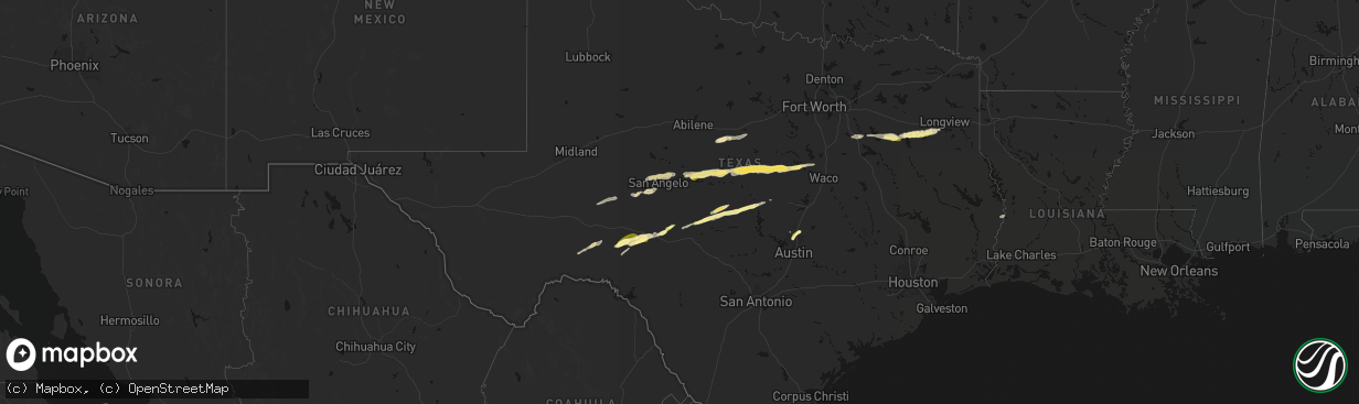
Hail
52,247
Estimated number of impacted properties by a 1.00" hail or larger0
Estimated number of impacted properties by a 1.75" hail or larger0
Estimated number of impacted properties by a 2.50" hail or largerStorm reports in Texas
Texas
| Date | Description |
|---|---|
| 04/18/202611:13 AM CDT | Tree downed on cr 2813 southwest of tatum. |
| 04/18/202610:47 AM CDT | A large tree was uprooted on powerlines near the intersection of florence street and camp street in the city of kilgore... Causing a power outage. |
| 04/18/202610:30 AM CDT | A few social media reports of hail nearly covering the ground around lake tyler. Hail range from pea to quarter size. |
| 04/18/202610:28 AM CDT | Hail estimated up to 1 inch in downtown whitehouse. |
| 04/18/202610:25 AM CDT | Tree uprooted behind the lowes on the south side of tyler. Time estimated from radar. |
| 04/18/202610:23 AM CDT | Numerous reports of hail nearly covering the ground across a large portion of south tyler. Hail ranged from pea size to quarter size. |
| 04/18/202610:21 AM CDT | Hail covering the ground from pea size to quarter size in the gresham area... Just south of tyler. |
| 04/18/202610:20 AM CDT | Corrects previous tstm wnd dmg report from 4 ne noonday. Media reports of wind snapping several large branches of trees at a business near the intersection of state hig |
| 04/18/202610:15 AM CDT | Facebook photos show hail up to quarter size 3 miles south of clifton. |
| 04/18/20269:54 AM CDT | Facebook report of penny to quarter size hail in athens along with torrential rain. |
| 04/18/20268:09 AM CDT | Nickel to quarter size hail reported at lake ivie. |
| 04/17/202610:20 PM CDT | Media reports of wind snapping several large branches of trees at a business near the intersection of state highway 155 and west grande boulevard. This caused minor dam |
| 04/17/20268:02 PM CDT | Numerous reports of pea to quarter size hail across a swath between georgetown and round rock including communities near westinghouse rd... Fm 1460... And sh 130. Time |
| 04/17/20267:47 PM CDT | Hail photo with received with ruler. Time estimated via radar. |
All States Impacted by Hail Map on April 18, 2026
Cities Impacted by Hail Map on April 18, 2026
- Cisco, TX
- Rising Star, TX
- San Angelo, TX
- Cross Plains, TX
- Big Lake, TX
- Carbon, TX
- Gorman, TX
- Miles, TX
- Paint Rock, TX
- Ballinger, TX
- Millersview, TX
- Voss, TX
- Rowena, TX
- Barnhart, TX
- Mertzon, TX
- Coleman, TX
- Bangs, TX
- Gouldbusk, TX
- Santa Anna, TX
- Brookesmith, TX
- Valera, TX
- Brownwood, TX
- Early, TX
- Mullin, TX
- Comanche, TX
- Zephyr, TX
- Hamilton, TX
- Priddy, TX
- Gustine, TX
- Goldthwaite, TX
- Pottsville, TX
- Chatfield, TX
- Rice, TX
- Kemp, TX
- Ennis, TX
- Jonesboro, TX
- Hico, TX
- Athens, TX
- Malakoff, TX
- Trinidad, TX
- Eustace, TX
- Mabank, TX
- Clifton, TX
- Gatesville, TX
- Valley Mills, TX
- Murchison, TX
- Brownsboro, TX
- Larue, TX
- Chandler, TX
- Tyler, TX
- Flint, TX
- Whitehouse, TX
- Arp, TX
- Dryden, TX
- China Spring, TX
- Ozona, TX
- Kilgore, TX
- Overton, TX
- Henderson, TX
- Longview, TX
- Del Rio, TX
- Sonora, TX
- Eldorado, TX
- Junction, TX
- Menard, TX
- Mason, TX
- Hext, TX
- Fredonia, TX
- San Saba, TX
- Pontotoc, TX
- Voca, TX
- Cherokee, TX
- Lampasas, TX
- Lometa, TX
- Brady, TX
- Newton, TX
- Burkeville, TX
- Valley Spring, TX
- New Braunfels, TX
- Austin, TX
- Round Rock, TX
- Cedar Park, TX
- Georgetown, TX
- Hutto, TX


