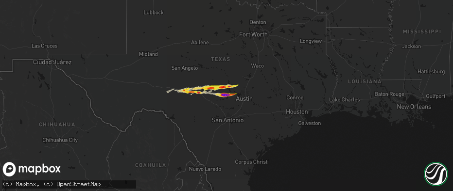
Hail Map on May 6, 2026
The weather event on May 6, 2026 includes Hail, Wind, and Tornado maps. 6 states and 244 cities were impacted and suffered possible damage. The total estimated number of properties impacted is 53,471.
Hail
Wind
Tornado
53,471
Estimated number of impacted properties by a 1.00" hail or larger23,407
Estimated number of impacted properties by a 1.75" hail or larger10,298
Estimated number of impacted properties by a 2.50" hail or largerStorm reports
Mississippi
| Date | Description |
|---|---|
| 05/06/20266:55 PM CDT | Confirmed tornado - a tds was observed on the 88d radar network. |
| 05/06/20266:45 PM CDT | A local report indicates 1.75 inch wind near 2 N Clem |
| 05/06/20266:41 PM CDT | Confirmed tornado - a tds was observed on the 88d radar network. |
| 05/06/20266:23 PM CDT | Law enforcement reported multiple trees down across lawrence county. |
| 05/06/20266:10 PM CDT | A local report indicates 1.75 inch wind near 1 SSE De Kalb |
| 05/06/20266:10 PM CDT | Numerous trees were snapped and uprooted and blocking roads. This damage report and related photos were relayed through social media. |
| 05/06/20266:00 PM CDT | Photo of tree down across highway 27 south of lexie. Possible tornado damage. |
| 05/06/20266:00 PM CDT | Video showed several trees downed near stallings bridge road. Possible tornado damage. |
| 05/06/20266:00 PM CDT | 2 to 2.75 hail at hwy 16 and 493. Trees also down in the area. |
| 05/06/20265:54 PM CDT | A local report indicates 1.25 inch wind near 2 NW Tylertown |
| 05/06/20265:54 PM CDT | A local report indicates 1.50 inch wind near 1 NNE Tylertown |
| 05/06/20265:51 PM CDT | Emergency manager reported trees down on hwy 25 and pea size hail. |
| 05/06/20265:51 PM CDT | Emergency manager reported golf to baseball size hail near rd 452. |
| 05/06/20265:45 PM CDT | Several trees were snapped and uprooted in the bloomo community. This was relayed through social media. |
| 05/06/20265:45 PM CDT | Pictures of damage to steel awning on county road 505 were relayed. |
| 05/06/20265:40 PM CDT | Numerous trees were snapped and uprooted and blocking roads in the williamsville community. This damage report and related photos were relayed through social media. |
| 05/06/20265:39 PM CDT | Emergency manager reported golf ball size hail at hwy 21 s and hwy 488. |
| 05/06/20265:35 PM CDT | A picture on social media showed golf ball sized hail in osyka. |
| 05/06/20265:02 PM CDT | Trees down on lines in e madison. |
| 05/06/20265:00 PM CDT | This was reported by a nearby convenience store... And video was taken of the hail as well. |
| 05/05/202611:23 PM CDT | Marion county ema reports that trees were down and a house destroyed on ridgewood drive. |
| 05/05/20269:15 PM CDT | A concentrated area of tree and power line damage occurred along wilson road. One tree fell onto a home. |
| 05/05/20269:10 PM CDT | A concentrated area of tree and power line damage occurred along salem church road. |
| 05/05/20268:58 PM CDT | Storm chaser reported power flashes and flying debris at ms hwy 42 near fate ward rd. |
| 05/05/20268:26 PM CDT | Confirmed tornado - a tds was observed on the 88d radar network. |
| 05/05/20268:14 PM CDT | Confirmed tornado - a tds was observed on the 88d radar network. |
| 05/05/20268:03 PM CDT | Confirmed tornado - a tds was observed on the 88d radar network. |
| 05/05/20267:57 PM CDT | Confirmed tornado - a tds was observed on the 88d radar network. |
| 05/05/20267:49 PM CDT | Confirmed tornado - a tds was observed on the 88d radar network. |
| 05/05/20267:37 PM CDT | Confirmed tornado - a tds was observed on the 88d radar network. |
| 05/05/20267:26 PM CDT | Emergency manager reported damage to office building. |
| 05/05/20267:12 PM CDT | Confirmed tornado - a tds was observed on the 88d radar network. |
| 05/05/20267:10 PM CDT | Confirmed tornado - a tds was observed on the 88d radar network. |
| 05/05/20267:07 PM CDT | Corrects time of previous tornado report from 2 n purvis and updated damage info. Major damage occurred to buildings along ms highway 589 and old highway 11. An office |
| 05/05/20267:02 PM CDT | Confirmed tornado - a tds was observed on the 88d radar network. |
Alabama
| Date | Description |
|---|---|
| 05/06/20266:52 PM CDT | Broadcast media relayed viewer video of ping pong ball sized hail near boligee. |
| 05/06/20265:45 PM CDT | Hail of at least quarter sized observed by broadcast meteorologist just north of cr 2 in macon county. |
| 05/06/20265:45 PM CDT | Quarter sized hail reported by the public in fort davis around 5:45 pm. Time and location approximate. |
| 05/06/20265:33 PM CDT | Location approximate. |
| 05/06/20265:18 PM CDT | Baseball sized hail reported along interstate 85 at exit 10 reported by trained spotter. Time approximate. |
| 05/06/20265:12 PM CDT | Quarter sized hail reported by the public at mellow mushroom. Time approximate. |
| 05/06/20265:07 PM CDT | Public reported a portion of a tree fell on a car near pike road close to u.s. 231. Time and location approximate. |
| 05/06/20265:05 PM CDT | Report and photo of trees down... Some impacting power lines near trotman road west of pike road. |
| 05/06/20265:04 PM CDT | Report of trees down along snowdoun chambers road southeast of montgomery. Time and location approximate. |
| 05/06/20265:03 PM CDT | Report of tennis ball size hail reported along taylor road near eastchase mall. Time approximate. |
| 05/06/20265:02 PM CDT | Mgm 062202z 35014g50kt 1/2sm +tsra fg bkn018 bkn034 ovc044 22/21 a2991 rmk ao2 pk wnd 33050/2155 wshft 2146 ltg dsnt n-se p0059 t02170211. |
| 05/06/20264:59 PM CDT | Tree down along west wareingwood drive in montgomery. Time approximate. |
| 05/06/20264:55 PM CDT | Corrected to show peak gust time of 2155z. Mgm 062202z 35014g50kt 1/2sm +tsra fg bkn018 bkn034 ovc044 22/21 a2991 rmk ao2 pk wnd 33050/2155 wshft 2146 ltg dsnt n-se p00 |
| 05/06/20264:53 PM CDT | Tree reported down across 180 west blvd west of montgomery. Time approxmiate. |
| 05/06/20264:51 PM CDT | Montgomery county ema reports 3303 power outages... 7 trees down... 4 power lines down and 5 traffic lights out. Time and location approximate. |
| 05/06/20262:30 PM CDT | Trees down across highway 69 south of gallion. |
| 05/06/20266:12 AM CDT | Report of a tree down near cr 113 and cr72. |
| 05/05/20268:30 PM CDT | Numerous trees down in the belmont area. Time estimated by radar. |
| 05/05/20267:33 PM CDT | Hale county ema reports many without power in southern hale county... Many trees down and some power poles snapped. Hail up to golf ball size reported west of newbern. |
| 05/05/20267:31 PM CDT | At least ping pong ball size hail reported near the lock five community. |
| 05/05/20267:28 PM CDT | Corrects previous tstm wnd dmg report from 3 ne arcola. Report of trees down with large hail in the lock five community. Photo of a camper on its side submitted by the |
| 05/05/20267:28 PM CDT | Report of trees down with large hail in the lock five community. Time and location approximate. |
| 05/05/20267:13 PM CDT | Photo submitted by the public of baseball sized hail along u.s. Highway 43 in greene county. Time and location approximate. |
| 05/05/20267:11 PM CDT | Broadcast media relayed viewer report of at least golf ball hail covering the ground... Backyard garden destroyed. |
| 05/05/20267:11 PM CDT | Public submitted photo of ping pong ball sized hail in forkland. |
| 05/05/20267:10 PM CDT | Report of ping pong ball sized hail at forkland campground. |
Tennessee
| Date | Description |
|---|---|
| 05/06/20267:09 AM CDT | Emergency manager reported a tree down on decherd estill road. Time estimated by radar. |
| 05/06/20267:08 AM CDT | Emergency management reported a tree down on mansford road. Time estimated by radar. |
Georgia
| Date | Description |
|---|---|
| 05/05/20269:48 PM CDT | Corrects previous non-tstm wnd dmg report from 3 w draneville. Major damage to a barn near the intersection of slaughter rd and ga hwy 41. |
| 05/05/20267:22 PM CDT | Tree down across roadway near intersection of bean creek rd and gold valley rd. |
| 05/05/20267:20 PM CDT | Tree down along skitts mountain road near campground rd blocking 1 lane. |
Texas
| Date | Description |
|---|---|
| 05/06/202610:33 AM CDT | Video of hen egg size hail from round mountain-sandy road. |
| 05/06/202610:18 AM CDT | Report from mping. |
| 05/06/202610:16 AM CDT | Baseball size hail near the intersection of althaus davis road/althaus acres road. |
| 05/06/202610:15 AM CDT | Cocorahs observer reports 1.75 to 2.00 inch diameter hail. |
| 05/06/202610:14 AM CDT | Quarter size hail near the intersection of pressler road and fm 1323. |
| 05/06/202610:05 AM CDT | Facebook photo of baseball size hail near bell mountain winery. |
| 05/06/202610:03 AM CDT | A local report indicates 2.75 inch wind near 2 WNW Willow City |
| 05/06/202610:00 AM CDT | Up to ping pong size. Time estimated via radar. |
| 05/06/20269:56 AM CDT | Hen egg size hail on cr 119 south of llano. |
| 05/06/20269:48 AM CDT | A local report indicates 1.00 inch wind near 2 W Burnet |
| 05/06/20269:44 AM CDT | Report from mping. |
| 05/06/20269:40 AM CDT | A local report indicates 1.50 inch wind near Inks Lake State Park |
| 05/06/20269:40 AM CDT | Golfball size hail reported on west side of sh 29 bridge. |
| 05/06/20269:35 AM CDT | Hen egg size hail reported at buchanan dam. |
| 05/06/20269:34 AM CDT | Corrects previous hail report from 1 s llano. Hen egg size hail on cr 119 south of llano. |
| 05/06/20269:30 AM CDT | At the intersection of fm 2323 and cr117 near llano. |
| 05/06/20269:22 AM CDT | Falling at cr 117 in llano county. |
| 05/06/20269:14 AM CDT | Report from mping. |
| 05/06/20268:48 AM CDT | Report from mping: quarter |
| 05/06/20268:45 AM CDT | A local report indicates 2.50 inch wind near Junction |
| 05/06/20268:45 AM CDT | A local report indicates 1.00 inch wind near 7 E Mason |
| 05/06/20268:44 AM CDT | A local report indicates 1.25 inch wind near 3 SW Junction |
| 05/06/20268:40 AM CDT | A local report indicates 1.75 inch wind near 7 NNW Loyal Valley |
| 05/06/20268:30 AM CDT | A local report indicates 1.75 inch wind near 9 S Streeter |
Cities Impacted by Hail Map on May 6, 2026
- Sonora, TX
- Ozona, TX
- Junction, TX
- Menard, TX
- London, TX
- Roosevelt, TX
- Mason, TX
- Art, TX
- Castell, TX
- Llano, TX
- Buchanan Dam, TX
- Doss, TX
- Harper, TX
- Burnet, TX
- Kingsland, TX
- Fredericksburg, TX
- Bluffton, TX
- Willow City, TX
- Bertram, TX
- Round Mountain, TX
- Johnson City, TX
- Spicewood, TX
- Ward, AL
- York, AL
- Jachin, AL
- Demopolis, AL
- Deville, LA
- Linden, AL
- Gallion, AL
- Faunsdale, AL
- Thomaston, AL
- Uniontown, AL
- Safford, AL
- Jonesville, LA
- Monterey, LA
- Vidalia, LA
- Selma, AL
- Tyler, AL
- Natchez, MS
- Double Springs, AL
- Prattville, AL
- Addison, AL
- Houston, AL
- Autaugaville, AL
- Canton, MS
- Lowndesboro, AL
- Hope Hull, AL
- Montgomery, AL
- Meadville, MS
- Camden, MS
- Logan, AL
- Arley, AL
- Cullman, AL
- Vinemont, AL
- Bentonia, MS
- Bude, MS
- Carthage, MS
- Pike Road, AL
- Lena, MS
- Walnut Grove, MS
- McCall Creek, MS
- Brookhaven, MS
- Kentwood, LA
- Greensburg, LA
- Shorter, AL
- Union, MS
- Philadelphia, MS
- Hardaway, AL
- Cecil, AL
- Fitzpatrick, AL
- Jena, LA
- Effie, LA
- Magnolia, MS
- Osyka, MS
- Harrisonburg, LA
- Center Point, LA
- Tuskegee, AL
- Mccomb, MS
- Mathews, AL
- Union Springs, AL
- Clayton, LA
- Tylertown, MS
- Collinsville, MS
- De Kalb, MS
- Hurtsboro, AL
- Midway, AL
- Marksville, LA
- Thomasville, AL
- Fort Davis, AL
- Summit, MS
- Jayess, MS
- Hazlehurst, MS
- Crystal Springs, MS
- Ellijay, GA
- Vicksburg, MS
- Monticello, MS
- Porterville, MS
- Scooba, MS
- Foxworth, MS
- Columbia, MS
- Oak Vale, MS
- Silver Creek, MS
- Florence, MS
- Prentiss, MS
- Kokomo, MS
- Crosby, MS
- Epes, AL
- Emelle, AL
- Newhebron, MS
- Carson, MS
- Harrisville, MS
- Downsville, LA
- Sandy Hook, MS
- Roxie, MS
- Talking Rock, GA
- Acme, LA
- Woodville, MS
- Gloster, MS
- Sumrall, MS
- Helen, GA
- Sautee Nacoochee, GA
- Mize, MS
- Magee, MS
- Mount Olive, MS
- Livingston, AL
- Boligee, AL
- Wetumpka, AL
- Collins, MS
- Gainesville, AL
- Braxton, MS
- Farmerville, LA
- Sterlington, LA
- Lumberton, MS
- Columbia, LA
- Purvis, MS
- Hattiesburg, MS
- Forkland, AL
- Eclectic, AL
- Millbrook, AL
- New Augusta, MS
- Petal, MS
- Richton, MS
- Greensboro, AL
- Newbern, AL
- Hineston, LA
- Tallassee, AL
- Elmer, LA
- Sawyerville, AL
- Bogue Chitto, MS
- Beaumont, MS
- Lauderdale, MS
- Toomsuba, MS
- Mangham, LA
- Marion, AL
- Smithdale, MS
- Cuba, AL
- Leakesville, MS
- Neely, MS
- Noxapater, MS
- Pineville, LA
- Kosciusko, MS
- State Line, MS
- McCool, MS
- Louisville, MS
- Tuskegee Institute, AL
- Ruth, MS
- Little Rock, MS
- Redwood, MS
- Alexander City, AL
- Kellyton, AL
- Sontag, MS
- Goodwater, AL
- McLain, MS
- Bellamy, AL
- Vinegar Bend, AL
- Fruitdale, AL
- Hatchechubbee, AL
- Daleville, MS
- Tibbie, AL
- Deer Park, AL
- McIntosh, AL
- Seale, AL
- Pittsview, AL
- Tallulah, LA
- Sunflower, AL
- Fort Mitchell, AL
- Wagarville, AL
- Seminary, MS
- Cusseta, GA
- Omaha, GA
- Edwards, MS
- Richland, GA
- Jackson, AL
- Lumpkin, GA
- Americus, GA
- Buena Vista, GA
- Preston, GA
- Ellaville, GA
- Laurel, MS
- Shubuta, MS
- Evergreen, AL
- Repton, AL
- Bailey, MS
- Meridian, MS
- Waynesboro, MS
- Plains, GA
- Soso, MS
- Preston, MS
- Taylorsville, MS
- Brantley, AL
- Rutledge, AL
- Luverne, AL
- Greenville, AL
- Bassfield, MS
- Heidelberg, MS
- Louin, MS
- Bay Springs, MS
- Rose Hill, MS
- Citronelle, AL
- Little River, AL
- Uriah, AL
- Mount Vernon, AL
- Stockton, AL
- Lisman, AL
- Atmore, AL
- Brewton, AL
- Marion Junction, AL
- Castleberry, AL
- Woodland, MS
- Houston, MS
- Daviston, AL
- Brooklyn, MS
- Dozier, AL
- Frisco City, AL
- Glenwood, AL
- Monroeville, AL
- Lenox, AL
- Range, AL
- Ariton, AL
- Brundidge, AL
- Bay Minette, AL
- Perdido, AL
- McDavid, FL
- Andalusia, AL