Hail Map in Montgomery, AL on May 6, 2026
The weather event in Montgomery, AL on May 6, 2026 includes Hail, Wind, and Tornado maps. 6 states and 244 cities were impacted and suffered possible damage. The total estimated number of properties impacted is 9,080.
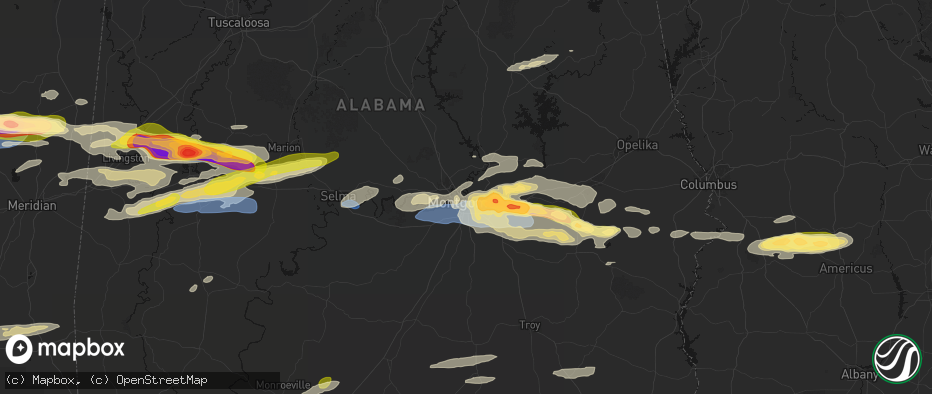
Hail
Wind
Tornado
9,080
Estimated number of impacted properties by a 1.00" hail or larger5,183
Estimated number of impacted properties by a 1.75" hail or larger2,209
Estimated number of impacted properties by a 2.50" hail or largerStorm reports in Montgomery, AL
Montgomery, AL
| Date | Description |
|---|---|
| 05/06/20265:18 PM CDT | Baseball sized hail reported along interstate 85 at exit 10 reported by trained spotter. Time approximate. |
| 05/06/20265:05 PM CDT | Report and photo of trees down... Some impacting power lines near trotman road west of pike road. |
| 05/06/20265:04 PM CDT | Report of trees down along snowdoun chambers road southeast of montgomery. Time and location approximate. |
| 05/06/20265:03 PM CDT | Report of tennis ball size hail reported along taylor road near eastchase mall. Time approximate. |
| 05/06/20265:02 PM CDT | Mgm 062202z 35014g50kt 1/2sm +tsra fg bkn018 bkn034 ovc044 22/21 a2991 rmk ao2 pk wnd 33050/2155 wshft 2146 ltg dsnt n-se p0059 t02170211. |
| 05/06/20264:59 PM CDT | Tree down along west wareingwood drive in montgomery. Time approximate. |
| 05/06/20264:55 PM CDT | Corrected to show peak gust time of 2155z. Mgm 062202z 35014g50kt 1/2sm +tsra fg bkn018 bkn034 ovc044 22/21 a2991 rmk ao2 pk wnd 33050/2155 wshft 2146 ltg dsnt n-se p00 |
| 05/06/20264:53 PM CDT | Tree reported down across 180 west blvd west of montgomery. Time approxmiate. |
| 05/06/20264:51 PM CDT | Montgomery county ema reports 3303 power outages... 7 trees down... 4 power lines down and 5 traffic lights out. Time and location approximate. |
All Cities Impacted by Hail Map on May 6, 2026
- Sonora, TX
- Ozona, TX
- Junction, TX
- Menard, TX
- London, TX
- Roosevelt, TX
- Mason, TX
- Art, TX
- Castell, TX
- Llano, TX
- Buchanan Dam, TX
- Doss, TX
- Harper, TX
- Burnet, TX
- Kingsland, TX
- Fredericksburg, TX
- Bluffton, TX
- Willow City, TX
- Bertram, TX
- Round Mountain, TX
- Johnson City, TX
- Spicewood, TX
- Ward, AL
- York, AL
- Jachin, AL
- Demopolis, AL
- Deville, LA
- Linden, AL
- Gallion, AL
- Faunsdale, AL
- Thomaston, AL
- Uniontown, AL
- Safford, AL
- Jonesville, LA
- Monterey, LA
- Vidalia, LA
- Selma, AL
- Tyler, AL
- Natchez, MS
- Double Springs, AL
- Prattville, AL
- Addison, AL
- Houston, AL
- Autaugaville, AL
- Canton, MS
- Lowndesboro, AL
- Hope Hull, AL
- Montgomery, AL
- Meadville, MS
- Camden, MS
- Logan, AL
- Arley, AL
- Cullman, AL
- Vinemont, AL
- Bentonia, MS
- Bude, MS
- Carthage, MS
- Pike Road, AL
- Lena, MS
- Walnut Grove, MS
- McCall Creek, MS
- Brookhaven, MS
- Kentwood, LA
- Greensburg, LA
- Shorter, AL
- Union, MS
- Philadelphia, MS
- Hardaway, AL
- Cecil, AL
- Fitzpatrick, AL
- Jena, LA
- Effie, LA
- Magnolia, MS
- Osyka, MS
- Harrisonburg, LA
- Center Point, LA
- Tuskegee, AL
- Mccomb, MS
- Mathews, AL
- Union Springs, AL
- Clayton, LA
- Tylertown, MS
- Collinsville, MS
- De Kalb, MS
- Hurtsboro, AL
- Midway, AL
- Marksville, LA
- Thomasville, AL
- Fort Davis, AL
- Summit, MS
- Jayess, MS
- Hazlehurst, MS
- Crystal Springs, MS
- Ellijay, GA
- Vicksburg, MS
- Monticello, MS
- Porterville, MS
- Scooba, MS
- Foxworth, MS
- Columbia, MS
- Oak Vale, MS
- Silver Creek, MS
- Florence, MS
- Prentiss, MS
- Kokomo, MS
- Crosby, MS
- Epes, AL
- Emelle, AL
- Newhebron, MS
- Carson, MS
- Harrisville, MS
- Downsville, LA
- Sandy Hook, MS
- Roxie, MS
- Talking Rock, GA
- Acme, LA
- Woodville, MS
- Gloster, MS
- Sumrall, MS
- Helen, GA
- Sautee Nacoochee, GA
- Mize, MS
- Magee, MS
- Mount Olive, MS
- Livingston, AL
- Boligee, AL
- Wetumpka, AL
- Collins, MS
- Gainesville, AL
- Braxton, MS
- Farmerville, LA
- Sterlington, LA
- Lumberton, MS
- Columbia, LA
- Purvis, MS
- Hattiesburg, MS
- Forkland, AL
- Eclectic, AL
- Millbrook, AL
- New Augusta, MS
- Petal, MS
- Richton, MS
- Greensboro, AL
- Newbern, AL
- Hineston, LA
- Tallassee, AL
- Elmer, LA
- Sawyerville, AL
- Bogue Chitto, MS
- Beaumont, MS
- Lauderdale, MS
- Toomsuba, MS
- Mangham, LA
- Marion, AL
- Smithdale, MS
- Cuba, AL
- Leakesville, MS
- Neely, MS
- Noxapater, MS
- Pineville, LA
- Kosciusko, MS
- State Line, MS
- McCool, MS
- Louisville, MS
- Tuskegee Institute, AL
- Ruth, MS
- Little Rock, MS
- Redwood, MS
- Alexander City, AL
- Kellyton, AL
- Sontag, MS
- Goodwater, AL
- McLain, MS
- Bellamy, AL
- Vinegar Bend, AL
- Fruitdale, AL
- Hatchechubbee, AL
- Daleville, MS
- Tibbie, AL
- Deer Park, AL
- McIntosh, AL
- Seale, AL
- Pittsview, AL
- Tallulah, LA
- Sunflower, AL
- Fort Mitchell, AL
- Wagarville, AL
- Seminary, MS
- Cusseta, GA
- Omaha, GA
- Edwards, MS
- Richland, GA
- Jackson, AL
- Lumpkin, GA
- Americus, GA
- Buena Vista, GA
- Preston, GA
- Ellaville, GA
- Laurel, MS
- Shubuta, MS
- Evergreen, AL
- Repton, AL
- Bailey, MS
- Meridian, MS
- Waynesboro, MS
- Plains, GA
- Soso, MS
- Preston, MS
- Taylorsville, MS
- Brantley, AL
- Rutledge, AL
- Luverne, AL
- Greenville, AL
- Bassfield, MS
- Heidelberg, MS
- Louin, MS
- Bay Springs, MS
- Rose Hill, MS
- Citronelle, AL
- Little River, AL
- Uriah, AL
- Mount Vernon, AL
- Stockton, AL
- Lisman, AL
- Atmore, AL
- Brewton, AL
- Marion Junction, AL
- Castleberry, AL
- Woodland, MS
- Houston, MS
- Daviston, AL
- Brooklyn, MS
- Dozier, AL
- Frisco City, AL
- Glenwood, AL
- Monroeville, AL
- Lenox, AL
- Range, AL
- Ariton, AL
- Brundidge, AL
- Bay Minette, AL
- Perdido, AL
- McDavid, FL
- Andalusia, AL


