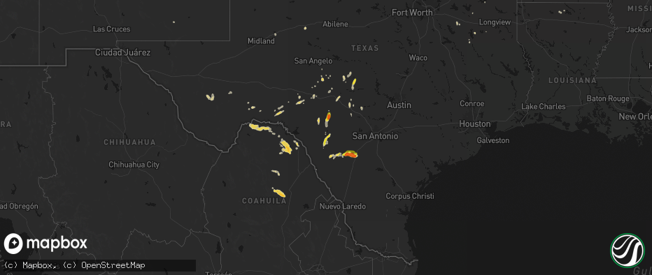
Hail Map on May 26, 2026
The weather event on May 26, 2026 includes Wind, Hail, and Tornado maps. 14 states and 251 cities were impacted and suffered possible damage. The total estimated number of properties impacted is 20,361.
Wind
Hail
Tornado
20,361
Estimated number of impacted properties by a 1.00" hail or larger1,330
Estimated number of impacted properties by a 1.75" hail or larger39
Estimated number of impacted properties by a 2.50" hail or largerStates Impacted by Hail Map on May 26, 2026
Storm reports
Montana
| Date | Description |
|---|---|
| 05/26/20266:53 PM CDT | Asos station kolf wolf point airport. |
| 05/26/20266:45 PM CDT | Mesonet station mttos toston bridge us-287 mp 87.0. |
| 05/26/20265:30 PM CDT | Wind and lightning damaged trees. |
| 05/26/20264:30 PM CDT | Mesonet station mtlbt lambert mt-200 mp 45.0. |
| 05/26/202612:15 AM CDT | Awos station ksbx 2 nnw shelby. |
| 05/25/20267:54 PM CDT | Mesonet station ekhm8 elkhorn raws - 8 w townsend. |
New Mexico
| Date | Description |
|---|---|
| 05/26/20266:29 PM CDT | Trained spotter found dime to quarter sized hail along u.s. Highway 62/180. |
Texas
| Date | Description |
|---|---|
| 05/26/20266:17 PM CDT | 2 inch hail reported via photo on fb. |
| 05/26/20265:42 PM CDT | 1 inch hail reported. |
| 05/26/20265:25 PM CDT | Hail report from 13 nne van horn. Nws storm spotter sent a report of quarter sized hail observed while on a walking trail off of hwy 54. |
| 05/26/20265:25 PM CDT | Reported via public. |
| 05/26/20265:21 PM CDT | Corrects previous tornado report from 9 n quemado. Brief tornado reported 1 mile sse of us 277. |
| 05/26/20265:21 PM CDT | Brief tornado reported 1 mile sse of us 277. |
| 05/26/20265:21 PM CDT | Corrects previous tornado report from 7 n quemado. Brief tornado reported 1 mile sse of us 277. |
| 05/26/20265:00 PM CDT | 60mph winds reported 5 miles east of pearsall. |
| 05/26/20264:47 PM CDT | Report from mping. |
| 05/26/20264:30 PM CDT | A local report indicates 1.25 inch wind near 1 SW Fredonia |
| 05/26/20264:15 PM CDT | 1 inch hail reported via media. |
| 05/26/20263:13 PM CDT | A local report indicates 62 MPH wind near 1 SSE Jayton |
| 05/26/20263:12 PM CDT | A local report indicates 1.25 inch wind near 11 S Montell |
| 05/26/20261:20 PM CDT | Measured by the west texas mesonet. |
| 05/26/202611:00 AM CDT | [landspout] emergency manager relayed several reports of a land spout in hereford as a weak storm developed over town. This was visually confirmed via nearby observati |
| 05/26/20266:39 AM CDT | Public weather station. |
| 05/26/20266:35 AM CDT | A local report indicates 63 MPH wind near CC Airport |
| 05/26/20263:41 AM CDT | Measured by lrd awos. |
| 05/26/20262:42 AM CDT | Trees down in the inverness forest neighborhood. One down on a car... Another on a house. |
| 05/26/20261:49 AM CDT | Public weather station. |
| 05/26/20261:24 AM CDT | Awos station knog orange grove. |
| 05/26/20261:07 AM CDT | Large trees down near cr 1767 and cr 440. |
| 05/26/202612:57 AM CDT | Debris in the road near cr 248 and cr 1353. |
| 05/25/202611:06 PM CDT | Smiley fire department responding to possible down power lines. |
| 05/25/202610:25 PM CDT | Mesonet station twb16 1.1 ne new berlin |
| 05/25/202610:20 PM CDT | A tornado survey team found damage that supported the existence of a short-lived ef-1 tornado. The tornado may have started just east of linne road. The most significan |
| 05/25/20269:40 PM CDT | Metal sheet barn knocked over along with branch thrown into a kitchen window. Picture shared on facebook. |
| 05/25/20268:23 PM CDT | A large tree was blown down and partly blocking barnard avenue in sabinal. |
| 05/25/20268:06 PM CDT | Half dollar to ping pong size hail south of center point. Time estimated via radar. |
| 05/25/20268:01 PM CDT | Report from mping quarter inch hail. |
| 05/25/20267:45 PM CDT | Em reports a rv pushed on its side from wind. |
| 05/25/20267:42 PM CDT | Photo via storm chaser on twitter. |
| 05/25/20267:38 PM CDT | 79 mph wind gust with a handheld anemometer. |
| 05/25/20267:25 PM CDT | Downed tree in uvalde. Time estimated via radar. |
| 05/25/20267:25 PM CDT | Spotter reported 2.5 inch diameter branches down in city uvalde. |
Minnesota
| Date | Description |
|---|---|
| 05/26/20265:40 PM CDT | Portion of sheet metal ripped off of roof. A tree was also reported to be knocked down. |
| 05/26/20265:20 PM CDT | A local report indicates 1.00 inch wind near 2 W Dads Corner |
| 05/26/20264:58 PM CDT | Report from mping: quarter |
| 05/25/20268:00 PM CDT | A local report indicates 1.00 inch wind near Adams |
Florida
| Date | Description |
|---|---|
| 05/26/20264:53 PM CDT | Asos station kpgd punta gorda. |
| 05/26/20264:39 PM CDT | A resident of the area reported seeing the tornado lifting debris over an open field in a construction site. The circulation dissipated shortly after. |
Georgia
| Date | Description |
|---|---|
| 05/26/20266:40 PM CDT | Public reports tree down near the intersection of indian island drive and highway 24. |
| 05/26/20266:20 PM CDT | Fire department reports a downed power pole and lines near the intersection of 1st street and old mcintyre road. |
| 05/26/20266:20 PM CDT | Fire department reports downed power lines near the intersection of 1st street and highway 441. |
| 05/26/20266:20 PM CDT | Fire department reports multiple trees and power lines down along pine circle. |
| 05/26/20264:45 PM CDT | Georgia department of transportation reports tree down near the intersection of highway 219 and saint anthony drive. |
Kentucky
| Date | Description |
|---|---|
| 05/26/20266:49 PM CDT | Resends previous tstm wnd dmg report from 1 wsw frenchburg due to iris error message. Tree down on power lines along indian creek road. Time estimated by radar. |
| 05/26/20266:20 PM CDT | Social media report with photo of tree down on power line on lower cane creek rd. Time and location estimated. |
| 05/26/20266:18 PM CDT | Delayed report. Pictures on social media of downed trees at the end of leach hollow road off of ky-213 and ky-464. Exact time estimated by radar. Possible tornado. |
| 05/26/20266:15 PM CDT | County em reports dozens of large trees down in the hatchers creek rd and lowers hatchers creek rd areas. Power lines are also down in this area with power outages. Pos |
| 05/26/20266:14 PM CDT | County em reports dozens of large trees down in the hatchers creek rd and lowers hatchers creek rd areas. Power lines are also down in this area with power outages. Pos |
| 05/26/20266:13 PM CDT | Delayed report. Pictures on social media of downed power lines along boone creek road off ky-213 north of stanton. Possible tornado. Exact time estimated by radar. |
Idaho
| Date | Description |
|---|---|
| 05/26/20264:10 PM CDT | Half dollar to ping pong size hail near beaver and wolverine way in tetonia. Public also reports a broken sky light and windshield. |
Wisconsin
| Date | Description |
|---|---|
| 05/26/20266:06 PM CDT | Report from mping half dollar. |
| 05/26/20265:46 PM CDT | Estimated quarter-size hail. Appearance in photos suggests larger than quarters. |
| 05/26/20265:21 PM CDT | A local report indicates 1.00 inch wind near 2 SW Stanberry |
| 05/26/20264:54 PM CDT | Trees and power lines down. |
Cities Impacted by Hail Map on May 26, 2026
- Alpine, TX
- Fort Davis, TX
- Big Spring, TX
- Dryden, TX
- Silverton, TX
- Lockney, TX
- Crystal City, TX
- Richton, MS
- Tulia, TX
- Happy, TX
- Frankston, TX
- Palestine, TX
- Colorado City, TX
- Brackettville, TX
- Loraine, TX
- Uvalde, TX
- Bullard, TX
- Flint, TX
- Batesville, TX
- Roscoe, TX
- Quemado, TX
- Duncan, OK
- Comanche, OK
- Ellisville, MS
- Laurel, MS
- Comstock, TX
- Sonora, TX
- Canton, TX
- Athens, TX
- Mineola, TX
- Eustace, TX
- Waubun, MN
- Pearsall, TX
- Twin Valley, MN
- Barksdale, TX
- Camp Wood, TX
- Eldorado, TX
- Dubach, LA
- Jayton, TX
- Celina, TX
- Menard, TX
- Rocksprings, TX
- Del Rio, TX
- Kerrville, TX
- Hendrum, MN
- Junction, TX
- Dilley, TX
- Mason, TX
- Tetonia, ID
- Perley, MN
- Leakey, TX
- Whitesboro, TX
- Driggs, ID
- Pittsburg, TX
- Leesburg, TX
- Felt, ID
- Ashton, ID
- Harper, TX
- Bernice, LA
- Moose, WY
- Ulen, MN
- Hext, TX
- Brady, TX
- Comfort, TX
- Fredericksburg, TX
- Mountain Home, TX
- McGrath, MN
- Fredonia, TX
- Voca, TX
- Marietta, OK
- Melvin, TX
- Bonham, TX
- Ivanhoe, TX
- Pillager, MN
- Yellowstone National Park, WY
- Exeland, WI
- Loyal, OK
- Kingfisher, OK
- Brainerd, MN
- Merrifield, MN
- Wolf Point, MT
- Antigo, WI
- Finlayson, MN
- Danbury, WI
- Lambert, MT
- Brockton, MT
- Park Rapids, MN
- Ada, MN
- Mcgregor, MN
- Springbrook, WI
- Art, TX
- Neillsville, WI
- San Saba, TX
- Richland Springs, TX
- Staples, MN
- Motley, MN
- Pontotoc, TX
- Spooner, WI
- Tipton, OK
- Bigfoot, TX
- Moore, TX
- Carlsbad, NM
- Doss, TX
- Willow City, TX
- Boerne, TX
- Headrick, OK
- Hayward, WI
- Austin, MN
- Rose Creek, MN
- Stone Lake, WI
- Adams, MN
- Sandstone, MN
- Isle, MN
- Stonewall, TX
- Ringgold, TX
- Nocona, TX
- Llano, TX
- Omega, OK
- Elkton, MN
- Richey, MT
- Dexter, MN
- McIntyre, GA
- Gordon, GA
- Watonga, OK
- Morriston, FL
- Charlotte, TX
- Deerwood, MN
- Irwinton, GA
- Eagle Pass, TX
- Johnson City, TX
- Jourdanton, TX
- Aitkin, MN
- Garrison, MN
- Couderay, WI
- Saint Ansgar, IA
- La Pryor, TX
- Lyle, MN
- Sarona, WI
- Henrietta, TX
- Ryan, OK
- Salt Flat, TX
- Round Mountain, TX
- Stacyville, IA
- Marble Falls, TX
- Bertram, TX
- Burnet, TX
- Electra, TX
- Blanco, TX
- Osage, IA
- Emmons, MN
- Georgetown, TX
- Leander, TX
- Liberty Hill, TX
- Carrizo Springs, TX
- Big Wells, TX
- Bandera, TX
- Sabinal, TX
- Center Point, TX
- Florence, TX
- Horseshoe Bay, TX
- Pleasanton, TX
- Glenville, MN
- Hye, TX
- Clarks Grove, MN
- Albert Lea, MN
- Medina, TX
- Yancey, TX
- D Hanis, TX
- Balmorhea, TX
- Harrold, TX
- Davidson, OK
- Little Cedar, IA
- Cotulla, TX
- Gooding, ID
- Devine, TX
- Hondo, TX
- Punta Gorda, FL
- Pipe Creek, TX
- Hayward, MN
- Northwood, IA
- Alden, MN
- Encinal, TX
- Frederick, OK
- Bulverde, TX
- Lake Mills, IA
- Twin Lakes, MN
- Poteet, TX
- Monahans, TX
- Wink, TX
- Marquez, TX
- Bremond, TX
- Spring Branch, TX
- Franklin, TX
- Kosse, TX
- Laredo, TX
- Groesbeck, TX
- Scarville, IA
- Thompson, IA
- Jewett, TX
- Seguin, TX
- San Antonio, TX
- Schertz, TX
- La Vernia, TX
- Cibolo, TX
- Converse, TX
- Jbsa Ft Sam Houston, TX
- Adkins, TX
- Marion, TX
- Saint Hedwig, TX
- Kingsbury, TX
- Gonzales, TX
- Leesville, TX
- Nixon, TX
- Cost, TX
- Smiley, TX
- Wrightsboro, TX
- Luling, TX
- Harwood, TX
- Waelder, TX
- Donie, TX
- Fairmont, MN
- Shiner, TX
- Muldoon, TX
- Rosanky, TX
- Flatonia, TX
- Realitos, TX
- Goliad, TX
- Freer, TX
- Concepcion, TX
- Hallettsville, TX
- San Diego, TX
- Victoria, TX
- Tivoli, TX
- Alice, TX
- Refugio, TX
- Robstown, TX
- Bloomington, TX
- Port Lavaca, TX
- Bishop, TX
- Agua Dulce, TX
- Zapata, TX
- Warwick, ND
- Hebbronville, TX
- Benavides, TX
- Premont, TX
- Kingsville, TX
- Riviera, TX
- Sarita, TX
- Corpus Christi, TX
- Woodsboro, TX
- Beeville, TX