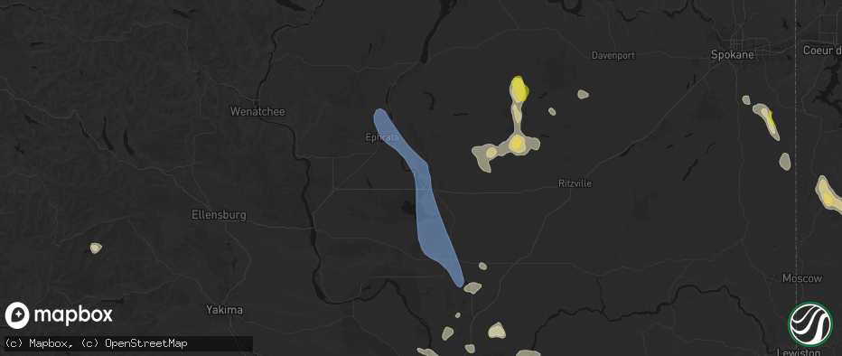
Hail Map in Moses Lake, WA on May 28, 2026
The weather event in Moses Lake, WA on May 28, 2026 includes Hail and Wind maps. 8 states and 145 cities were impacted and suffered possible damage. The total estimated number of properties impacted is 0.
Hail
Wind
0
Estimated number of impacted properties by a 1.00" hail or larger0
Estimated number of impacted properties by a 1.75" hail or larger0
Estimated number of impacted properties by a 2.50" hail or largerStorm reports in Moses Lake, WA
Moses Lake, WA
| Date | Description |
|---|---|
| 05/27/202610:51 PM CDT | A local report indicates 66 MPH wind near 6 NNW Moses Lake |
| 05/27/202610:50 PM CDT | Public reports several trees down in and around moses lake including large branches at montlake park blocking playground equipment. |
| 05/27/202610:40 PM CDT | Large poplar tree snapped. |
| 05/27/202610:35 PM CDT | Measurement on personal weather station. Also thunderstorm wind damage - 60 ft maple tree damaged. |
All States Impacted by Hail Map on May 28, 2026
All Cities Impacted by Hail Map on May 28, 2026
- Jacksboro, TX
- Bridgeport, TX
- Felda, FL
- Jordan Valley, OR
- Paradise, TX
- Santo, TX
- Springtown, TX
- Poolville, TX
- Perrin, TX
- Weatherford, TX
- Riverside, OR
- Gordon, TX
- Burns, OR
- Albany, TX
- Princeton, OR
- Lipan, TX
- Stephenville, TX
- Capitan, NM
- Crane, OR
- Mescalero, NM
- Azle, TX
- Bluff Dale, TX
- Breckenridge, TX
- Weston, CO
- Aledo, TX
- Neihart, MT
- Strawn, TX
- Council, ID
- Mccall, ID
- Aguilar, CO
- Whitt, TX
- Millsap, TX
- Seneca, OR
- Baird, TX
- Cresson, TX
- Lucile, ID
- Cambridge, ID
- Carbon, TX
- Gorman, TX
- White Bird, ID
- Naches, WA
- Trinidad, CO
- Ranger, TX
- Granbury, TX
- Godley, TX
- Richland, OR
- Canyon City, OR
- Cottonwood, ID
- Big Sandy, MT
- John Day, OR
- Cut Bank, MT
- Dublin, TX
- Baker City, OR
- Haines, OR
- Union, OR
- Prineville, OR
- Mount Vernon, OR
- Pilot Rock, OR
- Mitchell, OR
- Stanford, MT
- Moccasin, MT
- Folsom, NM
- Kalispell, MT
- Jefferson, CO
- Clinton, MT
- Long Creek, OR
- Monument, OR
- Babb, MT
- Stamford, TX
- Whitlash, MT
- Trinchera, CO
- Fernwood, ID
- Saint Maries, ID
- Kimberly, OR
- Anson, TX
- Galata, MT
- Bailey, CO
- Grant, CO
- Stites, ID
- Kooskia, ID
- Stanley, NM
- Kamiah, ID
- Grangeville, ID
- Grenville, NM
- Chester, MT
- Orofino, ID
- Fossil, OR
- Wallace, ID
- Weippe, ID
- Ione, OR
- Heppner, OR
- Pierce, ID
- Browning, MT
- Condon, OR
- Deary, ID
- Rule, TX
- Santa Fe, NM
- Haskell, TX
- Shelby, MT
- Drummond, MT
- Model, CO
- Desmet, ID
- Buffalo, MT
- Potlatch, ID
- Bovill, ID
- Bonner, MT
- Elk River, ID
- Boardman, OR
- Tensed, ID
- Toston, MT
- Fairfield, WA
- Latah, WA
- Odessa, WA
- Tekoa, WA
- Pasco, WA
- Weinert, TX
- Prescott, WA
- Plummer, ID
- Arlington, OR
- Prosser, WA
- Bickleton, WA
- Donnelly, ID
- Ritzville, WA
- Valleyford, WA
- Spangle, WA
- Eltopia, WA
- Wilbur, WA
- Mabton, WA
- Mesa, WA
- Connell, WA
- Richland, WA
- Goldendale, WA
- Sagle, ID
- Kingston, ID
- Othello, WA
- Moses Lake, WA
- Sandpoint, ID
- Marlin, WA
- Harrington, WA
- Des Moines, NM
- Warden, WA
- Soap Lake, WA
- Ephrata, WA
- Choteau, MT
- Fairfield, MT


