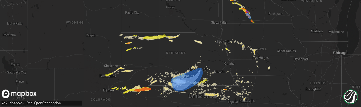
Hail Map in Nebraska on June 20, 2019
The weather event in Nebraska on June 20, 2019 includes Hail, Wind, and Tornado maps. 18 states and 713 cities were impacted and suffered possible damage. The total estimated number of properties impacted is 6,822.
Hail
Wind
Tornado
6,822
Estimated number of impacted properties by a 1.00" hail or larger30
Estimated number of impacted properties by a 1.75" hail or larger0
Estimated number of impacted properties by a 2.50" hail or largerStorm reports in Nebraska
Nebraska
| Date | Description |
|---|---|
| 06/20/20196:30 PM CDT | . |
| 06/20/20196:15 PM CDT | Hail fell for five minutes. |
| 06/20/20197:20 AM CDT | At 1220 AM MDT, a severe thunderstorm was located 10 miles northeast of Ashby, or 41 miles west of Mullen, moving east at 35 mph. HAZARD...60 mph wind gusts and half dollar size hail. SOURCE...Radar indicated. IMPACT...Hail damage to vehicles is expected. Expect wind damage to roofs, siding, and trees. Locations impacted include... Whitman, Carr Lake, Duluth, Hire, Whitman Road crossing the North Branch of the Middle Loup River, Sevenmile Hill, Hecla, Intersection of Highway 61 and Survey Valley Road, Weir and Mother Lake.This includes the following highways... Highway 2 between mile markers 149 and 178. Highway 61 between mile markers 161 and 186. |
| 06/20/20196:57 AM CDT | Tree down. |
| 06/20/20196:55 AM CDT | . |
| 06/20/20196:52 AM CDT | A local report indicates 60 MPH wind near FAIRBURY |
| 06/20/20196:34 AM CDT | At 1134 PM CDT, severe thunderstorms were located along a line extending from near Bertrand to near Hollinger to near Prairie View, moving east at 45 mph. HAZARD...70 mph wind gusts and quarter size hail. SOURCE...Radar indicated. IMPACT...Hail damage to vehicles is expected. Expect considerable tree damage. Wind damage is also likely to mobile homes, roofs, and outbuildings. Locations impacted include... Holdrege, Phillipsburg, Alma, Arapahoe, Oxford, Bertrand, Elwood, Beaver City, Orleans, Loomis, Holbrook, Funk, Stamford, Republican City, Prairie View, Long Island, Edison, Atlanta, Glade and Smithfield. |
| 06/20/20196:25 AM CDT | At 1124 PM CDT, severe thunderstorms were located along a line extending from 9 miles northwest of Funk to Bertrand, moving north at 25 mph. HAZARD...60 mph wind gusts and quarter size hail. SOURCE...Radar indicated. IMPACT...Hail damage to vehicles is expected. Expect wind damage to roofs, siding, and trees. Locations impacted include... Elm Creek, Bertrand, Overton and Loomis. This includes Interstate 80 between mile markers 239 and 263. |
| 06/20/20195:57 AM CDT | Mesonet station knesuper3. |
| 06/20/20195:50 AM CDT | Mesonet station knedaven5. |
| 06/20/20195:39 AM CDT | At 1039 PM CDT, severe thunderstorms were located along a line extending from 3 miles north of McCook to 7 miles northwest of Selden, moving northeast at 40 mph. HAZARD...60 mph wind gusts and quarter size hail. SOURCE...Radar indicated. IMPACT...Hail damage to vehicles is expected. Expect wind damage to roofs, siding, and trees. Locations impacted include... McCook, Norton, Oberlin, Indianola, Bartley, Selden and Norcatur. |
| 06/20/20195:35 AM CDT | At 1035 PM CDT, a severe thunderstorm was located near Cambridge, or 27 miles east of McCook, moving northeast at 40 mph. HAZARD...Ping pong ball size hail and 60 mph wind gusts. SOURCE...Radar indicated. IMPACT...People and animals outdoors will be injured. Expect hail damage to roofs, siding, windows, and vehicles. Expect wind damage to roofs, siding, and trees. Locations impacted include... Cambridge, Arapahoe, Elwood and Holbrook. |
| 06/20/20195:25 AM CDT | At 1024 AM CDT, a severe thunderstorm was located 9 miles northeast of Orchard, or 27 miles east of O'neill, moving southeast at 40 mph. HAZARD...60 mph wind gusts and half dollar size hail. SOURCE...Radar indicated. IMPACT...Hail damage to vehicles is expected. Expect wind damage to roofs, siding, and trees. Locations impacted include... Plainview, Creighton, Brunswick, Royal, The Highway 14 And 59 Junction and Ashfall Fossil Beds State Historical Park. |
| 06/20/20195:00 AM CDT | At 959 PM MDT, a severe thunderstorm was located 12 miles west of Medicine Lake, or 28 miles east of Gordon, moving east at 25 mph. HAZARD...60 mph wind gusts and half dollar size hail. SOURCE...Radar indicated. IMPACT...Hail damage to vehicles is expected. Expect wind damage to roofs, siding, and trees. Locations impacted include... Medicine Lake, Highway 61 Crossing The Niobrara River, Intersection of Highway 61 and Shadbolt Road, Indian Hill and Highway 61 crossing the Snake River.This includes Highway 61 between mile markers 198 and 218. |
| 06/20/20194:58 AM CDT | At 957 AM CDT, a severe thunderstorm was located 7 miles northeast of Page, or 16 miles east of O'neill, moving southeast at 30 mph. HAZARD...60 mph wind gusts and quarter size hail. SOURCE...Radar indicated. IMPACT...Hail damage to vehicles is expected. Expect wind damage to roofs, siding, and trees. Locations impacted include... Orchard, Royal, The Highway 14 And 59 Junction and Ashfall Fossil Beds State Historical Park. |
| 06/20/20194:10 AM CDT | Radar estimated time. |
| 06/20/20194:10 AM CDT | A local report indicates 1.00 inch wind near NELSON |
| 06/20/20193:25 AM CDT | At 825 PM MDT, a severe thunderstorm was located near Rushville, moving east at 55 mph. HAZARD...60 mph wind gusts and half dollar size hail. SOURCE...Radar indicated. IMPACT...Hail damage to vehicles is expected. Expect wind damage to roofs, siding, and trees. Locations impacted include... Rushville, Hay Springs, Clinton, Billys Lake, Lone Butte, Intersection of Beaver Creek Road and White Clay Creek Road, Highway 27 crossing the Niobrara River, Highway 250 crossing the Niobrara River, Intersection of Highway 87 and Antelope Road, Walgren Lake State Recreation Area and Intersection of Highway 27 and Mills Road.This includes the following highways... Highway 20 between mile markers 74 and 100. Highway 250 between mile markers 30 and 48. |
| 06/20/20192:30 AM CDT | A local report indicates 64 MPH wind near WACO |
| 06/20/20191:58 AM CDT | At 657 PM MDT, a severe thunderstorm was located near Harrison, or 35 miles east of Lusk, moving east at 30 mph. HAZARD...60 mph wind gusts and half dollar size hail. SOURCE...Radar indicated. IMPACT...Hail damage to vehicles is expected. Expect wind damage to roofs, siding, and trees. Locations impacted include... Crawford, Whitney Lake, Fort Robinson Campground and Fort Robinson. |
| 06/20/20191:52 AM CDT | Report of a power line across highway 6 2.5 miles west of minden. Courtesy ntv. |
| 06/20/20191:36 AM CDT | Corrects previous tstm wnd dmg report from 1 sse hastings. Reports from public of trees down. Courtesy of ntv. |
| 06/20/20191:35 AM CDT | Mping report of 3-inch tree limbs broken. |
| 06/20/20191:35 AM CDT | 3 hog barns and 2 pole barns were damaged or destroyed. Metal was in the trees to the west and spread out about a quarter of a mile. Some tree damage at the residence.. |
| 06/20/20191:35 AM CDT | Report of 14 to 16 inch tree down against house. Time approximated from report and radar. |
| 06/20/20191:34 AM CDT | Tree limb approximately 8 to 10 inches in diameter down a residence. Time estimate. |
| 06/20/20191:34 AM CDT | Heavy rain... Estimated winds 55 with gusts to 60 mph. |
| 06/20/20191:33 AM CDT | Pivot tower overturned. |
| 06/20/20191:30 AM CDT | Estimated tree limbs down in town up to 2 inches in diameter. Report relayed via emergency manager. Time estimated by radar. |
| 06/20/20191:30 AM CDT | Public report of several trees down at southern hills. Report from social media. |
| 06/20/20191:26 AM CDT | A local report indicates 75 MPH wind near 3 NW INLAND |
| 06/20/20191:24 AM CDT | Powerline down across 12th street near saunders ave. |
| 06/20/20191:20 AM CDT | Estimated 6 inch diameter tree limbs are down near the fairgrounds. |
| 06/20/20191:18 AM CDT | A local report indicates 67 MPH wind near 4 ESE HASTINGS |
| 06/20/20191:15 AM CDT | A local report indicates 60 MPH wind near 2 SSE HASTINGS |
| 06/20/20191:15 AM CDT | Emergency manager reports large limbs down and some uprooted trees in hastings. Time estimated. |
| 06/20/20191:14 AM CDT | A local report indicates 65 MPH wind near 2 N PAULINE |
| 06/20/20191:11 AM CDT | A local report indicates 58 MPH wind near 3 SW PROSSER |
| 06/20/20191:09 AM CDT | A local report indicates 68 MPH wind near 3 ESE JUNIATA |
| 06/20/20191:05 AM CDT | A local report indicates 60 MPH wind near KENESAW |
| 06/20/20191:05 AM CDT | Multiple pictures on social media of large trees damaged. |
| 06/20/20191:00 AM CDT | Measured by a lacrosse home weather station. |
| 06/20/201912:58 AM CDT | A local report indicates 75 MPH wind near 1 NNE NORMAN |
| 06/20/201912:54 AM CDT | Measured on davis vantage pro2 weather station. Anemometer is mounted on windmill approximately 35-40 feet off the ground. Several trees were uprooted in the area as we |
| 06/20/201912:49 AM CDT | Estimated 70 mph with 3/4 inch hail. |
| 06/20/201912:46 AM CDT | A local report indicates 59 MPH wind near 1 ESE CAMPBELL |
| 06/20/201912:45 AM CDT | Corrects previous tstm wnd dmg report from 3 w minden. Report of a power line across highway 6 2.5 miles west of minden. Courtesy ntv. Radar estimated time. |
| 06/20/201912:43 AM CDT | Delayed report. Social media photo showing approximately 8-10 inch healthy tree limb snapped. Time estimated from radar. |
| 06/20/201912:42 AM CDT | A local report indicates 63 MPH wind near 3 ENE AXTELL |
| 06/20/201912:38 AM CDT | A local report indicates 59 MPH wind near HILDRETH |
| 06/20/201912:37 AM CDT | Report of extensive tree damage... Including a branch through the roof of a house and branches pushed deep into the ground. A grain bin was also severely damaged. |
| 06/20/201912:35 AM CDT | At 534 PM MDT, a severe thunderstorm was located 7 miles east of Kilpatrick Lake, or 14 miles west of Alliance, moving east at 40 mph. HAZARD...60 mph wind gusts and quarter size hail. SOURCE...Radar indicated. IMPACT...Hail damage to vehicles is expected. Expect wind damage to roofs, siding, and trees. Locations impacted include... Alliance, Hemingford, Wild Horse Butte, Kilpatrick Lake, Berea and Alliance Airport.This replaces the Severe Thunderstorm Warning which was previously in effect for the warned area. |
| 06/20/201912:29 AM CDT | A local report indicates 70 MPH wind near 4 E RAGAN |
| 06/20/201912:20 AM CDT | Mesonet station nb054 ragan 5w. |
| 06/20/201912:19 AM CDT | Report from social media of approximately 3 to 4 inch tree limbs down with estimated 70 mph winds. |
| 06/20/201912:04 AM CDT | Reports of numerous trees damaged in town. Some very large trees blocking roads. |
| 06/20/201912:04 AM CDT | Heavy rain and estimated quarter size hail. |
| 06/19/201911:57 PM CDT | Unofficial wind gust. |
| 06/19/201911:56 PM CDT | Delayed report. Power pole snapped just south of oxford. Time estimated from radar. |
| 06/19/201911:55 PM CDT | 4 inch tree branches downed. Combination of strong winds and hail caused garden damage. Time estimated from radar |
| 06/19/201911:54 PM CDT | At 454 PM MDT, a severe thunderstorm was located over Lake Alice, or 8 miles north of Scottsbluff, moving east at 30 mph. HAZARD...60 mph wind gusts and quarter size hail. SOURCE...Radar indicated. IMPACT...Hail damage to vehicles is expected. Expect wind damage to roofs, siding, and trees. Locations impacted include... Kilpatrick Lake, Lake Minatare Campground, Lake Minatare and Lake Alice. |
| 06/19/201911:54 PM CDT | A local report indicates 72 MPH wind near 4.7 NNW OXFORD |
| 06/19/201911:53 PM CDT | A local report indicates 73 MPH wind near 1 N OXFORD |
| 06/19/201911:38 PM CDT | Picture of three snapped power poles on hwy 136 just north of edison. Estimated 100mph winds in this area. Time estimated from radar and other nearby reports. |
| 06/19/201911:30 PM CDT | Hail estimated to be at least quarter size. Strong winds also reported |
| 06/19/201911:27 PM CDT | A local report indicates 60 MPH wind near 2 N ARAPAHOE |
| 06/19/201911:18 PM CDT | Relayed reports of several uprooted cottonwood trees in arapahoe. Time estimated from radar. |
| 06/19/201911:16 PM CDT | Estimated 5 to 6 inch diameter tree limb blown down in town. |
| 06/19/201911:15 PM CDT | Relayed report of several trees down and concrete markers knocked over at golf course. Several broken power poles in the area as well. Time estimated from radar. |
| 06/19/201911:14 PM CDT | Corrects previous location of report from 4n of holbrook. Grain bin and outbuilding destroyed. Shingle damage to home. Irrigation pipe was blown up to one half mile. |
| 06/19/201911:14 PM CDT | This location was reported incorrectly. The correct location is holbrook 2ne. |
| 06/19/201911:00 PM CDT | Social media photo of partial removal of roof on metal outbuilding. Time estimated from radar. |
| 06/19/201910:53 PM CDT | Delayed report. Tremendous amounts of mostly small hail. Drifts of hail still existed at sunrise on the mrng of the 21st. One farmer reported 800-900 acres of corn were |
| 06/19/201910:36 PM CDT | A local report indicates 59 MPH wind near 2 NNE CAMBRIDGE |
| 06/19/201910:17 PM CDT | A local report indicates 1.00 inch wind near 7 SE GORDON |
| 06/19/201910:17 PM CDT | A local report indicates 60 MPH wind near 7 SE GORDON |
| 06/19/201910:17 PM CDT | Estimated 60 mph wind with pebble size hail. |
| 06/19/20199:48 PM CDT | At 247 AM CDT/147 AM MDT/, a severe thunderstorm was located 13 miles southwest of Thedford, moving east at 40 mph. HAZARD...70 mph wind gusts and half dollar size hail. SOURCE...Radar indicated. IMPACT...Hail damage to vehicles is expected. Expect considerable tree damage. Wind damage is also likely to mobile homes, roofs, and outbuildings. Locations impacted include... Highway 83 crossing The Dismal River, Brown Lake and Shanklin Bluff.This includes Highway 83 between mile markers 117 and 143. |
| 06/19/20199:43 PM CDT | At 242 AM CDT/142 AM MDT/, a severe thunderstorm was located 7 miles south of Mullen, moving southeast at 45 mph. HAZARD...70 mph wind gusts and half dollar size hail. SOURCE...Radar indicated. IMPACT...Hail damage to vehicles is expected. Expect considerable tree damage. Wind damage is also likely to mobile homes, roofs, and outbuildings. Locations impacted include... Highway 83 crossing The Dismal River, Brown Lake and Shanklin Bluff.This includes Highway 83 between mile markers 117 and 143. |
| 06/19/20199:00 PM CDT | At 200 AM CDT/100 AM MDT/, a severe thunderstorm was located over Whitman, or 25 miles west of Mullen, moving east at 40 mph. HAZARD...70 mph wind gusts and half dollar size hail. SOURCE...Radar indicated. IMPACT...Hail damage to vehicles is expected. Expect considerable tree damage. Wind damage is also likely to mobile homes, roofs, and outbuildings. This severe thunderstorm will be near... Mullen around 140 AM MDT.Other locations impacted by this severe thunderstorm include CarrLake, Hecla, Highway 97 crossing the Dismal River, Kelso, Weir andShimmons Lake.This includes the following highways... Highway 2 between mile markers 164 and 199. Highway 97 between mile markers 46 and 72. |
| 06/19/20198:50 PM CDT | Nickel to quarter size hail in chadron. |
| 06/19/20198:29 PM CDT | A local report indicates 60 MPH wind near 2 S WHITNEY |
| 06/19/20197:23 PM CDT | A local report indicates 1.00 inch wind near 1 ESE ALLIANCE |
All States Impacted by Hail Map on June 20, 2019
Cities Impacted by Hail Map on June 20, 2019
- Fort Morgan, CO
- Effingham, KS
- Lancaster, KS
- Sac City, IA
- Lake View, IA
- Wood Lake, NE
- Eustis, NE
- Harrison, NE
- Moorhead, IA
- Runnells, IA
- Prairie City, IA
- Hayes Center, NE
- Wallace, NE
- Blackville, SC
- Diller, NE
- Odell, NE
- Blakely, GA
- Endicott, NE
- Steele City, NE
- Fairbury, NE
- Pampa, TX
- Redwood Falls, MN
- Akron, CO
- Odebolt, IA
- Schaller, IA
- Early, IA
- Leavenworth, KS
- Bonner Springs, KS
- Platte City, MO
- Basehor, KS
- Waldron, MO
- Kansas City, MO
- Kansas City, KS
- Modoc, SC
- Lincolnton, GA
- Plum Branch, SC
- Funk, NE
- Bertrand, NE
- Loomis, NE
- Elm Creek, NE
- Overton, NE
- Holdrege, NE
- Hardy, NE
- Bellvue, CO
- Loveland, CO
- Pierce, CO
- Nunn, CO
- Fort Collins, CO
- McCook, NE
- Bloomington, NE
- Lenora, KS
- Randolph, KS
- Grand Island, NE
- Dannebrog, NE
- Saint Libory, NE
- Carpenter, WY
- Pine Bluffs, WY
- Grover, CO
- Eatonton, GA
- Madison, GA
- Fitzgerald, GA
- Dana, IA
- Jefferson, IA
- Grand Junction, IA
- Arabi, GA
- Ashburn, GA
- Merriman, NE
- Cody, NE
- Clarkfield, MN
- Granite Falls, MN
- Cope, CO
- Padroni, CO
- Merino, CO
- Stoneham, CO
- Sterling, CO
- New Raymer, CO
- Shenandoah, IA
- Blue Earth, MN
- Strasburg, CO
- Harleyville, SC
- Holly Hill, SC
- Wood Lake, MN
- Echo, MN
- Boelus, NE
- Cairo, NE
- Burchard, NE
- Liberty, NE
- Hanover, KS
- Skidmore, MO
- Graham, MO
- Marion, SC
- Florence, SC
- Bennett, CO
- Onawa, IA
- Westboro, MO
- Northboro, IA
- Guyton, GA
- Rincon, GA
- Marsland, NE
- Dimock, SD
- Parkston, SD
- Mount Vernon, SD
- Ethan, SD
- Wilsonville, NE
- Hendley, NE
- Norton, KS
- Morgan, MN
- Springfield, MN
- Comfrey, MN
- Sleepy Eye, MN
- Truman, MN
- Saint James, MN
- Lewisville, MN
- Hanska, MN
- Clements, MN
- Madelia, MN
- Yuma, CO
- Idalia, CO
- Anton, CO
- Joes, CO
- Wray, CO
- Saint Francis, KS
- Kirk, CO
- Vernon, CO
- Imperial, NE
- Vermillion, KS
- Briggsdale, CO
- Republic, KS
- Byron, NE
- Superior, NE
- Webber, KS
- Abbeville, SC
- Bradley, SC
- McCormick, SC
- Calhoun Falls, SC
- Tignall, GA
- Elberton, GA
- Troy, SC
- Mount Carmel, SC
- Salley, SC
- Tifton, GA
- Red Cloud, NE
- Bladen, NE
- Inavale, NE
- Durham, NC
- Whitney, NE
- Crawford, NE
- Monticello, GA
- Juliette, GA
- Melrose, IA
- Albia, IA
- Denver, CO
- Aurora, CO
- Evans, GA
- Augusta, GA
- Page, NE
- Brunswick, NE
- Orchard, NE
- Royal, NE
- Winnetoon, NE
- Benkelman, NE
- Parks, NE
- Sycamore, GA
- Afton, TN
- Limestone, TN
- Chuckey, TN
- Stratton, NE
- Palisade, NE
- Trenton, NE
- Belview, MN
- Creedmoor, NC
- Knoxville, TN
- Greeleyville, SC
- Corsicana, TX
- Perry, IA
- Ogden, IA
- Dixon, NE
- Seneca, KS
- Sabetha, KS
- Oneida, KS
- Nelson, NE
- Saint George, KS
- Wamego, KS
- Scottsbluff, NE
- Alliance, NE
- Woodrow, CO
- Centralia, KS
- Craig, MO
- Fairfax, MO
- Colby, KS
- Karval, CO
- Lexington, NE
- Smithfield, NE
- Amherst, NE
- Kearney, NE
- Riverdale, NE
- Byers, CO
- Hanley Falls, MN
- Sloan, IA
- Hoxie, KS
- Selden, KS
- Stamford, NE
- Long Island, KS
- Deer Trail, CO
- Wetmore, KS
- Vona, CO
- Atchison, KS
- Nortonville, KS
- Arapahoe, NE
- Republican City, NE
- Winterset, IA
- Prole, IA
- Patterson, IA
- Saint Charles, IA
- Milford, NE
- Enigma, GA
- Saint Paul, NE
- Pamplico, SC
- Effingham, SC
- Ault, CO
- Bolivia, NC
- Cummings, KS
- Mankato, KS
- Glen Elder, KS
- Thomaston, GA
- Molena, GA
- Woodbury, GA
- Farnam, NE
- Lusk, WY
- Naponee, NE
- Delia, KS
- Mayetta, KS
- Bellevue, TX
- Appling, GA
- Clarks Hill, SC
- Oberlin, KS
- Herndon, KS
- Champion, NE
- Garrison, UT
- Washta, IA
- Quimby, IA
- Pawnee City, NE
- Axtell, KS
- Baileyville, KS
- Palmer, KS
- Aurora, KS
- Glasco, KS
- Clyde, KS
- Green, KS
- Concordia, KS
- Morganville, KS
- Miltonvale, KS
- Jamestown, KS
- Clay Center, KS
- Clifton, KS
- Leonardville, KS
- Scottsville, KY
- Cordova, SC
- Orangeburg, SC
- Neeses, SC
- Cope, SC
- Rushville, MO
- Correctionville, IA
- Seward, NE
- Chester, NE
- Hebron, NE
- Macon, NC
- Sellers, SC
- Mullins, SC
- Davenport, NE
- Oak, NE
- Fullerton, NE
- Palmer, NE
- Bishopville, SC
- Telford, TN
- Greeneville, TN
- Statesboro, GA
- Metter, GA
- Register, GA
- Ariton, AL
- Brundidge, AL
- Clio, AL
- Axtell, NE
- Minden, NE
- Blue Hill, NE
- Indianola, NE
- Friend, NE
- Cordova, NE
- Exeter, NE
- Formoso, KS
- Courtland, KS
- Jewell, KS
- Rembert, SC
- Preston, GA
- Parrott, GA
- Olsburg, KS
- Westmoreland, KS
- Haigler, NE
- Wauneta, NE
- Atwood, KS
- Shickley, NE
- Branchville, VA
- Boykins, VA
- Forsyth, GA
- Downs, KS
- Esbon, KS
- Chadron, NE
- Beaver City, NE
- Paton, IA
- Hubbell, NE
- Narka, KS
- Munden, KS
- Jennings, KS
- Churdan, IA
- Dearborn, MO
- Gower, MO
- Edgerton, MO
- Skipperville, AL
- Banks, AL
- Troy, AL
- Holbrook, NE
- Edison, NE
- Oxford, NE
- Cambridge, NE
- Rebecca, GA
- Chula, GA
- Barnes, KS
- Waterville, KS
- Blue Rapids, KS
- Onaga, KS
- Maitland, MO
- Maryville, MO
- Hawkinsville, GA
- Pineview, GA
- Unadilla, GA
- Streetman, TX
- Enders, NE
- Grovetown, GA
- North Augusta, SC
- Moorefield, NE
- Lebanon, NE
- Norcatur, KS
- Danbury, NE
- Vesta, MN
- Sanborn, MN
- Seaforth, MN
- Cottonwood, MN
- Lamberton, MN
- Winnebago, MN
- Milligan, NE
- Easton, MO
- Saint Joseph, MO
- Carlton, GA
- Repton, AL
- York, NE
- McCool Junction, NE
- Rexford, KS
- Burlington, CO
- Hemingford, NE
- Plattsburg, MO
- Mound City, MO
- Deshler, NE
- Alma, NE
- Littleton, NC
- Granada, MN
- Bushnell, NE
- Frankfort, KS
- Glendo, WY
- Columbia, NC
- Summerton, SC
- Pinewood, SC
- Stanberry, MO
- Creighton, NE
- Oneill, NE
- Auburn, IA
- Lindon, CO
- Oelrichs, SD
- Valentine, NE
- Ainsworth, NE
- Springview, NE
- Johnstown, NE
- Americus, GA
- Plains, GA
- Dawson, GA
- Kenesaw, NE
- Heartwell, NE
- Montgomery, AL
- Ramer, AL
- Forsyth, MT
- Orleans, NE
- Williston, SC
- Pickering, MO
- Burlington Junction, MO
- Sacred Heart, MN
- Tonganoxie, KS
- Glade, KS
- Phillipsburg, KS
- Mount Ayr, IA
- Valdosta, GA
- Arlington, GA
- Morgan, GA
- Torrington, WY
- Beloit, KS
- Manning, SC
- New Zion, SC
- Norway, SC
- Bird City, KS
- Hay Springs, NE
- Rushville, NE
- Kilgore, NE
- Crookston, NE
- Nenzel, NE
- Gordon, NE
- Ellsworth, NE
- Lakeside, NE
- Hoyt, KS
- Osceola, IA
- Haddam, KS
- Lyons, NE
- Rosalie, NE
- Eutawville, SC
- Crow Agency, MT
- Leary, GA
- Newton, GA
- Rowesville, SC
- Ravenna, NE
- Newville, AL
- Clopton, AL
- Branchville, SC
- Bowman, SC
- Home, KS
- Marysville, KS
- Smithville, GA
- Manhattan, KS
- Hillsborough, NC
- Springfield, SC
- Waco, NE
- Kirwin, KS
- Guide Rock, NE
- Saint Marys, KS
- Rossville, KS
- Elmore, MN
- Seibert, CO
- Logan, KS
- Abbeville, AL
- Shorterville, AL
- Eckley, CO
- Genoa, CO
- Rock Port, MO
- Ludell, KS
- Camden, SC
- Lebanon, KS
- Denmark, SC
- Bamberg, SC
- Galva, IA
- Ida Grove, IA
- Holstein, IA
- Falls City, NE
- Ocilla, GA
- Boone, IA
- Turney, MO
- Albany, GA
- Leesburg, GA
- Breda, IA
- Carroll, IA
- Bouton, IA
- Woodward, IA
- Caryville, TN
- Arcadia, IA
- Wood River, NE
- Netawaka, KS
- Whiting, KS
- Columbia, AL
- Whiting, IA
- Wymore, NE
- Worden, MT
- Watkins, CO
- McFall, MO
- Albany, MO
- Cuba, KS
- Agenda, KS
- Belleville, KS
- Everest, KS
- Randall, KS
- Norway, KS
- Scandia, KS
- Smithville, MO
- Trimble, MO
- Bartley, NE
- Elwood, NE
- De Kalb, MO
- Faucett, MO
- Agra, KS
- Glidden, IA
- Cuthbert, GA
- Farragut, IA
- Hamburg, IA
- Fairfield, TX
- Shelton, NE
- Rockville, NE
- Muscotah, KS
- Culbertson, NE
- Henderson, NE
- Hampton, NE
- Coin, IA
- Cross, SC
- Swan, IA
- Adel, IA
- Gaylord, KS
- Osborne, KS
- Flagler, CO
- Hazard, NE
- Tarkio, MO
- Guilford, MO
- Lawrence, NE
- Castalia, NC
- Louisburg, NC
- Maywood, NE
- Emmett, KS
- Curtis, NE
- Imogene, IA
- Emerson, NE
- Nehawka, NE
- Avoca, NE
- Jansen, NE
- Plymouth, NE
- Fort Leavenworth, KS
- Colquitt, GA
- Horton, KS
- Belgrade, NE
- Gibbon, NE
- Green Pond, SC
- Alton, KS
- Portis, KS
- Salem, NE
- Giltner, NE
- Aurora, NE
- Van Meter, IA
- Warwick, GA
- Amity, MO
- Commerce City, CO
- Maysville, MO
- Easton, KS
- Agency, MO
- Goff, KS
- Corning, KS
- Linn, KS
- Greenleaf, KS
- Pierson, IA
- Benedict, NE
- Weston, MO
- Edgar, NE
- Ong, NE
- Carleton, NE
- Ruskin, NE
- Sutton, NE
- Atlanta, NE
- Odessa, NE
- Pleasanton, NE
- Belvue, KS
- Groom, TX
- Rippey, IA
- Minburn, IA
- Lovilia, IA
- Moravia, IA
- Wellfleet, NE
- De Soto, IA
- De Soto, GA
- Cordele, GA
- Cobb, GA
- Oakfield, GA
- Myrtle Beach, SC
- Athens, TX
- Strang, NE
- McDonald, KS
- Hollenberg, KS
- Morrowville, KS
- Mahaska, KS
- Stromsburg, NE
- Polk, NE
- Conway, SC
- Asheboro, NC
- Fairmont, NE
- Lenox, IA
- Claxton, GA
- Poulan, GA
- Sylvester, GA
- Diagonal, IA
- Gresham, NE
- Sergeant Bluff, IA
- Sioux City, IA
- Salix, IA
- Bronson, IA
- Nashville, NC
- Waycross, GA
- Wathena, KS
- Elsie, NE
- Franklin, NE
- Riverton, NE
- Lohrville, IA
- Vance, SC
- Beaver, IA
- Moncure, NC
- Cozad, NE
- Lumber City, GA
- McRae Helena, GA
- Hazlehurst, GA
- Kimball, NE
- Bern, KS
- Dresden, KS
- Bogue, KS
- Plainview, NE
- Darlington, MO
- Jamestown, SC
- Lake City, IA
- Wall Lake, IA
- Iliff, CO
- Tyndall, SD
- Truro, IA
- Beaver Crossing, NE
- Dorchester, NE
- Bruning, NE
- Belvidere, NE
- Washington, KS
- Kingstree, SC
- Barnard, MO
- Bolckow, MO
- Warrenton, NC
- Albion, NE
- Reynolds, NE
- Pattonsburg, MO
- Graham, TX
- Olney, TX
- Bradshaw, NE
- Rosebud, MT
- Minneota, MN
- Wilcox, NE
- Clearmont, MO
- Forest City, MO
- Maxwell, NE
- Savannah, MO
- Amazonia, MO
- Andalusia, AL
- Madrid, IA
- Jefferson, SD
- Auburn, NE
- Otoe, NE
- Wray, GA
- Lathrop, MO
- Ty Ty, GA
- Verdigre, NE
- Cawker City, KS
- Hubbard, NE
- Waterbury, NE
- Dawson, IA
- Jamaica, IA
- Alcolu, SC
- Juniata, NE
- Laporte, CO
- Recluse, WY
- Weston, WY
- Gillette, WY
- Jonesborough, TN
- Columbia, SC
- Cayce, SC
- Kensington, KS
- Inland, NE
- Trumbull, NE
- Hildreth, NE
- Holstein, NE
- Athol, KS
- Harvard, NE
- Almena, KS
- Clay Center, NE
- Fairfield, NE
- Roseland, NE
- Alda, NE
- Prairie View, KS
- Ayr, NE
- Saronville, NE
- Campbell, NE
- Smith Center, KS
- Upland, NE
- Marquette, NE
- Deweese, NE
- Hastings, NE
- Doniphan, NE
- Central City, NE
- Chapman, NE
- Phillips, NE
- Glenvil, NE
- Blanch, NC
- Oxford, NC
- Ringgold, VA
- Alton, VA
- Providence, NC
- Roxboro, NC
- Milton, NC
- Pelham, NC
- Semora, NC
- Virgilina, VA
- Timberlake, NC
- Hurdle Mills, NC
- Mebane, NC
- Rougemont, NC
- Burlington, NC
- Prospect Hill, NC
- Yanceyville, NC
- Leasburg, NC
- New Ulm, MN
- Wanda, MN
- Darfur, MN
- Amboy, MN