Hail Map in Wisconsin on July 12, 2015
The weather event in Wisconsin on July 12, 2015 includes Hail map. 22 states and 653 cities were impacted and suffered possible damage. The total estimated number of properties impacted is 166.
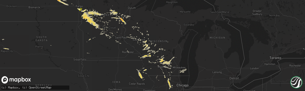
Hail
166
Estimated number of impacted properties by a 1.00" hail or larger0
Estimated number of impacted properties by a 1.75" hail or larger0
Estimated number of impacted properties by a 2.50" hail or largerStorm reports in Wisconsin
Wisconsin
| Date | Description |
|---|---|
| 07/12/201511:35 AM CDT | Nickel to quarter size hail for approx 5 minutes. Heavy rainfall with water ponding on streets in low spots also observed. |
| 07/12/20156:45 AM CDT | 2.25 inch hail |
| 07/12/20155:55 AM CDT | A local report indicates 62 MPH wind near KENOSHA |
| 07/12/20155:06 AM CDT | Widespread tree damage across southwest sheboygan county |
| 07/12/20155:04 AM CDT | Widespread trees down across walworth county |
| 07/12/20155:01 AM CDT | Numerous trees down from genesee to mukwonago. |
| 07/12/20155:00 AM CDT | Tree down across road. |
| 07/12/20155:00 AM CDT | Multiple trees snapped or uprooted. Time estimated from radar. |
| 07/12/20154:59 AM CDT | Trees down across much of western rock county. |
| 07/12/20154:59 AM CDT | Three 2-foot diamter trees downed...roof damage with shingles blown off on north island on eagle spring lake. Damage estimated at 15k dollars. |
| 07/12/20154:51 AM CDT | Large tree limb snapped off. Fell onto mailbox. |
| 07/12/20154:50 AM CDT | Large tree limb snapped off at pleasant valley cemetery. |
| 07/12/20154:49 AM CDT | Large maple tree and 20-25 ft pine tree blown down. |
| 07/12/20154:48 AM CDT | Tree damage across washington county. |
| 07/12/20154:40 AM CDT | Tree uprooted on a house in hobart. |
| 07/12/20154:40 AM CDT | A local report indicates 60 MPH wind near SUAMICO |
| 07/12/20154:35 AM CDT | Power lines down in city. |
| 07/12/20154:30 AM CDT | Power out on the north and east side of the city. |
| 07/12/20154:30 AM CDT | No power in city of kimberly. |
| 07/12/20154:29 AM CDT | Large tree snapped. Tree fell on and damaged house. Picture relayed via facebook. |
| 07/12/20154:29 AM CDT | Roof off of house. |
| 07/12/20154:29 AM CDT | Measured on a home weather station. |
| 07/12/20154:29 AM CDT | Trees snapped and uprooted in city. |
| 07/12/20154:27 AM CDT | Measured with a home weather station. Relayed via facebook. |
| 07/12/20154:27 AM CDT | Measured with a home weather station. Relayed via facebook. |
| 07/12/20154:25 AM CDT | Hail with damaging winds. 50 ft tree down in yard |
| 07/12/20154:25 AM CDT | Trees and power lines down in city. |
| 07/12/20154:16 AM CDT | Relayed via facebook. |
| 07/12/20154:16 AM CDT | Relayed via facebook. |
| 07/12/20154:15 AM CDT | Trees and power lines down. |
| 07/12/20154:15 AM CDT | Many trees down... At least one on a house and one on powerlines. Relayed via twitter. |
| 07/12/20154:10 AM CDT | 10-15 inch tree branches downed. Relayed via facebook. |
| 07/12/20154:10 AM CDT | Relayed via facebook. |
| 07/12/20154:07 AM CDT | Numerous reports of trees down and arcing power lines across southern fond du lac county. |
| 07/12/20154:05 AM CDT | Measured on a home weather station. |
| 07/12/20154:05 AM CDT | Measured on a home weather station. |
| 07/12/20154:05 AM CDT | Wind speed measured via home weather station. Relayed via facebook. |
| 07/12/20154:05 AM CDT | Numerous large trees down in area. A few outbuildings damaged or destroyed. Nws storm survey esitmates 90-110 mph winds. |
| 07/12/20154:05 AM CDT | Part of a roof blown off a barn. |
| 07/12/20154:05 AM CDT | Multiple trees down |
| 07/12/20154:05 AM CDT | Power lines and branches down. |
| 07/12/20153:51 AM CDT | Trees and power lines down. |
| 07/12/20153:45 AM CDT | Widespread tree damage across green lake county. Berlin in particular has sustained a considerable amount of tree damage. |
| 07/12/20153:37 AM CDT | A local report indicates 60 MPH wind near CLINTONVILLE |
| 07/12/20153:35 AM CDT | Trees down across much of southern sauk county. |
| 07/12/20153:30 AM CDT | Asos station lone rock tri-county airport /lnr/ |
| 07/12/20153:30 AM CDT | Large trees down in the city at hwy 22 and yy. |
| 07/12/20153:25 AM CDT | Trees down across much of marquette county |
| 07/12/20152:51 AM CDT | Trees down in castle rock park. |
| 07/12/20152:50 AM CDT | Trees down. Time estimated via radar. |
| 07/12/20152:50 AM CDT | Trees down in petenwell county park. |
| 07/12/20152:48 AM CDT | Mesonet station necedah /nehw3/ |
| 07/12/20152:33 AM CDT | Trees down in the city. |
| 07/12/20152:33 AM CDT | Asos station volk field airport /vok/ |
| 07/12/20152:00 AM CDT | Tree down in road |
| 07/12/20151:50 AM CDT | Wires down. |
| 07/12/20151:50 AM CDT | 10-12 inch dead apple tree downed. |
| 07/12/20151:37 AM CDT | Power lines down. |
| 07/12/20151:00 AM CDT | Tree down |
| 07/12/201512:46 AM CDT | Power lines down. |
| 07/12/201512:41 AM CDT | Power lines down. |
| 07/12/201512:30 AM CDT | A few small trees toppled. Portion of town out of power from 1230 am to 0400 am. |
| 07/12/201512:00 AM CDT | Several trees down |
| 07/11/201511:45 PM CDT | Small trees knocked down near border with chippewa county. |
| 07/11/201511:10 PM CDT | Couple small trees pushed over in arland wi |
| 07/11/201511:10 PM CDT | A couple large 2 foot trees were blown down |
| 07/11/201510:45 PM CDT | Delayed report via social media of a live 7 foot pine tree down. Time radar estimated. |
| 07/11/201510:25 PM CDT | Delayed report of a power line down. Time radar estimated. |
| 07/11/201510:00 PM CDT | Trees down |
All States Impacted by Hail Map on July 12, 2015
Cities Impacted by Hail Map on July 12, 2015
- Harvey, ND
- Sandstone, MN
- Brook Park, MN
- Pine City, MN
- Hinckley, MN
- Grantsburg, WI
- Newnan, GA
- Thief River Falls, MN
- Garfield, MN
- Glenwood, MN
- Barrett, MN
- Kensington, MN
- Lowry, MN
- Evansville, MN
- Ashby, MN
- Elbow Lake, MN
- Villard, MN
- Alexandria, MN
- Farwell, MN
- Brandon, MN
- Onamia, MN
- Isle, MN
- Wahkon, MN
- Merrillan, WI
- Neillsville, WI
- Black River Falls, WI
- Juneau, WI
- Horicon, WI
- Michigan, ND
- Lakota, ND
- Aitkin, MN
- Belle Fourche, SD
- Plain, WI
- Loganville, WI
- North Freedom, WI
- Quemado, NM
- Belcourt, ND
- Holdingford, MN
- Bowlus, MN
- Barronett, WI
- Cumberland, WI
- Mcgregor, MN
- Sturgeon Lake, MN
- McGrath, MN
- Osseo, WI
- Kensal, ND
- Courtenay, ND
- Solway, MN
- Rio, WI
- Deforest, WI
- Fall River, WI
- Marshall, WI
- Beaver Dam, WI
- Columbus, WI
- Carrington, ND
- Swanville, MN
- Rockford, IL
- Winnebago, IL
- Durand, IL
- Shirland, IL
- Rockton, IL
- Warrens, WI
- Pittsville, WI
- Newfolden, MN
- Viking, MN
- Argyle, MN
- Perham, MN
- Battle Lake, MN
- Bluffton, MN
- Richville, MN
- Ottertail, MN
- Deer Creek, MN
- Erhard, MN
- Fergus Falls, MN
- Wadena, MN
- Underwood, MN
- New York Mills, MN
- Dent, MN
- Henning, MN
- Farmington, NM
- Bloomfield, NM
- Racine, WI
- Humbird, WI
- Stanley, WI
- Boyd, WI
- Cathay, ND
- New Rockford, ND
- Cherry Valley, IL
- Kirkland, IL
- Belvidere, IL
- Dekalb, IL
- Waterman, IL
- Somonauk, IL
- Cortland, IL
- Hinckley, IL
- Kingston, IL
- Clare, IL
- Sycamore, IL
- Babbitt, MN
- Watertown, WI
- Johnson Creek, WI
- Sylvania, GA
- Ontario, WI
- Rockland, WI
- Stoddard, WI
- Viroqua, WI
- Bangor, WI
- Genoa, WI
- Norwalk, WI
- Westby, WI
- Coon Valley, WI
- Chaseburg, WI
- Elroy, WI
- Kendall, WI
- Sparta, WI
- La Crosse, WI
- Wilton, WI
- Hillsboro, WI
- Cashton, WI
- Maple Lake, MN
- Buffalo, MN
- Rogers, ND
- Moriarty, NM
- Saint Olaf, IA
- Vergas, MN
- Chapel Hill, NC
- Capitan, NM
- Moorhead, MN
- Horace, ND
- Comstock, MN
- Grand Forks, ND
- Plano, IL
- Mayer, MN
- New Germany, MN
- Watertown, MN
- Howard Lake, MN
- Winsted, MN
- Earlville, IA
- Delhi, IA
- Manchester, IA
- Greeley, IA
- Delaware, IA
- Edgewood, IA
- Hopkinton, IA
- Beloit, KS
- Glen Elder, KS
- Saint John, ND
- Crosby, MN
- Wendell, MN
- Brooten, MN
- Campbell, MN
- Dalton, MN
- Foxhome, MN
- Breckenridge, MN
- Sauk Centre, MN
- Rothsay, MN
- Hoffman, MN
- Elizabeth, MN
- Piedmont, SD
- Rapid City, SD
- Box Elder, SD
- Cubero, NM
- Bemidji, MN
- Velva, ND
- Richmond, MN
- Avon, MN
- Isabella, MN
- Ochopee, FL
- Eagle Bend, MN
- Owingsville, KY
- Willcox, AZ
- Benson, AZ
- Sturtevant, WI
- Burkesville, KY
- Celina, TN
- Hilham, TN
- Woodbine, GA
- Mauston, WI
- Valley City, ND
- Sanborn, ND
- Union Center, SD
- Newell, SD
- Whitleyville, TN
- Moss, TN
- Gainesboro, TN
- Wolford, ND
- Eau Claire, WI
- Dazey, ND
- Luverne, ND
- Grafton, ND
- Pisek, ND
- Forest River, ND
- Minto, ND
- Saint Thomas, ND
- Drayton, ND
- Eleva, WI
- Mondovi, WI
- Fessenden, ND
- Glenfield, ND
- Oriska, ND
- Grace City, ND
- Maddock, ND
- Wimbledon, ND
- Sheyenne, ND
- Rugby, ND
- Oberon, ND
- Sparta, TN
- Holcombe, WI
- New Auburn, WI
- Sharon, ND
- Pardeeville, WI
- Montello, WI
- Baraboo, WI
- Poynette, WI
- Lodi, WI
- Merrimac, WI
- Wisconsin Dells, WI
- Portage, WI
- Wyocena, WI
- Dalton, WI
- Grygla, MN
- Plainfield, WI
- Hancock, WI
- Bancroft, WI
- Tellico Plains, TN
- Hixton, WI
- Hermosa, SD
- Keystone, SD
- Lancaster, KY
- Lakeville, MN
- Littlefork, MN
- Evansville, WI
- Orfordville, WI
- Brodhead, WI
- Thompson, ND
- East Grand Forks, MN
- Camp Douglas, WI
- Necedah, WI
- Glen Haven, WI
- Lancaster, WI
- Bloomington, WI
- White Oak, GA
- Waverly, GA
- Bushnell, FL
- Crary, ND
- Oslo, MN
- Alvarado, MN
- Leland, IL
- Souris, ND
- Burnett, WI
- Nicholasville, KY
- Wilmore, KY
- Harrodsburg, KY
- Granville, ND
- Kennedy, MN
- Elkhorn, WI
- Roanoke, AL
- Esmond, ND
- Stephen, MN
- Vining, MN
- Clitherall, MN
- Pomona Park, FL
- Georgetown, FL
- Crescent City, FL
- Pelican Rapids, MN
- Ixonia, WI
- Oconomowoc, WI
- Mora, MN
- Muscoda, WI
- Viola, WI
- Richland Center, WI
- New Lisbon, WI
- Stanford, KY
- Danville, KY
- Reeseville, WI
- Arlington, WI
- Lowell, WI
- Morrisonville, WI
- Sun Prairie, WI
- Waterloo, WI
- Emerado, ND
- York, ND
- Sheldon, WI
- Gilman, WI
- Chandler, MN
- Woodstock, MN
- Calhoun, GA
- Bertha, MN
- Hewitt, MN
- Norcross, MN
- Verndale, MN
- Aldrich, MN
- Staples, MN
- Nashua, MN
- Motley, MN
- Osakis, MN
- Chiefland, FL
- Franksville, WI
- Deerwood, MN
- Palmetto, GA
- Tomah, WI
- Ely, MN
- Finlayson, MN
- Poplar Grove, IL
- Esmond, IL
- Big Rock, IL
- Malta, IL
- Garden Prairie, IL
- Sandwich, IL
- Deer River, MN
- Maynard, MN
- Clara City, MN
- Red Lake Falls, MN
- Cold Spring, MN
- Saint Cloud, MN
- Ponemah, MN
- Baudette, MN
- Saint Michael, ND
- Devils Lake, ND
- Shakopee, MN
- Prior Lake, MN
- Nemo, SD
- Willard, WI
- Fairchild, WI
- Augusta, WI
- Moneta, VA
- Cornell, WI
- Bunnell, FL
- Barnesville, MN
- Melrose, WI
- Alma Center, WI
- Cushing, MN
- Strum, WI
- Prairie Du Chien, WI
- Bagley, WI
- Fort Totten, ND
- Minnewaukan, ND
- Oregon, WI
- Crookston, MN
- Beltrami, MN
- Cohutta, GA
- Apison, TN
- Harrison, TN
- Tunnel Hill, GA
- Chattanooga, TN
- Ooltewah, TN
- Ringgold, GA
- Eden Valley, MN
- Parkers Prairie, MN
- Isanti, MN
- Tijeras, NM
- Delano, MN
- Winslow, AZ
- Hilliard, FL
- Stanley, NM
- Christine, ND
- Maple Plain, MN
- Rockford, MN
- Salt Lick, KY
- Marengo, IL
- Euclid, MN
- Fall Creek, WI
- Saint Joseph, MN
- Clarksburg, OH
- Bremen, IN
- Goshen, IN
- Wakarusa, IN
- Nappanee, IN
- Big Falls, MN
- Arpin, WI
- Vesper, WI
- Campbellsport, WI
- Fond Du Lac, WI
- Eden, WI
- Hillpoint, WI
- Bisbee, ND
- Atlanta, GA
- Wolverton, MN
- Waite Park, MN
- Prewitt, NM
- Royalton, MN
- Long Prairie, MN
- Raleigh, NC
- Folkston, GA
- Thoreau, NM
- Panacea, FL
- Saint Hilaire, MN
- Rolla, ND
- Jackson, OH
- Reedsburg, WI
- Wheatland, ND
- Perry, FL
- Milton, FL
- Granton, WI
- Chili, WI
- Brownsville, MN
- Century, FL
- Pearl City, IL
- Cottage Grove, WI
- Dassel, MN
- Northome, MN
- Watkins, MN
- Englewood, TN
- Appleton, MN
- Greenville, AL
- Fort Deposit, AL
- Mekinock, ND
- Manvel, ND
- Askov, MN
- Willow River, MN
- Bruno, MN
- Apex, NC
- Willow Spring, NC
- Fuquay Varina, NC
- Holly Springs, NC
- Garner, NC
- Chetek, WI
- Cameron, WI
- Brooks, MN
- Woodland, AL
- Clarkfield, MN
- Pierson, FL
- Corona, NM
- Pie Town, NM
- Voltaire, ND
- Guttenberg, IA
- Holy Cross, IA
- Colesburg, IA
- Silver Lake, MN
- Lester Prairie, MN
- Paynesville, MN
- Boyd, MN
- Beloit, WI
- Granville, TN
- Pleasant Shade, TN
- Chippewa Falls, WI
- Tipton, KS
- Wilson, WI
- Woodville, WI
- Climax, MN
- Fisher, MN
- Wild Rose, WI
- Almond, WI
- Wautoma, WI
- Rochester, MN
- Hammond, WI
- Baldwin, WI
- Roberts, WI
- Towner, ND
- Marion, WI
- Kent, IL
- Lena, IL
- Stockton, IL
- Boca Grande, FL
- Outing, MN
- Fence Lake, NM
- Grants, NM
- Webster, FL
- Pensacola, FL
- Burtrum, MN
- Weyerhaeuser, WI
- Birchwood, WI
- Eau Claire, MI
- Cokato, MN
- Franklin, GA
- Albany, MN
- Karlstad, MN
- Worthington, IA
- Strawberry Point, IA
- Jordan, MN
- Durham, NC
- Cary, NC
- Belgrade, MN
- Hartford, MI
- Dowagiac, MI
- Benton Harbor, MI
- Merrifield, MN
- Nisswa, MN
- Salvisa, KY
- Lawrenceburg, KY
- Friendship, WI
- Versailles, KY
- Knapp, WI
- Glenwood City, WI
- Downing, WI
- Farmington, MN
- Northfield, MN
- Menomonie, WI
- Harvard, IL
- Darien, WI
- Andover, MN
- Anoka, MN
- Spencer, WI
- Hatton, ND
- Northwood, ND
- Boyceville, WI
- Endeavor, WI
- Brainerd, MN
- Slayton, MN
- Hannaford, ND
- Brooklyn, WI
- Niagara, ND
- Brownsville, WI
- Warren, MN
- Harper, OR
- Livingston, WI
- Montfort, WI
- Rice, MN
- Anamoose, ND
- Pillager, MN
- Pequot Lakes, MN
- Neosho, WI
- Browerville, MN
- Dunseith, ND
- Roscoe, MN
- Ayr, ND
- Rice Lake, WI
- Mikana, WI
- Martin, SC
- Cascade, IA
- Saint Francis, MN
- Carlos, MN
- Nelson, MN
- Cadott, WI
- Hillman, MN
- Pine Island, MN
- Nielsville, MN
- Strandquist, MN
- Goodridge, MN
- Barron, WI
- Taunton, MN
- Reynolds, ND
- Little Falls, MN
- Brimson, MN
- Loxley, AL
- Saint Johns, AZ
- Tolna, ND
- Petersburg, ND
- Dahlen, ND
- Kimball, MN
- Redgranite, WI
- Hesperus, CO
- Karlsruhe, ND
- Ettrick, WI
- Elkader, IA
- Garber, IA
- Fairmount, GA
- Rydal, GA
- Fairhope, AL
- Silverhill, AL
- Stone Lake, WI
- Springbrook, WI
- Darwin, MN
- Dundee, IA
- Volga, IA
- Dyersville, IA
- Elgin, IA
- Wadena, IA
- Mayville, WI
- Clyman, WI
- Windsor, WI
- Lomira, WI
- Verona, WI
- Emily, MN
- Ironton, MN
- Pierz, MN
- Gulf Shores, AL
- Hestand, KY
- Tompkinsville, KY
- Menomonee Falls, WI
- Floral City, FL
- Monticello, IA
- Grasston, MN
- Lexington, KY
- Arkdale, WI
- Greenwood, WI
- Owen, WI
- Marshfield, WI
- Dane, WI
- Black Earth, WI
- Mazomanie, WI
- Buchanan, MI
- Galien, MI
- Three Oaks, MI
- Crownpoint, NM
- Loyal, WI
- Lankin, ND
- Willow City, ND
- Miltona, MN
- Randolph, MN
- Wetumpka, AL
- Decatur, MI
- Cedar Key, FL
- Sharon, WI
- Fort Pierre, SD
- Dalton, GA
- Grand Rapids, MN
- Campbellsville, KY
- Fort McCoy, FL
- Sherrill, IA
- Spicer, MN
- Kandiyohi, MN
- Atwater, MN
- Grove City, MN
- Lawton, ND
- Brocket, ND
- Granite Falls, MN
- Colfax, WI
- Haugen, WI
- Winslow, IL
- Maple Park, IL
- Sugar Grove, IL
- Elburn, IL
- Donaldson, MN
- Avalon, WI
- Delavan, WI
- Whitewater, WI
- Shelly, MN
- Ada, MN
- Danbury, WI
- Waverly, MN
- Jefferson, WI
- Helenville, WI
- Sullivan, WI
- Cambridge, WI
- Lake Mills, WI
- Deerfield, WI
- Fort Atkinson, WI
- Madison, WI
- Houston, MN
- Caledonia, MN
- Davenport, ND
- Lawrence, MI
- Litchfield, MN
- Lublin, WI
- Rock Springs, WI
- Booth, AL
- Prattville, AL
- Hendrum, MN
- Massena, IA
- Withee, WI
- Saint George, GA
- Labelle, FL
- Moore Haven, FL
- Rocky Face, GA
- Elk Mound, WI
- Shannon, IL
- Spring Valley, WI
- Ree Heights, SD
- Sabin, MN
- Wannaska, MN
- Gatzke, MN
- Bottineau, ND