Hail Map on July 31, 2013
The weather event on July 31, 2013 includes Hail map. 17 states and 211 cities were impacted and suffered possible damage. The total estimated number of properties impacted is 52.
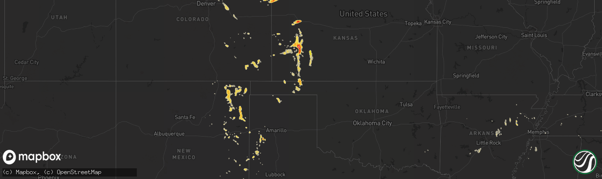
Hail
52
Estimated number of impacted properties by a 1.00" hail or larger76
Estimated number of impacted properties by a 1.75" hail or larger0
Estimated number of impacted properties by a 2.50" hail or largerStates Impacted by Hail Map on July 31, 2013
Storm reports
Colorado
| Date | Description |
|---|---|
| 07/30/201311:14 PM CDT | A local report indicates 1.25 inch wind near 11 NNE AKRON |
| 07/30/20139:40 PM CDT | Numerous power poles snapped in half in deer trail vicinity. Widepread power outages in central arapahoe county. |
| 07/30/20139:35 PM CDT | Power outages. |
| 07/30/20139:27 PM CDT | Power outages. |
| 07/30/20139:14 PM CDT | A local report indicates 1.75 inch wind near 1 S VERNON |
| 07/30/20139:14 PM CDT | Aluminum siding and roofing partially peeled off sheds. Minor tree damage. |
| 07/30/20139:03 PM CDT | A local report indicates 65 MPH wind near 3 NNE BYERS |
| 07/30/20139:01 PM CDT | A local report indicates 63 MPH wind near 1 E STRASBURG |
| 07/30/20138:30 PM CDT | A local report indicates 1.00 inch wind near 10 N BENNETT |
Alabama
| Date | Description |
|---|---|
| 07/31/20131:30 AM CDT | Several trees reported down sporadically across the county. Winds estimated around 40 mph. |
| 07/31/201312:00 AM CDT | Small oak tree fell on home. Winds estimated around 40 mph. |
Idaho
| Date | Description |
|---|---|
| 07/31/20136:55 PM CDT | Maximum gust from the arl site at dubois. |
| 07/31/20136:05 PM CDT | Maximum gust from the arl rover site. An additional gust to 58 mph occurred at 855 pm. |
| 07/31/20136:05 PM CDT | Maximum gust from the arl rover site. |
| 07/31/20135:45 PM CDT | Maximum gust from arl material fuels complex. |
| 07/31/20135:10 PM CDT | Maximum gust reported from the arco arl site. |
| 07/30/201311:05 PM CDT | Maximum gust from arl site at big southern summit. |
| 07/30/201310:00 PM CDT | Maximum gust recorded at base of howe peak. |
| 07/30/20139:16 PM CDT | Maximum gust from the itd site at inl puzzle. |
| 07/30/20138:35 PM CDT | Maximum gust from coxs well arl site. |
Oregon
| Date | Description |
|---|---|
| 07/30/20139:30 PM CDT | Quarter-size hail fell in thunderstorm hail duration 15 minutes |
| 07/30/20137:45 PM CDT | Miller lake campground. Lots of hail caused tents to collapse. |
Oklahoma
| Date | Description |
|---|---|
| 07/30/20137:50 PM CDT | Wind blown hail broke windows |
| 07/30/20137:50 PM CDT | A local report indicates 1.00 inch wind near 2 NW BOYD |
| 07/30/20137:10 PM CDT | A local report indicates 1.75 inch wind near 4 N FLORIS |
Wyoming
| Date | Description |
|---|---|
| 07/31/20136:24 PM CDT | A local report indicates 1.00 inch wind near 9 SSE TORRINGTON |
| 07/31/20135:10 PM CDT | One inch diameter hail on interstate 25 between 4 and 10 miles north of chugwater between mile markers 59 and 65. Wind gusts were also estimated around 50 mph and heavy |
| 07/31/20135:05 PM CDT | Event duration 20 minutes. |
| 07/31/20134:18 PM CDT | A local report indicates 60 MPH wind near 20 W ALBIN |
| 07/30/20137:50 PM CDT | A local report indicates 1.25 inch wind near MANVILLE |
Michigan
| Date | Description |
|---|---|
| 07/31/20135:03 PM CDT | Power lines down in engadine. |
| 07/31/20134:41 PM CDT | Estimated 60 mph winds at curtis with pea to nickel sized hail. Measured 1.25 inches of rain in 35 minutes. |
| 07/31/20132:50 PM CDT | A local report indicates 1.00 inch wind near MELSTRAND |
Nebraska
| Date | Description |
|---|---|
| 07/31/20136:43 PM CDT | Strong winds also occurred. |
| 07/31/20136:38 PM CDT | Also wind gusts to 50 mph. |
| 07/31/20136:25 PM CDT | A local report indicates 1.75 inch wind near MORRILL |
| 07/30/20137:50 PM CDT | A local report indicates 1.00 inch wind near HEMINGFORD |
Georgia
| Date | Description |
|---|---|
| 07/31/20133:39 PM CDT | Cema reports a tree down on powerline near the savannah conference hotel off governor treutlen circle. |
| 07/31/20133:39 PM CDT | Cema reports a tree down on highway 80 near i-95. |
| 07/31/20133:39 PM CDT | Cema reports a tree down on hamstead avenue near montgomery street. |
| 07/31/20132:57 PM CDT | Media relayed report of tree down in midway. |
Texas
| Date | Description |
|---|---|
| 07/30/201310:18 PM CDT | Estimated winds to be at least 60 mph |
| 07/30/20139:05 PM CDT | A local report indicates 1.75 inch wind near 7 N HEREFORD |
Arkansas
| Date | Description |
|---|---|
| 07/31/20136:18 PM CDT | Trees reported down on highway 16 in searcy. |
| 07/30/20139:30 PM CDT | Numerous trees down in bismarck as well as along highway 84 just east of town. |
| 07/30/20138:20 PM CDT | Several trees and large tree limbs down along highway 229 in haskell. |
| 07/30/20138:15 PM CDT | Tree reported down across highway 270 near big creek road. |
| 07/30/20137:52 PM CDT | Several trees and large tree limbs down along highway 229 in haskell. |
| 07/30/20137:50 PM CDT | Numerous trees and powerlines down in and around haskell. |
Kansas
| Date | Description |
|---|---|
| 07/31/20136:00 PM CDT | A local report indicates 1.00 inch wind near 4 S SUBLETTE |
| 07/31/20135:52 PM CDT | Golf ball to hen egg size hail in oakley. |
| 07/31/20135:50 PM CDT | Two reports within two blocks of each other. Time estimated from radar. Reports relayed via em. |
| 07/31/20135:48 PM CDT | A local report indicates 1.25 inch wind near OAKLEY |
| 07/31/20135:47 PM CDT | A local report indicates 1.50 inch wind near OAKLEY |
| 07/31/20135:45 PM CDT | A roof was partially torn off an office of a motel. Several large limbs were down as well. The wind speed was estimated at 70 mph. |
| 07/31/20135:37 PM CDT | A local report indicates 65 MPH wind near 10 NNW TICE |
| 07/31/20135:20 PM CDT | A local report indicates 1.25 inch wind near 4 W OAKLEY |
| 07/31/20135:12 PM CDT | This report was collected by the nssl shave program. |
| 07/31/20134:58 PM CDT | This report was collected by the nssl shave program. |
| 07/31/20134:54 PM CDT | Numerous reports of large tree limbs blocking streets within the city limits |
| 07/31/20134:54 PM CDT | A local report indicates 1.50 inch wind near 2 E GARDEN CITY |
| 07/31/20134:45 PM CDT | A local report indicates 60 MPH wind near 5 N DEERFIELD |
| 07/31/20134:40 PM CDT | A local report indicates 60 MPH wind near 5 N DEERFIELD |
| 07/31/20134:38 PM CDT | This report was collected by the nssl shave program. |
| 07/31/20134:35 PM CDT | This report was collected by the nssl shave program. |
| 07/31/20134:27 PM CDT | The spotter was located on the northeast side of garden city |
| 07/31/20134:27 PM CDT | Significant blowing dust was reported with the estimated wind gust producing one quarter mile visibility or less |
| 07/31/20134:27 PM CDT | This report was collected by the nssl shave program. |
| 07/31/20134:27 PM CDT | This report was collected by the nssl shave program. |
| 07/31/20134:20 PM CDT | A local report indicates 1.75 inch wind near 12 SE FRIEND |
| 07/31/20134:20 PM CDT | A local report indicates 60 MPH wind near 11 SSE CIMARRON |
| 07/31/20134:15 PM CDT | A local report indicates 1.00 inch wind near 3 W ENSIGN |
| 07/31/20134:08 PM CDT | This report was from the nssl shave program. |
| 07/31/20134:04 PM CDT | Hail stone was 3 inches by 1.25 inches but was found 45 minutes after the storm. |
| 07/31/20134:04 PM CDT | A few roof shingles were blown off a house and a one inch tree limb was down. |
| 07/31/20134:00 PM CDT | A local report indicates 67 MPH wind near 4 WSW FRIEND |
| 07/31/20134:00 PM CDT | This report was collected by the nssl shave program. |
| 07/31/20133:40 PM CDT | A local report indicates 1.00 inch wind near 1 NE SHALLOW WATER |
| 07/31/20133:36 PM CDT | A local report indicates 1.00 inch wind near 2 N HOWELL |
| 07/31/20133:35 PM CDT | This report was collected by the nssl shave program. |
| 07/31/20133:26 PM CDT | A local report indicates 1.00 inch wind near SCOTT CITY |
| 07/31/20133:12 PM CDT | Quarter sized hail and 50 to 60 mph winds |
| 07/30/20139:00 PM CDT | A local report indicates 1.50 inch wind near 4 NW ST. FRANCIS |
| 07/30/20139:00 PM CDT | Late report from last night |
| 07/30/20139:00 PM CDT | A local report indicates 1.75 inch wind near 8 NW ST. FRANCIS |
| 07/30/20138:45 PM CDT | Hail broke a window. |
South Carolina
| Date | Description |
|---|---|
| 07/31/20133:48 PM CDT | Warning point reported tree down on power lines near the intersection of freedom parkway and ford lane. |
| 07/31/20132:27 PM CDT | Warning point reported 2 trees down on point south road. |
Wisconsin
| Date | Description |
|---|---|
| 07/31/20135:00 PM CDT | Tree with 16 inch diameter blown. Estimated 60 mph wind. Outflow boundary identified on radar. |
Florida
| Date | Description |
|---|---|
| 07/31/20134:00 PM CDT | Alachua county emergency management reports trees downed by strong wind gusts near newnans lake in the vicinity gainesville. Time of damage estimated by radar imagery |
| 07/31/20133:15 PM CDT | Several power outages reported in the worthington springs area. Information passed on through social media. |
| 07/31/20133:12 PM CDT | A tree was reported across the road near nw 186th street and nw 62nd avenue. |
| 07/31/20133:10 PM CDT | A few tree limbs reported down relayed through ema office. |
| 07/31/20131:50 PM CDT | Large tree down with significant damage to house at 86190 pages dairy road. |
Cities Impacted by Hail Map on July 31, 2013
- Akron, CO
- Harrison, NE
- Marsland, NE
- Crenshaw, MS
- Wray, CO
- Saint Francis, KS
- Liberal, KS
- Kismet, KS
- Forgan, OK
- Turpin, OK
- Hugoton, KS
- Garden City, KS
- Scott City, KS
- Grinnell, KS
- Oakley, KS
- Monument, KS
- Ingalls, KS
- Hanceville, AL
- Cheyenne, WY
- Meriden, WY
- Roy, NM
- Sublette, KS
- Yoder, WY
- Burwell, NE
- Batesland, SD
- Lake City, FL
- Tribune, KS
- Cimarron, KS
- Grenville, NM
- Moscow, KS
- Tucumcari, NM
- Ensign, KS
- Bradford, AR
- Springfield, CO
- Garner, AR
- Beebe, AR
- Ward, AR
- Searcy, AR
- McRae, AR
- Ainsworth, NE
- Johnstown, NE
- Friona, TX
- Muleshoe, TX
- Des Moines, NM
- Springer, NM
- Gladstone, NM
- Fisher, AR
- Weiner, AR
- Hereford, TX
- Balko, OK
- Bennett, CO
- Nara Visa, NM
- Mosquero, NM
- Madison, FL
- Traskwood, AR
- Vernon, CO
- Morrill, NE
- Clayton, NM
- Bassett, NE
- Long Pine, NE
- Farwell, TX
- Counce, TN
- Marienthal, KS
- Holcomb, KS
- Metter, GA
- Conchas Dam, NM
- Elida, NM
- Wheatland, WY
- Chugwater, WY
- Guymon, OK
- Manville, WY
- Mitchell, NE
- Raton, NM
- Hickory Ridge, AR
- Amagon, AR
- Limon, CO
- Idalia, CO
- Eads, TN
- Germantown, TN
- Collierville, TN
- Kim, CO
- Savannah, GA
- Hooker, OK
- Healy, KS
- Broadwater, NE
- Bald Knob, AR
- Oil Trough, AR
- Pleasant Plains, AR
- Thida, AR
- Yemassee, SC
- Ridgeland, SC
- Coosawhatchie, SC
- Lamar, CO
- Hardesty, OK
- Crawford, NE
- Blountsville, AL
- Alachua, FL
- Gainesville, FL
- Punta Gorda, FL
- Deerfield, KS
- Kendall, KS
- Lakin, KS
- Satanta, KS
- Shingleton, MI
- Munising, MI
- Gruver, TX
- Deer Trail, CO
- Agate, CO
- Medon, TN
- Mercer, TN
- Yulee, FL
- Callahan, FL
- Newport, AR
- Hayneville, AL
- Tyler, AL
- Portales, NM
- Hemingford, NE
- Byers, CO
- Pep, NM
- Causey, NM
- Torrington, WY
- Syracuse, KS
- Beaver, OK
- Jetmore, KS
- Lyman, NE
- Dundee, MS
- Crescent, OR
- Higden, AR
- Melrose, NM
- Olney Springs, CO
- Mayo, FL
- Ellsworth, NE
- Lowndesboro, AL
- Selma, AL
- Green Cove Springs, FL
- Folsom, NM
- Hardeeville, SC
- Rincon, GA
- Martin, SD
- Gordon, NE
- Jonesboro, AR
- Bridgeport, NE
- Lusk, WY
- Richmond Hill, GA
- Malvern, AR
- Tavares, FL
- Douglas, WY
- Pritchett, CO
- Boaz, AL
- Altoona, AL
- Horton, AL
- Otis, CO
- Bismarck, AR
- Pine Apple, AL
- Maxwell, NM
- Lake Butler, FL
- Sarah, MS
- Hudson, CO
- Trumann, AR
- Sardis, MS
- Toone, TN
- Leoti, KS
- Dunnellon, FL
- Lecanto, FL
- Early Branch, SC
- Benton, AR
- San Jon, NM
- Port Wentworth, GA
- Pooler, GA
- Claxton, GA
- Pine Hill, AL
- Dublin, TX
- Midway, GA
- Fort Payne, AL
- Scottsbluff, NE
- Hawthorne, FL
- Lexington, TN
- Cash, AR
- Kit Carson, CO
- Dodge City, KS
- Walnut Ridge, AR
- Register, GA
- Osceola, AR
- Dyess, AR
- Warrior, AL
- Hayden, AL
- Loving, NM
- Ashville, AL
- Riceboro, GA
- Eads, CO
- Eckley, CO
- Wetmore, MI
- Saint Marys, GA
- Greenville, AL
- Hugo, CO
- Strasburg, CO
- Woodville, AL
- Amistad, NM
- Parsons, TN
- Tallahassee, FL
- Judsonia, AR
- Lepanto, AR
- Steele, AL
- Clarksdale, MS
- Lyon, MS
- Desdemona, TX
- Loveland, CO
- Franklin, TN
- Sumterville, FL
- Lawrenceburg, TN
- Leoma, TN