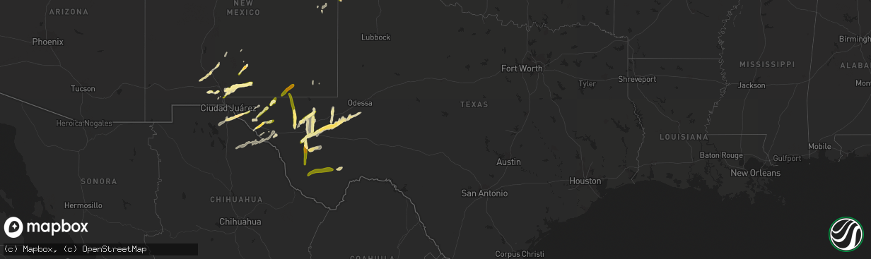
Hail Map in Texas on October 7, 2015
The weather event in Texas on October 7, 2015 includes Hail map. 4 states and 48 cities were impacted and suffered possible damage. The total estimated number of properties impacted is 4,089.
Hail
4,089
Estimated number of impacted properties by a 1.00" hail or larger524
Estimated number of impacted properties by a 1.75" hail or larger0
Estimated number of impacted properties by a 2.50" hail or largerStorm reports in Texas
Texas
| Date | Description |
|---|---|
| 10/07/20156:15 PM CDT | Roof torn off the coyanosa food center and pecan tree knocked down from wind gusts. |
| 10/07/20156:10 PM CDT | From the west texas mesonet |
| 10/07/20155:12 PM CDT | Trained spotter reports golfball sized hail at mile marker 95 along interstate 10 west of sierra blanca. |
| 10/06/20159:19 PM CDT | A local report indicates 1.00 inch wind near TOYAH |
| 10/06/20158:36 PM CDT | A local report indicates 1.75 inch wind near MCDONALD OBSERVATORY |
| 10/06/20158:10 PM CDT | Measured by the texas tech university west texas mesonet |
All States Impacted by Hail Map on October 7, 2015
Cities Impacted by Hail Map on October 7, 2015
- Marathon, TX
- Fort Davis, TX
- Fort Hancock, TX
- Hereford, TX
- Vega, TX
- Las Cruces, NM
- Pyote, TX
- Wink, TX
- Barstow, TX
- Pecos, TX
- White Sands Missile Range, NM
- Alamogordo, NM
- Rincon, NM
- Mesquite, NM
- Van Horn, TX
- Fabens, TX
- Tornillo, TX
- Clint, TX
- Jal, NM
- Sierra Blanca, TX
- Crane, TX
- Cloudcroft, NM
- Portales, NM
- Balmorhea, TX
- Dell City, TX
- Farwell, TX
- Bovina, TX
- Friona, TX
- Loving, NM
- Grandfalls, TX
- Coyanosa, TX
- La Mesa, NM
- Truth Or Consequences, NM
- Alpine, TX
- Fort Stockton, TX
- Chaparral, NM
- Anthony, NM
- Melrose, NM
- Salt Flat, TX
- Tularosa, NM
- Clovis, NM
- Floyd, NM
- Carlsbad, NM
- Marfa, TX
- Anthony, TX
- Canutillo, TX
- Blanding, UT
- Monticello, UT


