Hail Map on March 10, 2026
The weather event on March 10, 2026 includes Hail, Tornado, and Wind maps. 11 states and 1,358 cities were impacted and suffered possible damage. The total estimated number of properties impacted is 1,064,371.
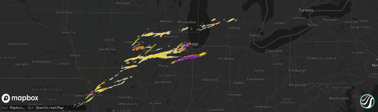
Hail
Tornado
Wind
1,064,371
Estimated number of impacted properties by a 1.00" hail or larger396,672
Estimated number of impacted properties by a 1.75" hail or larger259,271
Estimated number of impacted properties by a 2.50" hail or largerStates Impacted by Hail Map on March 10, 2026
Storm reports
Texas
| Date | Description |
|---|---|
| 03/10/20266:55 PM CDT | Report from mping: quarter |
| 03/10/20266:47 PM CDT | Delayed report. Storm spotter reported tennis ball sized hail 9 miles south of breckenridge. |
| 03/10/20266:47 PM CDT | Amateur radio relayed report of tennis ball sized hail in breckenridge. |
| 03/10/20266:45 PM CDT | Grapefruit sized hail reported. |
| 03/10/20266:45 PM CDT | Mesonet station ea002 3.9 n montell |
| 03/10/20266:40 PM CDT | Picture received of approximately 2 inch diameter hail. |
| 03/10/20266:36 PM CDT | Hail up to 1 inch in diameter. Time estimated via radar. |
| 03/10/20266:30 PM CDT | Report of sheds damaged and picture of metal roof material stuck on power line in sonora. Time estimated based on radar. |
| 03/10/20266:22 PM CDT | Separate storm from initial gust reported earlier. |
| 03/10/20266:15 PM CDT | A local report indicates 58 MPH wind near 4 NNW Goree |
| 03/10/20266:14 PM CDT | On hwy 82. |
| 03/10/20266:05 PM CDT | A local report indicates 63 MPH wind near 4 NNW Goree |
| 03/10/20266:00 PM CDT | Texas parks and wildlife reported quarter sized hail. |
| 03/10/20265:55 PM CDT | Large tree branch |
| 03/10/20265:55 PM CDT | Corrects previous tstm wnd dmg report from 2 n san angelo. Large tree branch |
| 03/10/20265:47 PM CDT | A local report indicates 66 MPH wind near 2 NNE Weinert |
| 03/10/20265:43 PM CDT | A local report indicates 1.25 inch wind near Baird |
| 03/10/20265:40 PM CDT | Picture received of brief tornado touchdown over open county... North of u.s. 90. Location estimated. |
| 03/10/20265:30 PM CDT | A local report indicates 1.75 inch wind near 5 S Goree |
| 03/10/20265:30 PM CDT | Delayed report. Brief tornado touchdown from a video taken south of clyde. |
| 03/10/20265:28 PM CDT | Quarter size hail. |
| 03/10/20265:23 PM CDT | Report from mping. Golf ball 1.75 in. |
| 03/10/20265:18 PM CDT | Observed tornado on the ground se of potosi... Tx. |
| 03/10/20265:12 PM CDT | Report from mping. Half dollar 1.25 in. |
| 03/10/20265:05 PM CDT | 1 inch hail reported via social media with images. |
| 03/10/20265:05 PM CDT | Half dollar size hail reported via social media over potosi. |
| 03/10/20265:01 PM CDT | Report from mping. Quarter |
| 03/10/20265:00 PM CDT | Brief touchdown near potosi. |
| 03/10/20264:55 PM CDT | Media reported baseball size hail over buffalo gap. |
| 03/10/20264:54 PM CDT | Golf ball size hail reported. |
| 03/10/20264:53 PM CDT | Asos station kdrt del rio intl airport. |
| 03/10/20264:44 PM CDT | 1 inch hail reported with around 50 mph winds by trained spotter out of buffalo gap. |
| 03/10/20264:42 PM CDT | Social media report of ping pong size hail over buffalo gap. |
| 03/09/202611:15 PM CDT | Awos station kaqo llano municipal arpt. |
| 03/09/202610:46 PM CDT | Photo received on social media from the val verde park area. Time estimated via radar. |
| 03/09/20269:35 PM CDT | Kgle measured a 66 mph wind gust at 935 pm. |
| 03/09/20268:55 PM CDT | Corrects previous tstm wnd dmg report from 2 n paradise. Delayed report. Emergency manager reported downed trees on cr 3250 north of paradise. |
| 03/09/20268:54 PM CDT | Trained spotter reported a 67 mph wind gust on personal weather station just west of decatur. Noted small tree limbs on the roadway. |
| 03/09/20268:48 PM CDT | Delayed report. Emergency manager reported downed trees on highway 101 north of chico. |
| 03/09/20268:46 PM CDT | Amateur radio operator relayed report of 1 inch hail south of bridgeport. |
| 03/09/20268:38 PM CDT | Amateur radio relayed report of 1 inch hail in poolville. |
| 03/09/20268:30 PM CDT | Social media picture of lime size hail with a lime next to it for reference. Time estimated via radar. |
| 03/09/20268:25 PM CDT | A local report indicates 1.50 inch wind near 1 N Comfort |
| 03/09/20268:15 PM CDT | Mineral wells airport measured 59 mph. |
| 03/09/20268:05 PM CDT | Hail size estimated from photo. |
| 03/09/20268:00 PM CDT | A local report indicates 1.75 inch wind near Camp Verde |
| 03/09/20267:45 PM CDT | Hail ranging from 2.00 to 2.25 inches. |
| 03/09/20267:40 PM CDT | Hail up to baseball size; broken windshield on car. On rm 337 between vanderpool and medina. Time estimated via radar. |
| 03/09/20267:30 PM CDT | . |
| 03/09/20267:25 PM CDT | Amateur radio relayed a fire department report of golf ball sized hail near the young county line to the south of southbend. |
| 03/09/20267:21 PM CDT | Delayed report. |
| 03/09/20267:14 PM CDT | Delayed report. Storm spotter reported 2 inch hail east of breckenridge. |
| 03/09/20267:08 PM CDT | A local report indicates 3.00 inch wind near 1 N Rio Frio |
| 03/09/20267:07 PM CDT | Report from mping: baseball |
| 03/09/20267:05 PM CDT | Measured near walter white ranch road. |
| 03/09/20267:00 PM CDT | A local report indicates 3.00 inch wind near 1 S Leakey |
| 03/09/20267:00 PM CDT | Emergency manager relayed photos of baseball sized hail in necessity. |
Kansas
| Date | Description |
|---|---|
| 03/10/20266:45 PM CDT | Report made via social media. |
| 03/10/20266:38 PM CDT | A local report indicates 1.25 inch wind near 2 S Beverly Hills |
| 03/10/20266:38 PM CDT | A local report indicates 1.50 inch wind near 4 ESE Medicine Lodge |
| 03/10/20266:36 PM CDT | Report from mping: quarter |
| 03/10/20266:35 PM CDT | Report from mping: quarter |
| 03/10/20266:34 PM CDT | Social media report and photos. Damage to several vehicles. Time estimated from radar. |
| 03/10/20266:34 PM CDT | Report from mping: quarter |
| 03/10/20266:34 PM CDT | Report from mping: half dollar |
| 03/10/20266:31 PM CDT | Time confirmed from radar. |
| 03/10/20266:30 PM CDT | Report made via social media. |
| 03/10/20266:29 PM CDT | A local report indicates 1.00 inch wind near 3 W Bonner Springs |
| 03/10/20266:22 PM CDT | Report from mping: quarter |
| 03/10/20266:19 PM CDT | Social media report and photo. Time estimated from radar. |
| 03/09/202611:06 PM CDT | Social media report of tree damage near 323rd street. Time estimated from radar. |
| 03/09/202610:58 PM CDT | Social media report of strong winds causing minor property damage to a house near parker. Time estimated from radar. |
| 03/09/202610:55 PM CDT | This is a delayed report. At least 3 trees down across the northern portions of allen county. Downed trees partially blocked roadways. Time of occurrence estimated by r |
| 03/09/202610:45 PM CDT | Reports of power poles down and damage to roofs in garnett. |
| 03/09/202610:33 PM CDT | From k-state mesonet. |
| 03/09/202610:30 PM CDT | Storm survey was conducted and found damage consistent with a downburst wind event. High end damage included broken power and light poles... Destroyed farm outbuildings |
| 03/09/202610:30 PM CDT | Straight line wind damage... Pattern consistent with a downburst. Wind core was 2 mi wide and 6 mi long. Peak wind estimated 80 to 85mph. Time estimated. |
| 03/09/202610:27 PM CDT | Report from mping: quarter |
| 03/09/202610:23 PM CDT | Social media report. |
| 03/09/202610:17 PM CDT | Straight-line wind damage found consistent with a downburst. Estimated peak winds of 65-70 mph. Storm survey found two areas of outdoor sheds badly damaged or completel |
| 03/09/202610:11 PM CDT | Report from mping: half dollar |
| 03/09/20269:58 PM CDT | Social media report. |
| 03/09/20269:53 PM CDT | Report from mping: quarter |
| 03/09/20269:53 PM CDT | Report from mping: quarter |
| 03/09/20269:50 PM CDT | A local report indicates 1.25 inch wind near 3 ESE Lenexa |
| 03/09/20269:49 PM CDT | Report from mping: ping pong ball |
| 03/09/20269:48 PM CDT | Social media report and photo. Time confirmed from radar. |
| 03/09/20269:48 PM CDT | Report from mping: quarter |
| 03/09/20269:45 PM CDT | Social media report. Time confirmed from radar. |
| 03/09/20269:43 PM CDT | Updated report. |
| 03/09/20269:42 PM CDT | Report from mping: quarter |
| 03/09/20269:30 PM CDT | Social media report. Time confirmed from radar. |
| 03/09/20269:20 PM CDT | Social media report. |
| 03/09/20269:20 PM CDT | Time confirmed from radar. |
| 03/09/20269:13 PM CDT | A local report indicates 1.00 inch wind near 4 SE Olathe |
| 03/09/20269:12 PM CDT | Report from mping: quarter |
| 03/09/20269:12 PM CDT | Report via mping. |
| 03/09/20269:12 PM CDT | Report from mping: quarter |
| 03/09/20269:10 PM CDT | Time confirmed from radar. |
| 03/09/20269:09 PM CDT | Report from mping: quarter |
| 03/09/20269:08 PM CDT | A local report indicates 1.00 inch wind near 4 W Stanley |
| 03/09/20269:05 PM CDT | Social media report. |
| 03/09/20268:45 PM CDT | A local report indicates 1.00 inch wind near Anthony |
| 03/09/20268:42 PM CDT | A local report indicates 1.00 inch wind near 5 WNW Benton |
| 03/09/20268:36 PM CDT | A local report indicates 1.00 inch wind near 3 N East Wichita |
| 03/09/20268:28 PM CDT | Kake relayed measured wind gust at webb & 13th. |
| 03/09/20268:27 PM CDT | A local report indicates 1.00 inch wind near 1 NW Park City |
| 03/09/20268:25 PM CDT | A local report indicates 58 MPH wind near 1 NNE Mcconnell Air For |
| 03/09/20268:11 PM CDT | Wind along with dime sized hail. |
| 03/09/20268:10 PM CDT | Estimated 50 to 60 mph winds at 21st and ridge. |
| 03/09/20267:30 PM CDT | At least 60 mph winds estimated. Several tree limbs down. |
| 03/09/20267:20 PM CDT | Also reported pea sized hail. Received via social media. |
| 03/09/20267:10 PM CDT | Trained spotter estimates 50 to 60 mph wind with smaller than pea sized hail. |
Indiana
| Date | Description |
|---|---|
| 03/10/20266:53 AM CDT | Tree down in elberfield. |
| 03/10/20266:41 AM CDT | Trees down. |
| 03/10/20266:35 AM CDT | A couple of reports in this area of vera cruz. A tree is down and a barn sustained some damage in this area. Time estimated by radar. |
| 03/10/20261:06 AM CDT | Delayed report. Tree down across the road. Time estimated by radar. |
| 03/10/202612:33 AM CDT | Asos station kgsh goshen. |
| 03/09/202610:43 PM CDT | Relayed via mping. |
| 03/09/202610:30 PM CDT | Quarter size hail reported along i-90 near 550 east road. |
| 03/09/202610:11 PM CDT | Public report of quarter size hail lasting approximately 2 minutes in hobart. Time estimated by radar. |
| 03/09/20268:50 PM CDT | Asos station ksbn south bend international ap. |
| 03/09/20268:37 PM CDT | Powerlines down on route 8. 10 to 20 power flashes seen in the distance. Location relayed by storm chaser. Time estimated via radar. Delayed report. |
| 03/09/20268:37 PM CDT | Barn debris found on route 8 northwest of knox. Location relayed by storm chaser. Time estimated via radar. Delayed report. |
| 03/09/20268:37 PM CDT | Report of a barn destroyed with debris on route 8 just west of the starke county airport. Time estimated via radar. |
| 03/09/20268:37 PM CDT | Grain dryer blown over. Time estimated by radar. Delayed report. |
| 03/09/20268:37 PM CDT | Corrects previous tstm wnd dmg report to tornado from 2 sw brems. Report of a barn destroyed with debris on route 8 just west of the starke county airport. Time estimat |
| 03/09/20268:36 PM CDT | Tornado picture from spotter sent in looking to the west-northwest. Lat/lon is spotter location. Delayed report. |
| 03/09/20268:35 PM CDT | Healthy 1ft diameter trees uprooted. Some snapped at the top. |
| 03/09/20268:35 PM CDT | Tornado observed. Damage between east 200 south and east 50 south. Large diameter trees downed. |
| 03/09/20268:35 PM CDT | Spotter said there is damage to numerous trees in this area near w county road 200 s on in-39. |
| 03/09/20268:27 PM CDT | Observed tornado by spotter video |
| 03/09/20268:08 PM CDT | Spotter had photo of the tornado as it entered starke county north and west of san pierre... In. Time estimated by radar. Delayed report. |
| 03/09/20268:00 PM CDT | Trained spotter 5 miles east of wheatfield reports tornado on the ground just east of wheatfield. |
| 03/09/20267:43 PM CDT | A local report indicates 1.00 inch wind near Wheatfield |
| 03/09/20267:29 PM CDT | A local report indicates 1.00 inch wind near 1 NNW DeMotte |
| 03/09/20267:12 PM CDT | Multiple photos and videos shared to social media show damage to structures and commercial signs near us-41 and 300 west road on the south side of lake village. Time es |
| 03/09/20267:08 PM CDT | *** 2 fatal *** three manufactured homes completed destroyed on 600 west road north of 800 north road. Two persons killed in one residence. Relayed by broadcast media. |
Oklahoma
| Date | Description |
|---|---|
| 03/10/20266:58 PM CDT | Report from mping: hen egg |
| 03/10/20266:58 PM CDT | Report from mping: golf ball |
| 03/10/20266:58 PM CDT | Report from mping: golf ball |
| 03/10/20266:56 PM CDT | Report from mping: quarter |
| 03/10/20266:55 PM CDT | Report from mping: quarter |
| 03/10/20266:51 PM CDT | A local report indicates 2.00 inch wind near Dover |
| 03/10/20266:50 PM CDT | Report from mping: golf ball |
| 03/10/20266:35 PM CDT | Report from mping: half dollar |
| 03/10/20266:35 PM CDT | A local report indicates 1.75 inch wind near 6 ENE Union City |
| 03/10/20266:35 PM CDT | Corrects previous hail report from 6 ene union city. |
| 03/10/20266:29 PM CDT | Report from mping: quarter |
| 03/10/20266:20 PM CDT | Near hwy 152 and cs 2810. Damage at solar farm with several panels damaged. Trucks also had windshields damaged along with a number of dents. Estimated time. |
| 03/10/20266:20 PM CDT | Report from mping: hen egg |
| 03/10/20266:17 PM CDT | A local report indicates 1.00 inch wind near 4 N Calumet |
| 03/10/20266:03 PM CDT | Report from mping: quarter |
| 03/10/20261:25 AM CDT | Time and location estimated. Blown tin and sign damage. |
| 03/10/202612:32 AM CDT | Trees and powerlines downed on rhoden road west of broken bow... Ok. |
| 03/10/202612:30 AM CDT | Camper reported flipped with occupants inside in the holly creek area between garvin and broken bow... Oklahoma. No reports of injuries attm. Homes damaged in the vicin |
| 03/10/202612:25 AM CDT | Roof partially peeled back from a home near garvin... Oklahoma. |
| 03/10/202612:10 AM CDT | Large tree down on highway 10. Time estimated via radar. |
| 03/09/202611:52 PM CDT | Large tree down on highway 82. Time estimated via radar. |
| 03/09/202611:20 PM CDT | Inola hills on 4225 rd. |
| 03/09/202610:25 PM CDT | Damage to barns and horse trailers flipped over. Relayed by seminole county em. Time estimated from radar. |
| 03/09/202610:15 PM CDT | Delayed report. At least 10 houses with varying degrees of roof damage... Damage at the mannsville school and several power poles blown down. Time estimated by radar. |
| 03/09/202610:15 PM CDT | Roof damage to a building on 18th avenue north. Time estimated by radar. |
| 03/09/20269:42 PM CDT | Powerlines down and a semi-trailer overturned near marietta. Time estimated by radar. |
| 03/09/20269:25 PM CDT | Power poles down/broken. Report relayed through mping. |
| 03/09/20269:15 PM CDT | Multiple trees blown down. Time estimated by radar. |
| 03/09/20268:55 PM CDT | Report from mping: ping pong ball |
| 03/09/20268:48 PM CDT | Report from mping: quarter |
| 03/09/20268:48 PM CDT | Report from mping: quarter |
| 03/09/20268:45 PM CDT | Minco |
| 03/09/20268:40 PM CDT | Social media image. |
| 03/09/20268:12 PM CDT | Report from mping: quarter |
| 03/09/20268:00 PM CDT | Report from mping: half dollar |
| 03/09/20267:49 PM CDT | Report from mping: ping pong ball |
| 03/09/20267:32 PM CDT | Report from mping: hen egg |
| 03/09/20267:30 PM CDT | A local report indicates 1.00 inch wind near 5 E Hulen |
| 03/09/20267:25 PM CDT | Report from mping: ping pong ball |
| 03/09/20267:22 PM CDT | Report from mping: quarter |
| 03/09/20267:20 PM CDT | A local report indicates 1.75 inch wind near The Village |
| 03/09/20267:18 PM CDT | A local report indicates 2.75 inch wind near 2 E Warr Acres |
| 03/09/20267:18 PM CDT | Report from mping: quarter |
| 03/09/20267:17 PM CDT | Report from mping: quarter |
| 03/09/20267:16 PM CDT | A local report indicates 1.75 inch wind near 2 WSW Nichols Hills |
| 03/09/20267:15 PM CDT | A local report indicates 1.75 inch wind near 2 ENE Warr Acres |
| 03/09/20267:14 PM CDT | Report from mping: half dollar |
| 03/09/20267:13 PM CDT | Relayed by nws meteorologist. |
| 03/09/20267:13 PM CDT | A local report indicates 2.00 inch wind near 1 SE Warr Acres |
| 03/09/20267:13 PM CDT | Report from mping: half dollar |
| 03/09/20267:12 PM CDT | A local report indicates 1.75 inch wind near 2 WSW Nichols Hills |
| 03/09/20267:11 PM CDT | Report from mping: quarter |
| 03/09/20267:09 PM CDT | Report from mping: half dollar |
| 03/09/20267:03 PM CDT | Time is estimated. |
| 03/09/20267:01 PM CDT | Report from mping: half dollar |
Wisconsin
| Date | Description |
|---|---|
| 03/09/20269:03 PM CDT | A local report indicates 1.00 inch wind near 5 SW Platteville |
| 03/09/20268:28 PM CDT | Trained spotter reports half to one inch sized hail. |
| 03/09/20268:10 PM CDT | Report relayed via social media. |
| 03/09/20267:59 PM CDT | Report from mping: quarter |
| 03/09/20267:43 PM CDT | A local report indicates 1.00 inch wind near 2 N Browntown |
Illinois
| Date | Description |
|---|---|
| 03/10/20266:59 PM CDT | Indiana state police reports tornado on the ground visible from near in-10 and 600 west road. |
| 03/10/20266:58 PM CDT | Corrects previous hail report from princeton. |
| 03/10/20266:57 PM CDT | A local report indicates 2.00 inch wind near 2 SE Woodbine |
| 03/10/20266:54 PM CDT | Multiple reports of a tornado crossing main street on the north side of hopkins park. Relayed via amateur radio. Time estimated by radar. |
| 03/10/20266:50 PM CDT | A local report indicates 1.25 inch wind near 3 N Derinda Center |
| 03/10/20266:44 PM CDT | Multiple reports of hail in momence. The largest hailstones were estimated to be the size of golf balls. |
| 03/10/20266:44 PM CDT | A local report indicates 1.50 inch wind near 1 SE Hanover |
| 03/10/20266:41 PM CDT | Reported at route 17 and sandbar road. |
| 03/10/20266:39 PM CDT | Power lines downed on east 2250 south road south of sun river terrace. Relayed via off duty nws employee. Possible tornado... Time estimated by radar. |
| 03/10/20266:35 PM CDT | A local report indicates 4.10 inch wind near 1 NW Aroma Park |
| 03/10/20266:33 PM CDT | Nickel to quarter sized hail occurring right now. Increasing in intensity. |
| 03/10/20266:32 PM CDT | 3 inch diameter hail reported in kankakee. Relayed via amateur radio. |
| 03/10/20266:31 PM CDT | Videos and photos shared to social media show damage to structures and solar farm near 2000 south road and 3000 east road north of aroma park. Possible tornado. |
| 03/10/20266:31 PM CDT | Photo shared to social media shows softball size hail near beckman park in kankakee. Time estimated by radar. |
| 03/10/20266:30 PM CDT | Multiple photos shared to social media show damage to structures and trees near waldron road and marquette lane near aroma park. Possible tornado. Time estimated by rad |
| 03/10/20266:30 PM CDT | Photo shows hailstone approximately 6 inches in diameter in southeastern kankakee. Time estimated by radar. |
| 03/10/20266:27 PM CDT | Video shows tornado on the ground near the kankakee airport. |
| 03/10/20266:27 PM CDT | Baseball size hail reported on the south side of kankakee. Relayed via social media. Time estimated by radar. |
| 03/10/20266:27 PM CDT | Photo shared to social media shows approximately 4.5 inch diameter hail on the south side of kankakee. Time estimated by radar. |
| 03/10/20266:25 PM CDT | Delayed report. |
| 03/10/20266:24 PM CDT | Kankakee county ema reports tornado touch down near i-57 and justice way. Time estimated by radar. |
| 03/10/20266:23 PM CDT | Roof damaged near west industrial park drive and stuart drive in kankakee. Possible tornado. Time estimated by radar. |
| 03/10/20266:23 PM CDT | Photo shared by storm chaser shows 5.2 inch diameter hail just southwest of kankakee. |
| 03/10/20266:21 PM CDT | A local report indicates 1.00 inch wind near Buda |
| 03/10/20266:20 PM CDT | Report from mping. |
| 03/10/20266:20 PM CDT | Hail broke windows in bradley. |
| 03/10/20266:20 PM CDT | Report from mping. |
| 03/10/20266:20 PM CDT | Public report of hail up to quarter size near humboldt park in chicago. Time estimated by radar. |
| 03/10/20266:17 PM CDT | Nws employee reports hail up to half dollar size in south loop community area of chicago. Time estimated by radar. |
| 03/10/20266:16 PM CDT | Relayed via mping. |
| 03/10/20266:14 PM CDT | Report from mping. |
| 03/10/20266:13 PM CDT | A local report indicates 1.50 inch wind near 1 E Forest Park |
| 03/10/20266:11 PM CDT | A local report indicates 4.50 inch wind near 1 NNE Kankakee |
| 03/10/20266:11 PM CDT | Relayed via mping. Time estimated by radar. |
| 03/10/20266:10 PM CDT | Corrects previous hail report from 3 n irwin. Photo shared to social media shows 4 inch diameter hail near irwin. Time estimated by radar. |
| 03/10/20266:10 PM CDT | A local report indicates 1.50 inch wind near Berwyn |
| 03/10/20266:10 PM CDT | Multiple public reports of hail in bourbonnais. The largest hailstones were measured to be 3 inches in diameter. |
| 03/10/20266:10 PM CDT | Photo shared to social media shows 4 inch diameter hail near irwin. Time estimated by radar. |
| 03/10/20266:08 PM CDT | A local report indicates 1.00 inch wind near 1 NE Countryside |
| 03/10/20266:07 PM CDT | Quarter size hail reported in north riverside. Time estimated by radar. |
| 03/10/20266:06 PM CDT | Largest hailstones estimated to be between 1.5 and 2 inches in diameter. |
| 03/10/20266:04 PM CDT | Relayed via mping. |
| 03/10/20266:04 PM CDT | Report from mping. |
| 03/10/20266:00 PM CDT | Relayed via amateur radio. |
| 03/10/20266:00 PM CDT | Trained spotter reports walnut size hail in brookfield. Hail occurred over 10 minute period from 5:54 pm to 6:05 pm. |
| 03/10/20265:55 PM CDT | Photo shared of hail measuring 3 inches in diameter near intersection of 75th street and interstate 355. |
| 03/10/20265:53 PM CDT | Public report of baseball size hail in south westmont. |
| 03/10/20265:53 PM CDT | Photo shared on social media showing largest hailstones approximately 4 inches in diameter in westmont. |
| 03/10/20265:51 PM CDT | Delayed report via social media. |
| 03/10/20265:51 PM CDT | Multiple reports of baseball size hail in southeast downers grove. |
| 03/10/20265:50 PM CDT | Public report of tennis ball size hail in southwest downers grove. |
| 03/10/20265:48 PM CDT | Report from mping: grapefruit |
| 03/10/20265:47 PM CDT | Trained spotter reports golfball size hail in darien. |
| 03/10/20265:47 PM CDT | Photo shared to office email account of hailstone measuring 4.8 inches in diameter near the intersection of 75th street and cass ave in darien. Time estimated by radar. |
| 03/10/20265:46 PM CDT | Photo shared to social media shows 3.75 inch hail on washington street in darien. Time estimated by radar. |
| 03/10/20265:46 PM CDT | Trained spotter reports quarter size hail at i-55 and cass avenue in darien. Time estimated by radar. |
| 03/10/20265:45 PM CDT | Multiple trained spotter reports of quarter size hail in bonfield. |
| 03/10/20265:45 PM CDT | Relayed via mping. |
| 03/10/20265:44 PM CDT | Photo shared on social media showed hail approximately 1 inch in diameter. |
| 03/10/20265:44 PM CDT | Relayed via mping. Time estimated by radar. |
| 03/10/20265:44 PM CDT | Damage reported to cars and roofs. |
| 03/10/20265:42 PM CDT | Trained spotter reports quarter to half dollar size hail near 75th and main street in downers grove. |
| 03/10/20265:42 PM CDT | A local report indicates 3.25 inch wind near 2 ENE Woodridge |
| 03/10/20265:40 PM CDT | A local report indicates 2.75 inch wind near 1 E Woodridge |
| 03/10/20265:38 PM CDT | Report from mping. |
| 03/10/20265:38 PM CDT | Report from mping. |
| 03/10/20265:37 PM CDT | Relayed via mping. |
| 03/10/20265:37 PM CDT | 3 inch diameter hail in southern woodridge. Relayed via mping. Time estimated by radar. |
| 03/10/20265:36 PM CDT | Trained spotter reports golfball size hail in bolingbrook. |
| 03/10/20265:36 PM CDT | A local report indicates 5.00 inch wind near 2 NNW Buckingham |
| 03/10/20265:36 PM CDT | A local report indicates 2.50 inch wind near 2 NE Bolingbrook |
| 03/10/20265:35 PM CDT | Delayed report. |
| 03/10/20265:34 PM CDT | Relayed via mping. |
| 03/10/20265:34 PM CDT | Public report of quarter size hail between buckingham and herscher. Relayed via mping. |
| 03/10/20265:34 PM CDT | Photo shows approximately baseball size hail near riddick. Time estimated by radar. Relayed via social media. |
| 03/10/20265:34 PM CDT | Report from mping. |
| 03/10/20265:33 PM CDT | Corrects previous tstm wnd dmg report from 1 sse bolingbrook. Quarter size hail reported near i-55 and il-53. Relayed via mping. |
| 03/10/20265:33 PM CDT | Quarter size hail reported near i-55 and il-53. Relayed via mping. |
| 03/10/20265:33 PM CDT | Hail up to tennis ball size in western bolingbrook. Time estimated by radar. |
| 03/10/20265:32 PM CDT | Photo shared of hail measuring just over 3 inches in diameter in bolingbrook. Time estimated by radar. |
| 03/10/20265:32 PM CDT | A local report indicates 5.00 inch wind near 3 NE Campus |
| 03/10/20265:31 PM CDT | A local report indicates 1.75 inch wind near 2 SW Herscher |
| 03/10/20265:31 PM CDT | Public report of hail up to 3.5 inch diameter near village of cardiff northeast of campus. Time estimated by radar. Relayed via social media. |
| 03/10/20265:31 PM CDT | Public report of golf ball size hail in western bolingbrook. Time estimated by radar. |
| 03/10/20265:30 PM CDT | Relayed via mping. Time estimated by radar. |
| 03/10/20265:29 PM CDT | 3 inch hail reported near campus. Relayed via mping. Time estimated by radar. |
| 03/10/20265:27 PM CDT | Hail up to 3 inch diameter reported 3 miles east of campus. Relayed via social media. Time estimated by radar. |
| 03/10/20265:27 PM CDT | Photo relayed by broadcast media of a 5.5 inch diameter hailstone that occurred in campus. |
| 03/10/20265:24 PM CDT | Relayed via mping. |
| 03/10/20265:20 PM CDT | Multiple reports of ping pong size hail in west and northwest plainfield. |
| 03/10/20265:13 PM CDT | Half dollar size hail near 135th and il-59. Relayed via amateur radio. Time estimated by radar. |
| 03/10/20265:11 PM CDT | Nws employee reports 1 inch diameter hail on the west side of plainfield. |
| 03/10/20265:10 PM CDT | Relayed via mping. Time estimated by radar. |
| 03/10/20265:07 PM CDT | Relayed via amateur radio. Time estimated by radar. |
| 03/10/20264:59 PM CDT | Report from mping: grapefruit |
| 03/10/20264:58 PM CDT | Report from mping: quarter |
| 03/10/20264:56 PM CDT | 2 inch diameter hail southeast of odell. Time estimated by radar. Relayed via social media. |
| 03/10/20264:50 PM CDT | Garage and dock damaged on 1600 east road just north of pontiac. Possible tornado. Relayed via county dispatch. |
| 03/10/20264:50 PM CDT | Brief tornado touchdown reported north of pontiac by storm chaser. Location estimated by radar. |
| 03/10/20264:45 PM CDT | Relayed via mping. Time estimated by radar. |
| 03/10/20264:45 PM CDT | A local report indicates 4.00 inch wind near 4 SW Odell |
| 03/10/20264:40 PM CDT | Report of tennis ball size hail near pontiac. Time estimated by radar. Relayed via social media. |
| 03/10/20264:17 PM CDT | Quarter size hail reported in flanagan. Relayed via broadcast media. |
| 03/10/20264:12 PM CDT | Near the intersection of 1800 north and 3100 east. |
| 03/10/202611:58 AM CDT | Delayed public report relayed by broadcast media of a barn damaged. Time estimated by radar. |
| 03/10/20266:31 AM CDT | Tree blown into a trailer on ash street in fairfield. |
| 03/10/20266:31 AM CDT | Power outages in a few locations reported in and just east of fairfield. |
| 03/10/20266:24 AM CDT | Reported from a personal weather station. |
| 03/10/20266:21 AM CDT | Delayed report: two houses have outbuildings with roof damage... Trees snapped... Power lines down... And one grain bin knocked over. Time estimated from radar. |
| 03/10/20266:05 AM CDT | Tree uprooted across the road at old us 50 and fox creek rd. Time estimated by radar. |
| 03/10/20266:00 AM CDT | A local report indicates 60 MPH wind near Xenia |
| 03/10/20266:00 AM CDT | A local report indicates 67 MPH wind near 2 WNW Xenia |
| 03/10/20265:48 AM CDT | Several power outages reported near and east of dix. |
| 03/10/20265:45 AM CDT | Trees down in jefferson county. One of the trees is across hwy 15. |
| 03/10/20265:35 AM CDT | Measured 66 mph wind gust at salem leckrone airport kslo. |
| 03/10/20265:24 AM CDT | Report relayed by broadcast media of air conditioner units ripped off a building in town. Time estimated by radar. |
| 03/10/20265:24 AM CDT | Multiple smaller trees snapped at their base and a pine tree uprooted. A house has a damaged fence. Time estimated from radar. |
| 03/10/20265:24 AM CDT | Report relayed by broadcast media of a shed flipped upside down in the middle of the road. Time estimated by radar. |
| 03/10/20265:24 AM CDT | Power lines down. Time estimated from radar. |
| 03/10/20265:15 AM CDT | Tree down on county highway 6 east of venedy. Time estimated by radar. |
| 03/10/20265:08 AM CDT | Tree limb damaged mobile home. Time estimated by radar. |
| 03/10/20265:08 AM CDT | Home damaged. |
| 03/10/20265:05 AM CDT | Storm survey confirmed a brief ef-1 tornado with maximum estimated winds of 94 mph... Based on analysis of damage to trees and outbuildings. Total path length of 2.6 mi |
| 03/10/20265:05 AM CDT | 2 power poles broken near the intersection of rt 154 and plum creek rd. |
| 03/10/20265:00 AM CDT | Power lines down. Time estimated by radar. |
| 03/10/20265:00 AM CDT | Trees down blocking baldwin rd near new athens il. Time estimated by radar. |
| 03/10/20265:00 AM CDT | 4 inch limbs down from a healthy tree. Time estimated from radar. |
| 03/10/20264:44 AM CDT | Report of a fence destroyed relayed by broadcast media. Time estimated via radar. |
| 03/10/20264:44 AM CDT | Large tree down on garage relayed by broadcast media. Time estimated from radar. |
| 03/10/20264:26 AM CDT | Damage to an old barn... Car... And what looks to be sheet metal from a roof or outbuilding. Time estimated from radar. |
| 03/10/20264:08 AM CDT | Brief weak ef0 tornado knocked down power poles and damaged a solar farm. |
| 03/10/20264:08 AM CDT | Significant damage to a solar farm and shipping crates... 2000 without power. Time estimated from radar. |
| 03/10/20263:54 AM CDT | 67 mph wind gust reported at alton regional airport. |
| 03/10/20263:50 AM CDT | *** 1 inj *** survey crews confirmed a brief ef-1 tornado that did damage within the communities of moro and midway... Il... Early this morning along a 1.6 mile path. |
| 03/10/20263:50 AM CDT | Damage to grain bins. |
| 03/10/20263:50 AM CDT | *** 1 inj *** corrects previous tstm wnd dmg report from 3 ene bethalto. Roof off home... Tree limbs broken... Damage to outbuilding. |
| 03/10/20263:24 AM CDT | Corrects previous tstm wnd dmg report from 1 w grafton. Significant roof damage to a local restaurant. Time estimated from radar. |
| 03/10/20263:24 AM CDT | Significant roof damage to a local restaurant. Time estimated from radar. |
| 03/10/20261:55 AM CDT | A local report indicates 1.50 inch wind near 2 S Forsyth |
| 03/10/20261:47 AM CDT | Power lines down on florida court. Time estimated by radar. |
| 03/10/202612:30 AM CDT | A local report indicates 1.00 inch wind near 1 ENE Tremont |
| 03/10/202612:28 AM CDT | A local report indicates 1.25 inch wind near Tremont |
| 03/10/202612:22 AM CDT | Part of a large tree was blown down onto a garage. |
| 03/10/202612:20 AM CDT | A street lamp pole was blown down. |
| 03/10/202612:16 AM CDT | Power poles were snapped near the intersection of toboggan avenue and chapel road. |
| 03/09/202611:58 PM CDT | Corrects previous tornado report from 1 wnw topeka. Delayed public report relayed by broadcast media of a barn damaged. Time estimated by radar. |
| 03/09/202611:47 PM CDT | A few trees... Power lines... And traffic lights were blown down. |
| 03/09/202611:47 PM CDT | Power lines were blown down along us-136 east of havana. |
| 03/09/202610:29 PM CDT | Hail up to quarter size on the south side of yorkville. |
| 03/09/202610:25 PM CDT | A local report indicates 1.00 inch wind near Grant Park |
| 03/09/20268:59 PM CDT | A local report indicates 1.00 inch wind near 1 SSW Cambridge |
| 03/09/20268:42 PM CDT | Nickel to quarters. |
| 03/09/20268:27 PM CDT | A local report indicates 1.00 inch wind near 1 NW Lake Summerset |
| 03/09/20268:22 PM CDT | A local report indicates 1.00 inch wind near 1 S Mc Nabb |
| 03/09/20267:54 PM CDT | Delayed report. |
| 03/09/20267:52 PM CDT | Delayed report. |
| 03/09/20267:50 PM CDT | Time estimated by radar. |
| 03/09/20267:43 PM CDT | Trained spotter reports quarter size hail near ben street and charles street. Time estimated by radar. |
| 03/09/20267:36 PM CDT | Report from mping: quarter |
| 03/09/20267:35 PM CDT | Report from mping: quarter |
| 03/09/20267:33 PM CDT | Report from mping: half dollar |
| 03/09/20267:32 PM CDT | Time estimated. |
| 03/09/20267:32 PM CDT | Photo shared on social media showing 1 inch diameter hail. |
| 03/09/20267:27 PM CDT | A local report indicates 1.25 inch wind near 2 WSW Damascus |
| 03/09/20267:27 PM CDT | A local report indicates 1.75 inch wind near 3 SW Mc Connell |
| 03/09/20267:27 PM CDT | A local report indicates 1.00 inch wind near 1 SW Lena |
| 03/09/20267:25 PM CDT | Report from mping: quarter |
| 03/09/20267:25 PM CDT | Delayed report via social media. |
| 03/09/20267:22 PM CDT | Delayed report. Steel post in a concrete setting ripped out of the ground. Time estimated by radar. |
| 03/09/20267:22 PM CDT | Delayed report. Shipping container type storage building flipped onto its side. Time estimated by radar. |
| 03/09/20267:22 PM CDT | Report from mping: quarter |
| 03/09/20267:19 PM CDT | Report from mping: quarter |
| 03/09/20267:18 PM CDT | Time estimated by radar. |
| 03/09/20267:18 PM CDT | Multiple power lines were blown down... A carport was snapped... And a shipping container was flipped into a house north of the il-180 and il-167 intersection. |
| 03/09/20267:14 PM CDT | A local report indicates 2.75 inch wind near 3 W Lena |
| 03/09/20267:10 PM CDT | A local report indicates 1.00 inch wind near Fulton |
| 03/09/20267:07 PM CDT | A local report indicates 2.25 inch wind near Princeton |
| 03/09/20267:06 PM CDT | A local report indicates 1.00 inch wind near Albany |
Arkansas
| Date | Description |
|---|---|
| 03/10/20261:50 AM CDT | 18 inch diameter tree downed across highway 71. |
| 03/10/20261:50 AM CDT | Trees down on highway 71. |
| 03/10/20261:35 AM CDT | Power lines and trees down. |
| 03/10/20261:30 AM CDT | Couple of power lines down. |
| 03/10/20261:20 AM CDT | Large limbs down near county road 1 just outside of forman... Arkansas. |
| 03/10/20261:13 AM CDT | Em reported a chicken house was destroyed and several trees were downed south of gillham on us hwy 71. |
Michigan
| Date | Description |
|---|---|
| 03/09/20268:44 PM CDT | A local report indicates 1.00 inch wind near East Grand Rapids |
| 03/09/20268:39 PM CDT | A local report indicates 1.75 inch wind near 1 W Jenison |
| 03/09/20268:37 PM CDT | Report from mping: ping pong ball |
| 03/09/20268:36 PM CDT | Report from mping: quarter |
| 03/09/20268:36 PM CDT | Report from mping: quarter |
| 03/09/20268:31 PM CDT | Report from mping: hen egg |
| 03/09/20268:31 PM CDT | Report from mping: quarter |
| 03/09/20268:28 PM CDT | A local report indicates 2.00 inch wind near 1 SSW Jenison |
| 03/09/20268:26 PM CDT | A local report indicates 1.75 inch wind near 2 NNW Hudsonville |
| 03/09/20268:25 PM CDT | A local report indicates 2.00 inch wind near 1 W Jenison |
| 03/09/20268:25 PM CDT | A local report indicates 1.25 inch wind near Jenison |
| 03/09/20268:20 PM CDT | Report from 36th ave and baldwin. |
| 03/09/20268:20 PM CDT | Picture of hail measuring 2.5 inches. Time estimated via radar. |
| 03/09/20268:19 PM CDT | Report from mping: golf ball |
| 03/09/20268:17 PM CDT | A local report indicates 1.00 inch wind near 1 SE Bauer |
| 03/09/20267:59 PM CDT | A local report indicates 1.00 inch wind near 4 ESE Olive Center |
| 03/09/20267:20 PM CDT | Large tree down blocking the road at 8th ave and riley. Tree was hit by a vehicle. Unknown if there were injuries. Delayed report. |
Missouri
| Date | Description |
|---|---|
| 03/10/20266:59 PM CDT | Report from mping: quarter |
| 03/10/20266:52 PM CDT | Mping reports of tree damage northeast of lake waukomis. Time confirmed from radar. |
| 03/10/20266:52 PM CDT | Social media report of slightly larger than golf ball size hail near oak trafficway. Time estimated from social media post and confirmed from radar. |
| 03/10/20266:51 PM CDT | Report from mping: golf ball |
| 03/10/20266:50 PM CDT | Social media report of quarter size hail near kearney. Time estimated from radar. |
| 03/10/20266:48 PM CDT | Report from mping: half dollar |
| 03/10/20266:45 PM CDT | Report from mping: ping pong ball |
| 03/10/20266:40 PM CDT | Report from mping: ping pong ball |
| 03/10/20266:40 PM CDT | Social media report of downed trees and damage to a property near routes 152 and 169. Golf ball size hail also reported with the storm. Time confirmed from radar. |
| 03/10/20266:39 PM CDT | Report from mping: half dollar |
| 03/10/20266:38 PM CDT | Report from mping: ping pong ball |
| 03/10/20266:37 PM CDT | Report from mping: baseball++ |
| 03/10/20266:37 PM CDT | Report from mping: tennis ball |
| 03/10/20266:36 PM CDT | Report from mping: quarter |
| 03/10/20266:36 PM CDT | Social media report and photo. Time estimated from radar. |
| 03/10/20266:36 PM CDT | Report from mping: ping pong ball |
| 03/10/20266:36 PM CDT | Public relayed images of up to around ping pong ball size hail via social media. |
| 03/10/20266:35 PM CDT | Public relayed picture of hail... Via social media... Estimated to be just larger than golf balls. |
| 03/10/20266:35 PM CDT | Report from mping: hen egg |
| 03/10/20266:35 PM CDT | Report from mping: hen egg |
| 03/10/20266:34 PM CDT | Report from mping: ping pong ball |
| 03/10/20266:34 PM CDT | Report from mping: baseball |
| 03/10/20266:33 PM CDT | Broadcast media shared photos of tennis ball hail... With statement of several baseball size stones seen. |
| 03/10/20266:32 PM CDT | Spotter relayed report of hail up to just bigger than tennis balls. |
| 03/10/20266:32 PM CDT | Report from mping: quarter |
| 03/10/20266:31 PM CDT | Report from mping: golf ball |
| 03/10/20266:30 PM CDT | Public relayed hail compared to a quarter... Via social media. Estimated up to just larger than 2 inches. |
| 03/10/20266:30 PM CDT | Public relayed images of very large hail via social media. Estimated up to baseball in size. |
| 03/10/20266:30 PM CDT | A local report indicates 2.75 inch wind near 1 NW Houston Lake |
| 03/10/20266:30 PM CDT | Public reported quarter hail. |
| 03/10/20266:30 PM CDT | Report from mping: half dollar |
| 03/10/20266:30 PM CDT | Retired nws employee reported golf ball to orange hai. |
| 03/10/20266:30 PM CDT | A local report indicates 3.00 inch wind near 2 SE Weatherby Lake |
| 03/10/20266:29 PM CDT | Social media photo and size estimate. Time based on radar. |
| 03/10/20266:29 PM CDT | Public relayed images of large hail... Estimated to around tennis ball. |
| 03/10/20266:29 PM CDT | Report from mping: hen egg |
| 03/10/20266:29 PM CDT | Social media report and photo. Time estimated from radar. |
| 03/10/20266:29 PM CDT | Social media report with photo and measurement. Time estimated from radar. |
| 03/10/20266:28 PM CDT | Nws employee relayed picture of up to 3.25 inch hail at parents house. |
| 03/10/20266:25 PM CDT | Multiple cracked or broken windshields. Time confirmed from radar. |
| 03/10/20264:50 AM CDT | Tree damage. Time estimated by radar. |
| 03/10/20264:20 AM CDT | Tree down on house in leadwood. |
| 03/10/20263:30 AM CDT | 3 power poles broken. Time estimated by radar. |
| 03/10/20263:26 AM CDT | Metal sheet roofing removed from an outbuilding at an animal rescue. Time estimated from radar. |
| 03/10/20262:47 AM CDT | Corrects previous tstm wnd dmg report from 3 nnw orchard farms. Significant damage to a barn in northwest st. Charles county... Mo. |
| 03/10/20261:21 AM CDT | A tree branch was over the roadway on o highway. Size unknown. |
| 03/10/20261:20 AM CDT | A tree was downed off of south marvin road. |
| 03/10/20261:14 AM CDT | A small shed was blown over in versailles. |
| 03/10/202612:45 AM CDT | A tree was down over the roadway along commercial st and niangua st. |
| 03/10/202612:42 AM CDT | An outbuilding was flipped upside down. |
| 03/10/202612:42 AM CDT | Numerous power poles and power lines are down at highway 83 and highway ee. |
| 03/10/202612:40 AM CDT | A 79mph wind gust was measured at the scout camp near iconium. |
| 03/10/202612:15 AM CDT | An outbuilding sustained extensive damage with walls falling outward. Maximum winds were estimated at 80mph. |
| 03/10/202612:15 AM CDT | N main st... Martin st... N saint james st... Trees and branches down. Shingles... Gutters and trees on the house. Fence blown down at the cemetery. Time based on radar |
| 03/10/202612:15 AM CDT | A nws storm survey found numerous uprooted trees laying in a east to northeast pattern from west of el dorado springs through the north side of el dorado springs. One t |
| 03/09/202611:45 PM CDT | Social media report. Time estimated from radar. |
| 03/09/202611:37 PM CDT | Public report of a downed tree and minor property damage at a residence near rich hill. Time estimated from radar. |
| 03/09/202611:14 PM CDT | Downed tree and minor property damage at a residence southwest of peculiar. Time estimated from radar. |
| 03/09/202610:53 PM CDT | Social media report. Time estimated from radar. |
| 03/09/202610:48 PM CDT | Time confirmed from radar. |
| 03/09/202610:33 PM CDT | Report from mping: quarter |
| 03/09/202610:32 PM CDT | Time confirmed from radar. |
| 03/09/202610:26 PM CDT | Report from mping: ping pong ball |
| 03/09/202610:26 PM CDT | Time estimated from radar. |
| 03/09/202610:26 PM CDT | Time confirmed from radar. |
| 03/09/202610:26 PM CDT | A local report indicates 1.00 inch wind near 3 SW Lake Tapawingo |
| 03/09/202610:13 PM CDT | Report from mping: half dollar |
| 03/09/202610:09 PM CDT | Social media report and photo. Time estimated from radar. |
| 03/09/20269:48 PM CDT | Social media report of quarter size hail between macon and clarence. Time estimated from radar. |
| 03/09/20269:46 PM CDT | Report from mping: quarter |
| 03/09/20269:41 PM CDT | A local report indicates 1.25 inch wind near 2 S Raytown |
| 03/09/20269:40 PM CDT | A local report indicates 1.25 inch wind near 2 SW Raytown |
| 03/09/20269:23 PM CDT | Social media report. Time confirmed from radar. |
| 03/09/20269:20 PM CDT | Downed wires near derstier road. Time estimated from radar. |
| 03/09/20269:15 PM CDT | Social media report. |
| 03/09/20268:34 PM CDT | Private weather sensor. |
| 03/09/20268:09 PM CDT | Social media photo of walnut sized hail east of stet. Time estimated from radar. |
| 03/09/20268:08 PM CDT | A local report indicates 1.50 inch wind near 5 NNE Green Castle |
| 03/09/20267:49 PM CDT | Downed wires near route m. Time estimated from radar. |
| 03/09/20267:49 PM CDT | Social media report. Time estimated from radar. |
| 03/09/20267:46 PM CDT | Downed wires near crowley road. Time confirmed from radar. |
| 03/09/20267:45 PM CDT | Social media photo of quarter size hail in excelsior springs. Time estimated from radar. |
| 03/09/20267:44 PM CDT | Social media report of quarter size hail on route 10 east of woods heights. Time estimated from radar. |
| 03/09/20267:35 PM CDT | Downed tree and wires near 98th street. Time estimated from radar. |
| 03/09/20267:35 PM CDT | Social media report of quarter size hail in wood heights. Time estimated from radar. |
| 03/09/20267:30 PM CDT | Social media report. Time estimated from radar. |
| 03/09/20267:27 PM CDT | Social media report of walnut size hail near mirabile. Time estimated from radar. |
| 03/09/20267:19 PM CDT | Report from mping: golf ball |
| 03/09/20267:17 PM CDT | Social media report of quarter size hail east of hamilton. Time estimated from radar. |
| 03/09/20267:16 PM CDT | Social media report and photos. Time confirmed from radar. |
| 03/09/20267:15 PM CDT | Downed power lines near holstein road. Time estimated from radar. |
| 03/09/20267:07 PM CDT | Report from mping: quarter |
| 03/09/20267:05 PM CDT | Downed wires near shepherd road. Time estimated from radar. |
| 03/09/20267:02 PM CDT | Social media report of half dollar size hail in lawson. Time estimated from radar. |
| 03/09/20267:02 PM CDT | Report from mping: quarter |
| 03/09/20267:00 PM CDT | Up to inch and a half hail reported. |
Iowa
| Date | Description |
|---|---|
| 03/10/20266:58 PM CDT | Delayed report via social media. Verified by ruler measurement. |
| 03/10/20266:53 PM CDT | A local report indicates 1.25 inch wind near 2 NW Sharon Center |
| 03/10/20266:45 PM CDT | Up to quarter size hail. Time of the event was estimated using radar. |
| 03/10/20266:40 PM CDT | Lasted from 640 to 650 pm. Covered the deck. No wind. |
| 03/10/20266:39 PM CDT | Report from mping: quarter |
| 03/10/20266:39 PM CDT | Occurring right now. |
| 03/10/20266:36 PM CDT | A local report indicates 1.25 inch wind near 3 S Buck Creek |
| 03/10/20266:35 PM CDT | A local report indicates 1.00 inch wind near 2 SE Davenport |
| 03/10/20266:33 PM CDT | At the cardinal high school. Hailed for 6 minutes until 6:39 pm. |
| 03/10/20266:23 PM CDT | A local report indicates 1.50 inch wind near Batavia |
| 03/10/20266:20 PM CDT | Quarter sized hail lasted for 5 minutes. |
| 03/10/20266:10 PM CDT | Pictures of sporadic golf ball sized hail mixed in with smaller hail. |
| 03/10/20266:07 PM CDT | At the cardinal high school. |
| 03/09/20269:50 PM CDT | Kbrl reported a 52 knot wind gust. |
| 03/09/20269:26 PM CDT | An ef1 tornado with max winds near 90 mph begun its 2.1 mile long path with damage to tree branches. The tornado then caused damage to some fascia on a house. It then c |
| 03/09/20269:10 PM CDT | A local report indicates 1.50 inch wind near 2 SW Donnellson |
| 03/09/20269:05 PM CDT | An ef1 tornado with peak winds of 95 to 100 mph begun its 1.5 mile long path by downing some tree branches. The tornado increased in strength causing damage to the door |
| 03/09/20269:05 PM CDT | Cattle shed and feed shed were blown down. Possible tornado. |
| 03/09/20268:09 PM CDT | Report from mping: half dollar |
| 03/09/20268:03 PM CDT | Lots of nickel to quarter. |
| 03/09/20267:39 PM CDT | A local report indicates 1.50 inch wind near 1 NE Rochester |
| 03/09/20267:30 PM CDT | Delayed report via social media. |
| 03/09/20267:30 PM CDT | A local report indicates 2.00 inch wind near Bernard |
| 03/09/20267:25 PM CDT | Time estimated by radar. |
| 03/09/20267:23 PM CDT | A local report indicates 2.75 inch wind near 3 SW West Branch |
| 03/09/20267:21 PM CDT | Report from mping: quarter |
| 03/09/20267:20 PM CDT | 10 minutes of quarter size hail. Hail is covering the ground. |
| 03/09/20267:17 PM CDT | A local report indicates 1.00 inch wind near 1 N Bernard |
| 03/09/20267:16 PM CDT | Report from mping: half dollar |
| 03/09/20267:15 PM CDT | Size increased since last report. |
| 03/09/20267:15 PM CDT | Time estimated by radar. |
| 03/09/20267:15 PM CDT | A local report indicates 1.00 inch wind near 2 SE Iowa City |
| 03/09/20267:13 PM CDT | Occurring right now. |
| 03/09/20267:13 PM CDT | 1 mile east of marion airport. |
| 03/09/20267:10 PM CDT | Delayed report. |
| 03/09/20267:09 PM CDT | A local report indicates 1.25 inch wind near 2 E Dubuque Regional Ar |
| 03/09/20267:09 PM CDT | A local report indicates 1.00 inch wind near 1 E Camanche |
| 03/09/20267:08 PM CDT | Delayed report. Marble to quarter sized hail. |
| 03/09/20267:08 PM CDT | Report from mping: half dollar |
| 03/09/20267:07 PM CDT | A local report indicates 1.00 inch wind near 4 NE Cedar Rapids Munic |
| 03/09/20267:05 PM CDT | Via social media. |
| 03/09/20267:04 PM CDT | A local report indicates 2.50 inch wind near 3 W Iowa City Municipal |
| 03/09/20267:03 PM CDT | Report from mping: half dollar |
| 03/09/20267:03 PM CDT | Hail sizes between 1 to 2 inches in diameter. Time estimated by radar. |
| 03/09/20267:03 PM CDT | Via social media. |
| 03/09/20267:02 PM CDT | Occurring right now. |
| 03/09/20267:00 PM CDT | A local report indicates 1.00 inch wind near 4 NE Cedar Rapids Munic |
| 03/09/20267:00 PM CDT | A local report indicates 1.00 inch wind near Cascade |
Cities Impacted by Hail Map on March 10, 2026
- Dryden, TX
- Shattuck, OK
- Sheffield, TX
- Ozona, TX
- Higgins, TX
- Canadian, TX
- Wingate, TX
- Flanagan, IL
- El Paso, IL
- Minonk, IL
- Graymont, IL
- Pontiac, IL
- Tuscola, TX
- Gridley, IL
- Marseilles, IL
- Ovalo, TX
- Buffalo Gap, TX
- Abilene, TX
- Odell, IL
- Fargo, OK
- Buffalo, OK
- Morris, IL
- Seneca, IL
- Newark, IL
- Del Rio, TX
- May, OK
- Follett, TX
- Booker, TX
- Minooka, IL
- Yorkville, IL
- Trent, TX
- Merkel, TX
- Hawley, TX
- Anson, TX
- Clyde, TX
- Lueders, TX
- Avoca, TX
- Stamford, TX
- Freedom, OK
- Joliet, IL
- Plainfield, IL
- Shorewood, IL
- Oswego, IL
- Kempton, IL
- Emington, IL
- Cabery, IL
- Mertzon, TX
- Comstock, TX
- San Angelo, TX
- Buckingham, IL
- Reddick, IL
- Dwight, IL
- Campus, IL
- Lemont, IL
- Lockport, IL
- Romeoville, IL
- Crest Hill, IL
- Bolingbrook, IL
- Woodridge, IL
- Naperville, IL
- Norton, TX
- Baird, TX
- Eldorado, TX
- Brackettville, TX
- Haskell, TX
- Winters, TX
- Balko, OK
- Herscher, IL
- Alva, OK
- Laughlin Afb, TX
- Downers Grove, IL
- Willowbrook, IL
- Darien, IL
- Westmont, IL
- Coldwater, KS
- Hinsdale, IL
- Clarendon Hills, IL
- Laverne, OK
- Bronte, TX
- Gracemont, OK
- Anadarko, OK
- Oak Brook, IL
- Bonfield, IL
- Union Hill, IL
- Lake City, KS
- Weinert, TX
- Grandfield, OK
- Kankakee, IL
- Moran, TX
- Binger, OK
- Sonora, TX
- Lawn, TX
- Willow Springs, IL
- La Grange, IL
- Western Springs, IL
- Seaton, IL
- Mediapolis, IA
- Oakville, IA
- Hickory Hills, IL
- Justice, IL
- Devol, OK
- Medicine Lodge, KS
- Hillside, IL
- Westchester, IL
- La Grange Park, IL
- Brookfield, IL
- Broadview, IL
- Lyons, IL
- Bourbonnais, IL
- Summit Argo, IL
- Hines, IL
- Maywood, IL
- Forest Park, IL
- Riverside, IL
- Cicero, IL
- Berwyn, IL
- Chicago, IL
- Bradley, IL
- Toulon, IL
- Neponset, IL
- Minco, OK
- Agency, IA
- Eldon, IA
- Ottumwa, IA
- Keithsburg, IL
- Randlett, OK
- West Burlington, IA
- Danville, IA
- Burlington, IA
- Aledo, IL
- Alexis, IL
- Bloomfield, IA
- Middletown, IA
- Sperry, IA
- Goree, TX
- Seymour, TX
- Throckmorton, TX
- Woodhull, IL
- Cambridge, IL
- Altona, IL
- Eudora, KS
- Baldwin City, KS
- Walters, OK
- Hinton, OK
- Calumet, OK
- Bridgeview, IL
- El Reno, OK
- Oak Park, IL
- River Forest, IL
- Bellwood, IL
- Momence, IL
- Union City, OK
- Okarche, OK
- Kingfisher, OK
- Lockridge, IA
- Fairfield, IA
- Kansas City, MO
- Batavia, IA
- Kewanee, IL
- Galva, IL
- Kansas City, KS
- De Soto, KS
- Joy, IL
- Little York, IL
- Saint Anne, IL
- Buda, IL
- New Windsor, IL
- Viola, IL
- Uvalde, TX
- Barksdale, TX
- Rocksprings, TX
- Bonner Springs, KS
- Linwood, KS
- Bradford, IL
- Cisco, TX
- Breckenridge, TX
- Aroma Park, IL
- Yukon, OK
- Dover, OK
- Hennessey, OK
- Grant Park, IL
- Manteno, IL
- Sharon, KS
- Camp Wood, TX
- Rio Frio, TX
- Leakey, TX
- Mustang, OK
- Oquawka, IL
- Princeton, IL
- Tiskilwa, IL
- Wyanet, IL
- Shawnee, KS
- Riverside, MO
- Coggon, IA
- Monticello, IA
- Alpha, IL
- Ophiem, IL
- Libertyville, IA
- Lynn Center, IL
- Electra, TX
- Central City, IA
- Annawan, IL
- Sheffield, IL
- Albany, TX
- Holt, MO
- Temple, OK
- Lawton, OK
- Oklahoma City, OK
- Reynolds, IL
- Illinois City, IL
- Taylor Ridge, IL
- Andalusia, IL
- Milan, IL
- Davenport, IA
- Buffalo, IA
- Blue Grass, IA
- Moline, IL
- Rock Island, IL
- Bettendorf, IA
- Le Claire, IA
- Pleasant Valley, IA
- Eldridge, IA
- Princeton, IA
- Cordova, IL
- Albany, IL
- Rio, IL
- Isabel, KS
- Wilmore, KS
- Attica, KS
- Brighton, IA
- North Henderson, IL
- Caddo, TX
- Zenda, KS
- Nashville, KS
- West Olive, MI
- Zeeland, MI
- Holland, MI
- Mineral, IL
- Lawson, MO
- Lathrop, MO
- Polo, MO
- Amana, IA
- Oxford, IA
- Iowa City, IA
- North Liberty, IA
- Tiffin, IA
- Oneida, IL
- Schneider, IN
- Lake Village, IN
- Lowell, IN
- Ottawa, IL
- Elizabeth, IL
- Hanover, IL
- Mount Pleasant, IA
- Wayland, IA
- Bethany, OK
- Kalona, IA
- Wellman, IA
- Liberty, MO
- Kearney, MO
- Camanche, IA
- Pembroke Township, IL
- Morocco, IN
- Comanche, OK
- Marlow, OK
- Duncan, OK
- Oklaunion, TX
- Harrold, TX
- Davidson, OK
- Swisher, IA
- Fairfax, IA
- Cedar Rapids, IA
- Ely, IA
- Marion, IA
- Mount Vernon, IA
- Springville, IA
- Riverside, IA
- Columbus Junction, IA
- Spivey, KS
- Sheridan, IL
- Sandwich, IL
- Zwingle, IA
- Dubuque, IA
- Stockton, IL
- Wedron, IL
- Serena, IL
- Winfield, IA
- Eden, TX
- Hudsonville, MI
- Jenison, MI
- Cascade, IA
- Bernard, IA
- Frederick, OK
- Peosta, IA
- Kingston, MO
- Hamilton, MO
- Concan, TX
- Coralville, IA
- Solon, IA
- Malden, IL
- Dover, IL
- Kent, IL
- Ranger, TX
- Demotte, IN
- Olds, IA
- Bishop Hill, IL
- Arlington, IL
- West Brooklyn, IL
- Utica, IL
- West Branch, IA
- West Liberty, IA
- Edmond, OK
- Jones, OK
- Spencer, OK
- Atalissa, IA
- Tipton, IA
- Plano, IL
- Paint Rock, TX
- La Motte, IA
- Peru, IL
- Mendota, IL
- Lena, IL
- Morning Sun, IA
- Harper, KS
- Letts, IA
- Wapello, IA
- Utopia, TX
- Anamosa, IA
- Elgin, OK
- Freeport, IL
- Floris, IA
- Selma, IA
- Kingman, KS
- Vanderpool, TX
- Grand Rapids, MI
- Menard, TX
- La Salle, IL
- Shelby, IN
- Hebron, IN
- Thayer, IN
- Prairieburg, IA
- Smithville, MO
- Strawn, TX
- Spring Valley, IL
- Cherry, IL
- Bison, OK
- Mount Union, IA
- Depue, IL
- Atkinson, IL
- La Moille, IL
- Troy Grove, IL
- Erie, IL
- Fulton, IL
- Clinton, IA
- Bristol, IL
- Sugar Grove, IL
- Big Rock, IL
- Aurora, IL
- Montgomery, IL
- Cheney, KS
- Elburn, IL
- North Aurora, IL
- Batavia, IL
- Geneva, IL
- Mooseheart, IL
- Warrenville, IL
- West Chicago, IL
- Norwich, KS
- Murdock, KS
- Excelsior Springs, MO
- Saint Charles, IL
- Breckenridge, MO
- Graford, TX
- Rayville, MO
- Chillicothe, MO
- Galena, IL
- Bellevue, IA
- Medina, TX
- Durand, IL
- McConnell, IL
- Dakota, IL
- Rock City, IL
- Davis, IL
- Leland, IL
- Glenwood, MO
- Lancaster, MO
- Downing, MO
- Grandview, IA
- New Boston, IL
- Macatawa, MI
- East Dubuque, IL
- Wheatfield, IN
- Douds, IA
- Choctaw, OK
- Lisbon, IA
- Vernon, TX
- Wyoming, IL
- Graham, TX
- Coleman, TX
- Seatonville, IL
- Ladd, IL
- Triumph, IL
- La Fayette, IL
- Dalzell, IL
- Birmingham, IA
- Earlville, IL
- Chula, MO
- Somonauk, IL
- Richmond, MO
- Fair Oaks, IN
- Rensselaer, IN
- San Pierre, IN
- Kouts, IN
- La Crosse, IN
- Garden Plain, KS
- Goddard, KS
- Hardin, MO
- Gallatin, MO
- Luther, OK
- Harrah, OK
- Wellston, OK
- Andale, KS
- Mount Hope, KS
- Union Grove, WI
- Twin Lakes, WI
- Burlington, WI
- Memphis, MO
- Beloit, WI
- Nocona, TX
- Sawyer, KS
- Cyril, OK
- Bennett, IA
- Wilton, IA
- Moscow, IA
- Rockton, IL
- Scales Mound, IL
- Santa Anna, TX
- Genoa City, WI
- Wheeling, MO
- Linneus, MO
- Browning, MO
- Purdin, MO
- Orrick, MO
- Mechanicsville, IA
- Pulaski, IA
- Bangs, TX
- Brownwood, TX
- Fletcher, OK
- Henry, IL
- Putnam, IL
- Palo Pinto, TX
- Cedarville, IL
- Brodhead, WI
- Milan, MO
- Milton, KS
- Rush Springs, OK
- Lindsay, OK
- Colwich, KS
- Wichita, KS
- Norborne, MO
- Bristol, WI
- Kansasville, WI
- Sturtevant, WI
- Salem, WI
- Kenosha, WI
- Pearl City, IL
- Kerrville, TX
- Bandera, TX
- Center Point, TX
- Melvin, TX
- Jacksboro, TX
- Mineral Wells, TX
- Milton, IA
- Cantril, IA
- Gordon, TX
- Green Castle, MO
- Green City, MO
- Farley, IA
- Epworth, IA
- Lake Geneva, WI
- McNabb, IL
- Hennepin, IL
- Magnolia, IL
- Geneseo, IL
- Coatsville, MO
- Shirland, IL
- Winnebago, IL
- Warren, IL
- Wyoming, MI
- Kiowa, KS
- Valley Center, KS
- Worthington, IA
- Sparland, IL
- Lone Tree, IA
- Novinger, MO
- North Judson, IN
- Hanna, IN
- Wanatah, IN
- Maize, KS
- Chandler, OK
- Carrollton, MO
- Grandville, MI
- Prophetstown, IL
- Burlington, OK
- Comfort, TX
- Racine, WI
- Perrin, TX
- Mount Sterling, IA
- Arbela, MO
- Orangeville, IL
- Apple River, IL
- Muir, MI
- Ionia, MI
- Weatherford, TX
- Whitt, TX
- Argonia, KS
- Hazelton, KS
- Brookfield, MO
- Salem, IA
- Stockport, IA
- Lostant, IL
- Lacon, IL
- Varna, IL
- Millsap, TX
- Shannon, IL
- Bureau, IL
- Millington, IL
- Millbrook, IL
- Knox, IN
- Sedgwick, KS
- Greentop, MO
- Queen City, MO
- Kechi, KS
- Greenwich, KS
- Benton, KS
- Plymouth, IN
- Hamlet, IN
- Grovertown, IN
- Lenexa, KS
- Basehor, KS
- Olathe, KS
- De Leon, TX
- Comanche, TX
- Waldron, KS
- Winslow, IL
- Conway Springs, KS
- Poolville, TX
- Bridgeport, TX
- Bonaparte, IA
- Farmington, IA
- Luray, MO
- Kahoka, MO
- Newton, KS
- Whitewater, KS
- Dublin, TX
- Streator, IL
- Tonica, IL
- Anthony, KS
- Amorita, OK
- Bucklin, MO
- Hubbardston, MI
- Fowler, MI
- Pewamo, MI
- Keosauqua, IA
- Tampico, IL
- Burns, KS
- Ethel, MO
- Fredericksburg, TX
- Sherrard, IL
- Pocasset, OK
- Springtown, TX
- Stillwater, OK
- Mulhall, OK
- Bogard, MO
- Walkerton, IN
- Augusta, KS
- Andover, KS
- El Dorado, KS
- Towanda, KS
- Bluff City, KS
- Caldwell, KS
- Carmen, OK
- Cherokee, OK
- Durant, IA
- Walcott, IA
- Stockton, IA
- Chico, TX
- Lisle, IL
- Paradise, TX
- Perrinton, MI
- Potwin, KS
- Quenemo, KS
- Bosworth, MO
- Manchester, OK
- Donnellson, IA
- Mendon, MO
- Waverly, KS
- Melvern, KS
- Wellsville, KS
- Pecatonica, IL
- Rockford, IL
- Saint Johns, MI
- Danville, KS
- Leonore, IL
- Ada, MI
- New Cambria, MO
- Deer Grove, IL
- Spring Hill, KS
- Edgerton, KS
- Viola, KS
- Clearwater, KS
- Lebo, KS
- Cottonwood Falls, KS
- Cassoday, KS
- Callao, MO
- Elmer, MO
- Stephenville, TX
- Cedar Point, KS
- Wakita, OK
- Helena, OK
- Freeport, KS
- Overland Park, KS
- Pompeii, MI
- Ashley, MI
- Carson City, MI
- Maple Rapids, MI
- Middleton, MI
- Medford, OK
- Azle, TX
- Dixon, IA
- Donahue, IA
- Pomona, KS
- Marceline, MO
- Bevier, MO
- Atlanta, MO
- Novelty, MO
- La Plata, MO
- Davenport, OK
- Sparks, OK
- Meeker, OK
- Gardner, KS
- Potosi, WI
- Ottawa, KS
- Millersview, TX
- Long Grove, IA
- Jet, OK
- Peck, KS
- Fruitport, MI
- Nunica, MI
- Triplett, MO
- Decatur, TX
- Haysville, KS
- Alvord, TX
- Grand Ridge, IL
- Leon, KS
- Mcconnell Afb, KS
- Ithaca, MI
- Boyd, TX
- West Point, IA
- Stroud, OK
- Lohn, TX
- Ravenna, MI
- Coopersville, MI
- Reading, KS
- Emporia, KS
- Neosho Rapids, KS
- Eureka, KS
- Mulvane, KS
- Conklin, MI
- Independence, MO
- Camden, MO
- Lyndon, KS
- Salisbury, MO
- Leawood, KS
- Nash, OK
- North Liberty, IN
- Homer Glen, IL
- Burbank, IL
- Ransom, IL
- Elsie, MI
- Wellington, KS
- Derby, KS
- Doole, TX
- Leonard, MO
- Rose Hill, KS
- Belle Plaine, KS
- Rhome, TX
- Krum, TX
- Ponder, TX
- Essex, IL
- Bannister, MI
- Lewistown, MO
- La Belle, MO
- Knox City, MO
- Osage City, KS
- Sanger, TX
- Junction, TX
- South Haven, KS
- Madison, KS
- Mayfield, KS
- Darlington, WI
- De Witt, IA
- Macon, MO
- Kinsman, IL
- Orleans, MI
- Greenville, MI
- Casnovia, MI
- Gardner, IL
- Anabel, MO
- Rothville, MO
- Oakley, MI
- Henderson, MI
- Chesaning, MI
- Verona, IL
- Brady, TX
- Era, TX
- Gainesville, TX
- Valley View, TX
- Muenster, TX
- Lindsay, TX
- Whitesboro, TX
- Thackerville, OK
- Marietta, OK
- Sadler, TX
- Rosston, TX
- Lebanon, OK
- Overbrook, OK
- Ardmore, OK
- Kingston, OK
- Burneyville, OK
- Madill, OK
- Gordonville, TX
- Pottsboro, TX
- Braceville, IL
- New London, IA
- Wilmington, IL
- Brant, MI
- Sheridan, MI
- Fenwick, MI
- Hartford, KS
- Clarence, MO
- Excello, MO
- Granville, IL
- Amboy, IL
- Monticello, MO
- Canton, MO
- La Grange, MO
- Rock, KS
- Saint Charles, MI
- Prairie Village, KS
- Stilwell, KS
- Douglass, KS
- Dyer, IN
- Newark, MO
- Shelbyville, MO
- Bethel, MO
- Udall, KS
- Kent City, MI
- Mannsville, OK
- Atlanta, KS
- London, TX
- Paola, KS
- Schererville, IN
- Griffith, IN
- Crown Point, IN
- Merrillville, IN
- Saint John, IN
- Gary, IN
- Highland, IN
- Gridley, KS
- Burlington, KS
- Depew, OK
- Bristow, OK
- Seminole, OK
- Lentner, MO
- Warsaw, IL
- Stanton, MI
- Mansfield, TX
- Prague, OK
- Shawnee, OK
- Mark, IL
- Yarmouth, IA
- Bucyrus, KS
- Lees Summit, MO
- Blue Springs, MO
- Mead, OK
- Durant, OK
- Grain Valley, MO
- Oak Grove, MO
- Lake Station, IN
- Hobart, IN
- Valparaiso, IN
- Chesterton, IN
- Portage, IN
- Grandview, MO
- Philadelphia, MO
- Durham, MO
- Emden, MO
- Ewing, MO
- Latham, KS
- Wheaton, IL
- Oglesby, IL
- Crystal, MI
- Savanna, IL
- Belton, MO
- Hale, MO
- Westville, IN
- La Porte, IN
- Michigan City, IN
- Piedmont, KS
- Bates City, MO
- Napoleon, MO
- Buckner, MO
- Ursa, IL
- Maywood, MO
- Wellington, MO
- Lexington, MO
- Mendon, IL
- Union Mills, IN
- Quincy, IL
- Fowler, IL
- Paloma, IL
- Rantoul, KS
- Osawatomie, KS
- Dover, MO
- Brunswick, MO
- Odessa, MO
- Bixby, OK
- Burt, MI
- Broken Arrow, OK
- Coweta, OK
- Inola, OK
- Hopkinton, IA
- Manhattan, IL
- Elwood, IL
- Pontotoc, TX
- Oak Lawn, IL
- Palos Park, IL
- Lone Jack, MO
- Raymore, MO
- Greenwood, MO
- Tarpley, TX
- Chouteau, OK
- Pryor, OK
- Claremore, OK
- Pipe Creek, TX
- Boerne, TX
- Adair, OK
- Locust Grove, OK
- Llano, TX
- Lampasas, TX
- Buchanan Dam, TX
- Tow, TX
- Burnet, TX
- Bluffton, TX
- Kingsland, TX
- Salina, OK
- Browning, IL
- Bath, IL
- Beardstown, IL
- Lometa, TX
- San Saba, TX
- Cherokee, TX
- Bend, TX
- Valley Spring, TX
- Strang, OK
- Big Cabin, OK
- Vinita, OK
- South Bend, IN
- Kingsford Heights, IN
- Lakeville, IN
- Waverly, MO
- Frankfort, IL
- Ipava, IL
- Astoria, IL
- Pleasant Hill, MO
- Hillsboro, IA
- Goldthwaite, TX
- Bennington, OK
- Boswell, OK
- Alma, MO
- Lewistown, IL
- Canton, IL
- De Witt, MO
- Malta Bend, MO
- Ohio, IL
- Keytesville, MO
- Chandlerville, IL
- Kilbourne, IL
- Topeka, IL
- Easton, IL
- Havana, IL
- Eucha, OK
- Spavinaw, OK
- Rose, OK
- Kempner, TX
- Marble Falls, TX
- Marshall, MI
- Homer, MI
- Manito, IL
- Forest City, IL
- San Jose, IL
- Green Valley, IL
- Mason City, IL
- Jay, OK
- Colcord, OK
- Fort Hood, TX
- Copperas Cove, TX
- Killeen, TX
- Albion, MI
- Delavan, IL
- Miami, MO
- Parsons, KS
- Bremen, IN
- Nappanee, IN
- Wakarusa, IN
- Mishawaka, IN
- Dalton, MO
- Liverpool, IL
- Hamilton, TX
- Evant, TX
- Clifton Hill, MO
- Hugo, OK
- Grant, OK
- Saint Paul, KS
- Nolan, TX
- Deepwater, MO
- Clinton, MO
- Wilburton, OK
- Talihina, OK
- Red Oak, OK
- Tremont, IL
- Mackinaw, IL
- Hopedale, IL
- Minier, IL
- Warsaw, MO
- Maple Park, IL
- Goose Lake, IA
- Bryant, IA
- Onslow, IA
- Preston, IA
- Fort Madison, IA
- Cornell, IL
- Villa Park, IL
- Glen Ellyn, IL
- Lombard, IL
- Palos Hills, IL
- Mokena, IL
- New Lenox, IL
- Mazon, IL
- Pekin, IL
- Comstock Park, MI
- Juda, WI
- Allendale, MI
- Cleveland, MO
- Louisburg, KS
- Fenton, IL
- Morrison, IL
- Goshen, IN
- Wasco, IL
- Tryon, OK
- Milford, IN
- South Wilmington, IL
- Maquoketa, IA
- Delmar, IA
- Moberly, MO
- Cairo, MO
- Bryson, TX
- Madison, MO
- Shelbina, MO
- Marne, MI
- Williams Bay, WI
- Fontana, WI
- Browntown, WI
- Monroe, WI
- South Wayne, WI
- Kirksville, MO
- Belding, MI
- Silver Lake, WI
- Charlotte, IA
- Baileyville, IL
- Dawn, MO
- Monee, IL
- Belmont, MI
- Lincolnwood, IL
- Evanston, IL
- Bourbon, IN
- Tinley Park, IL
- Oak Forest, IL
- Braymer, MO
- Martelle, IA
- New Paris, IN
- Carney, OK
- Bensenville, IL
- Melrose Park, IL
- Franklin Park, IL
- Elmhurst, IL
- Ridott, IL
- Eastland, TX
- Ligonier, IN
- Millersburg, IN
- Homestead, IA
- Middle Amana, IA
- Baldwin, IA
- McCune, KS
- Girard, KS
- Des Plaines, IL
- River Grove, IL
- Elmwood Park, IL
- Schiller Park, IL
- Harwood Heights, IL
- Clinton, WI
- New Vienna, IA
- Sublette, IL
- South Beloit, IL
- Roscoe, IL
- Conesville, IA
- Durango, IA
- Holy Cross, IA
- Welton, IA
- Chicago Ridge, IL
- Berkeley, IL
- Chicago Heights, IL
- Etna Green, IN
- South Pekin, IL
- Peculiar, MO
- Payson, IL
- Hull, IL
- Emden, IL
- Plainville, IL
- Syracuse, IN
- Hunt, TX
- Munday, TX
- Shady Point, OK
- Wister, OK
- Bokoshe, OK
- Spiro, OK
- Cameron, OK
- Wolcottville, IN
- Chester, AR
- Cedarville, AR
- Rudy, AR
- Liberty, IL
- Rochester, IL
- Pocola, OK
- Fort Smith, AR
- Mt Zion, IL
- Decatur, IL
- Macon, IL
- Springfield, IL
- Chatham, IL
- Edinburg, IL
- Mechanicsburg, IL
- Buffalo, IL
- Illiopolis, IL
- Waverly, IL
- Loami, IL
- Dalton City, IL
- Mountainburg, AR
- Bement, IL
- Harristown, IL
- Forsyth, IL
- Oreana, IL
- Elkins, AR
- Combs, AR
- Huntsville, AR
- Witter, AR
- Saint Paul, AR
- Wesley, AR
- Pettigrew, AR
- Kingston, AR
- Berryville, AR
- Ponca, AR
- Compton, AR
- Green Forest, AR
- Alpena, AR
- Harrison, AR
- Mulberry, AR
- Ozark, AR
- Oark, AR
- Alma, AR
- Lavaca, AR
- Van Buren, AR
- Dyer, AR
- Charleston, AR
- Barling, AR
- Cecil, AR
- Montgomery City, MO
- New Florence, MO
- High Hill, MO
- Jonesburg, MO
- Platteville, WI
- Golden Eagle, IL
- Saint Charles, MO
- Brussels, IL
- Grafton, IL
- Portage Des Sioux, MO
- Maroa, IL
- Warrensburg, IL
- Niantic, IL
- Blue Mound, IL
- Hammond, IL
- Cerro Gordo, IL
- Argenta, IL
- Mount Auburn, IL
- Glenarm, IL
- Auburn, IL
- Hartford, IL
- East Alton, IL
- Wood River, IL
- Roxana, IL
- Bethalto, IL
- Cottage Hills, IL
- Moro, IL
- South Roxana, IL
- Edwardsville, IL
- Worden, IL
- Hamel, IL
- Alhambra, IL
- Highland, IL
- Pocahontas, IL
- Walshville, IL
- Sorento, IL
- Livingston, IL
- New Douglas, IL
- Staunton, IL
- Dorsey, IL
- Boody, IL
- Skokie, IL
- Morton Grove, IL
- Stone Park, IL
- Elk Grove Village, IL
- Lenzburg, IL
- Marissa, IL
- New Athens, IL
- Saint Libory, IL
- Okawville, IL
- Addieville, IL
- Oakdale, IL
- Coulterville, IL
- Nashville, IL
- Centralia, IL
- Odin, IL
- Sandoval, IL
- Salem, IL
- Alma, IL
- Kinmundy, IL
- Iuka, IL
- Farina, IL
- Xenia, IL
- Walnut Hill, IL
- Dix, IL
- Kell, IL
- Ashley, IL
- Mount Erie, IL
- Mill Shoals, IL
- Newton, IL
- Dahlgren, IL
- Bonnie, IL
- Ellery, IL
- Tamaroa, IL
- Irvington, IL
- Mount Vernon, IL
- Edgewood, IL
- Du Quoin, IL
- Texico, IL
- Hoyleton, IL
- Willow Hill, IL
- Mason, IL
- Casey, IL
- Dundas, IL
- Opdyke, IL
- Scheller, IL
- Steeleville, IL
- Evansville, IL
- Rinard, IL
- Noble, IL
- Richview, IL
- West Liberty, IL
- Dieterich, IL
- Greenup, IL
- Keenes, IL
- Johnsonville, IL
- Yale, IL
- Wayne City, IL
- Golden Gate, IL
- Tilden, IL
- Waltonville, IL
- Ingraham, IL
- Baldwin, IL
- Cisne, IL
- Sparta, IL
- Geff, IL
- Percy, IL
- Fairfield, IL
- Cutler, IL
- West Salem, IL
- Sims, IL
- Campbell Hill, IL
- Burnt Prairie, IL
- Belle Rive, IL
- Wheeler, IL
- Louisville, IL
- Hidalgo, IL
- Woodlawn, IL
- Flora, IL
- Olney, IL
- Chester, IL
- Du Bois, IL
- Clay City, IL
- Walsh, IL
- Albion, IL
- Sailor Springs, IL
- Bluford, IL
- Barnhill, IL
- Pinckneyville, IL
- Ellis Grove, IL
- Corrigan, TX
- Jewett, IL
- West Union, IL
- Palestine, IL
- Martinsville, IL
- Sainte Marie, IL
- Hutsonville, IL
- Bridgeport, IL
- Flat Rock, IL
- West York, IL
- Oblong, IL
- Stoy, IL
- Annapolis, IL
- Marshall, IL
- Sumner, IL
- Robinson, IL
- Claremont, IL
- Thornton, AR
- Fordyce, AR
- Bearden, AR
- Janesville, WI
- Darien, WI
- Diboll, TX
- Kingsville, MO
- Higginsville, MO
- Brook, IN
- Apache, OK
- Cement, OK
- Argos, IN
- Albion, IN
- Orland, IN
- South Milford, IN
- Hudson, IN
- Corunna, IN
- Howe, IN
- North Webster, IN
- Pleasant Lake, IN
- Shipshewana, IN
- Hamilton, IN
- Leesburg, IN
- Warsaw, IN
- Kendallville, IN
- Ashley, IN
- Waterloo, IN
- Wawaka, IN
- Topeka, IN
- Rome City, IN
- Lagrange, IN
- Cromwell, IN
- Kimmell, IN
- Pierceton, IN
- Angola, IN
- Fremont, IN
- Larwill, IN
- Victoria, IL
- Speer, IL
- Williamsfield, IL
- Gladstone, IL
- Stronghurst, IL
- Wever, IA
- Denmark, IA
- Carman, IL
- Saint Mary, MO
- Leadwood, MO
- Belgrade, MO
- Bonne Terre, MO
- De Soto, MO
- Mineral Point, MO
- Bloomsdale, MO
- Irondale, MO
- Prairie Du Rocher, IL
- Fults, IL
- Modoc, IL
- Farmington, MO
- Valles Mines, MO
- Doe Run, MO
- Red Bud, IL
- Ironton, MO
- Bismarck, MO
- Park Hills, MO
- Potosi, MO
- Festus, MO
- Belleview, MO
- Sainte Genevieve, MO
- French Village, MO
- Caledonia, MO
- Cowgill, MO
- Missouri City, MO
- Garnett, KS
- Westphalia, KS
- Colony, KS
- Richmond, KS
- Welda, KS
- Moran, KS
- Greeley, KS
- Kincaid, KS
- Bronson, KS
- Mound City, KS
- Fontana, KS
- Centerville, KS
- Mapleton, KS
- Blue Mound, KS
- Lane, KS
- La Cygne, KS
- Parker, KS
- Le Roy, KS
- Lowry City, MO
- Collins, MO
- Schell City, MO
- Weaubleau, MO
- El Dorado Springs, MO
- Hermitage, MO
- Quincy, MO
- Rockville, MO
- Montrose, MO
- Butler, MO
- Osceola, MO
- Harwood, MO
- Wheatland, MO
- Appleton City, MO
- Rich Hill, MO
- Walker, MO
- Richards, MO
- Nevada, MO
- Stover, MO
- Preston, MO
- Macks Creek, MO
- Climax Springs, MO
- Edwards, MO
- Gravois Mills, MO
- Roach, MO
- Cross Timbers, MO
- Lincoln, MO
- Valliant, OK
- Garvin, OK
- Idabel, OK
- Broken Bow, OK
- Eagletown, OK
- De Queen, AR
- Gillham, AR
- Crosby, MS