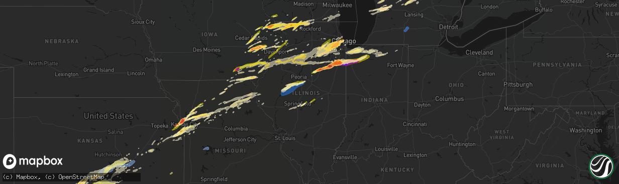
Hail Map in Illinois on March 10, 2026
The weather event in Illinois on March 10, 2026 includes Hail, Tornado, and Wind maps. 11 states and 1,358 cities were impacted and suffered possible damage. The total estimated number of properties impacted is 373,504.
Hail
Tornado
Wind
373,504
Estimated number of impacted properties by a 1.00" hail or larger218,258
Estimated number of impacted properties by a 1.75" hail or larger155,405
Estimated number of impacted properties by a 2.50" hail or largerStorm reports in Illinois
Illinois
| Date | Description |
|---|---|
| 03/10/20266:59 PM CDT | Indiana state police reports tornado on the ground visible from near in-10 and 600 west road. |
| 03/10/20266:58 PM CDT | Corrects previous hail report from princeton. |
| 03/10/20266:57 PM CDT | A local report indicates 2.00 inch wind near 2 SE Woodbine |
| 03/10/20266:54 PM CDT | Multiple reports of a tornado crossing main street on the north side of hopkins park. Relayed via amateur radio. Time estimated by radar. |
| 03/10/20266:50 PM CDT | A local report indicates 1.25 inch wind near 3 N Derinda Center |
| 03/10/20266:44 PM CDT | Multiple reports of hail in momence. The largest hailstones were estimated to be the size of golf balls. |
| 03/10/20266:44 PM CDT | A local report indicates 1.50 inch wind near 1 SE Hanover |
| 03/10/20266:41 PM CDT | Reported at route 17 and sandbar road. |
| 03/10/20266:39 PM CDT | Power lines downed on east 2250 south road south of sun river terrace. Relayed via off duty nws employee. Possible tornado... Time estimated by radar. |
| 03/10/20266:35 PM CDT | A local report indicates 4.10 inch wind near 1 NW Aroma Park |
| 03/10/20266:33 PM CDT | Nickel to quarter sized hail occurring right now. Increasing in intensity. |
| 03/10/20266:32 PM CDT | 3 inch diameter hail reported in kankakee. Relayed via amateur radio. |
| 03/10/20266:31 PM CDT | Videos and photos shared to social media show damage to structures and solar farm near 2000 south road and 3000 east road north of aroma park. Possible tornado. |
| 03/10/20266:31 PM CDT | Photo shared to social media shows softball size hail near beckman park in kankakee. Time estimated by radar. |
| 03/10/20266:30 PM CDT | Photo shows hailstone approximately 6 inches in diameter in southeastern kankakee. Time estimated by radar. |
| 03/10/20266:30 PM CDT | Multiple photos shared to social media show damage to structures and trees near waldron road and marquette lane near aroma park. Possible tornado. Time estimated by rad |
| 03/10/20266:27 PM CDT | Baseball size hail reported on the south side of kankakee. Relayed via social media. Time estimated by radar. |
| 03/10/20266:27 PM CDT | Photo shared to social media shows approximately 4.5 inch diameter hail on the south side of kankakee. Time estimated by radar. |
| 03/10/20266:27 PM CDT | Video shows tornado on the ground near the kankakee airport. |
| 03/10/20266:25 PM CDT | Delayed report. |
| 03/10/20266:24 PM CDT | Kankakee county ema reports tornado touch down near i-57 and justice way. Time estimated by radar. |
| 03/10/20266:23 PM CDT | Roof damaged near west industrial park drive and stuart drive in kankakee. Possible tornado. Time estimated by radar. |
| 03/10/20266:23 PM CDT | Photo shared by storm chaser shows 5.2 inch diameter hail just southwest of kankakee. |
| 03/10/20266:21 PM CDT | A local report indicates 1.00 inch wind near Buda |
| 03/10/20266:20 PM CDT | Hail broke windows in bradley. |
| 03/10/20266:20 PM CDT | Report from mping. |
| 03/10/20266:20 PM CDT | Report from mping. |
| 03/10/20266:20 PM CDT | Public report of hail up to quarter size near humboldt park in chicago. Time estimated by radar. |
| 03/10/20266:17 PM CDT | Nws employee reports hail up to half dollar size in south loop community area of chicago. Time estimated by radar. |
| 03/10/20266:16 PM CDT | Relayed via mping. |
| 03/10/20266:14 PM CDT | Report from mping. |
| 03/10/20266:13 PM CDT | A local report indicates 1.50 inch wind near 1 E Forest Park |
| 03/10/20266:11 PM CDT | Relayed via mping. Time estimated by radar. |
| 03/10/20266:11 PM CDT | A local report indicates 4.50 inch wind near 1 NNE Kankakee |
| 03/10/20266:10 PM CDT | A local report indicates 1.50 inch wind near Berwyn |
| 03/10/20266:10 PM CDT | Photo shared to social media shows 4 inch diameter hail near irwin. Time estimated by radar. |
| 03/10/20266:10 PM CDT | Corrects previous hail report from 3 n irwin. Photo shared to social media shows 4 inch diameter hail near irwin. Time estimated by radar. |
| 03/10/20266:10 PM CDT | Multiple public reports of hail in bourbonnais. The largest hailstones were measured to be 3 inches in diameter. |
| 03/10/20266:08 PM CDT | A local report indicates 1.00 inch wind near 1 NE Countryside |
| 03/10/20266:07 PM CDT | Quarter size hail reported in north riverside. Time estimated by radar. |
| 03/10/20266:06 PM CDT | Largest hailstones estimated to be between 1.5 and 2 inches in diameter. |
| 03/10/20266:04 PM CDT | Relayed via mping. |
| 03/10/20266:04 PM CDT | Report from mping. |
| 03/10/20266:00 PM CDT | Relayed via amateur radio. |
| 03/10/20266:00 PM CDT | Trained spotter reports walnut size hail in brookfield. Hail occurred over 10 minute period from 5:54 pm to 6:05 pm. |
| 03/10/20265:55 PM CDT | Photo shared of hail measuring 3 inches in diameter near intersection of 75th street and interstate 355. |
| 03/10/20265:53 PM CDT | Photo shared on social media showing largest hailstones approximately 4 inches in diameter in westmont. |
| 03/10/20265:53 PM CDT | Public report of baseball size hail in south westmont. |
| 03/10/20265:51 PM CDT | Delayed report via social media. |
| 03/10/20265:51 PM CDT | Multiple reports of baseball size hail in southeast downers grove. |
| 03/10/20265:50 PM CDT | Public report of tennis ball size hail in southwest downers grove. |
| 03/10/20265:48 PM CDT | Report from mping: grapefruit |
| 03/10/20265:47 PM CDT | Photo shared to office email account of hailstone measuring 4.8 inches in diameter near the intersection of 75th street and cass ave in darien. Time estimated by radar. |
| 03/10/20265:47 PM CDT | Trained spotter reports golfball size hail in darien. |
| 03/10/20265:46 PM CDT | Trained spotter reports quarter size hail at i-55 and cass avenue in darien. Time estimated by radar. |
| 03/10/20265:46 PM CDT | Photo shared to social media shows 3.75 inch hail on washington street in darien. Time estimated by radar. |
| 03/10/20265:45 PM CDT | Multiple trained spotter reports of quarter size hail in bonfield. |
| 03/10/20265:45 PM CDT | Relayed via mping. |
| 03/10/20265:44 PM CDT | Photo shared on social media showed hail approximately 1 inch in diameter. |
| 03/10/20265:44 PM CDT | Damage reported to cars and roofs. |
| 03/10/20265:44 PM CDT | Relayed via mping. Time estimated by radar. |
| 03/10/20265:42 PM CDT | Trained spotter reports quarter to half dollar size hail near 75th and main street in downers grove. |
| 03/10/20265:42 PM CDT | A local report indicates 3.25 inch wind near 2 ENE Woodridge |
| 03/10/20265:40 PM CDT | A local report indicates 2.75 inch wind near 1 E Woodridge |
| 03/10/20265:38 PM CDT | Report from mping. |
| 03/10/20265:38 PM CDT | Report from mping. |
| 03/10/20265:37 PM CDT | 3 inch diameter hail in southern woodridge. Relayed via mping. Time estimated by radar. |
| 03/10/20265:37 PM CDT | Relayed via mping. |
| 03/10/20265:36 PM CDT | Trained spotter reports golfball size hail in bolingbrook. |
| 03/10/20265:36 PM CDT | A local report indicates 5.00 inch wind near 2 NNW Buckingham |
| 03/10/20265:36 PM CDT | A local report indicates 2.50 inch wind near 2 NE Bolingbrook |
| 03/10/20265:35 PM CDT | Delayed report. |
| 03/10/20265:34 PM CDT | Relayed via mping. |
| 03/10/20265:34 PM CDT | Photo shows approximately baseball size hail near riddick. Time estimated by radar. Relayed via social media. |
| 03/10/20265:34 PM CDT | Report from mping. |
| 03/10/20265:34 PM CDT | Public report of quarter size hail between buckingham and herscher. Relayed via mping. |
| 03/10/20265:33 PM CDT | Quarter size hail reported near i-55 and il-53. Relayed via mping. |
| 03/10/20265:33 PM CDT | Corrects previous tstm wnd dmg report from 1 sse bolingbrook. Quarter size hail reported near i-55 and il-53. Relayed via mping. |
| 03/10/20265:33 PM CDT | Hail up to tennis ball size in western bolingbrook. Time estimated by radar. |
| 03/10/20265:32 PM CDT | A local report indicates 5.00 inch wind near 3 NE Campus |
| 03/10/20265:32 PM CDT | Photo shared of hail measuring just over 3 inches in diameter in bolingbrook. Time estimated by radar. |
| 03/10/20265:31 PM CDT | A local report indicates 1.75 inch wind near 2 SW Herscher |
| 03/10/20265:31 PM CDT | Public report of hail up to 3.5 inch diameter near village of cardiff northeast of campus. Time estimated by radar. Relayed via social media. |
| 03/10/20265:31 PM CDT | Public report of golf ball size hail in western bolingbrook. Time estimated by radar. |
| 03/10/20265:30 PM CDT | Relayed via mping. Time estimated by radar. |
| 03/10/20265:29 PM CDT | 3 inch hail reported near campus. Relayed via mping. Time estimated by radar. |
| 03/10/20265:27 PM CDT | Hail up to 3 inch diameter reported 3 miles east of campus. Relayed via social media. Time estimated by radar. |
| 03/10/20265:27 PM CDT | Photo relayed by broadcast media of a 5.5 inch diameter hailstone that occurred in campus. |
| 03/10/20265:24 PM CDT | Relayed via mping. |
| 03/10/20265:20 PM CDT | Multiple reports of ping pong size hail in west and northwest plainfield. |
| 03/10/20265:13 PM CDT | Half dollar size hail near 135th and il-59. Relayed via amateur radio. Time estimated by radar. |
| 03/10/20265:11 PM CDT | Nws employee reports 1 inch diameter hail on the west side of plainfield. |
| 03/10/20265:10 PM CDT | Relayed via mping. Time estimated by radar. |
| 03/10/20265:07 PM CDT | Relayed via amateur radio. Time estimated by radar. |
| 03/10/20264:59 PM CDT | Report from mping: grapefruit |
| 03/10/20264:58 PM CDT | Report from mping: quarter |
| 03/10/20264:56 PM CDT | 2 inch diameter hail southeast of odell. Time estimated by radar. Relayed via social media. |
| 03/10/20264:50 PM CDT | Brief tornado touchdown reported north of pontiac by storm chaser. Location estimated by radar. |
| 03/10/20264:50 PM CDT | Garage and dock damaged on 1600 east road just north of pontiac. Possible tornado. Relayed via county dispatch. |
| 03/10/20264:45 PM CDT | Relayed via mping. Time estimated by radar. |
| 03/10/20264:45 PM CDT | A local report indicates 4.00 inch wind near 4 SW Odell |
| 03/10/20264:40 PM CDT | Report of tennis ball size hail near pontiac. Time estimated by radar. Relayed via social media. |
| 03/10/20264:17 PM CDT | Quarter size hail reported in flanagan. Relayed via broadcast media. |
| 03/10/20264:12 PM CDT | Near the intersection of 1800 north and 3100 east. |
| 03/10/202611:58 AM CDT | Delayed public report relayed by broadcast media of a barn damaged. Time estimated by radar. |
| 03/10/20266:31 AM CDT | Power outages in a few locations reported in and just east of fairfield. |
| 03/10/20266:31 AM CDT | Tree blown into a trailer on ash street in fairfield. |
| 03/10/20266:24 AM CDT | Reported from a personal weather station. |
| 03/10/20266:21 AM CDT | Delayed report: two houses have outbuildings with roof damage... Trees snapped... Power lines down... And one grain bin knocked over. Time estimated from radar. |
| 03/10/20266:05 AM CDT | Tree uprooted across the road at old us 50 and fox creek rd. Time estimated by radar. |
| 03/10/20266:00 AM CDT | A local report indicates 60 MPH wind near Xenia |
| 03/10/20266:00 AM CDT | A local report indicates 67 MPH wind near 2 WNW Xenia |
| 03/10/20265:48 AM CDT | Several power outages reported near and east of dix. |
| 03/10/20265:45 AM CDT | Trees down in jefferson county. One of the trees is across hwy 15. |
| 03/10/20265:35 AM CDT | Measured 66 mph wind gust at salem leckrone airport kslo. |
| 03/10/20265:24 AM CDT | Power lines down. Time estimated from radar. |
| 03/10/20265:24 AM CDT | Report relayed by broadcast media of a shed flipped upside down in the middle of the road. Time estimated by radar. |
| 03/10/20265:24 AM CDT | Report relayed by broadcast media of air conditioner units ripped off a building in town. Time estimated by radar. |
| 03/10/20265:24 AM CDT | Multiple smaller trees snapped at their base and a pine tree uprooted. A house has a damaged fence. Time estimated from radar. |
| 03/10/20265:15 AM CDT | Tree down on county highway 6 east of venedy. Time estimated by radar. |
| 03/10/20265:08 AM CDT | Tree limb damaged mobile home. Time estimated by radar. |
| 03/10/20265:08 AM CDT | Home damaged. |
| 03/10/20265:05 AM CDT | 2 power poles broken near the intersection of rt 154 and plum creek rd. |
| 03/10/20265:05 AM CDT | Storm survey confirmed a brief ef-1 tornado with maximum estimated winds of 94 mph... Based on analysis of damage to trees and outbuildings. Total path length of 2.6 mi |
| 03/10/20265:00 AM CDT | 4 inch limbs down from a healthy tree. Time estimated from radar. |
| 03/10/20265:00 AM CDT | Power lines down. Time estimated by radar. |
| 03/10/20265:00 AM CDT | Trees down blocking baldwin rd near new athens il. Time estimated by radar. |
| 03/10/20264:44 AM CDT | Large tree down on garage relayed by broadcast media. Time estimated from radar. |
| 03/10/20264:44 AM CDT | Report of a fence destroyed relayed by broadcast media. Time estimated via radar. |
| 03/10/20264:26 AM CDT | Damage to an old barn... Car... And what looks to be sheet metal from a roof or outbuilding. Time estimated from radar. |
| 03/10/20264:08 AM CDT | Brief weak ef0 tornado knocked down power poles and damaged a solar farm. |
| 03/10/20264:08 AM CDT | Significant damage to a solar farm and shipping crates... 2000 without power. Time estimated from radar. |
| 03/10/20263:54 AM CDT | 67 mph wind gust reported at alton regional airport. |
| 03/10/20263:50 AM CDT | *** 1 inj *** survey crews confirmed a brief ef-1 tornado that did damage within the communities of moro and midway... Il... Early this morning along a 1.6 mile path. |
| 03/10/20263:50 AM CDT | Damage to grain bins. |
| 03/10/20263:50 AM CDT | *** 1 inj *** corrects previous tstm wnd dmg report from 3 ene bethalto. Roof off home... Tree limbs broken... Damage to outbuilding. |
| 03/10/20263:24 AM CDT | Significant roof damage to a local restaurant. Time estimated from radar. |
| 03/10/20263:24 AM CDT | Corrects previous tstm wnd dmg report from 1 w grafton. Significant roof damage to a local restaurant. Time estimated from radar. |
| 03/10/20261:55 AM CDT | A local report indicates 1.50 inch wind near 2 S Forsyth |
| 03/10/20261:47 AM CDT | Power lines down on florida court. Time estimated by radar. |
| 03/10/202612:30 AM CDT | A local report indicates 1.00 inch wind near 1 ENE Tremont |
| 03/10/202612:28 AM CDT | A local report indicates 1.25 inch wind near Tremont |
| 03/10/202612:22 AM CDT | Part of a large tree was blown down onto a garage. |
| 03/10/202612:20 AM CDT | A street lamp pole was blown down. |
| 03/10/202612:16 AM CDT | Power poles were snapped near the intersection of toboggan avenue and chapel road. |
| 03/09/202611:58 PM CDT | Corrects previous tornado report from 1 wnw topeka. Delayed public report relayed by broadcast media of a barn damaged. Time estimated by radar. |
| 03/09/202611:47 PM CDT | Power lines were blown down along us-136 east of havana. |
| 03/09/202611:47 PM CDT | A few trees... Power lines... And traffic lights were blown down. |
| 03/09/202610:29 PM CDT | Hail up to quarter size on the south side of yorkville. |
| 03/09/202610:25 PM CDT | A local report indicates 1.00 inch wind near Grant Park |
| 03/09/20268:59 PM CDT | A local report indicates 1.00 inch wind near 1 SSW Cambridge |
| 03/09/20268:42 PM CDT | Nickel to quarters. |
| 03/09/20268:27 PM CDT | A local report indicates 1.00 inch wind near 1 NW Lake Summerset |
| 03/09/20268:22 PM CDT | A local report indicates 1.00 inch wind near 1 S Mc Nabb |
| 03/09/20267:54 PM CDT | Delayed report. |
| 03/09/20267:52 PM CDT | Delayed report. |
| 03/09/20267:50 PM CDT | Time estimated by radar. |
| 03/09/20267:43 PM CDT | Trained spotter reports quarter size hail near ben street and charles street. Time estimated by radar. |
| 03/09/20267:36 PM CDT | Report from mping: quarter |
| 03/09/20267:35 PM CDT | Report from mping: quarter |
| 03/09/20267:33 PM CDT | Report from mping: half dollar |
| 03/09/20267:32 PM CDT | Time estimated. |
| 03/09/20267:32 PM CDT | Photo shared on social media showing 1 inch diameter hail. |
| 03/09/20267:27 PM CDT | A local report indicates 1.75 inch wind near 3 SW Mc Connell |
| 03/09/20267:27 PM CDT | A local report indicates 1.25 inch wind near 2 WSW Damascus |
| 03/09/20267:27 PM CDT | A local report indicates 1.00 inch wind near 1 SW Lena |
| 03/09/20267:25 PM CDT | Delayed report via social media. |
| 03/09/20267:25 PM CDT | Report from mping: quarter |
| 03/09/20267:22 PM CDT | Report from mping: quarter |
| 03/09/20267:22 PM CDT | Delayed report. Shipping container type storage building flipped onto its side. Time estimated by radar. |
| 03/09/20267:22 PM CDT | Delayed report. Steel post in a concrete setting ripped out of the ground. Time estimated by radar. |
| 03/09/20267:19 PM CDT | Report from mping: quarter |
| 03/09/20267:18 PM CDT | Time estimated by radar. |
| 03/09/20267:18 PM CDT | Multiple power lines were blown down... A carport was snapped... And a shipping container was flipped into a house north of the il-180 and il-167 intersection. |
| 03/09/20267:14 PM CDT | A local report indicates 2.75 inch wind near 3 W Lena |
| 03/09/20267:10 PM CDT | A local report indicates 1.00 inch wind near Fulton |
| 03/09/20267:07 PM CDT | A local report indicates 2.25 inch wind near Princeton |
| 03/09/20267:06 PM CDT | A local report indicates 1.00 inch wind near Albany |
All States Impacted by Hail Map on March 10, 2026
Cities Impacted by Hail Map on March 10, 2026
- Dryden, TX
- Shattuck, OK
- Sheffield, TX
- Ozona, TX
- Higgins, TX
- Canadian, TX
- Wingate, TX
- Flanagan, IL
- El Paso, IL
- Minonk, IL
- Graymont, IL
- Pontiac, IL
- Tuscola, TX
- Gridley, IL
- Marseilles, IL
- Ovalo, TX
- Buffalo Gap, TX
- Abilene, TX
- Odell, IL
- Fargo, OK
- Buffalo, OK
- Morris, IL
- Seneca, IL
- Newark, IL
- Del Rio, TX
- May, OK
- Follett, TX
- Booker, TX
- Minooka, IL
- Yorkville, IL
- Trent, TX
- Merkel, TX
- Hawley, TX
- Anson, TX
- Clyde, TX
- Lueders, TX
- Avoca, TX
- Stamford, TX
- Freedom, OK
- Joliet, IL
- Plainfield, IL
- Shorewood, IL
- Oswego, IL
- Kempton, IL
- Emington, IL
- Cabery, IL
- Mertzon, TX
- Comstock, TX
- San Angelo, TX
- Buckingham, IL
- Reddick, IL
- Dwight, IL
- Campus, IL
- Lemont, IL
- Lockport, IL
- Romeoville, IL
- Crest Hill, IL
- Bolingbrook, IL
- Woodridge, IL
- Naperville, IL
- Norton, TX
- Baird, TX
- Eldorado, TX
- Brackettville, TX
- Haskell, TX
- Winters, TX
- Balko, OK
- Herscher, IL
- Alva, OK
- Laughlin Afb, TX
- Downers Grove, IL
- Willowbrook, IL
- Darien, IL
- Westmont, IL
- Coldwater, KS
- Hinsdale, IL
- Clarendon Hills, IL
- Laverne, OK
- Bronte, TX
- Gracemont, OK
- Anadarko, OK
- Oak Brook, IL
- Bonfield, IL
- Union Hill, IL
- Lake City, KS
- Weinert, TX
- Grandfield, OK
- Kankakee, IL
- Moran, TX
- Binger, OK
- Sonora, TX
- Lawn, TX
- Willow Springs, IL
- La Grange, IL
- Western Springs, IL
- Seaton, IL
- Mediapolis, IA
- Oakville, IA
- Hickory Hills, IL
- Justice, IL
- Devol, OK
- Medicine Lodge, KS
- Hillside, IL
- Westchester, IL
- La Grange Park, IL
- Brookfield, IL
- Broadview, IL
- Lyons, IL
- Bourbonnais, IL
- Summit Argo, IL
- Hines, IL
- Maywood, IL
- Forest Park, IL
- Riverside, IL
- Cicero, IL
- Berwyn, IL
- Chicago, IL
- Bradley, IL
- Toulon, IL
- Neponset, IL
- Minco, OK
- Agency, IA
- Eldon, IA
- Ottumwa, IA
- Keithsburg, IL
- Randlett, OK
- West Burlington, IA
- Danville, IA
- Burlington, IA
- Aledo, IL
- Alexis, IL
- Bloomfield, IA
- Middletown, IA
- Sperry, IA
- Goree, TX
- Seymour, TX
- Throckmorton, TX
- Woodhull, IL
- Cambridge, IL
- Altona, IL
- Eudora, KS
- Baldwin City, KS
- Walters, OK
- Hinton, OK
- Calumet, OK
- Bridgeview, IL
- El Reno, OK
- Oak Park, IL
- River Forest, IL
- Bellwood, IL
- Momence, IL
- Union City, OK
- Okarche, OK
- Kingfisher, OK
- Lockridge, IA
- Fairfield, IA
- Kansas City, MO
- Batavia, IA
- Kewanee, IL
- Galva, IL
- Kansas City, KS
- De Soto, KS
- Joy, IL
- Little York, IL
- Saint Anne, IL
- Buda, IL
- New Windsor, IL
- Viola, IL
- Uvalde, TX
- Barksdale, TX
- Rocksprings, TX
- Bonner Springs, KS
- Linwood, KS
- Bradford, IL
- Cisco, TX
- Breckenridge, TX
- Aroma Park, IL
- Yukon, OK
- Dover, OK
- Hennessey, OK
- Grant Park, IL
- Manteno, IL
- Sharon, KS
- Camp Wood, TX
- Rio Frio, TX
- Leakey, TX
- Mustang, OK
- Oquawka, IL
- Princeton, IL
- Tiskilwa, IL
- Wyanet, IL
- Shawnee, KS
- Riverside, MO
- Coggon, IA
- Monticello, IA
- Alpha, IL
- Ophiem, IL
- Libertyville, IA
- Lynn Center, IL
- Electra, TX
- Central City, IA
- Annawan, IL
- Sheffield, IL
- Albany, TX
- Holt, MO
- Temple, OK
- Lawton, OK
- Oklahoma City, OK
- Reynolds, IL
- Illinois City, IL
- Taylor Ridge, IL
- Andalusia, IL
- Milan, IL
- Davenport, IA
- Buffalo, IA
- Blue Grass, IA
- Moline, IL
- Rock Island, IL
- Bettendorf, IA
- Le Claire, IA
- Pleasant Valley, IA
- Eldridge, IA
- Princeton, IA
- Cordova, IL
- Albany, IL
- Rio, IL
- Isabel, KS
- Wilmore, KS
- Attica, KS
- Brighton, IA
- North Henderson, IL
- Caddo, TX
- Zenda, KS
- Nashville, KS
- West Olive, MI
- Zeeland, MI
- Holland, MI
- Mineral, IL
- Lawson, MO
- Lathrop, MO
- Polo, MO
- Amana, IA
- Oxford, IA
- Iowa City, IA
- North Liberty, IA
- Tiffin, IA
- Oneida, IL
- Schneider, IN
- Lake Village, IN
- Lowell, IN
- Ottawa, IL
- Elizabeth, IL
- Hanover, IL
- Mount Pleasant, IA
- Wayland, IA
- Bethany, OK
- Kalona, IA
- Wellman, IA
- Liberty, MO
- Kearney, MO
- Camanche, IA
- Pembroke Township, IL
- Morocco, IN
- Comanche, OK
- Marlow, OK
- Duncan, OK
- Oklaunion, TX
- Harrold, TX
- Davidson, OK
- Swisher, IA
- Fairfax, IA
- Cedar Rapids, IA
- Ely, IA
- Marion, IA
- Mount Vernon, IA
- Springville, IA
- Riverside, IA
- Columbus Junction, IA
- Spivey, KS
- Sheridan, IL
- Sandwich, IL
- Zwingle, IA
- Dubuque, IA
- Stockton, IL
- Wedron, IL
- Serena, IL
- Winfield, IA
- Eden, TX
- Hudsonville, MI
- Jenison, MI
- Cascade, IA
- Bernard, IA
- Frederick, OK
- Peosta, IA
- Kingston, MO
- Hamilton, MO
- Concan, TX
- Coralville, IA
- Solon, IA
- Malden, IL
- Dover, IL
- Kent, IL
- Ranger, TX
- Demotte, IN
- Olds, IA
- Bishop Hill, IL
- Arlington, IL
- West Brooklyn, IL
- Utica, IL
- West Branch, IA
- West Liberty, IA
- Edmond, OK
- Jones, OK
- Spencer, OK
- Atalissa, IA
- Tipton, IA
- Plano, IL
- Paint Rock, TX
- La Motte, IA
- Peru, IL
- Mendota, IL
- Lena, IL
- Morning Sun, IA
- Harper, KS
- Letts, IA
- Wapello, IA
- Utopia, TX
- Anamosa, IA
- Elgin, OK
- Freeport, IL
- Floris, IA
- Selma, IA
- Kingman, KS
- Vanderpool, TX
- Grand Rapids, MI
- Menard, TX
- La Salle, IL
- Shelby, IN
- Hebron, IN
- Thayer, IN
- Prairieburg, IA
- Smithville, MO
- Strawn, TX
- Spring Valley, IL
- Cherry, IL
- Bison, OK
- Mount Union, IA
- Depue, IL
- Atkinson, IL
- La Moille, IL
- Troy Grove, IL
- Erie, IL
- Fulton, IL
- Clinton, IA
- Bristol, IL
- Sugar Grove, IL
- Big Rock, IL
- Aurora, IL
- Montgomery, IL
- Cheney, KS
- Elburn, IL
- North Aurora, IL
- Batavia, IL
- Geneva, IL
- Mooseheart, IL
- Warrenville, IL
- West Chicago, IL
- Norwich, KS
- Murdock, KS
- Excelsior Springs, MO
- Saint Charles, IL
- Breckenridge, MO
- Graford, TX
- Rayville, MO
- Chillicothe, MO
- Galena, IL
- Bellevue, IA
- Medina, TX
- Durand, IL
- McConnell, IL
- Dakota, IL
- Rock City, IL
- Davis, IL
- Leland, IL
- Glenwood, MO
- Lancaster, MO
- Downing, MO
- Grandview, IA
- New Boston, IL
- Macatawa, MI
- East Dubuque, IL
- Wheatfield, IN
- Douds, IA
- Choctaw, OK
- Lisbon, IA
- Vernon, TX
- Wyoming, IL
- Graham, TX
- Coleman, TX
- Seatonville, IL
- Ladd, IL
- Triumph, IL
- La Fayette, IL
- Dalzell, IL
- Birmingham, IA
- Earlville, IL
- Chula, MO
- Somonauk, IL
- Richmond, MO
- Fair Oaks, IN
- Rensselaer, IN
- San Pierre, IN
- Kouts, IN
- La Crosse, IN
- Garden Plain, KS
- Goddard, KS
- Hardin, MO
- Gallatin, MO
- Luther, OK
- Harrah, OK
- Wellston, OK
- Andale, KS
- Mount Hope, KS
- Union Grove, WI
- Twin Lakes, WI
- Burlington, WI
- Memphis, MO
- Beloit, WI
- Nocona, TX
- Sawyer, KS
- Cyril, OK
- Bennett, IA
- Wilton, IA
- Moscow, IA
- Rockton, IL
- Scales Mound, IL
- Santa Anna, TX
- Genoa City, WI
- Wheeling, MO
- Linneus, MO
- Browning, MO
- Purdin, MO
- Orrick, MO
- Mechanicsville, IA
- Pulaski, IA
- Bangs, TX
- Brownwood, TX
- Fletcher, OK
- Henry, IL
- Putnam, IL
- Palo Pinto, TX
- Cedarville, IL
- Brodhead, WI
- Milan, MO
- Milton, KS
- Rush Springs, OK
- Lindsay, OK
- Colwich, KS
- Wichita, KS
- Norborne, MO
- Bristol, WI
- Kansasville, WI
- Sturtevant, WI
- Salem, WI
- Kenosha, WI
- Pearl City, IL
- Kerrville, TX
- Bandera, TX
- Center Point, TX
- Melvin, TX
- Jacksboro, TX
- Mineral Wells, TX
- Milton, IA
- Cantril, IA
- Gordon, TX
- Green Castle, MO
- Green City, MO
- Farley, IA
- Epworth, IA
- Lake Geneva, WI
- McNabb, IL
- Hennepin, IL
- Magnolia, IL
- Geneseo, IL
- Coatsville, MO
- Shirland, IL
- Winnebago, IL
- Warren, IL
- Wyoming, MI
- Kiowa, KS
- Valley Center, KS
- Worthington, IA
- Sparland, IL
- Lone Tree, IA
- Novinger, MO
- North Judson, IN
- Hanna, IN
- Wanatah, IN
- Maize, KS
- Chandler, OK
- Carrollton, MO
- Grandville, MI
- Prophetstown, IL
- Burlington, OK
- Comfort, TX
- Racine, WI
- Perrin, TX
- Mount Sterling, IA
- Arbela, MO
- Orangeville, IL
- Apple River, IL
- Muir, MI
- Ionia, MI
- Weatherford, TX
- Whitt, TX
- Argonia, KS
- Hazelton, KS
- Brookfield, MO
- Salem, IA
- Stockport, IA
- Lostant, IL
- Lacon, IL
- Varna, IL
- Millsap, TX
- Shannon, IL
- Bureau, IL
- Millington, IL
- Millbrook, IL
- Knox, IN
- Sedgwick, KS
- Greentop, MO
- Queen City, MO
- Kechi, KS
- Greenwich, KS
- Benton, KS
- Plymouth, IN
- Hamlet, IN
- Grovertown, IN
- Lenexa, KS
- Basehor, KS
- Olathe, KS
- De Leon, TX
- Comanche, TX
- Waldron, KS
- Winslow, IL
- Conway Springs, KS
- Poolville, TX
- Bridgeport, TX
- Bonaparte, IA
- Farmington, IA
- Luray, MO
- Kahoka, MO
- Newton, KS
- Whitewater, KS
- Dublin, TX
- Streator, IL
- Tonica, IL
- Anthony, KS
- Amorita, OK
- Bucklin, MO
- Hubbardston, MI
- Fowler, MI
- Pewamo, MI
- Keosauqua, IA
- Tampico, IL
- Burns, KS
- Ethel, MO
- Fredericksburg, TX
- Sherrard, IL
- Pocasset, OK
- Springtown, TX
- Stillwater, OK
- Mulhall, OK
- Bogard, MO
- Walkerton, IN
- Augusta, KS
- Andover, KS
- El Dorado, KS
- Towanda, KS
- Bluff City, KS
- Caldwell, KS
- Carmen, OK
- Cherokee, OK
- Durant, IA
- Walcott, IA
- Stockton, IA
- Chico, TX
- Lisle, IL
- Paradise, TX
- Perrinton, MI
- Potwin, KS
- Quenemo, KS
- Bosworth, MO
- Manchester, OK
- Donnellson, IA
- Mendon, MO
- Waverly, KS
- Melvern, KS
- Wellsville, KS
- Pecatonica, IL
- Rockford, IL
- Saint Johns, MI
- Danville, KS
- Leonore, IL
- Ada, MI
- New Cambria, MO
- Deer Grove, IL
- Spring Hill, KS
- Edgerton, KS
- Viola, KS
- Clearwater, KS
- Lebo, KS
- Cottonwood Falls, KS
- Cassoday, KS
- Callao, MO
- Elmer, MO
- Stephenville, TX
- Cedar Point, KS
- Wakita, OK
- Helena, OK
- Freeport, KS
- Overland Park, KS
- Pompeii, MI
- Ashley, MI
- Carson City, MI
- Maple Rapids, MI
- Middleton, MI
- Medford, OK
- Azle, TX
- Dixon, IA
- Donahue, IA
- Pomona, KS
- Marceline, MO
- Bevier, MO
- Atlanta, MO
- Novelty, MO
- La Plata, MO
- Davenport, OK
- Sparks, OK
- Meeker, OK
- Gardner, KS
- Potosi, WI
- Ottawa, KS
- Millersview, TX
- Long Grove, IA
- Jet, OK
- Peck, KS
- Fruitport, MI
- Nunica, MI
- Triplett, MO
- Decatur, TX
- Haysville, KS
- Alvord, TX
- Grand Ridge, IL
- Leon, KS
- Mcconnell Afb, KS
- Ithaca, MI
- Boyd, TX
- West Point, IA
- Stroud, OK
- Lohn, TX
- Ravenna, MI
- Coopersville, MI
- Reading, KS
- Emporia, KS
- Neosho Rapids, KS
- Eureka, KS
- Mulvane, KS
- Conklin, MI
- Independence, MO
- Camden, MO
- Lyndon, KS
- Salisbury, MO
- Leawood, KS
- Nash, OK
- North Liberty, IN
- Homer Glen, IL
- Burbank, IL
- Ransom, IL
- Elsie, MI
- Wellington, KS
- Derby, KS
- Doole, TX
- Leonard, MO
- Rose Hill, KS
- Belle Plaine, KS
- Rhome, TX
- Krum, TX
- Ponder, TX
- Essex, IL
- Bannister, MI
- Lewistown, MO
- La Belle, MO
- Knox City, MO
- Osage City, KS
- Sanger, TX
- Junction, TX
- South Haven, KS
- Madison, KS
- Mayfield, KS
- Darlington, WI
- De Witt, IA
- Macon, MO
- Kinsman, IL
- Orleans, MI
- Greenville, MI
- Casnovia, MI
- Gardner, IL
- Anabel, MO
- Rothville, MO
- Oakley, MI
- Henderson, MI
- Chesaning, MI
- Verona, IL
- Brady, TX
- Era, TX
- Gainesville, TX
- Valley View, TX
- Muenster, TX
- Lindsay, TX
- Whitesboro, TX
- Thackerville, OK
- Marietta, OK
- Sadler, TX
- Rosston, TX
- Lebanon, OK
- Overbrook, OK
- Ardmore, OK
- Kingston, OK
- Burneyville, OK
- Madill, OK
- Gordonville, TX
- Pottsboro, TX
- Braceville, IL
- New London, IA
- Wilmington, IL
- Brant, MI
- Sheridan, MI
- Fenwick, MI
- Hartford, KS
- Clarence, MO
- Excello, MO
- Granville, IL
- Amboy, IL
- Monticello, MO
- Canton, MO
- La Grange, MO
- Rock, KS
- Saint Charles, MI
- Prairie Village, KS
- Stilwell, KS
- Douglass, KS
- Dyer, IN
- Newark, MO
- Shelbyville, MO
- Bethel, MO
- Udall, KS
- Kent City, MI
- Mannsville, OK
- Atlanta, KS
- London, TX
- Paola, KS
- Schererville, IN
- Griffith, IN
- Crown Point, IN
- Merrillville, IN
- Saint John, IN
- Gary, IN
- Highland, IN
- Gridley, KS
- Burlington, KS
- Depew, OK
- Bristow, OK
- Seminole, OK
- Lentner, MO
- Warsaw, IL
- Stanton, MI
- Mansfield, TX
- Prague, OK
- Shawnee, OK
- Mark, IL
- Yarmouth, IA
- Bucyrus, KS
- Lees Summit, MO
- Blue Springs, MO
- Mead, OK
- Durant, OK
- Grain Valley, MO
- Oak Grove, MO
- Lake Station, IN
- Hobart, IN
- Valparaiso, IN
- Chesterton, IN
- Portage, IN
- Grandview, MO
- Philadelphia, MO
- Durham, MO
- Emden, MO
- Ewing, MO
- Latham, KS
- Wheaton, IL
- Oglesby, IL
- Crystal, MI
- Savanna, IL
- Belton, MO
- Hale, MO
- Westville, IN
- La Porte, IN
- Michigan City, IN
- Piedmont, KS
- Bates City, MO
- Napoleon, MO
- Buckner, MO
- Ursa, IL
- Maywood, MO
- Wellington, MO
- Lexington, MO
- Mendon, IL
- Union Mills, IN
- Quincy, IL
- Fowler, IL
- Paloma, IL
- Rantoul, KS
- Osawatomie, KS
- Dover, MO
- Brunswick, MO
- Odessa, MO
- Bixby, OK
- Burt, MI
- Broken Arrow, OK
- Coweta, OK
- Inola, OK
- Hopkinton, IA
- Manhattan, IL
- Elwood, IL
- Pontotoc, TX
- Oak Lawn, IL
- Palos Park, IL
- Lone Jack, MO
- Raymore, MO
- Greenwood, MO
- Tarpley, TX
- Chouteau, OK
- Pryor, OK
- Claremore, OK
- Pipe Creek, TX
- Boerne, TX
- Adair, OK
- Locust Grove, OK
- Llano, TX
- Lampasas, TX
- Buchanan Dam, TX
- Tow, TX
- Burnet, TX
- Bluffton, TX
- Kingsland, TX
- Salina, OK
- Browning, IL
- Bath, IL
- Beardstown, IL
- Lometa, TX
- San Saba, TX
- Cherokee, TX
- Bend, TX
- Valley Spring, TX
- Strang, OK
- Big Cabin, OK
- Vinita, OK
- South Bend, IN
- Kingsford Heights, IN
- Lakeville, IN
- Waverly, MO
- Frankfort, IL
- Ipava, IL
- Astoria, IL
- Pleasant Hill, MO
- Hillsboro, IA
- Goldthwaite, TX
- Bennington, OK
- Boswell, OK
- Alma, MO
- Lewistown, IL
- Canton, IL
- De Witt, MO
- Malta Bend, MO
- Ohio, IL
- Keytesville, MO
- Chandlerville, IL
- Kilbourne, IL
- Topeka, IL
- Easton, IL
- Havana, IL
- Eucha, OK
- Spavinaw, OK
- Rose, OK
- Kempner, TX
- Marble Falls, TX
- Marshall, MI
- Homer, MI
- Manito, IL
- Forest City, IL
- San Jose, IL
- Green Valley, IL
- Mason City, IL
- Jay, OK
- Colcord, OK
- Fort Hood, TX
- Copperas Cove, TX
- Killeen, TX
- Albion, MI
- Delavan, IL
- Miami, MO
- Parsons, KS
- Bremen, IN
- Nappanee, IN
- Wakarusa, IN
- Mishawaka, IN
- Dalton, MO
- Liverpool, IL
- Hamilton, TX
- Evant, TX
- Clifton Hill, MO
- Hugo, OK
- Grant, OK
- Saint Paul, KS
- Nolan, TX
- Deepwater, MO
- Clinton, MO
- Wilburton, OK
- Talihina, OK
- Red Oak, OK
- Tremont, IL
- Mackinaw, IL
- Hopedale, IL
- Minier, IL
- Warsaw, MO
- Maple Park, IL
- Goose Lake, IA
- Bryant, IA
- Onslow, IA
- Preston, IA
- Fort Madison, IA
- Cornell, IL
- Villa Park, IL
- Glen Ellyn, IL
- Lombard, IL
- Palos Hills, IL
- Mokena, IL
- New Lenox, IL
- Mazon, IL
- Pekin, IL
- Comstock Park, MI
- Juda, WI
- Allendale, MI
- Cleveland, MO
- Louisburg, KS
- Fenton, IL
- Morrison, IL
- Goshen, IN
- Wasco, IL
- Tryon, OK
- Milford, IN
- South Wilmington, IL
- Maquoketa, IA
- Delmar, IA
- Moberly, MO
- Cairo, MO
- Bryson, TX
- Madison, MO
- Shelbina, MO
- Marne, MI
- Williams Bay, WI
- Fontana, WI
- Browntown, WI
- Monroe, WI
- South Wayne, WI
- Kirksville, MO
- Belding, MI
- Silver Lake, WI
- Charlotte, IA
- Baileyville, IL
- Dawn, MO
- Monee, IL
- Belmont, MI
- Lincolnwood, IL
- Evanston, IL
- Bourbon, IN
- Tinley Park, IL
- Oak Forest, IL
- Braymer, MO
- Martelle, IA
- New Paris, IN
- Carney, OK
- Bensenville, IL
- Melrose Park, IL
- Franklin Park, IL
- Elmhurst, IL
- Ridott, IL
- Eastland, TX
- Ligonier, IN
- Millersburg, IN
- Homestead, IA
- Middle Amana, IA
- Baldwin, IA
- McCune, KS
- Girard, KS
- Des Plaines, IL
- River Grove, IL
- Elmwood Park, IL
- Schiller Park, IL
- Harwood Heights, IL
- Clinton, WI
- New Vienna, IA
- Sublette, IL
- South Beloit, IL
- Roscoe, IL
- Conesville, IA
- Durango, IA
- Holy Cross, IA
- Welton, IA
- Chicago Ridge, IL
- Berkeley, IL
- Chicago Heights, IL
- Etna Green, IN
- South Pekin, IL
- Peculiar, MO
- Payson, IL
- Hull, IL
- Emden, IL
- Plainville, IL
- Syracuse, IN
- Hunt, TX
- Munday, TX
- Shady Point, OK
- Wister, OK
- Bokoshe, OK
- Spiro, OK
- Cameron, OK
- Wolcottville, IN
- Chester, AR
- Cedarville, AR
- Rudy, AR
- Liberty, IL
- Rochester, IL
- Pocola, OK
- Fort Smith, AR
- Mt Zion, IL
- Decatur, IL
- Macon, IL
- Springfield, IL
- Chatham, IL
- Edinburg, IL
- Mechanicsburg, IL
- Buffalo, IL
- Illiopolis, IL
- Waverly, IL
- Loami, IL
- Dalton City, IL
- Mountainburg, AR
- Bement, IL
- Harristown, IL
- Forsyth, IL
- Oreana, IL
- Elkins, AR
- Combs, AR
- Huntsville, AR
- Witter, AR
- Saint Paul, AR
- Wesley, AR
- Pettigrew, AR
- Kingston, AR
- Berryville, AR
- Ponca, AR
- Compton, AR
- Green Forest, AR
- Alpena, AR
- Harrison, AR
- Mulberry, AR
- Ozark, AR
- Oark, AR
- Alma, AR
- Lavaca, AR
- Van Buren, AR
- Dyer, AR
- Charleston, AR
- Barling, AR
- Cecil, AR
- Montgomery City, MO
- New Florence, MO
- High Hill, MO
- Jonesburg, MO
- Platteville, WI
- Golden Eagle, IL
- Saint Charles, MO
- Brussels, IL
- Grafton, IL
- Portage Des Sioux, MO
- Maroa, IL
- Warrensburg, IL
- Niantic, IL
- Blue Mound, IL
- Hammond, IL
- Cerro Gordo, IL
- Argenta, IL
- Mount Auburn, IL
- Glenarm, IL
- Auburn, IL
- Hartford, IL
- East Alton, IL
- Wood River, IL
- Roxana, IL
- Bethalto, IL
- Cottage Hills, IL
- Moro, IL
- South Roxana, IL
- Edwardsville, IL
- Worden, IL
- Hamel, IL
- Alhambra, IL
- Highland, IL
- Pocahontas, IL
- Walshville, IL
- Sorento, IL
- Livingston, IL
- New Douglas, IL
- Staunton, IL
- Dorsey, IL
- Boody, IL
- Skokie, IL
- Morton Grove, IL
- Stone Park, IL
- Elk Grove Village, IL
- Lenzburg, IL
- Marissa, IL
- New Athens, IL
- Saint Libory, IL
- Okawville, IL
- Addieville, IL
- Oakdale, IL
- Coulterville, IL
- Nashville, IL
- Centralia, IL
- Odin, IL
- Sandoval, IL
- Salem, IL
- Alma, IL
- Kinmundy, IL
- Iuka, IL
- Farina, IL
- Xenia, IL
- Walnut Hill, IL
- Dix, IL
- Kell, IL
- Ashley, IL
- Mount Erie, IL
- Mill Shoals, IL
- Newton, IL
- Dahlgren, IL
- Bonnie, IL
- Ellery, IL
- Tamaroa, IL
- Irvington, IL
- Mount Vernon, IL
- Edgewood, IL
- Du Quoin, IL
- Texico, IL
- Hoyleton, IL
- Willow Hill, IL
- Mason, IL
- Casey, IL
- Dundas, IL
- Opdyke, IL
- Scheller, IL
- Steeleville, IL
- Evansville, IL
- Rinard, IL
- Noble, IL
- Richview, IL
- West Liberty, IL
- Dieterich, IL
- Greenup, IL
- Keenes, IL
- Johnsonville, IL
- Yale, IL
- Wayne City, IL
- Golden Gate, IL
- Tilden, IL
- Waltonville, IL
- Ingraham, IL
- Baldwin, IL
- Cisne, IL
- Sparta, IL
- Geff, IL
- Percy, IL
- Fairfield, IL
- Cutler, IL
- West Salem, IL
- Sims, IL
- Campbell Hill, IL
- Burnt Prairie, IL
- Belle Rive, IL
- Wheeler, IL
- Louisville, IL
- Hidalgo, IL
- Woodlawn, IL
- Flora, IL
- Olney, IL
- Chester, IL
- Du Bois, IL
- Clay City, IL
- Walsh, IL
- Albion, IL
- Sailor Springs, IL
- Bluford, IL
- Barnhill, IL
- Pinckneyville, IL
- Ellis Grove, IL
- Corrigan, TX
- Jewett, IL
- West Union, IL
- Palestine, IL
- Martinsville, IL
- Sainte Marie, IL
- Hutsonville, IL
- Bridgeport, IL
- Flat Rock, IL
- West York, IL
- Oblong, IL
- Stoy, IL
- Annapolis, IL
- Marshall, IL
- Sumner, IL
- Robinson, IL
- Claremont, IL
- Thornton, AR
- Fordyce, AR
- Bearden, AR
- Janesville, WI
- Darien, WI
- Diboll, TX
- Kingsville, MO
- Higginsville, MO
- Brook, IN
- Apache, OK
- Cement, OK
- Argos, IN
- Albion, IN
- Orland, IN
- South Milford, IN
- Hudson, IN
- Corunna, IN
- Howe, IN
- North Webster, IN
- Pleasant Lake, IN
- Shipshewana, IN
- Hamilton, IN
- Leesburg, IN
- Warsaw, IN
- Kendallville, IN
- Ashley, IN
- Waterloo, IN
- Wawaka, IN
- Topeka, IN
- Rome City, IN
- Lagrange, IN
- Cromwell, IN
- Kimmell, IN
- Pierceton, IN
- Angola, IN
- Fremont, IN
- Larwill, IN
- Victoria, IL
- Speer, IL
- Williamsfield, IL
- Gladstone, IL
- Stronghurst, IL
- Wever, IA
- Denmark, IA
- Carman, IL
- Saint Mary, MO
- Leadwood, MO
- Belgrade, MO
- Bonne Terre, MO
- De Soto, MO
- Mineral Point, MO
- Bloomsdale, MO
- Irondale, MO
- Prairie Du Rocher, IL
- Fults, IL
- Modoc, IL
- Farmington, MO
- Valles Mines, MO
- Doe Run, MO
- Red Bud, IL
- Ironton, MO
- Bismarck, MO
- Park Hills, MO
- Potosi, MO
- Festus, MO
- Belleview, MO
- Sainte Genevieve, MO
- French Village, MO
- Caledonia, MO
- Cowgill, MO
- Missouri City, MO
- Garnett, KS
- Westphalia, KS
- Colony, KS
- Richmond, KS
- Welda, KS
- Moran, KS
- Greeley, KS
- Kincaid, KS
- Bronson, KS
- Mound City, KS
- Fontana, KS
- Centerville, KS
- Mapleton, KS
- Blue Mound, KS
- Lane, KS
- La Cygne, KS
- Parker, KS
- Le Roy, KS
- Lowry City, MO
- Collins, MO
- Schell City, MO
- Weaubleau, MO
- El Dorado Springs, MO
- Hermitage, MO
- Quincy, MO
- Rockville, MO
- Montrose, MO
- Butler, MO
- Osceola, MO
- Harwood, MO
- Wheatland, MO
- Appleton City, MO
- Rich Hill, MO
- Walker, MO
- Richards, MO
- Nevada, MO
- Stover, MO
- Preston, MO
- Macks Creek, MO
- Climax Springs, MO
- Edwards, MO
- Gravois Mills, MO
- Roach, MO
- Cross Timbers, MO
- Lincoln, MO
- Valliant, OK
- Garvin, OK
- Idabel, OK
- Broken Bow, OK
- Eagletown, OK
- De Queen, AR
- Gillham, AR
- Crosby, MS


