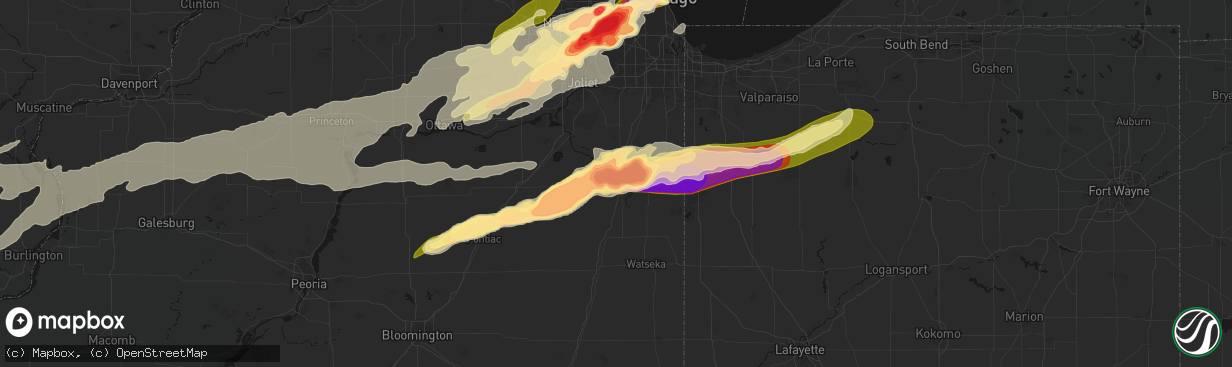
Hail Map in Kankakee, IL on March 10, 2026
The weather event in Kankakee, IL on March 10, 2026 includes Hail, Tornado, and Wind maps. 11 states and 1,358 cities were impacted and suffered possible damage. The total estimated number of properties impacted is 13,824.
Hail
Tornado
Wind
13,824
Estimated number of impacted properties by a 1.00" hail or larger13,669
Estimated number of impacted properties by a 1.75" hail or larger13,561
Estimated number of impacted properties by a 2.50" hail or largerStorm reports in Kankakee, IL
Kankakee, IL
| Date | Description |
|---|---|
| 03/10/20266:41 PM CDT | Reported at route 17 and sandbar road. |
| 03/10/20266:35 PM CDT | A local report indicates 4.10 inch wind near 1 NW Aroma Park |
| 03/10/20266:32 PM CDT | 3 inch diameter hail reported in kankakee. Relayed via amateur radio. |
| 03/10/20266:31 PM CDT | Videos and photos shared to social media show damage to structures and solar farm near 2000 south road and 3000 east road north of aroma park. Possible tornado. |
| 03/10/20266:31 PM CDT | Photo shared to social media shows softball size hail near beckman park in kankakee. Time estimated by radar. |
| 03/10/20266:30 PM CDT | Multiple photos shared to social media show damage to structures and trees near waldron road and marquette lane near aroma park. Possible tornado. Time estimated by rad |
| 03/10/20266:30 PM CDT | Photo shows hailstone approximately 6 inches in diameter in southeastern kankakee. Time estimated by radar. |
| 03/10/20266:27 PM CDT | Video shows tornado on the ground near the kankakee airport. |
| 03/10/20266:27 PM CDT | Photo shared to social media shows approximately 4.5 inch diameter hail on the south side of kankakee. Time estimated by radar. |
| 03/10/20266:27 PM CDT | Baseball size hail reported on the south side of kankakee. Relayed via social media. Time estimated by radar. |
| 03/10/20266:25 PM CDT | Delayed report. |
| 03/10/20266:24 PM CDT | Kankakee county ema reports tornado touch down near i-57 and justice way. Time estimated by radar. |
| 03/10/20266:23 PM CDT | Photo shared by storm chaser shows 5.2 inch diameter hail just southwest of kankakee. |
| 03/10/20266:23 PM CDT | Roof damaged near west industrial park drive and stuart drive in kankakee. Possible tornado. Time estimated by radar. |
| 03/10/20266:20 PM CDT | Report from mping. |
| 03/10/20266:11 PM CDT | A local report indicates 4.50 inch wind near 1 NNE Kankakee |
| 03/10/20266:10 PM CDT | Photo shared to social media shows 4 inch diameter hail near irwin. Time estimated by radar. |
| 03/10/20266:10 PM CDT | Corrects previous hail report from 3 n irwin. Photo shared to social media shows 4 inch diameter hail near irwin. Time estimated by radar. |
All States Impacted by Hail Map on March 10, 2026
All Cities Impacted by Hail Map on March 10, 2026
- Dryden, TX
- Shattuck, OK
- Sheffield, TX
- Ozona, TX
- Higgins, TX
- Canadian, TX
- Wingate, TX
- Flanagan, IL
- El Paso, IL
- Minonk, IL
- Graymont, IL
- Pontiac, IL
- Tuscola, TX
- Gridley, IL
- Marseilles, IL
- Ovalo, TX
- Buffalo Gap, TX
- Abilene, TX
- Odell, IL
- Fargo, OK
- Buffalo, OK
- Morris, IL
- Seneca, IL
- Newark, IL
- Del Rio, TX
- May, OK
- Follett, TX
- Booker, TX
- Minooka, IL
- Yorkville, IL
- Trent, TX
- Merkel, TX
- Hawley, TX
- Anson, TX
- Clyde, TX
- Lueders, TX
- Avoca, TX
- Stamford, TX
- Freedom, OK
- Joliet, IL
- Plainfield, IL
- Shorewood, IL
- Oswego, IL
- Kempton, IL
- Emington, IL
- Cabery, IL
- Mertzon, TX
- Comstock, TX
- San Angelo, TX
- Buckingham, IL
- Reddick, IL
- Dwight, IL
- Campus, IL
- Lemont, IL
- Lockport, IL
- Romeoville, IL
- Crest Hill, IL
- Bolingbrook, IL
- Woodridge, IL
- Naperville, IL
- Norton, TX
- Baird, TX
- Eldorado, TX
- Brackettville, TX
- Haskell, TX
- Winters, TX
- Balko, OK
- Herscher, IL
- Alva, OK
- Laughlin Afb, TX
- Downers Grove, IL
- Willowbrook, IL
- Darien, IL
- Westmont, IL
- Coldwater, KS
- Hinsdale, IL
- Clarendon Hills, IL
- Laverne, OK
- Bronte, TX
- Gracemont, OK
- Anadarko, OK
- Oak Brook, IL
- Bonfield, IL
- Union Hill, IL
- Lake City, KS
- Weinert, TX
- Grandfield, OK
- Kankakee, IL
- Moran, TX
- Binger, OK
- Sonora, TX
- Lawn, TX
- Willow Springs, IL
- La Grange, IL
- Western Springs, IL
- Seaton, IL
- Mediapolis, IA
- Oakville, IA
- Hickory Hills, IL
- Justice, IL
- Devol, OK
- Medicine Lodge, KS
- Hillside, IL
- Westchester, IL
- La Grange Park, IL
- Brookfield, IL
- Broadview, IL
- Lyons, IL
- Bourbonnais, IL
- Summit Argo, IL
- Hines, IL
- Maywood, IL
- Forest Park, IL
- Riverside, IL
- Cicero, IL
- Berwyn, IL
- Chicago, IL
- Bradley, IL
- Toulon, IL
- Neponset, IL
- Minco, OK
- Agency, IA
- Eldon, IA
- Ottumwa, IA
- Keithsburg, IL
- Randlett, OK
- West Burlington, IA
- Danville, IA
- Burlington, IA
- Aledo, IL
- Alexis, IL
- Bloomfield, IA
- Middletown, IA
- Sperry, IA
- Goree, TX
- Seymour, TX
- Throckmorton, TX
- Woodhull, IL
- Cambridge, IL
- Altona, IL
- Eudora, KS
- Baldwin City, KS
- Walters, OK
- Hinton, OK
- Calumet, OK
- Bridgeview, IL
- El Reno, OK
- Oak Park, IL
- River Forest, IL
- Bellwood, IL
- Momence, IL
- Union City, OK
- Okarche, OK
- Kingfisher, OK
- Lockridge, IA
- Fairfield, IA
- Kansas City, MO
- Batavia, IA
- Kewanee, IL
- Galva, IL
- Kansas City, KS
- De Soto, KS
- Joy, IL
- Little York, IL
- Saint Anne, IL
- Buda, IL
- New Windsor, IL
- Viola, IL
- Uvalde, TX
- Barksdale, TX
- Rocksprings, TX
- Bonner Springs, KS
- Linwood, KS
- Bradford, IL
- Cisco, TX
- Breckenridge, TX
- Aroma Park, IL
- Yukon, OK
- Dover, OK
- Hennessey, OK
- Grant Park, IL
- Manteno, IL
- Sharon, KS
- Camp Wood, TX
- Rio Frio, TX
- Leakey, TX
- Mustang, OK
- Oquawka, IL
- Princeton, IL
- Tiskilwa, IL
- Wyanet, IL
- Shawnee, KS
- Riverside, MO
- Coggon, IA
- Monticello, IA
- Alpha, IL
- Ophiem, IL
- Libertyville, IA
- Lynn Center, IL
- Electra, TX
- Central City, IA
- Annawan, IL
- Sheffield, IL
- Albany, TX
- Holt, MO
- Temple, OK
- Lawton, OK
- Oklahoma City, OK
- Reynolds, IL
- Illinois City, IL
- Taylor Ridge, IL
- Andalusia, IL
- Milan, IL
- Davenport, IA
- Buffalo, IA
- Blue Grass, IA
- Moline, IL
- Rock Island, IL
- Bettendorf, IA
- Le Claire, IA
- Pleasant Valley, IA
- Eldridge, IA
- Princeton, IA
- Cordova, IL
- Albany, IL
- Rio, IL
- Isabel, KS
- Wilmore, KS
- Attica, KS
- Brighton, IA
- North Henderson, IL
- Caddo, TX
- Zenda, KS
- Nashville, KS
- West Olive, MI
- Zeeland, MI
- Holland, MI
- Mineral, IL
- Lawson, MO
- Lathrop, MO
- Polo, MO
- Amana, IA
- Oxford, IA
- Iowa City, IA
- North Liberty, IA
- Tiffin, IA
- Oneida, IL
- Schneider, IN
- Lake Village, IN
- Lowell, IN
- Ottawa, IL
- Elizabeth, IL
- Hanover, IL
- Mount Pleasant, IA
- Wayland, IA
- Bethany, OK
- Kalona, IA
- Wellman, IA
- Liberty, MO
- Kearney, MO
- Camanche, IA
- Pembroke Township, IL
- Morocco, IN
- Comanche, OK
- Marlow, OK
- Duncan, OK
- Oklaunion, TX
- Harrold, TX
- Davidson, OK
- Swisher, IA
- Fairfax, IA
- Cedar Rapids, IA
- Ely, IA
- Marion, IA
- Mount Vernon, IA
- Springville, IA
- Riverside, IA
- Columbus Junction, IA
- Spivey, KS
- Sheridan, IL
- Sandwich, IL
- Zwingle, IA
- Dubuque, IA
- Stockton, IL
- Wedron, IL
- Serena, IL
- Winfield, IA
- Eden, TX
- Hudsonville, MI
- Jenison, MI
- Cascade, IA
- Bernard, IA
- Frederick, OK
- Peosta, IA
- Kingston, MO
- Hamilton, MO
- Concan, TX
- Coralville, IA
- Solon, IA
- Malden, IL
- Dover, IL
- Kent, IL
- Ranger, TX
- Demotte, IN
- Olds, IA
- Bishop Hill, IL
- Arlington, IL
- West Brooklyn, IL
- Utica, IL
- West Branch, IA
- West Liberty, IA
- Edmond, OK
- Jones, OK
- Spencer, OK
- Atalissa, IA
- Tipton, IA
- Plano, IL
- Paint Rock, TX
- La Motte, IA
- Peru, IL
- Mendota, IL
- Lena, IL
- Morning Sun, IA
- Harper, KS
- Letts, IA
- Wapello, IA
- Utopia, TX
- Anamosa, IA
- Elgin, OK
- Freeport, IL
- Floris, IA
- Selma, IA
- Kingman, KS
- Vanderpool, TX
- Grand Rapids, MI
- Menard, TX
- La Salle, IL
- Shelby, IN
- Hebron, IN
- Thayer, IN
- Prairieburg, IA
- Smithville, MO
- Strawn, TX
- Spring Valley, IL
- Cherry, IL
- Bison, OK
- Mount Union, IA
- Depue, IL
- Atkinson, IL
- La Moille, IL
- Troy Grove, IL
- Erie, IL
- Fulton, IL
- Clinton, IA
- Bristol, IL
- Sugar Grove, IL
- Big Rock, IL
- Aurora, IL
- Montgomery, IL
- Cheney, KS
- Elburn, IL
- North Aurora, IL
- Batavia, IL
- Geneva, IL
- Mooseheart, IL
- Warrenville, IL
- West Chicago, IL
- Norwich, KS
- Murdock, KS
- Excelsior Springs, MO
- Saint Charles, IL
- Breckenridge, MO
- Graford, TX
- Rayville, MO
- Chillicothe, MO
- Galena, IL
- Bellevue, IA
- Medina, TX
- Durand, IL
- McConnell, IL
- Dakota, IL
- Rock City, IL
- Davis, IL
- Leland, IL
- Glenwood, MO
- Lancaster, MO
- Downing, MO
- Grandview, IA
- New Boston, IL
- Macatawa, MI
- East Dubuque, IL
- Wheatfield, IN
- Douds, IA
- Choctaw, OK
- Lisbon, IA
- Vernon, TX
- Wyoming, IL
- Graham, TX
- Coleman, TX
- Seatonville, IL
- Ladd, IL
- Triumph, IL
- La Fayette, IL
- Dalzell, IL
- Birmingham, IA
- Earlville, IL
- Chula, MO
- Somonauk, IL
- Richmond, MO
- Fair Oaks, IN
- Rensselaer, IN
- San Pierre, IN
- Kouts, IN
- La Crosse, IN
- Garden Plain, KS
- Goddard, KS
- Hardin, MO
- Gallatin, MO
- Luther, OK
- Harrah, OK
- Wellston, OK
- Andale, KS
- Mount Hope, KS
- Union Grove, WI
- Twin Lakes, WI
- Burlington, WI
- Memphis, MO
- Beloit, WI
- Nocona, TX
- Sawyer, KS
- Cyril, OK
- Bennett, IA
- Wilton, IA
- Moscow, IA
- Rockton, IL
- Scales Mound, IL
- Santa Anna, TX
- Genoa City, WI
- Wheeling, MO
- Linneus, MO
- Browning, MO
- Purdin, MO
- Orrick, MO
- Mechanicsville, IA
- Pulaski, IA
- Bangs, TX
- Brownwood, TX
- Fletcher, OK
- Henry, IL
- Putnam, IL
- Palo Pinto, TX
- Cedarville, IL
- Brodhead, WI
- Milan, MO
- Milton, KS
- Rush Springs, OK
- Lindsay, OK
- Colwich, KS
- Wichita, KS
- Norborne, MO
- Bristol, WI
- Kansasville, WI
- Sturtevant, WI
- Salem, WI
- Kenosha, WI
- Pearl City, IL
- Kerrville, TX
- Bandera, TX
- Center Point, TX
- Melvin, TX
- Jacksboro, TX
- Mineral Wells, TX
- Milton, IA
- Cantril, IA
- Gordon, TX
- Green Castle, MO
- Green City, MO
- Farley, IA
- Epworth, IA
- Lake Geneva, WI
- McNabb, IL
- Hennepin, IL
- Magnolia, IL
- Geneseo, IL
- Coatsville, MO
- Shirland, IL
- Winnebago, IL
- Warren, IL
- Wyoming, MI
- Kiowa, KS
- Valley Center, KS
- Worthington, IA
- Sparland, IL
- Lone Tree, IA
- Novinger, MO
- North Judson, IN
- Hanna, IN
- Wanatah, IN
- Maize, KS
- Chandler, OK
- Carrollton, MO
- Grandville, MI
- Prophetstown, IL
- Burlington, OK
- Comfort, TX
- Racine, WI
- Perrin, TX
- Mount Sterling, IA
- Arbela, MO
- Orangeville, IL
- Apple River, IL
- Muir, MI
- Ionia, MI
- Weatherford, TX
- Whitt, TX
- Argonia, KS
- Hazelton, KS
- Brookfield, MO
- Salem, IA
- Stockport, IA
- Lostant, IL
- Lacon, IL
- Varna, IL
- Millsap, TX
- Shannon, IL
- Bureau, IL
- Millington, IL
- Millbrook, IL
- Knox, IN
- Sedgwick, KS
- Greentop, MO
- Queen City, MO
- Kechi, KS
- Greenwich, KS
- Benton, KS
- Plymouth, IN
- Hamlet, IN
- Grovertown, IN
- Lenexa, KS
- Basehor, KS
- Olathe, KS
- De Leon, TX
- Comanche, TX
- Waldron, KS
- Winslow, IL
- Conway Springs, KS
- Poolville, TX
- Bridgeport, TX
- Bonaparte, IA
- Farmington, IA
- Luray, MO
- Kahoka, MO
- Newton, KS
- Whitewater, KS
- Dublin, TX
- Streator, IL
- Tonica, IL
- Anthony, KS
- Amorita, OK
- Bucklin, MO
- Hubbardston, MI
- Fowler, MI
- Pewamo, MI
- Keosauqua, IA
- Tampico, IL
- Burns, KS
- Ethel, MO
- Fredericksburg, TX
- Sherrard, IL
- Pocasset, OK
- Springtown, TX
- Stillwater, OK
- Mulhall, OK
- Bogard, MO
- Walkerton, IN
- Augusta, KS
- Andover, KS
- El Dorado, KS
- Towanda, KS
- Bluff City, KS
- Caldwell, KS
- Carmen, OK
- Cherokee, OK
- Durant, IA
- Walcott, IA
- Stockton, IA
- Chico, TX
- Lisle, IL
- Paradise, TX
- Perrinton, MI
- Potwin, KS
- Quenemo, KS
- Bosworth, MO
- Manchester, OK
- Donnellson, IA
- Mendon, MO
- Waverly, KS
- Melvern, KS
- Wellsville, KS
- Pecatonica, IL
- Rockford, IL
- Saint Johns, MI
- Danville, KS
- Leonore, IL
- Ada, MI
- New Cambria, MO
- Deer Grove, IL
- Spring Hill, KS
- Edgerton, KS
- Viola, KS
- Clearwater, KS
- Lebo, KS
- Cottonwood Falls, KS
- Cassoday, KS
- Callao, MO
- Elmer, MO
- Stephenville, TX
- Cedar Point, KS
- Wakita, OK
- Helena, OK
- Freeport, KS
- Overland Park, KS
- Pompeii, MI
- Ashley, MI
- Carson City, MI
- Maple Rapids, MI
- Middleton, MI
- Medford, OK
- Azle, TX
- Dixon, IA
- Donahue, IA
- Pomona, KS
- Marceline, MO
- Bevier, MO
- Atlanta, MO
- Novelty, MO
- La Plata, MO
- Davenport, OK
- Sparks, OK
- Meeker, OK
- Gardner, KS
- Potosi, WI
- Ottawa, KS
- Millersview, TX
- Long Grove, IA
- Jet, OK
- Peck, KS
- Fruitport, MI
- Nunica, MI
- Triplett, MO
- Decatur, TX
- Haysville, KS
- Alvord, TX
- Grand Ridge, IL
- Leon, KS
- Mcconnell Afb, KS
- Ithaca, MI
- Boyd, TX
- West Point, IA
- Stroud, OK
- Lohn, TX
- Ravenna, MI
- Coopersville, MI
- Reading, KS
- Emporia, KS
- Neosho Rapids, KS
- Eureka, KS
- Mulvane, KS
- Conklin, MI
- Independence, MO
- Camden, MO
- Lyndon, KS
- Salisbury, MO
- Leawood, KS
- Nash, OK
- North Liberty, IN
- Homer Glen, IL
- Burbank, IL
- Ransom, IL
- Elsie, MI
- Wellington, KS
- Derby, KS
- Doole, TX
- Leonard, MO
- Rose Hill, KS
- Belle Plaine, KS
- Rhome, TX
- Krum, TX
- Ponder, TX
- Essex, IL
- Bannister, MI
- Lewistown, MO
- La Belle, MO
- Knox City, MO
- Osage City, KS
- Sanger, TX
- Junction, TX
- South Haven, KS
- Madison, KS
- Mayfield, KS
- Darlington, WI
- De Witt, IA
- Macon, MO
- Kinsman, IL
- Orleans, MI
- Greenville, MI
- Casnovia, MI
- Gardner, IL
- Anabel, MO
- Rothville, MO
- Oakley, MI
- Henderson, MI
- Chesaning, MI
- Verona, IL
- Brady, TX
- Era, TX
- Gainesville, TX
- Valley View, TX
- Muenster, TX
- Lindsay, TX
- Whitesboro, TX
- Thackerville, OK
- Marietta, OK
- Sadler, TX
- Rosston, TX
- Lebanon, OK
- Overbrook, OK
- Ardmore, OK
- Kingston, OK
- Burneyville, OK
- Madill, OK
- Gordonville, TX
- Pottsboro, TX
- Braceville, IL
- New London, IA
- Wilmington, IL
- Brant, MI
- Sheridan, MI
- Fenwick, MI
- Hartford, KS
- Clarence, MO
- Excello, MO
- Granville, IL
- Amboy, IL
- Monticello, MO
- Canton, MO
- La Grange, MO
- Rock, KS
- Saint Charles, MI
- Prairie Village, KS
- Stilwell, KS
- Douglass, KS
- Dyer, IN
- Newark, MO
- Shelbyville, MO
- Bethel, MO
- Udall, KS
- Kent City, MI
- Mannsville, OK
- Atlanta, KS
- London, TX
- Paola, KS
- Schererville, IN
- Griffith, IN
- Crown Point, IN
- Merrillville, IN
- Saint John, IN
- Gary, IN
- Highland, IN
- Gridley, KS
- Burlington, KS
- Depew, OK
- Bristow, OK
- Seminole, OK
- Lentner, MO
- Warsaw, IL
- Stanton, MI
- Mansfield, TX
- Prague, OK
- Shawnee, OK
- Mark, IL
- Yarmouth, IA
- Bucyrus, KS
- Lees Summit, MO
- Blue Springs, MO
- Mead, OK
- Durant, OK
- Grain Valley, MO
- Oak Grove, MO
- Lake Station, IN
- Hobart, IN
- Valparaiso, IN
- Chesterton, IN
- Portage, IN
- Grandview, MO
- Philadelphia, MO
- Durham, MO
- Emden, MO
- Ewing, MO
- Latham, KS
- Wheaton, IL
- Oglesby, IL
- Crystal, MI
- Savanna, IL
- Belton, MO
- Hale, MO
- Westville, IN
- La Porte, IN
- Michigan City, IN
- Piedmont, KS
- Bates City, MO
- Napoleon, MO
- Buckner, MO
- Ursa, IL
- Maywood, MO
- Wellington, MO
- Lexington, MO
- Mendon, IL
- Union Mills, IN
- Quincy, IL
- Fowler, IL
- Paloma, IL
- Rantoul, KS
- Osawatomie, KS
- Dover, MO
- Brunswick, MO
- Odessa, MO
- Bixby, OK
- Burt, MI
- Broken Arrow, OK
- Coweta, OK
- Inola, OK
- Hopkinton, IA
- Manhattan, IL
- Elwood, IL
- Pontotoc, TX
- Oak Lawn, IL
- Palos Park, IL
- Lone Jack, MO
- Raymore, MO
- Greenwood, MO
- Tarpley, TX
- Chouteau, OK
- Pryor, OK
- Claremore, OK
- Pipe Creek, TX
- Boerne, TX
- Adair, OK
- Locust Grove, OK
- Llano, TX
- Lampasas, TX
- Buchanan Dam, TX
- Tow, TX
- Burnet, TX
- Bluffton, TX
- Kingsland, TX
- Salina, OK
- Browning, IL
- Bath, IL
- Beardstown, IL
- Lometa, TX
- San Saba, TX
- Cherokee, TX
- Bend, TX
- Valley Spring, TX
- Strang, OK
- Big Cabin, OK
- Vinita, OK
- South Bend, IN
- Kingsford Heights, IN
- Lakeville, IN
- Waverly, MO
- Frankfort, IL
- Ipava, IL
- Astoria, IL
- Pleasant Hill, MO
- Hillsboro, IA
- Goldthwaite, TX
- Bennington, OK
- Boswell, OK
- Alma, MO
- Lewistown, IL
- Canton, IL
- De Witt, MO
- Malta Bend, MO
- Ohio, IL
- Keytesville, MO
- Chandlerville, IL
- Kilbourne, IL
- Topeka, IL
- Easton, IL
- Havana, IL
- Eucha, OK
- Spavinaw, OK
- Rose, OK
- Kempner, TX
- Marble Falls, TX
- Marshall, MI
- Homer, MI
- Manito, IL
- Forest City, IL
- San Jose, IL
- Green Valley, IL
- Mason City, IL
- Jay, OK
- Colcord, OK
- Fort Hood, TX
- Copperas Cove, TX
- Killeen, TX
- Albion, MI
- Delavan, IL
- Miami, MO
- Parsons, KS
- Bremen, IN
- Nappanee, IN
- Wakarusa, IN
- Mishawaka, IN
- Dalton, MO
- Liverpool, IL
- Hamilton, TX
- Evant, TX
- Clifton Hill, MO
- Hugo, OK
- Grant, OK
- Saint Paul, KS
- Nolan, TX
- Deepwater, MO
- Clinton, MO
- Wilburton, OK
- Talihina, OK
- Red Oak, OK
- Tremont, IL
- Mackinaw, IL
- Hopedale, IL
- Minier, IL
- Warsaw, MO
- Maple Park, IL
- Goose Lake, IA
- Bryant, IA
- Onslow, IA
- Preston, IA
- Fort Madison, IA
- Cornell, IL
- Villa Park, IL
- Glen Ellyn, IL
- Lombard, IL
- Palos Hills, IL
- Mokena, IL
- New Lenox, IL
- Mazon, IL
- Pekin, IL
- Comstock Park, MI
- Juda, WI
- Allendale, MI
- Cleveland, MO
- Louisburg, KS
- Fenton, IL
- Morrison, IL
- Goshen, IN
- Wasco, IL
- Tryon, OK
- Milford, IN
- South Wilmington, IL
- Maquoketa, IA
- Delmar, IA
- Moberly, MO
- Cairo, MO
- Bryson, TX
- Madison, MO
- Shelbina, MO
- Marne, MI
- Williams Bay, WI
- Fontana, WI
- Browntown, WI
- Monroe, WI
- South Wayne, WI
- Kirksville, MO
- Belding, MI
- Silver Lake, WI
- Charlotte, IA
- Baileyville, IL
- Dawn, MO
- Monee, IL
- Belmont, MI
- Lincolnwood, IL
- Evanston, IL
- Bourbon, IN
- Tinley Park, IL
- Oak Forest, IL
- Braymer, MO
- Martelle, IA
- New Paris, IN
- Carney, OK
- Bensenville, IL
- Melrose Park, IL
- Franklin Park, IL
- Elmhurst, IL
- Ridott, IL
- Eastland, TX
- Ligonier, IN
- Millersburg, IN
- Homestead, IA
- Middle Amana, IA
- Baldwin, IA
- McCune, KS
- Girard, KS
- Des Plaines, IL
- River Grove, IL
- Elmwood Park, IL
- Schiller Park, IL
- Harwood Heights, IL
- Clinton, WI
- New Vienna, IA
- Sublette, IL
- South Beloit, IL
- Roscoe, IL
- Conesville, IA
- Durango, IA
- Holy Cross, IA
- Welton, IA
- Chicago Ridge, IL
- Berkeley, IL
- Chicago Heights, IL
- Etna Green, IN
- South Pekin, IL
- Peculiar, MO
- Payson, IL
- Hull, IL
- Emden, IL
- Plainville, IL
- Syracuse, IN
- Hunt, TX
- Munday, TX
- Shady Point, OK
- Wister, OK
- Bokoshe, OK
- Spiro, OK
- Cameron, OK
- Wolcottville, IN
- Chester, AR
- Cedarville, AR
- Rudy, AR
- Liberty, IL
- Rochester, IL
- Pocola, OK
- Fort Smith, AR
- Mt Zion, IL
- Decatur, IL
- Macon, IL
- Springfield, IL
- Chatham, IL
- Edinburg, IL
- Mechanicsburg, IL
- Buffalo, IL
- Illiopolis, IL
- Waverly, IL
- Loami, IL
- Dalton City, IL
- Mountainburg, AR
- Bement, IL
- Harristown, IL
- Forsyth, IL
- Oreana, IL
- Elkins, AR
- Combs, AR
- Huntsville, AR
- Witter, AR
- Saint Paul, AR
- Wesley, AR
- Pettigrew, AR
- Kingston, AR
- Berryville, AR
- Ponca, AR
- Compton, AR
- Green Forest, AR
- Alpena, AR
- Harrison, AR
- Mulberry, AR
- Ozark, AR
- Oark, AR
- Alma, AR
- Lavaca, AR
- Van Buren, AR
- Dyer, AR
- Charleston, AR
- Barling, AR
- Cecil, AR
- Montgomery City, MO
- New Florence, MO
- High Hill, MO
- Jonesburg, MO
- Platteville, WI
- Golden Eagle, IL
- Saint Charles, MO
- Brussels, IL
- Grafton, IL
- Portage Des Sioux, MO
- Maroa, IL
- Warrensburg, IL
- Niantic, IL
- Blue Mound, IL
- Hammond, IL
- Cerro Gordo, IL
- Argenta, IL
- Mount Auburn, IL
- Glenarm, IL
- Auburn, IL
- Hartford, IL
- East Alton, IL
- Wood River, IL
- Roxana, IL
- Bethalto, IL
- Cottage Hills, IL
- Moro, IL
- South Roxana, IL
- Edwardsville, IL
- Worden, IL
- Hamel, IL
- Alhambra, IL
- Highland, IL
- Pocahontas, IL
- Walshville, IL
- Sorento, IL
- Livingston, IL
- New Douglas, IL
- Staunton, IL
- Dorsey, IL
- Boody, IL
- Skokie, IL
- Morton Grove, IL
- Stone Park, IL
- Elk Grove Village, IL
- Lenzburg, IL
- Marissa, IL
- New Athens, IL
- Saint Libory, IL
- Okawville, IL
- Addieville, IL
- Oakdale, IL
- Coulterville, IL
- Nashville, IL
- Centralia, IL
- Odin, IL
- Sandoval, IL
- Salem, IL
- Alma, IL
- Kinmundy, IL
- Iuka, IL
- Farina, IL
- Xenia, IL
- Walnut Hill, IL
- Dix, IL
- Kell, IL
- Ashley, IL
- Mount Erie, IL
- Mill Shoals, IL
- Newton, IL
- Dahlgren, IL
- Bonnie, IL
- Ellery, IL
- Tamaroa, IL
- Irvington, IL
- Mount Vernon, IL
- Edgewood, IL
- Du Quoin, IL
- Texico, IL
- Hoyleton, IL
- Willow Hill, IL
- Mason, IL
- Casey, IL
- Dundas, IL
- Opdyke, IL
- Scheller, IL
- Steeleville, IL
- Evansville, IL
- Rinard, IL
- Noble, IL
- Richview, IL
- West Liberty, IL
- Dieterich, IL
- Greenup, IL
- Keenes, IL
- Johnsonville, IL
- Yale, IL
- Wayne City, IL
- Golden Gate, IL
- Tilden, IL
- Waltonville, IL
- Ingraham, IL
- Baldwin, IL
- Cisne, IL
- Sparta, IL
- Geff, IL
- Percy, IL
- Fairfield, IL
- Cutler, IL
- West Salem, IL
- Sims, IL
- Campbell Hill, IL
- Burnt Prairie, IL
- Belle Rive, IL
- Wheeler, IL
- Louisville, IL
- Hidalgo, IL
- Woodlawn, IL
- Flora, IL
- Olney, IL
- Chester, IL
- Du Bois, IL
- Clay City, IL
- Walsh, IL
- Albion, IL
- Sailor Springs, IL
- Bluford, IL
- Barnhill, IL
- Pinckneyville, IL
- Ellis Grove, IL
- Corrigan, TX
- Jewett, IL
- West Union, IL
- Palestine, IL
- Martinsville, IL
- Sainte Marie, IL
- Hutsonville, IL
- Bridgeport, IL
- Flat Rock, IL
- West York, IL
- Oblong, IL
- Stoy, IL
- Annapolis, IL
- Marshall, IL
- Sumner, IL
- Robinson, IL
- Claremont, IL
- Thornton, AR
- Fordyce, AR
- Bearden, AR
- Janesville, WI
- Darien, WI
- Diboll, TX
- Kingsville, MO
- Higginsville, MO
- Brook, IN
- Apache, OK
- Cement, OK
- Argos, IN
- Albion, IN
- Orland, IN
- South Milford, IN
- Hudson, IN
- Corunna, IN
- Howe, IN
- North Webster, IN
- Pleasant Lake, IN
- Shipshewana, IN
- Hamilton, IN
- Leesburg, IN
- Warsaw, IN
- Kendallville, IN
- Ashley, IN
- Waterloo, IN
- Wawaka, IN
- Topeka, IN
- Rome City, IN
- Lagrange, IN
- Cromwell, IN
- Kimmell, IN
- Pierceton, IN
- Angola, IN
- Fremont, IN
- Larwill, IN
- Victoria, IL
- Speer, IL
- Williamsfield, IL
- Gladstone, IL
- Stronghurst, IL
- Wever, IA
- Denmark, IA
- Carman, IL
- Saint Mary, MO
- Leadwood, MO
- Belgrade, MO
- Bonne Terre, MO
- De Soto, MO
- Mineral Point, MO
- Bloomsdale, MO
- Irondale, MO
- Prairie Du Rocher, IL
- Fults, IL
- Modoc, IL
- Farmington, MO
- Valles Mines, MO
- Doe Run, MO
- Red Bud, IL
- Ironton, MO
- Bismarck, MO
- Park Hills, MO
- Potosi, MO
- Festus, MO
- Belleview, MO
- Sainte Genevieve, MO
- French Village, MO
- Caledonia, MO
- Cowgill, MO
- Missouri City, MO
- Garnett, KS
- Westphalia, KS
- Colony, KS
- Richmond, KS
- Welda, KS
- Moran, KS
- Greeley, KS
- Kincaid, KS
- Bronson, KS
- Mound City, KS
- Fontana, KS
- Centerville, KS
- Mapleton, KS
- Blue Mound, KS
- Lane, KS
- La Cygne, KS
- Parker, KS
- Le Roy, KS
- Lowry City, MO
- Collins, MO
- Schell City, MO
- Weaubleau, MO
- El Dorado Springs, MO
- Hermitage, MO
- Quincy, MO
- Rockville, MO
- Montrose, MO
- Butler, MO
- Osceola, MO
- Harwood, MO
- Wheatland, MO
- Appleton City, MO
- Rich Hill, MO
- Walker, MO
- Richards, MO
- Nevada, MO
- Stover, MO
- Preston, MO
- Macks Creek, MO
- Climax Springs, MO
- Edwards, MO
- Gravois Mills, MO
- Roach, MO
- Cross Timbers, MO
- Lincoln, MO
- Valliant, OK
- Garvin, OK
- Idabel, OK
- Broken Bow, OK
- Eagletown, OK
- De Queen, AR
- Gillham, AR
- Crosby, MS


