Hail Map on April 1, 2026
The weather event on April 1, 2026 includes Hail and Wind maps. 19 states and 423 cities were impacted and suffered possible damage. The total estimated number of properties impacted is 72,264.
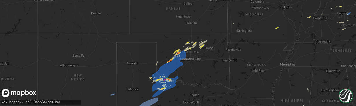
Hail
Wind
72,264
Estimated number of impacted properties by a 1.00" hail or larger15,966
Estimated number of impacted properties by a 1.75" hail or larger192
Estimated number of impacted properties by a 2.50" hail or largerStates Impacted by Hail Map on April 1, 2026
Storm reports
Ohio
| Date | Description |
|---|---|
| 04/01/20265:17 PM CDT | Large tree down blocking ohio avenue. Time estimated from radar. |
| 04/01/20264:44 PM CDT | Sign blown off business. Time estimated from radar. |
| 04/01/20264:30 PM CDT | Tree snap off and destroyed on the property of a home with a fence knocked over. Time estimated by radar. Picture provided via social media. |
| 04/01/20264:25 PM CDT | Numerous trees down reported by someone on social media. Pictures provided. Time estimated by radar. |
| 04/01/20264:22 PM CDT | Report from mping: half dollar |
| 04/01/20264:20 PM CDT | Power lines down along pike street in marietta. |
| 04/01/20264:20 PM CDT | Photo showing quarter size hail. |
| 04/01/20264:19 PM CDT | Corrects previous hail report from 1 ese marietta. Large hail estimated at half inch to quarter size. Time estimated from radar. |
| 04/01/20264:19 PM CDT | Large hail estimated at half inch to quarter size. Time estimated from radar. |
| 04/01/20264:17 PM CDT | A local report indicates 1.00 inch wind near Williamstown |
| 04/01/20264:17 PM CDT | Photos include pictures of between half dollar to ping pong ball size hail. |
| 04/01/20264:17 PM CDT | Report from mping: half dollar |
| 04/01/20264:16 PM CDT | Hail up to 1.1 in and accumulation of smaller hail. |
| 04/01/20264:16 PM CDT | A local report indicates 1.00 inch wind near 1 SE Marietta |
| 04/01/20264:16 PM CDT | From photo provided to the media. Time is estimated from radar. |
| 04/01/20264:15 PM CDT | A local report indicates 1.00 inch wind near 6 WSW Marietta |
| 04/01/20264:15 PM CDT | Tree and numerous branches down on a house off 2nd street in marietta. Extensive damage to the home. Time estimated by radar. Picture provided. |
| 04/01/20264:15 PM CDT | Corrects previous hail report from 1 w marietta. Ping pong to golf ball sized hail reported across marietta. Time estimated by radar. |
| 04/01/20264:14 PM CDT | Caller witnessed part of a roof blown off of a nearby house. Time estimated from radar. |
| 04/01/20263:41 PM CDT | Tree into powerlines and powerlines on fire at state rt 550 and murphy rd. |
| 04/01/20261:28 PM CDT | Observed along bracken ridge rd. |
| 04/01/20261:23 PM CDT | A local report indicates 1.00 inch wind near 2 SSE Summerfield |
| 04/01/20261:20 PM CDT | Size estimated from social media. |
Idaho
| Date | Description |
|---|---|
| 04/01/20264:47 AM CDT | Mesonet station crii1 cotton ridge. |
| 04/01/20264:22 AM CDT | Asos station kida idaho falls regional airport. |
| 04/01/20263:41 AM CDT | Asos station kpih pocatello regional airport. |
Kentucky
| Date | Description |
|---|---|
| 04/01/20264:41 PM CDT | Broadcast media relayed pictures of a metal garage roof torn off. Time estimated from radar. |
| 04/01/20264:25 PM CDT | Tree down across road blocking the entire road on town hill road. Time estimated by radar. |
| 04/01/20263:59 PM CDT | Tree down blocking roadway on sims cemetery rd. Time estimated from radar. |
| 04/01/20263:49 PM CDT | Social media video of lots of hail falling along ky-589... About 1.5 miles from its intersection with ky-172. The individual reports that the largest hail stones were q |
| 04/01/20263:29 PM CDT | Social media user posted a video of hail and reported golf ball sized hailstones near the intersection of ky519 and ky7. Time estimated by radar. |
| 04/01/20263:27 PM CDT | Small branches down with heavy rain... At least 60 mph winds. |
| 04/01/20263:27 PM CDT | Social media user shared photo of hail stone and estimates ping pong size. Hail was retrieved off of liberty rd near arh hospital. Time estimated from radar. |
| 04/01/20263:20 PM CDT | Social media video shows pile of approximately quarter sized hail near west liberty. Time estimated by radar. |
| 04/01/202612:51 PM CDT | Tree damage resulting in 54 customers without power. |
West Virginia
| Date | Description |
|---|---|
| 04/01/20266:35 PM CDT | A local report indicates 61 MPH wind near 3 WSW Clarksburg |
| 04/01/20266:35 PM CDT | Tree down along 2nd street in clarksburg... Time estimated from radar. |
| 04/01/20265:52 PM CDT | Tree reported down in roadway. |
| 04/01/20265:42 PM CDT | Tree down blocking gnats run road. Time estimated from radar. |
| 04/01/20265:40 PM CDT | Tree in roadway on wv-14 & rose hill rd. Time estimated from radar. |
| 04/01/20265:33 PM CDT | Tree and power lines down. Time estimated from radar. |
| 04/01/20265:31 PM CDT | Tree down in lines. Time estimated from radar. |
| 04/01/20265:22 PM CDT | Tree down blocking glendale road in cairo. Time estimated from radar. |
| 04/01/20265:08 PM CDT | Trees down in hazleton. Time estimated from radar. |
| 04/01/20265:07 PM CDT | Tree along robert byrd highway and progress ridge road blocking traffic. |
| 04/01/20265:04 PM CDT | Corrects previous non-tstm wnd dmg report from 5 ne mineral wells. Tree across little stillwell road. |
| 04/01/20265:01 PM CDT | Tree down on a house. |
| 04/01/20264:59 PM CDT | Tree down on car and shed. |
| 04/01/20264:57 PM CDT | Power lines down. Time estimated from radar. |
| 04/01/20264:53 PM CDT | Power lines down along 22nd street. |
| 04/01/20264:52 PM CDT | Tree down. |
| 04/01/20264:49 PM CDT | A couple of simultaneous reports of quarter-sized hail in parkersburg... One on 19th street. |
| 04/01/20264:40 PM CDT | A local report indicates 1.00 inch wind near 1 NE Belmont |
| 04/01/20264:40 PM CDT | Size estimated from a photo on social media. Time is estimated by radar. |
| 04/01/20264:30 PM CDT | One inch size hail reported at pipestem resort state park. |
| 04/01/20264:18 PM CDT | Ping-pong sized hail. Cocorahs station wd-7. |
| 04/01/20264:17 PM CDT | Time is estimated by radar. |
| 04/01/20264:15 PM CDT | Report from mping: ping pong ball |
| 04/01/20263:50 PM CDT | Tree down on clyburn st. In sprague. |
| 04/01/20263:46 PM CDT | Tree and power lines down. Time estimated from radar. |
| 04/01/20263:44 PM CDT | Tree down on crossroads road. Time estimated from radar. |
| 04/01/20263:43 PM CDT | Tree down. Time estimated from radar. |
| 04/01/20263:38 PM CDT | Corrects previous tstm wnd dmg report from beckley. Tree reported down. Time is estimated by radar. |
| 04/01/20263:28 PM CDT | Tree down on road. Time estimated from radar. |
| 04/01/20263:12 PM CDT | A local report indicates 1.00 inch wind near 1 N Daniels |
| 04/01/20263:03 PM CDT | A local report indicates 1.00 inch wind near 1 E Beaver |
| 04/01/20262:31 PM CDT | Tree down along bulldog boulevard. Time estimated from radar. |
| 04/01/20262:05 PM CDT | 500 customers without power due to tree damage in the pecks mill area. |
| 04/01/20261:20 PM CDT | Trained spotter near crum... Wv measured half dollar size hail. |
Oregon
| Date | Description |
|---|---|
| 03/31/20267:13 PM CDT | Mesonet station od185 i84 wb at cabbage hill mp223.52. |
| 03/31/20267:06 PM CDT | Asos station kpdt pendleton... Or |
Maryland
| Date | Description |
|---|---|
| 04/01/20265:56 PM CDT | A local report indicates 1.00 inch wind near 1 W Halfway |
| 04/01/20265:23 PM CDT | Tree reported down in sang run area. |
| 03/31/202610:02 PM CDT | Tree down on st johns road near intersection with three notch road. |
Oklahoma
| Date | Description |
|---|---|
| 04/01/20266:45 PM CDT | A local report indicates 59 MPH wind near 2 NNW Hester |
| 04/01/20266:15 PM CDT | A local report indicates 61 MPH wind near 3 W Gould |
| 04/01/20266:03 PM CDT | Report from x with pictures. |
| 04/01/20265:57 PM CDT | Report from mping: quarter |
| 04/01/20265:50 PM CDT | A local report indicates 3.50 inch wind near 5 E Watonga |
| 04/01/20265:47 PM CDT | Report from mping: tennis ball |
| 03/31/20269:03 PM CDT | Report relayed by amateur radio operator... Also estimated 60mph wind. |
| 03/31/20267:40 PM CDT | Delayed report. Report from mping: quarter |
| 03/31/20267:35 PM CDT | A local report indicates 67 MPH wind near 4 WSW Weatherford |
| 03/31/20267:00 PM CDT | A local report indicates 60 MPH wind near 3 WNW Headrick |
Delaware
| Date | Description |
|---|---|
| 04/01/20266:34 PM CDT | Several reports of large trees and power lines down in smyrna. Time estimated from radar. |
| 04/01/20266:30 PM CDT | Tree down onto a house in the clayton courts neighborhood. Time estimated from radar. |
| 04/01/20266:30 PM CDT | Several reports of large trees and power lines down in clayton. Time estimated from radar. |
| 03/31/202610:19 PM CDT | Multiple reports of trees down in milford. Time estimated from radar. |
Washington
| Date | Description |
|---|---|
| 03/31/20268:20 PM CDT | Report of a tree blown down. Time estimated from radar. |
Indiana
| Date | Description |
|---|---|
| 04/01/20266:01 PM CDT | Photo on facebook showing a large pine tree uprooted. Time estimated via radar. Delayed report. |
| 04/01/20263:16 PM CDT | Tree was reported down blocking roadway at n. K rd and old sr 62. Time estimated by radar. |
Missouri
| Date | Description |
|---|---|
| 04/01/20265:50 PM CDT | High winds broke at least 3 3-phase poles... Causing power outages for over 649 members west of lebanon toward long lane. |
New Mexico
| Date | Description |
|---|---|
| 04/01/20265:51 PM CDT | A local report indicates 63 MPH wind near 2 SW Tatum |
Texas
| Date | Description |
|---|---|
| 04/01/20266:57 PM CDT | A local report indicates 61 MPH wind near 3 E Snyder |
| 04/01/20266:50 PM CDT | A local report indicates 66 MPH wind near 3 SSW Snyder |
| 04/01/20266:38 PM CDT | Initial gust of 69 mph at 6:36 pm cdt. West texas mesonet. |
| 04/01/20266:31 PM CDT | Power poles/lines down. |
| 04/01/20265:45 PM CDT | West texas mesonet. |
| 04/01/20265:40 PM CDT | Also gusted to 61 mph at 536 pm cdt. Measured by childress asos. |
| 03/31/20269:22 PM CDT | A local report indicates 62 MPH wind near 1 S Mankins |
| 03/31/20268:50 PM CDT | A local report indicates 69 MPH wind near 3 NW Seymour |
| 03/31/20268:30 PM CDT | A local report indicates 60 MPH wind near 4 NNW Goree |
| 03/31/20268:30 PM CDT | A local report indicates 60 MPH wind near 6 NE Munday |
| 03/31/20268:30 PM CDT | A local report indicates 60 MPH wind near 3 NW Knox City |
| 03/31/20268:22 PM CDT | A local report indicates 62 MPH wind near Weinert |
| 03/31/20268:20 PM CDT | A local report indicates 72 MPH wind near 3 NW Knox City |
| 03/31/20268:15 PM CDT | A local report indicates 72 MPH wind near 3 NW Knox City |
| 03/31/20268:09 PM CDT | Roof damage. |
| 03/31/20268:02 PM CDT | A local report indicates 75 MPH wind near 5 SW Saint Lawrence |
| 03/31/20267:50 PM CDT | Couple power lines blown down in town. |
| 03/31/20267:27 PM CDT | Delayed report. Report from mping: quarter |
| 03/31/20267:27 PM CDT | A local report indicates 65 MPH wind near Rotan |
North Carolina
| Date | Description |
|---|---|
| 04/01/20261:14 PM CDT | A local report indicates 1.00 inch wind near 1 E Deep Gap |
Virginia
| Date | Description |
|---|---|
| 04/01/20266:11 PM CDT | Corrects previous tstm wnd dmg report from 4 e appomattox. Tree down along river ridge road. |
| 04/01/20266:11 PM CDT | Tree down along old courthouse road. |
| 04/01/20266:03 PM CDT | Tree down along redfields road. |
| 04/01/20266:03 PM CDT | Tree down on power lines along church street. |
| 04/01/20266:02 PM CDT | Tree down along cornfield lane. |
| 04/01/20265:45 PM CDT | Multiple reports of trees down in covesville. |
| 04/01/20264:09 PM CDT | A local report indicates 1.00 inch wind near 3 WNW Stewartsville |
| 04/01/20264:08 PM CDT | A local report indicates 1.00 inch wind near Clifton |
| 04/01/20263:47 PM CDT | A local report indicates 1.00 inch wind near 2 NW Manassas Park |
| 04/01/20263:35 PM CDT | A local report indicates 1.00 inch wind near Clifton |
| 04/01/20261:54 PM CDT | Report relayed from wset/abc13. |
| 04/01/20261:50 PM CDT | A local report indicates 1.00 inch wind near 4 NE Forest |
| 04/01/20261:43 PM CDT | A local report indicates 1.50 inch wind near 3 NW Forest |
| 04/01/20261:41 PM CDT | Hail of at least 1 inch in diameter was observed along mcintosh drive. |
| 04/01/20261:12 PM CDT | Hail of around 1 in diameter was observed along wheats valley road. |
| 04/01/20261:08 PM CDT | A local report indicates 1.00 inch wind near 7 NNE Thaxton |
| 03/31/20269:00 PM CDT | A tree was blown down by thunderstorm winds near the intersection of lola avenue and frazier road... Partially blocking the road. |
| 03/31/20268:00 PM CDT | Tree down blocking hidden valley drive. |
| 03/31/20267:56 PM CDT | Tree down across both lanes of daniels creek road. |
Cities Impacted by Hail Map on April 1, 2026
- London, KY
- Norris City, IL
- Enfield, IL
- Broughton, IL
- McLeansboro, IL
- Welch, WV
- Jackson, KY
- Gays Creek, KY
- Buckhorn, KY
- Anawalt, WV
- Carmi, IL
- Maybeury, WV
- Ulysses, KY
- Louisa, KY
- Bedford, VA
- Fort Gay, WV
- Warfield, KY
- Kermit, WV
- Inez, KY
- Crum, WV
- Boone, NC
- Deep Gap, NC
- Hyden, KY
- Caldwell, OH
- Sarahsville, OH
- Summerfield, OH
- Lewisville, OH
- Wooton, KY
- Hazard, KY
- Fleetwood, NC
- Wilsondale, WV
- Breeden, WV
- Tomahawk, KY
- French Lick, IN
- Krypton, KY
- Dubois, IN
- Debord, KY
- Viper, KY
- Forest, VA
- Goode, VA
- Lynchburg, VA
- Elberfeld, IN
- Harts, WV
- Dingess, WV
- Purlear, NC
- Ellington, MO
- Woodsfield, OH
- Chapmanville, WV
- Jerusalem, OH
- Redford, MO
- Big Creek, WV
- Pilgrim, KY
- Lynnville, IN
- Orleans, IN
- Campbellsburg, IN
- Lesterville, MO
- Rockbridge, OH
- Laurelville, OH
- Stockport, OH
- Malta, OH
- Lovely, KY
- Lenore, WV
- Williamson, WV
- Salem, IN
- Beallsville, OH
- Cameron, OH
- Clarington, OH
- Proctor, WV
- Glen Easton, WV
- Omar, WV
- Delbarton, WV
- Millers Creek, NC
- Holden, WV
- Scottsburg, IN
- Annapolis, MO
- Pecks Mill, WV
- New Martinsville, WV
- Cameron, WV
- Collinsville, MS
- Sarah Ann, WV
- Bim, WV
- Clothier, WV
- Columbus, MS
- Bogalusa, LA
- Lowry, VA
- Ezel, KY
- West Liberty, KY
- Littleton, WV
- Friendsville, MD
- Bruceton Mills, WV
- Louisville, KY
- West Point, MS
- Fisherville, KY
- Wana, WV
- Mannington, WV
- Metz, WV
- Cutler, OH
- Chesterhill, OH
- Amesville, OH
- Rock Creek, WV
- Hundred, WV
- Burton, WV
- Waterford, OH
- Elkfork, KY
- Monticello, GA
- Franklinton, LA
- Simpsonville, KY
- Shelbyville, KY
- Finchville, KY
- Hardyville, KY
- Canmer, KY
- Munfordville, KY
- Manassas, VA
- Vincent, OH
- Fleming, OH
- Frostburg, MD
- Fairview, WV
- Whipple, OH
- Marietta, OH
- Lowell, OH
- Williamstown, WV
- Rivesville, WV
- Summersville, KY
- Magnolia, KY
- Reynolds, GA
- Butler, GA
- Salisbury, PA
- Guysville, OH
- Stewart, OH
- Newport, OH
- Reno, OH
- Coolville, OH
- Alma, WV
- Jacksonburg, WV
- West Union, WV
- Flat Top, WV
- Flag Pond, TN
- Hyndman, PA
- Bristow, VA
- Gainesville, VA
- Pine Grove, WV
- Reader, WV
- Greensburg, KY
- Belmont, WV
- Saint Marys, WV
- Little Hocking, OH
- Belpre, OH
- Center Point, WV
- Maidsville, WV
- Bardstown, KY
- Rachel, WV
- Farmington, WV
- Fairmont, WV
- Ballard, WV
- Troutville, VA
- Thomas, OK
- Middleport, OH
- Washington, WV
- Monroe, VA
- Forest Hill, WV
- Pipestem, WV
- Coxs Creek, KY
- Rutland, OH
- Pomeroy, OH
- Cheshire, OH
- Beverly, OH
- Masontown, WV
- Lerona, WV
- Parkersburg, WV
- Vienna, WV
- Waverly, WV
- Morgantown, WV
- Albright, WV
- Racine, OH
- New Haven, WV
- Hartford, WV
- Mason, WV
- Syracuse, OH
- Letart, WV
- West Columbia, WV
- Roanoke, VA
- Baxter, WV
- Fay, OK
- Watonga, OK
- Paris, KY
- Oakwood, OK
- Campton, KY
- Salyersville, KY
- Sandy Hook, KY
- Canton, OK
- Hinton, WV
- Friendly, WV
- Walker, WV
- New Castle, VA
- Sharpsburg, KY
- Carlisle, KY
- Bidwell, OH
- Gallipolis, OH
- Big Island, VA
- Matador, TX
- Hitchcock, OK
- Okeene, OK
- Cairo, WV
- Ellenboro, WV
- Cee Vee, TX
- Childress, TX
- Greenfield, OK
- Enid, OK
- Geary, OK
- Petroleum, WV
- Owingsville, KY
- Hedgesville, WV
- Wellington, KY
- Paducah, TX
- Fairmont, OK
- Garber, OK
- Hillsboro, KY
- Frenchburg, KY
- Tell, TX
- Kingwood, WV
- Kingfisher, OK
- Quanah, TX
- Crowell, TX
- Pennsboro, WV
- Rineyville, KY
- Cecilia, KY
- Lamar, MO
- Custer, KY
- Mulhall, OK
- Orlando, OK
- Whitesville, WV
- Glen Daniel, WV
- Beckley, WV
- Hennessey, OK
- Sheldon, MO
- Dover, OK
- Eastview, KY
- Hunter, OK
- Spout Spring, VA
- Appomattox, VA
- Hollis, OK
- Gould, OK
- Eldorado, OK
- Chillicothe, TX
- Duke, OK
- Vinson, OK
- Mangum, OK
- Dill City, OK
- Sentinel, OK
- Omega, OK
- Marshall, OK
- Athens, OH
- Elizabethtown, KY
- Long Bottom, OH
- Wellington, TX
- Erick, OK
- Shade, OH
- Red Rock, OK
- Billings, OK
- Cordell, OK
- Vernon, TX
- Odell, TX
- Olustee, OK
- Altus, OK
- Elmer, OK
- Blair, OK
- Crescent, OK
- Covington, OK
- Perry, OK
- Texola, OK
- Foss, OK
- Middlebourne, WV
- Salem, WV
- Seymour, TX
- Old Glory, TX
- Bridgeport, WV
- Clarksburg, WV
- Mount Clare, WV
- Anmoore, WV
- Meadowbrook, WV
- Corn, OK
- Morrison, OK
- Pawnee, OK
- Bessie, OK
- Willow, OK
- Granite, OK
- Carter, OK
- Lone Wolf, OK
- Altus Afb, OK
- Headrick, OK
- Mountain Park, OK
- Roosevelt, OK
- Tipton, OK
- Ralston, OK
- Clinton, OK
- Weatherford, OK
- Falling Waters, WV
- Williamsport, MD
- Frederick, OK
- Benjamin, TX
- Rocky, OK
- Hobart, OK
- Snyder, OK
- Davidson, OK
- Oklaunion, TX
- Harrold, TX
- Stillwater, OK
- Coleman Falls, VA
- Fairfax, OK
- Hydro, OK
- Gotebo, OK
- Electra, TX
- Hollister, OK
- Loraine, TX
- Roscoe, TX
- Sweetwater, TX
- Colorado City, TX
- Munday, TX
- Rustburg, VA
- Salem, VA
- Roby, TX
- Hermleigh, TX
- McCaulley, TX
- Sylvester, TX
- Snyder, TX
- Rotan, TX
- Jayton, TX
- Aspermont, TX
- Rochester, TX
- O'Brien, TX
- Rule, TX
- Goree, TX
- Hominy, OK
- Daleville, VA
- Walters, OK
- Lawton, OK
- Mountain View, OK
- Faxon, OK
- Indiahoma, OK
- Chattanooga, OK
- Devol, OK
- Randlett, OK
- Cache, OK
- Loveland, OK
- Grandfield, OK
- Knox City, TX
- Haskell, TX
- Weinert, TX
- Anson, TX
- Hamlin, TX
- Carnegie, OK
- Elgin, OK
- Apache, OK
- Medicine Park, OK
- Fort Cobb, OK
- Anadarko, OK
- Pocasset, OK
- Gracemont, OK
- Lookeba, OK
- Hinton, OK
- Minco, OK
- Binger, OK
- Colony, OK
- Calumet, OK
- Okarche, OK
- El Reno, OK
- Union City, OK
- Wynona, OK
- Saint Albans, WV
- Hurricane, WV
- Maramec, OK
- Cleveland, OK
- Jennings, OK
- Burkburnett, TX
- Iowa Park, TX
- Stamford, TX
- Wichita Falls, TX
- Sheppard Afb, TX
- Yale, OK
- Waukomis, OK
- Terlton, OK
- Barnsdall, OK
- Chickasha, OK
- Verden, OK
- Yukon, OK
- Holliday, TX
- Temple, OK
- Osage, OK
- Piedmont, OK
- Pawhuska, OK
- Martha, KY
- Avenue, MD
- Abell, MD
- Bushwood, MD
- Leonardtown, MD
- Robert Lee, TX
- Mechanicsville, MD
- Hollywood, MD
- California, MD
- Bronte, TX
- Carlsbad, TX
- Georgetown, DE
- Mertzon, TX
- Millsboro, DE
- San Angelo, TX
- Menard, TX
- Eldorado, TX
- Daniels, WV
- Beaver, WV
- Pickrell, NE
- Cortland, NE
- Sonora, TX
- Ira, TX
- Coahoma, TX
- Westbrook, TX
- Big Spring, TX
- Sterling City, TX
- Garden City, TX
- Midkiff, TX
- Big Lake, TX
- Tatum, NM
- Portland, OH
- Jumping Branch, WV