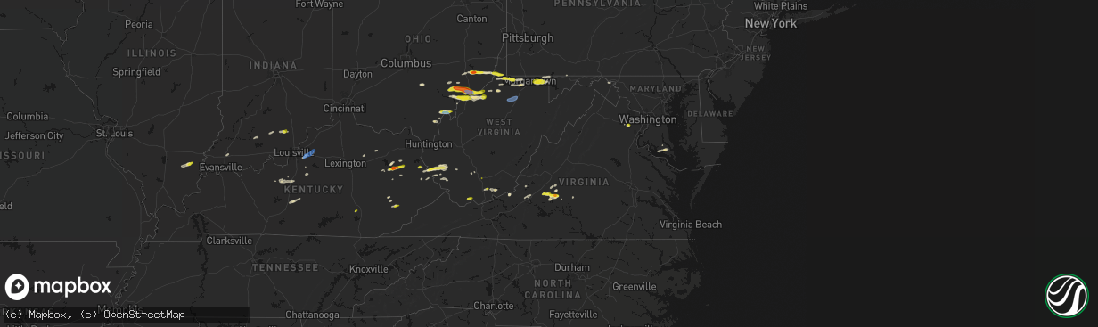
Hail Map in Virginia on April 1, 2026
The weather event in Virginia on April 1, 2026 includes Hail and Wind maps. 19 states and 423 cities were impacted and suffered possible damage. The total estimated number of properties impacted is 9,156.
Hail
Wind
9,156
Estimated number of impacted properties by a 1.00" hail or larger0
Estimated number of impacted properties by a 1.75" hail or larger0
Estimated number of impacted properties by a 2.50" hail or largerStorm reports in Virginia
Virginia
| Date | Description |
|---|---|
| 04/01/20266:11 PM CDT | Tree down along old courthouse road. |
| 04/01/20266:11 PM CDT | Corrects previous tstm wnd dmg report from 4 e appomattox. Tree down along river ridge road. |
| 04/01/20266:03 PM CDT | Tree down along redfields road. |
| 04/01/20266:03 PM CDT | Tree down on power lines along church street. |
| 04/01/20266:02 PM CDT | Tree down along cornfield lane. |
| 04/01/20265:45 PM CDT | Multiple reports of trees down in covesville. |
| 04/01/20264:09 PM CDT | A local report indicates 1.00 inch wind near 3 WNW Stewartsville |
| 04/01/20264:08 PM CDT | A local report indicates 1.00 inch wind near Clifton |
| 04/01/20263:47 PM CDT | A local report indicates 1.00 inch wind near 2 NW Manassas Park |
| 04/01/20263:35 PM CDT | A local report indicates 1.00 inch wind near Clifton |
| 04/01/20261:54 PM CDT | Report relayed from wset/abc13. |
| 04/01/20261:50 PM CDT | A local report indicates 1.00 inch wind near 4 NE Forest |
| 04/01/20261:43 PM CDT | A local report indicates 1.50 inch wind near 3 NW Forest |
| 04/01/20261:41 PM CDT | Hail of at least 1 inch in diameter was observed along mcintosh drive. |
| 04/01/20261:12 PM CDT | Hail of around 1 in diameter was observed along wheats valley road. |
| 04/01/20261:08 PM CDT | A local report indicates 1.00 inch wind near 7 NNE Thaxton |
| 03/31/20269:00 PM CDT | A tree was blown down by thunderstorm winds near the intersection of lola avenue and frazier road... Partially blocking the road. |
| 03/31/20268:00 PM CDT | Tree down blocking hidden valley drive. |
| 03/31/20267:56 PM CDT | Tree down across both lanes of daniels creek road. |
All States Impacted by Hail Map on April 1, 2026
Cities Impacted by Hail Map on April 1, 2026
- London, KY
- Norris City, IL
- Enfield, IL
- Broughton, IL
- McLeansboro, IL
- Welch, WV
- Jackson, KY
- Gays Creek, KY
- Buckhorn, KY
- Anawalt, WV
- Carmi, IL
- Maybeury, WV
- Ulysses, KY
- Louisa, KY
- Bedford, VA
- Fort Gay, WV
- Warfield, KY
- Kermit, WV
- Inez, KY
- Crum, WV
- Boone, NC
- Deep Gap, NC
- Hyden, KY
- Caldwell, OH
- Sarahsville, OH
- Summerfield, OH
- Lewisville, OH
- Wooton, KY
- Hazard, KY
- Fleetwood, NC
- Wilsondale, WV
- Breeden, WV
- Tomahawk, KY
- French Lick, IN
- Krypton, KY
- Dubois, IN
- Debord, KY
- Viper, KY
- Forest, VA
- Goode, VA
- Lynchburg, VA
- Elberfeld, IN
- Harts, WV
- Dingess, WV
- Purlear, NC
- Ellington, MO
- Woodsfield, OH
- Chapmanville, WV
- Jerusalem, OH
- Redford, MO
- Big Creek, WV
- Pilgrim, KY
- Lynnville, IN
- Orleans, IN
- Campbellsburg, IN
- Lesterville, MO
- Rockbridge, OH
- Laurelville, OH
- Stockport, OH
- Malta, OH
- Lovely, KY
- Lenore, WV
- Williamson, WV
- Salem, IN
- Beallsville, OH
- Cameron, OH
- Clarington, OH
- Proctor, WV
- Glen Easton, WV
- Omar, WV
- Delbarton, WV
- Millers Creek, NC
- Holden, WV
- Scottsburg, IN
- Annapolis, MO
- Pecks Mill, WV
- New Martinsville, WV
- Cameron, WV
- Collinsville, MS
- Sarah Ann, WV
- Bim, WV
- Clothier, WV
- Columbus, MS
- Bogalusa, LA
- Lowry, VA
- Ezel, KY
- West Liberty, KY
- Littleton, WV
- Friendsville, MD
- Bruceton Mills, WV
- Louisville, KY
- West Point, MS
- Fisherville, KY
- Wana, WV
- Mannington, WV
- Metz, WV
- Cutler, OH
- Chesterhill, OH
- Amesville, OH
- Rock Creek, WV
- Hundred, WV
- Burton, WV
- Waterford, OH
- Elkfork, KY
- Monticello, GA
- Franklinton, LA
- Simpsonville, KY
- Shelbyville, KY
- Finchville, KY
- Hardyville, KY
- Canmer, KY
- Munfordville, KY
- Manassas, VA
- Vincent, OH
- Fleming, OH
- Frostburg, MD
- Fairview, WV
- Whipple, OH
- Marietta, OH
- Lowell, OH
- Williamstown, WV
- Rivesville, WV
- Summersville, KY
- Magnolia, KY
- Reynolds, GA
- Butler, GA
- Salisbury, PA
- Guysville, OH
- Stewart, OH
- Newport, OH
- Reno, OH
- Coolville, OH
- Alma, WV
- Jacksonburg, WV
- West Union, WV
- Flat Top, WV
- Flag Pond, TN
- Hyndman, PA
- Bristow, VA
- Gainesville, VA
- Pine Grove, WV
- Reader, WV
- Greensburg, KY
- Belmont, WV
- Saint Marys, WV
- Little Hocking, OH
- Belpre, OH
- Center Point, WV
- Maidsville, WV
- Bardstown, KY
- Rachel, WV
- Farmington, WV
- Fairmont, WV
- Ballard, WV
- Troutville, VA
- Thomas, OK
- Middleport, OH
- Washington, WV
- Monroe, VA
- Forest Hill, WV
- Pipestem, WV
- Coxs Creek, KY
- Rutland, OH
- Pomeroy, OH
- Cheshire, OH
- Beverly, OH
- Masontown, WV
- Lerona, WV
- Parkersburg, WV
- Vienna, WV
- Waverly, WV
- Morgantown, WV
- Albright, WV
- Racine, OH
- New Haven, WV
- Hartford, WV
- Mason, WV
- Syracuse, OH
- Letart, WV
- West Columbia, WV
- Roanoke, VA
- Baxter, WV
- Fay, OK
- Watonga, OK
- Paris, KY
- Oakwood, OK
- Campton, KY
- Salyersville, KY
- Sandy Hook, KY
- Canton, OK
- Hinton, WV
- Friendly, WV
- Walker, WV
- New Castle, VA
- Sharpsburg, KY
- Carlisle, KY
- Bidwell, OH
- Gallipolis, OH
- Big Island, VA
- Matador, TX
- Hitchcock, OK
- Okeene, OK
- Cairo, WV
- Ellenboro, WV
- Cee Vee, TX
- Childress, TX
- Greenfield, OK
- Enid, OK
- Geary, OK
- Petroleum, WV
- Owingsville, KY
- Hedgesville, WV
- Wellington, KY
- Paducah, TX
- Fairmont, OK
- Garber, OK
- Hillsboro, KY
- Frenchburg, KY
- Tell, TX
- Kingwood, WV
- Kingfisher, OK
- Quanah, TX
- Crowell, TX
- Pennsboro, WV
- Rineyville, KY
- Cecilia, KY
- Lamar, MO
- Custer, KY
- Mulhall, OK
- Orlando, OK
- Whitesville, WV
- Glen Daniel, WV
- Beckley, WV
- Hennessey, OK
- Sheldon, MO
- Dover, OK
- Eastview, KY
- Hunter, OK
- Spout Spring, VA
- Appomattox, VA
- Hollis, OK
- Gould, OK
- Eldorado, OK
- Chillicothe, TX
- Duke, OK
- Vinson, OK
- Mangum, OK
- Dill City, OK
- Sentinel, OK
- Omega, OK
- Marshall, OK
- Athens, OH
- Elizabethtown, KY
- Long Bottom, OH
- Wellington, TX
- Erick, OK
- Shade, OH
- Red Rock, OK
- Billings, OK
- Cordell, OK
- Vernon, TX
- Odell, TX
- Olustee, OK
- Altus, OK
- Elmer, OK
- Blair, OK
- Crescent, OK
- Covington, OK
- Perry, OK
- Texola, OK
- Foss, OK
- Middlebourne, WV
- Salem, WV
- Seymour, TX
- Old Glory, TX
- Bridgeport, WV
- Clarksburg, WV
- Mount Clare, WV
- Anmoore, WV
- Meadowbrook, WV
- Corn, OK
- Morrison, OK
- Pawnee, OK
- Bessie, OK
- Willow, OK
- Granite, OK
- Carter, OK
- Lone Wolf, OK
- Altus Afb, OK
- Headrick, OK
- Mountain Park, OK
- Roosevelt, OK
- Tipton, OK
- Ralston, OK
- Clinton, OK
- Weatherford, OK
- Falling Waters, WV
- Williamsport, MD
- Frederick, OK
- Benjamin, TX
- Rocky, OK
- Hobart, OK
- Snyder, OK
- Davidson, OK
- Oklaunion, TX
- Harrold, TX
- Stillwater, OK
- Coleman Falls, VA
- Fairfax, OK
- Hydro, OK
- Gotebo, OK
- Electra, TX
- Hollister, OK
- Loraine, TX
- Roscoe, TX
- Sweetwater, TX
- Colorado City, TX
- Munday, TX
- Rustburg, VA
- Salem, VA
- Roby, TX
- Hermleigh, TX
- McCaulley, TX
- Sylvester, TX
- Snyder, TX
- Rotan, TX
- Jayton, TX
- Aspermont, TX
- Rochester, TX
- O'Brien, TX
- Rule, TX
- Goree, TX
- Hominy, OK
- Daleville, VA
- Walters, OK
- Lawton, OK
- Mountain View, OK
- Faxon, OK
- Indiahoma, OK
- Chattanooga, OK
- Devol, OK
- Randlett, OK
- Cache, OK
- Loveland, OK
- Grandfield, OK
- Knox City, TX
- Haskell, TX
- Weinert, TX
- Anson, TX
- Hamlin, TX
- Carnegie, OK
- Elgin, OK
- Apache, OK
- Medicine Park, OK
- Fort Cobb, OK
- Anadarko, OK
- Pocasset, OK
- Gracemont, OK
- Lookeba, OK
- Hinton, OK
- Minco, OK
- Binger, OK
- Colony, OK
- Calumet, OK
- Okarche, OK
- El Reno, OK
- Union City, OK
- Wynona, OK
- Saint Albans, WV
- Hurricane, WV
- Maramec, OK
- Cleveland, OK
- Jennings, OK
- Burkburnett, TX
- Iowa Park, TX
- Stamford, TX
- Wichita Falls, TX
- Sheppard Afb, TX
- Yale, OK
- Waukomis, OK
- Terlton, OK
- Barnsdall, OK
- Chickasha, OK
- Verden, OK
- Yukon, OK
- Holliday, TX
- Temple, OK
- Osage, OK
- Piedmont, OK
- Pawhuska, OK
- Martha, KY
- Avenue, MD
- Abell, MD
- Bushwood, MD
- Leonardtown, MD
- Robert Lee, TX
- Mechanicsville, MD
- Hollywood, MD
- California, MD
- Bronte, TX
- Carlsbad, TX
- Georgetown, DE
- Mertzon, TX
- Millsboro, DE
- San Angelo, TX
- Menard, TX
- Eldorado, TX
- Daniels, WV
- Beaver, WV
- Pickrell, NE
- Cortland, NE
- Sonora, TX
- Ira, TX
- Coahoma, TX
- Westbrook, TX
- Big Spring, TX
- Sterling City, TX
- Garden City, TX
- Midkiff, TX
- Big Lake, TX
- Tatum, NM
- Portland, OH
- Jumping Branch, WV


