Hail Map in West Liberty, KY on April 1, 2026
The weather event in West Liberty, KY on April 1, 2026 includes Hail and Wind maps. 19 states and 423 cities were impacted and suffered possible damage. The total estimated number of properties impacted is 1,338.
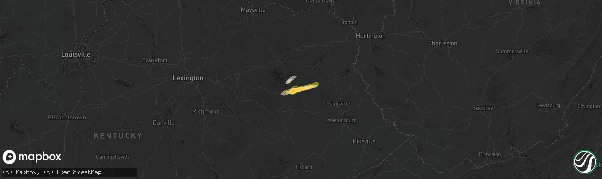
Hail
Wind
1,338
Estimated number of impacted properties by a 1.00" hail or larger546
Estimated number of impacted properties by a 1.75" hail or larger0
Estimated number of impacted properties by a 2.50" hail or largerStorm reports in West Liberty, KY
West Liberty, KY
| Date | Description |
|---|---|
| 04/01/20263:49 PM CDT | Social media video of lots of hail falling along ky-589... About 1.5 miles from its intersection with ky-172. The individual reports that the largest hail stones were q |
| 04/01/20263:29 PM CDT | Social media user posted a video of hail and reported golf ball sized hailstones near the intersection of ky519 and ky7. Time estimated by radar. |
| 04/01/20263:27 PM CDT | Social media user shared photo of hail stone and estimates ping pong size. Hail was retrieved off of liberty rd near arh hospital. Time estimated from radar. |
| 04/01/20263:20 PM CDT | Social media video shows pile of approximately quarter sized hail near west liberty. Time estimated by radar. |
All States Impacted by Hail Map on April 1, 2026
All Cities Impacted by Hail Map on April 1, 2026
- London, KY
- Norris City, IL
- Enfield, IL
- Broughton, IL
- McLeansboro, IL
- Welch, WV
- Jackson, KY
- Gays Creek, KY
- Buckhorn, KY
- Anawalt, WV
- Carmi, IL
- Maybeury, WV
- Ulysses, KY
- Louisa, KY
- Bedford, VA
- Fort Gay, WV
- Warfield, KY
- Kermit, WV
- Inez, KY
- Crum, WV
- Boone, NC
- Deep Gap, NC
- Hyden, KY
- Caldwell, OH
- Sarahsville, OH
- Summerfield, OH
- Lewisville, OH
- Wooton, KY
- Hazard, KY
- Fleetwood, NC
- Wilsondale, WV
- Breeden, WV
- Tomahawk, KY
- French Lick, IN
- Krypton, KY
- Dubois, IN
- Debord, KY
- Viper, KY
- Forest, VA
- Goode, VA
- Lynchburg, VA
- Elberfeld, IN
- Harts, WV
- Dingess, WV
- Purlear, NC
- Ellington, MO
- Woodsfield, OH
- Chapmanville, WV
- Jerusalem, OH
- Redford, MO
- Big Creek, WV
- Pilgrim, KY
- Lynnville, IN
- Orleans, IN
- Campbellsburg, IN
- Lesterville, MO
- Rockbridge, OH
- Laurelville, OH
- Stockport, OH
- Malta, OH
- Lovely, KY
- Lenore, WV
- Williamson, WV
- Salem, IN
- Beallsville, OH
- Cameron, OH
- Clarington, OH
- Proctor, WV
- Glen Easton, WV
- Omar, WV
- Delbarton, WV
- Millers Creek, NC
- Holden, WV
- Scottsburg, IN
- Annapolis, MO
- Pecks Mill, WV
- New Martinsville, WV
- Cameron, WV
- Collinsville, MS
- Sarah Ann, WV
- Bim, WV
- Clothier, WV
- Columbus, MS
- Bogalusa, LA
- Lowry, VA
- Ezel, KY
- West Liberty, KY
- Littleton, WV
- Friendsville, MD
- Bruceton Mills, WV
- Louisville, KY
- West Point, MS
- Fisherville, KY
- Wana, WV
- Mannington, WV
- Metz, WV
- Cutler, OH
- Chesterhill, OH
- Amesville, OH
- Rock Creek, WV
- Hundred, WV
- Burton, WV
- Waterford, OH
- Elkfork, KY
- Monticello, GA
- Franklinton, LA
- Simpsonville, KY
- Shelbyville, KY
- Finchville, KY
- Hardyville, KY
- Canmer, KY
- Munfordville, KY
- Manassas, VA
- Vincent, OH
- Fleming, OH
- Frostburg, MD
- Fairview, WV
- Whipple, OH
- Marietta, OH
- Lowell, OH
- Williamstown, WV
- Rivesville, WV
- Summersville, KY
- Magnolia, KY
- Reynolds, GA
- Butler, GA
- Salisbury, PA
- Guysville, OH
- Stewart, OH
- Newport, OH
- Reno, OH
- Coolville, OH
- Alma, WV
- Jacksonburg, WV
- West Union, WV
- Flat Top, WV
- Flag Pond, TN
- Hyndman, PA
- Bristow, VA
- Gainesville, VA
- Pine Grove, WV
- Reader, WV
- Greensburg, KY
- Belmont, WV
- Saint Marys, WV
- Little Hocking, OH
- Belpre, OH
- Center Point, WV
- Maidsville, WV
- Bardstown, KY
- Rachel, WV
- Farmington, WV
- Fairmont, WV
- Ballard, WV
- Troutville, VA
- Thomas, OK
- Middleport, OH
- Washington, WV
- Monroe, VA
- Forest Hill, WV
- Pipestem, WV
- Coxs Creek, KY
- Rutland, OH
- Pomeroy, OH
- Cheshire, OH
- Beverly, OH
- Masontown, WV
- Lerona, WV
- Parkersburg, WV
- Vienna, WV
- Waverly, WV
- Morgantown, WV
- Albright, WV
- Racine, OH
- New Haven, WV
- Hartford, WV
- Mason, WV
- Syracuse, OH
- Letart, WV
- West Columbia, WV
- Roanoke, VA
- Baxter, WV
- Fay, OK
- Watonga, OK
- Paris, KY
- Oakwood, OK
- Campton, KY
- Salyersville, KY
- Sandy Hook, KY
- Canton, OK
- Hinton, WV
- Friendly, WV
- Walker, WV
- New Castle, VA
- Sharpsburg, KY
- Carlisle, KY
- Bidwell, OH
- Gallipolis, OH
- Big Island, VA
- Matador, TX
- Hitchcock, OK
- Okeene, OK
- Cairo, WV
- Ellenboro, WV
- Cee Vee, TX
- Childress, TX
- Greenfield, OK
- Enid, OK
- Geary, OK
- Petroleum, WV
- Owingsville, KY
- Hedgesville, WV
- Wellington, KY
- Paducah, TX
- Fairmont, OK
- Garber, OK
- Hillsboro, KY
- Frenchburg, KY
- Tell, TX
- Kingwood, WV
- Kingfisher, OK
- Quanah, TX
- Crowell, TX
- Pennsboro, WV
- Rineyville, KY
- Cecilia, KY
- Lamar, MO
- Custer, KY
- Mulhall, OK
- Orlando, OK
- Whitesville, WV
- Glen Daniel, WV
- Beckley, WV
- Hennessey, OK
- Sheldon, MO
- Dover, OK
- Eastview, KY
- Hunter, OK
- Spout Spring, VA
- Appomattox, VA
- Hollis, OK
- Gould, OK
- Eldorado, OK
- Chillicothe, TX
- Duke, OK
- Vinson, OK
- Mangum, OK
- Dill City, OK
- Sentinel, OK
- Omega, OK
- Marshall, OK
- Athens, OH
- Elizabethtown, KY
- Long Bottom, OH
- Wellington, TX
- Erick, OK
- Shade, OH
- Red Rock, OK
- Billings, OK
- Cordell, OK
- Vernon, TX
- Odell, TX
- Olustee, OK
- Altus, OK
- Elmer, OK
- Blair, OK
- Crescent, OK
- Covington, OK
- Perry, OK
- Texola, OK
- Foss, OK
- Middlebourne, WV
- Salem, WV
- Seymour, TX
- Old Glory, TX
- Bridgeport, WV
- Clarksburg, WV
- Mount Clare, WV
- Anmoore, WV
- Meadowbrook, WV
- Corn, OK
- Morrison, OK
- Pawnee, OK
- Bessie, OK
- Willow, OK
- Granite, OK
- Carter, OK
- Lone Wolf, OK
- Altus Afb, OK
- Headrick, OK
- Mountain Park, OK
- Roosevelt, OK
- Tipton, OK
- Ralston, OK
- Clinton, OK
- Weatherford, OK
- Falling Waters, WV
- Williamsport, MD
- Frederick, OK
- Benjamin, TX
- Rocky, OK
- Hobart, OK
- Snyder, OK
- Davidson, OK
- Oklaunion, TX
- Harrold, TX
- Stillwater, OK
- Coleman Falls, VA
- Fairfax, OK
- Hydro, OK
- Gotebo, OK
- Electra, TX
- Hollister, OK
- Loraine, TX
- Roscoe, TX
- Sweetwater, TX
- Colorado City, TX
- Munday, TX
- Rustburg, VA
- Salem, VA
- Roby, TX
- Hermleigh, TX
- McCaulley, TX
- Sylvester, TX
- Snyder, TX
- Rotan, TX
- Jayton, TX
- Aspermont, TX
- Rochester, TX
- O'Brien, TX
- Rule, TX
- Goree, TX
- Hominy, OK
- Daleville, VA
- Walters, OK
- Lawton, OK
- Mountain View, OK
- Faxon, OK
- Indiahoma, OK
- Chattanooga, OK
- Devol, OK
- Randlett, OK
- Cache, OK
- Loveland, OK
- Grandfield, OK
- Knox City, TX
- Haskell, TX
- Weinert, TX
- Anson, TX
- Hamlin, TX
- Carnegie, OK
- Elgin, OK
- Apache, OK
- Medicine Park, OK
- Fort Cobb, OK
- Anadarko, OK
- Pocasset, OK
- Gracemont, OK
- Lookeba, OK
- Hinton, OK
- Minco, OK
- Binger, OK
- Colony, OK
- Calumet, OK
- Okarche, OK
- El Reno, OK
- Union City, OK
- Wynona, OK
- Saint Albans, WV
- Hurricane, WV
- Maramec, OK
- Cleveland, OK
- Jennings, OK
- Burkburnett, TX
- Iowa Park, TX
- Stamford, TX
- Wichita Falls, TX
- Sheppard Afb, TX
- Yale, OK
- Waukomis, OK
- Terlton, OK
- Barnsdall, OK
- Chickasha, OK
- Verden, OK
- Yukon, OK
- Holliday, TX
- Temple, OK
- Osage, OK
- Piedmont, OK
- Pawhuska, OK
- Martha, KY
- Avenue, MD
- Abell, MD
- Bushwood, MD
- Leonardtown, MD
- Robert Lee, TX
- Mechanicsville, MD
- Hollywood, MD
- California, MD
- Bronte, TX
- Carlsbad, TX
- Georgetown, DE
- Mertzon, TX
- Millsboro, DE
- San Angelo, TX
- Menard, TX
- Eldorado, TX
- Daniels, WV
- Beaver, WV
- Pickrell, NE
- Cortland, NE
- Sonora, TX
- Ira, TX
- Coahoma, TX
- Westbrook, TX
- Big Spring, TX
- Sterling City, TX
- Garden City, TX
- Midkiff, TX
- Big Lake, TX
- Tatum, NM
- Portland, OH
- Jumping Branch, WV


