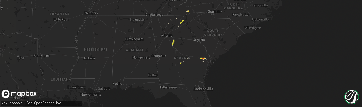
Hail Map in Georgia on April 9, 2019
The weather event in Georgia on April 9, 2019 includes Hail map. 6 states and 46 cities were impacted and suffered possible damage. The total estimated number of properties impacted is 11,357.
Hail
11,357
Estimated number of impacted properties by a 1.00" hail or larger563
Estimated number of impacted properties by a 1.75" hail or larger0
Estimated number of impacted properties by a 2.50" hail or largerStorm reports in Georgia
Georgia
| Date | Description |
|---|---|
| 04/09/20195:55 PM CDT | A social media post from broadcast media shows golf ball size hail. |
| 04/09/20194:57 PM CDT | Quarter-sized hail was reported at the dollar general in abbeville. |
| 04/09/20194:55 PM CDT | Public reported a tree was downed on brantley street nw. |
| 04/09/20194:55 PM CDT | Public reported a tree down on marietta rd nw near dupont commons lane. |
| 04/09/201912:08 PM CDT | Up to quarter sized hail reported by spotter east of toccoa... Ga. |
| 04/09/201912:02 PM CDT | Up to 1 inch hail reported ese of toccoa... Ga. |
| 04/09/201911:30 AM CDT | Report of a tree blown down just ssw of pinefield crossroads |
| 04/09/201911:20 AM CDT | Reports of 2 trees down 2 mi sse of homer |
| 04/09/20199:15 AM CDT | Update: report of 15-20 large trees down with 2 powerlines powerlines also down near the intersection of hwy 36 and fincher rd due to very strong straight line winds. |
| 04/09/20199:15 AM CDT | Reports of multiple trees down on power lines in the stewart glen subdivision |
| 04/09/20198:52 AM CDT | Quarter-sized hail reported at the flovilla fire department |
| 04/09/20197:44 AM CDT | At 1243 PM EDT, a severe thunderstorm was located 8 miles south of Toccoa, or 8 miles west of Avalon, moving northeast at 25 mph. HAZARD...60 mph wind gusts and quarter size hail. SOURCE...Radar indicated. IMPACT...Minor hail damage to vehicles is expected. Expect wind damage to trees and power lines. Locations impacted include... Toccoa, Carnesville, Westminster, Lavonia, Gumlog, Martin, Avalon, Tugaloo State Park, Long Creek and Oakway. |
| 04/09/20197:19 AM CDT | At 1218 PM EDT, a severe thunderstorm was located over Banks Crossing, moving northeast at 25 mph. HAZARD...60 mph wind gusts and quarter size hail. SOURCE...Radar indicated. IMPACT...Hail damage to vehicles is expected. Expect wind damage to roofs, siding, and trees. Locations impacted include... Commerce, Homer, Maysville, Pinefield Crossroads, Hollingsworth and Banks Crossing. |
| 04/09/20195:15 AM CDT | At 1014 AM EDT, a severe thunderstorm was located over North Alcovy, moving north at 30 mph. HAZARD...60 mph wind gusts and quarter size hail. SOURCE...Radar indicated. IMPACT...Hail damage to vehicles is expected. Expect wind damage to roofs, siding, and trees. Locations impacted include... Covington, Social Circle, Oxford, Porterdale, Newborn, Mansfield, Stewart, Turtle Cove, Almon, Starrsville, Brick Store, Calvin, Eudora, North Alcovy and Rocky Plains. |
| 04/09/20194:45 AM CDT | At 945 AM EDT, a severe thunderstorm was located over Flovilla, or near Jackson, moving north at 30 mph. HAZARD...60 mph wind gusts and quarter size hail. SOURCE...Radar indicated. IMPACT...Hail damage to vehicles is expected. Expect wind damage to roofs, siding, and trees. Locations impacted include... Jackson, Monticello, Porterdale, Newborn, Flovilla, Mansfield, Stewart, Turtle Cove, Worthville, Berner, Calvin, Farrar, Blount, Eudora, North Alcovy, McElheneys Crossroads, Juliette, Indian Springs State Park, Fincherville and Stark. |
| 04/09/201912:56 AM CDT | At 556 PM EDT, a severe thunderstorm was located over Abbeville, moving northeast at 25 mph. HAZARD...60 mph wind gusts and quarter size hail. SOURCE...Radar indicated. IMPACT...Hail damage to vehicles is expected. Expect wind damage to roofs, siding, and trees. Locations impacted include... Eastman, Abbeville, Rhine, Chauncey, Union, Jay Bird Springs, Browning, Five Points, Godwinsville, Ocmulgee Banks and Achord. |
| 04/08/20198:27 PM CDT | At 127 PM EDT, a severe thunderstorm was located 5 miles south of Walhalla, or near Westminster, moving northeast at 25 mph. HAZARD...60 mph wind gusts and quarter size hail. SOURCE...Radar indicated. IMPACT...Minor hail damage to vehicles is expected. Expect wind damage to trees and power lines. Locations impacted include... Clemson, Seneca, Walhalla, Central, Westminster, Norris, Six Mile, Salem, Lake Keowee and Oakway. |
All States Impacted by Hail Map on April 9, 2019
Cities Impacted by Hail Map on April 9, 2019
- Abbeville, GA
- Westminster, SC
- Eastanollee, GA
- Toccoa, GA
- Brooklet, GA
- Pembroke, GA
- Register, GA
- Claxton, GA
- Statesboro, GA
- Brevard, NC
- Geneva, FL
- Osteen, FL
- Oviedo, FL
- New Smyrna Beach, FL
- Ellabell, GA
- Covington, GA
- Forsyth, GA
- Monticello, GA
- Flovilla, GA
- Jackson, GA
- Dawsonville, GA
- Marble Hill, GA
- Howes Cave, NY
- Balsam Grove, NC
- Pisgah Forest, NC
- Commerce, GA
- Maysville, GA
- Homer, GA
- Guyton, GA
- Glenwood, GA
- Dahlonega, GA
- Ball Ground, GA
- Jasper, GA
- Esperance, NY
- Schoharie, NY
- Central Bridge, NY
- Suches, GA
- Lower Brule, SD
- Clarkesville, GA
- Talking Rock, GA
- Fort Stewart, GA
- Chauncey, GA
- Mansfield, GA
- Baldwin, GA
- Walhalla, SC
- Edgewater, FL


