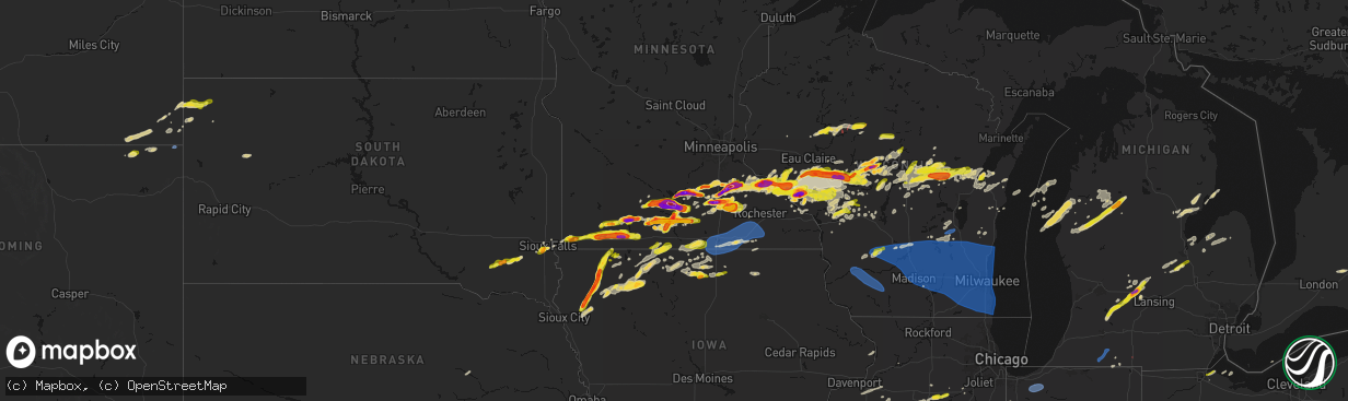
Hail Map on April 13, 2026
The weather event on April 13, 2026 includes Hail, Wind, and Tornado maps. 14 states and 902 cities were impacted and suffered possible damage. The total estimated number of properties impacted is 251,018.
Hail
Wind
Tornado
251,018
Estimated number of impacted properties by a 1.00" hail or larger71,444
Estimated number of impacted properties by a 1.75" hail or larger22,525
Estimated number of impacted properties by a 2.50" hail or largerStates Impacted by Hail Map on April 13, 2026
Storm reports
Texas
| Date | Description |
|---|---|
| 04/13/20266:45 PM CDT | Public report of ping pong ball sized hail in loraine received by media in abilene. |
| 04/13/20266:42 PM CDT | 40 mph winds. |
| 04/12/20268:02 PM CDT | Aspermont wtm gusted to 66 mph at 8:02 pm cdt... Gusted again to 65 mph at 8:03 pm. |
| 04/12/20267:32 PM CDT | We received a call from an individual in rotan... Tx reporting golf ball sized hail in rotan. He was located approximately one block west of the park in town. |
| 04/12/20267:32 PM CDT | Broadcast media relayed a photo of golf ball size hail from a viewer in rotan. Time of report estimated from radar. |
| 04/12/20267:26 PM CDT | West texas mesonet site |
| 04/12/20267:05 PM CDT | Media report |
Michigan
| Date | Description |
|---|---|
| 04/13/20266:50 PM CDT | Reports of quarter to half dollar sized hail from law enforcement and media. |
| 04/12/202611:50 PM CDT | A local report indicates 1.25 inch wind near 1 W Dighton |
| 04/12/202610:08 PM CDT | Mping report of half dollar sized hail |
| 04/12/20267:30 PM CDT | A local report indicates 2.00 inch wind near Portland |
| 04/12/20267:30 PM CDT | Quarter to ping pong sized hail from media reports and the public. |
| 04/12/20267:04 PM CDT | Report from mping: quarter |
South Dakota
| Date | Description |
|---|---|
| 04/13/20266:30 PM CDT | A local report indicates 1.00 inch wind near 4 SE Sioux Falls |
| 04/13/20266:25 PM CDT | A local report indicates 1.00 inch wind near 4 NNW Harrisburg |
| 04/13/20266:22 PM CDT | A local report indicates 1.00 inch wind near 3 NE Tea |
| 04/13/20266:22 PM CDT | A local report indicates 1.00 inch wind near 4 NE Tea |
| 04/13/20266:21 PM CDT | A local report indicates 1.25 inch wind near 4 NE Tea |
| 04/13/20266:20 PM CDT | Penny to quarter size hail. |
| 04/13/20266:18 PM CDT | A local report indicates 1.50 inch wind near 4 WSW Sioux Falls |
| 04/13/20266:14 PM CDT | A local report indicates 1.50 inch wind near Tea |
| 04/13/20266:13 PM CDT | A local report indicates 1.00 inch wind near 5 W Sioux Falls |
| 04/13/20264:40 PM CDT | A local report indicates 1.25 inch wind near 3 S Freeman |
| 04/13/20264:16 PM CDT | A local report indicates 1.00 inch wind near 5 NNE Olivet |
| 04/13/20264:00 PM CDT | A local report indicates 1.00 inch wind near 4 NW Olivet |
| 04/13/20263:40 PM CDT | A local report indicates 63 MPH wind near 8 NW Colony |
Iowa
| Date | Description |
|---|---|
| 04/13/20266:53 PM CDT | A local report indicates 1.00 inch wind near Melvin |
| 04/13/20266:50 PM CDT | Location estimated. |
| 04/13/20266:49 PM CDT | Time estimated by radar. |
| 04/13/20266:44 PM CDT | A local report indicates 1.50 inch wind near Sanborn |
| 04/13/20266:44 PM CDT | A local report indicates 1.50 inch wind near Sanborn |
| 04/13/20266:41 PM CDT | A local report indicates 1.25 inch wind near Sanborn |
| 04/13/20266:41 PM CDT | A local report indicates 1.25 inch wind near Sanborn |
| 04/13/20266:40 PM CDT | Via social media. |
| 04/13/20266:40 PM CDT | Report from mping: ping pong ball |
| 04/13/20266:40 PM CDT | Report from mping: ping pong ball |
| 04/13/20266:40 PM CDT | Report from mping: quarter |
| 04/13/20266:40 PM CDT | Report from mping: quarter |
| 04/13/20266:34 PM CDT | Social media report with picture of estimated hail size. |
| 04/13/20266:34 PM CDT | Social media report with picture of estimated hail size. |
| 04/13/20266:30 PM CDT | Corrects time of previous tornado report from 2 ne archer. Start of brief tornado which tracked generally north and northwest for around 5 minutes. Track was through op |
| 04/13/20266:30 PM CDT | Social media report with picture. Time estimated by radar. |
| 04/13/20266:30 PM CDT | Pea to quarter. |
| 04/13/20266:30 PM CDT | Social media report with a coin for reference. Time estimated by radar. |
| 04/13/20266:28 PM CDT | A local report indicates 1.00 inch wind near Primghar |
| 04/13/20266:28 PM CDT | A local report indicates 1.00 inch wind near Primghar |
| 04/13/20266:25 PM CDT | Spotter report of quarter inch hail with pictures. |
| 04/13/20266:10 PM CDT | A local report indicates 1.75 inch wind near 4 S Remsen |
| 04/13/20266:08 PM CDT | A local report indicates 1.75 inch wind near 4 SE Granville |
| 04/13/20266:08 PM CDT | A local report indicates 1.75 inch wind near 4 SE Granville |
| 04/13/20266:05 PM CDT | Time estimated from spotter/radar. |
| 04/13/20265:42 PM CDT | A local report indicates 2.75 inch wind near 5 SSW Remsen |
| 04/13/20265:37 PM CDT | A local report indicates 1.25 inch wind near 7 S Remsen |
| 04/13/20265:30 PM CDT | Start of brief tornado which tracked generally north and northwest for around 5 minutes. Track was through open fields with no visible damage. Location and track derive |
| 04/13/20265:30 PM CDT | Start of brief tornado which tracked generally north and northwest for around 5 minutes. Track was through open fields with no visible damage. Location and track derive |
| 04/12/202610:16 PM CDT | Dime to quarter sized hail at time of report. |
| 04/12/20269:45 PM CDT | A local report indicates 1.50 inch wind near 2 W Garner |
| 04/12/20267:58 PM CDT | A local report indicates 1.50 inch wind near 5 NE Webb |
| 04/12/20267:52 PM CDT | A local report indicates 1.00 inch wind near Webb |
| 04/12/20267:50 PM CDT | Photo of tornado from em. |
| 04/12/20267:50 PM CDT | Measured wind gust to 72 mph on a personal weather station due to rear flank downdraft to south of tornado path. Damage to trees... Shingles and siding. Some wind drive |
| 04/12/20267:24 PM CDT | Breif heavy rain and hail up to the size of quarters. |
Minnesota
| Date | Description |
|---|---|
| 04/13/20266:55 PM CDT | A local report indicates 2.50 inch wind near 2 ESE Hanska |
| 04/13/20266:54 PM CDT | Hail for about 5-10 minutes up to the size of ping pong balls... Most of them smaller. Moderate rain followed hail... And everything was done by about 715 pm. |
| 04/13/20266:50 PM CDT | A local report indicates 1.25 inch wind near Windom |
| 04/13/20266:46 PM CDT | Spotter report of golf ball sized hail. |
| 04/13/20266:45 PM CDT | A local report indicates 1.75 inch wind near 5 NW La Salle |
| 04/13/20266:45 PM CDT | A local report indicates 1.25 inch wind near 1 S Windom |
| 04/13/20266:45 PM CDT | A local report indicates 3.30 inch wind near Dennison |
| 04/13/20266:44 PM CDT | Report from mping: tennis ball |
| 04/13/20266:43 PM CDT | A local report indicates 1.00 inch wind near 6 S Fairmont |
| 04/13/20266:41 PM CDT | A local report indicates 1.50 inch wind near Hanska |
| 04/13/20266:40 PM CDT | A local report indicates 2.00 inch wind near 2 W Mountain Lake |
| 04/13/20266:34 PM CDT | Report from mping: golf ball |
| 04/13/20266:31 PM CDT | A local report indicates 1.50 inch wind near 3 SE Delft |
| 04/13/20266:26 PM CDT | A local report indicates 1.00 inch wind near 2 SE Wabasha |
| 04/13/20266:25 PM CDT | Updates previous tornado report from 7 wsw amboy. Multiple reports from storm chasers... Fire department... Law enforcement. Tornado still on ground at 632 pm. Farm out |
| 04/13/20266:25 PM CDT | Multiple reports from storm chasers... Fire department... Law enforcement. Tornado still on ground at 632 pm. |
| 04/13/20266:22 PM CDT | A local report indicates 1.00 inch wind near Delft |
| 04/13/20266:22 PM CDT | A local report indicates 1.50 inch wind near 1 NNE Wabasha |
| 04/13/20266:22 PM CDT | A local report indicates 1.00 inch wind near Wabasha |
| 04/13/20266:21 PM CDT | A local report indicates 2.00 inch wind near 4 N Windom |
| 04/13/20266:20 PM CDT | Social media report with pictures and ruler. |
| 04/13/20266:17 PM CDT | Report from mping: baseball |
| 04/13/20266:15 PM CDT | A local report indicates 2.00 inch wind near 5 NW Windom |
| 04/13/20266:13 PM CDT | Report from mping: tennis ball |
| 04/13/20266:12 PM CDT | Report from mping: ping pong ball |
| 04/13/20266:04 PM CDT | Report from mping: half dollar |
| 04/13/20266:04 PM CDT | A local report indicates 1.75 inch wind near Lewisville |
| 04/13/20266:03 PM CDT | Report from mping: quarter |
| 04/13/20266:00 PM CDT | A local report indicates 1.50 inch wind near 1 NNW Dundee |
| 04/13/20266:00 PM CDT | A local report indicates 2.00 inch wind near Lake City |
| 04/13/20265:59 PM CDT | A local report indicates 1.00 inch wind near 2 NW Dundee |
| 04/13/20265:59 PM CDT | Report from mping: quarter |
| 04/13/20265:54 PM CDT | A local report indicates 1.50 inch wind near 6 WSW Lewisville |
| 04/13/20265:52 PM CDT | Report from mping: hen egg |
| 04/13/20265:51 PM CDT | Report from mping: quarter |
| 04/13/20265:50 PM CDT | Mesonet station mn143 u.s.63 - lake city - mp 62.9. |
| 04/13/20265:50 PM CDT | A local report indicates 2.00 inch wind near 2 SSW Frontenac Station |
| 04/13/20265:48 PM CDT | A local report indicates 2.00 inch wind near 3 E Nicollet |
| 04/13/20265:45 PM CDT | A local report indicates 2.00 inch wind near 8 W Lake City |
| 04/13/20265:43 PM CDT | . |
| 04/13/20265:43 PM CDT | A local report indicates 2.50 inch wind near 4 ENE Bellechester |
| 04/13/20265:38 PM CDT | A local report indicates 1.75 inch wind near 2 N Ormsby |
| 04/13/20265:35 PM CDT | A local report indicates 1.75 inch wind near Odin |
| 04/13/20265:34 PM CDT | Report from mping: tennis ball |
| 04/13/20265:33 PM CDT | Report from mping: hen egg |
| 04/13/20264:45 PM CDT | Delayed report relayed with a photo via nwschat. |
| 04/13/20264:25 PM CDT | A local report indicates 1.50 inch wind near 2 NE Dennison |
| 04/13/20264:00 PM CDT | Reported relayed via slack. |
| 04/13/20263:57 PM CDT | Report from mping: quarter |
| 04/13/20263:56 PM CDT | Report from mping: ping pong ball |
| 04/13/20263:55 PM CDT | Report from mping: ping pong ball |
| 04/13/20263:53 PM CDT | A local report indicates 3.00 inch wind near 4 NNE Faribault |
| 04/13/20263:48 PM CDT | A local report indicates 2.00 inch wind near 4 NE Faribault |
| 04/13/20263:39 PM CDT | A local report indicates 1.50 inch wind near 1 SW Faribault |
| 04/13/20263:35 PM CDT | Egg sized hail reported via slack. Time estimated via radar. |
| 04/13/20263:27 PM CDT | Report from mping: ping pong ball |
| 04/13/20263:25 PM CDT | Corrects previous hail report from 2 wsw faribault. Egg sized hail reported via slack. Time estimated via radar. |
| 04/13/20263:25 PM CDT | A local report indicates 1.00 inch wind near 1 SW Faribault |
| 04/12/20269:47 PM CDT | A local report indicates 59 MPH wind near 1 NW Carimona |
| 04/12/20269:24 PM CDT | A local report indicates 58 MPH wind near 1 W Spring Valley |
| 04/12/20268:50 PM CDT | A local report indicates 1.00 inch wind near 1 N Jackson |
| 04/12/20268:49 PM CDT | A local report indicates 1.00 inch wind near 2 N Jackson |
| 04/12/20268:32 PM CDT | Lots of dime to quarter size hail. |
| 04/12/20268:29 PM CDT | Most hail stones were penny to quarter sized... But some as big as hen eggs. |
| 04/12/20268:28 PM CDT | A local report indicates 3.00 inch wind near Lake Crystal |
| 04/12/20268:21 PM CDT | A local report indicates 1.00 inch wind near 5 S Okabena |
| 04/12/20268:20 PM CDT | A local report indicates 1.25 inch wind near 5 S Okabena |
| 04/12/20268:09 PM CDT | Report from mping: ping pong ball |
| 04/12/20268:05 PM CDT | Trained spotter relayed tornado video via social media. Location and time estimated by radar. |
| 04/12/20268:05 PM CDT | Corrects previous tornado report from 3 ese matawan. Trained spotter relayed tornado video via social media. Location and time estimated by radar and from spotter damag |
| 04/12/20268:04 PM CDT | A local report indicates 1.50 inch wind near 5 W West Concord |
| 04/12/20267:46 PM CDT | A local report indicates 1.00 inch wind near 7 WNW Brewster |
| 04/12/20267:45 PM CDT | Report from mping: hen egg+ |
| 04/12/20267:40 PM CDT | Report from mping: quarter |
| 04/12/20267:39 PM CDT | A local report indicates 1.50 inch wind near 3 SSW Skyline |
| 04/12/20267:35 PM CDT | A local report indicates 1.00 inch wind near Goodhue |
| 04/12/20267:34 PM CDT | Time estimated from radar. |
| 04/12/20267:29 PM CDT | A local report indicates 1.50 inch wind near 6 NNE Rushmore |
| 04/12/20267:20 PM CDT | Tornado on video. Location and time approximate. |
| 04/12/20267:18 PM CDT | A local report indicates 2.00 inch wind near 6 WSW Lewisville |
| 04/12/20267:17 PM CDT | Report from mping: golf ball |
| 04/12/20267:16 PM CDT | A local report indicates 3.50 inch wind near Lake Crystal |
| 04/12/20267:15 PM CDT | A local report indicates 2.75 inch wind near 4 WNW Lake Crystal |
| 04/12/20267:15 PM CDT | Photo with measured hail. |
| 04/12/20267:15 PM CDT | A local report indicates 3.00 inch wind near Lake Crystal |
| 04/12/20267:10 PM CDT | A local report indicates 2.00 inch wind near 2 SW Judson |
| 04/12/20267:02 PM CDT | A local report indicates 2.75 inch wind near 4 N Madelia |
Illinois
| Date | Description |
|---|---|
| 04/13/20262:25 PM CDT | Report of a tree down and 3 power poles snapped at the base. Tree size unknown. Time estimated from radar. |
| 04/13/20262:21 PM CDT | Report of 2 power poles down. Relayed by em. Time estimated via radar. |
| 04/13/20262:04 PM CDT | Measured at pws kilbonfi13. |
| 04/13/20261:55 PM CDT | Spotter reports lots of pea sized hail but a few stones up to quarter size. |
Missouri
| Date | Description |
|---|---|
| 04/12/202610:38 PM CDT | Social media report of a downed tree at a residence in harrisonville. Time estimated from radar. |
| 04/12/202610:36 PM CDT | Report from mping: quarter |
| 04/12/202610:34 PM CDT | Public report and photo of quarter size hail in harrisonville. Time corrected from radar. |
| 04/12/202610:33 PM CDT | Private weather sensor. |
| 04/12/202610:27 PM CDT | Social media report of tree limbs down in calhoun. Time estimated from radar. |
| 04/12/202610:26 PM CDT | Report from mping: quarter |
| 04/12/202610:22 PM CDT | Weather station recorded 72 mph winds. Time estimated from radar. |
| 04/12/202610:15 PM CDT | Social media report. Time estimated from radar. |
| 04/12/202610:15 PM CDT | Social media report. Time estimated from radar. |
| 04/12/202610:10 PM CDT | Downed tree limbs and wires between county roads 211 and 221. Time estimated from radar. |
| 04/12/20269:52 PM CDT | Downed wires and power outages near timberline drive. Time estimated from radar. |
| 04/12/20269:45 PM CDT | Downed power lines near newton road. Time confirmed from radar. |
| 04/12/20269:40 PM CDT | Several reports of downed tree limbs and wires near garden city. Time estimated from radar. |
| 04/12/20269:40 PM CDT | Social media report of a power pole blown over and transformer blown from strong winds. Time estimated from radar. |
| 04/12/20269:38 PM CDT | Downed power pole near cumberland road. Time confirmed from radar. |
| 04/12/20269:35 PM CDT | Social media report of several large trees snapped or uprooted near route 131 south of odessa. Time estimated from radar. |
| 04/12/20269:32 PM CDT | Several large trees downed near newton road. Time estimated from radar. |
| 04/12/20269:20 PM CDT | Video shared on social media of power flash on storms... Looking to the sw. Time estimated from radar. |
| 04/12/20269:17 PM CDT | Downed trees and wires near 179th street. Time estimated from radar. |
| 04/12/20269:14 PM CDT | Social media report of trees down east of pleasant hill. Time estimated from radar. |
| 04/12/20269:14 PM CDT | Downed wires and power outages near south osborn road. Time estimated from radar. |
| 04/12/20269:13 PM CDT | Report of 60+ mph wind gusts with storm moving through... Magnitude estimated from radar. |
| 04/12/20269:11 PM CDT | Downed trees onto a vehicle in greenwood. Time estimated from radar. |
| 04/12/20269:11 PM CDT | Downed tree near route 7. Time estimated from radar. |
| 04/12/20269:11 PM CDT | Social media report of downed trees at a residence east of lees summit. Time estimated from radar. |
| 04/12/20269:10 PM CDT | Ripped siding from a house flew into a nearby property with minor damage. Time estimated from radar. |
| 04/12/20269:08 PM CDT | Several downed trees in greenwood. Time estimated from radar. |
| 04/12/20269:05 PM CDT | Social media report and photo of a downed tree at a residence near raintree lake. Time estimated from radar. |
| 04/12/20269:05 PM CDT | Minor property damage and tree limbs down in the stoney creek area. Time estimated from radar. |
| 04/12/20269:04 PM CDT | Significant damage at a property southwest of pleasant hill... With a metal building destroyed and several trees downed near a residence. Damage to a mobile home as wel |
| 04/12/20269:01 PM CDT | Social media report of downed trees and limbs near 155th and madison. Time estimated from radar. |
| 04/12/20269:01 PM CDT | Social media report of trees down in peculiar. Time estimated from radar. |
| 04/12/20269:00 PM CDT | Downed trees and damage to a garage and other property at a residence near peculiar. Time estimated from radar. |
| 04/12/20268:58 PM CDT | Downed tree limbs and wires near 218th forest scott avenue. Time estimated from radar. |
| 04/12/20268:58 PM CDT | Social media report of several downed trees at a residence near raymore. Time estimated from radar. |
| 04/12/20268:55 PM CDT | Em reported a tree down... Time estimated from radar. |
| 04/12/20268:52 PM CDT | Downed tree limbs near route 52 and route v. Time estimated from radar. |
| 04/12/20268:52 PM CDT | Public report of trees down near highway v. Time estimated from radar. |
| 04/12/20268:49 PM CDT | Downed wires and power outages near west line. Time estimated from radar. |
| 04/12/20268:49 PM CDT | Downed tree limbs and wires near and north of freeman. Time estimated from radar. |
| 04/12/20268:42 PM CDT | Corrects previous hail report from amoret. Social media report. Time estimated from radar. |
| 04/12/20268:37 PM CDT | Downed trees near the intersection of routes uu and m. Time estimated from radar. |
Ohio
| Date | Description |
|---|---|
| 04/12/20269:42 PM CDT | Buoy station faio1 fairport... Oh. |
| 04/12/20267:48 PM CDT | Large tree down across road in northern maumee. Police are on scene. |
| 04/12/20267:31 PM CDT | Thunderstorm wind gusts knocked down 6 power poles along n curtice rd north of state route 2. |
| 04/12/20267:21 PM CDT | A local report indicates 1.00 inch wind near Northwood |
| 04/12/20267:16 PM CDT | Shed damaged on county road 53 near mccomb. Time estimated via radar. |
Indiana
| Date | Description |
|---|---|
| 04/13/20263:43 PM CDT | Photo shared on social media of slightly larger-than-quarter sized hail east of the jasper county fairgrounds. Time estimated from radar. |
| 04/13/20263:20 PM CDT | Measured at kvpz. |
| 04/13/20263:14 PM CDT | Time estimated from radar. |
Wisconsin
| Date | Description |
|---|---|
| 04/13/20266:57 PM CDT | A local report indicates 1.00 inch wind near 6 SW Augusta |
| 04/13/20266:50 PM CDT | Time estimated via radar. |
| 04/13/20266:42 PM CDT | Report from mping: quarter |
| 04/13/20266:41 PM CDT | A local report indicates 1.75 inch wind near Osseo |
| 04/13/20266:40 PM CDT | A local report indicates 1.75 inch wind near Chili |
| 04/13/20266:37 PM CDT | A local report indicates 1.25 inch wind near 2 ESE Peru |
| 04/13/20266:35 PM CDT | A local report indicates 1.50 inch wind near 4 N Alma |
| 04/13/20266:35 PM CDT | A local report indicates 1.75 inch wind near 4 ENE Strum |
| 04/13/20266:34 PM CDT | A local report indicates 1.00 inch wind near Strum |
| 04/13/20266:28 PM CDT | A local report indicates 1.00 inch wind near Nelson |
| 04/13/20266:25 PM CDT | A local report indicates 1.25 inch wind near 1 NW Nelson |
| 04/13/20266:17 PM CDT | Tornado lifting and dropping onto the ground. |
| 04/13/20266:14 PM CDT | A local report indicates 1.50 inch wind near 1 NW Nelson |
| 04/13/20266:08 PM CDT | A local report indicates 1.25 inch wind near 5 NE Marshfield |
| 04/13/20266:06 PM CDT | A local report indicates 2.00 inch wind near 2 N Marshfield |
| 04/13/20266:00 PM CDT | Report from mping: half dollar |
| 04/13/20265:55 PM CDT | A local report indicates 1.00 inch wind near 1 E Wausau |
| 04/13/20265:55 PM CDT | A local report indicates 1.00 inch wind near Marshfield |
| 04/13/20265:43 PM CDT | A local report indicates 1.25 inch wind near 2 N Chili |
| 04/13/20265:40 PM CDT | A local report indicates 1.00 inch wind near 2 N Chili |
| 04/13/20265:26 PM CDT | A local report indicates 1.00 inch wind near 3 ESE Neillsville |
| 04/13/20265:25 PM CDT | A local report indicates 1.25 inch wind near 1 NNE Cornell |
| 04/13/20265:25 PM CDT | Report from mping: quarter |
| 04/13/20265:23 PM CDT | Report from mping: half dollar |
| 04/13/20265:17 PM CDT | A local report indicates 1.00 inch wind near Vesper |
| 04/13/20265:16 PM CDT | A local report indicates 1.00 inch wind near Neillsville |
| 04/13/20265:05 PM CDT | A local report indicates 1.00 inch wind near 1 SW Durand |
| 04/13/20264:34 PM CDT | A local report indicates 1.00 inch wind near Ellis |
| 04/13/20263:36 PM CDT | Report from mping: quarter |
| 04/13/20262:17 AM CDT | Trained spotter reports large oak tree snapped at base and fallen in road. |
| 04/13/20261:56 AM CDT | A total of six trees down across various portions of the county. One tree was down on a power line. Time estimated from radar. |
| 04/13/20261:55 AM CDT | Timmerman airport awos. |
| 04/13/20261:44 AM CDT | Social media reports of trees down and tree limbs down across southwestern milwaukee. Time estimated by radar. |
| 04/13/20261:40 AM CDT | Multiple social media reports of broken tree limbs and downed trees in northern and western milwaukee. Time estimated by radar. |
| 04/13/20261:40 AM CDT | Broadcast media reports large tree down on cars on the corner of 20th and west greenfield ave in milwaukee. Time estimated via radar. |
| 04/13/20261:39 AM CDT | Siding damage. |
| 04/13/20261:37 AM CDT | Concentrated area of trees and power lines down. Time estimated from radar. |
| 04/13/20261:30 AM CDT | Reports of trees down throughout the county. Time estimated from radar. |
| 04/13/20261:28 AM CDT | Several large trees down. |
| 04/13/20261:27 AM CDT | Several large trees uprooted or blown down. Some large trees fell on roofs of homes. Located in subdivision on corby drive and karin drive. Time estimated from radar. |
| 04/13/20261:24 AM CDT | Social media report with pictures of uprooted pine trees in lisbon. Time estimated by radar. |
| 04/13/20261:17 AM CDT | Widespread tree damage reported along the west side of lake okauchee. Report relayed by nws employee. Time estimated from radar. |
| 04/13/20261:17 AM CDT | A local report indicates 60 MPH wind near 4 SSE Sullivan |
| 04/13/20261:15 AM CDT | Large trees down on highway z and in surrounding areas. Time estimated from radar. |
| 04/13/20261:14 AM CDT | Trees down. |
| 04/13/20261:14 AM CDT | Large pine tree snapped about halfway up the trunk just north of intersection of highway f and ci. Time estimated from radar. |
| 04/13/20261:14 AM CDT | A local report indicates 60 MPH wind near 1 W Oconomowoc |
| 04/13/20261:10 AM CDT | Public report of widespread tree damage and small building damage between ashippun and erin. Time estimated by radar. |
| 04/13/20261:10 AM CDT | Trained spotter estimates 60 mph winds with dozens of trees downed... Uprooted... Or snapped. |
| 04/13/20261:07 AM CDT | A couple trees down. |
| 04/13/20261:04 AM CDT | Grouping of trees down. |
| 04/13/20261:01 AM CDT | Public report of multiple trees down across the south side of fort atkinson... As well as some roof damage. Time estimated by radar. |
| 04/13/20261:00 AM CDT | Scattered trees down throughout jefferson county between 12:46 am to 1:20 am. |
| 04/13/20261:00 AM CDT | A roof removed from a home on jackson street in jefferson. Some tree damage in the city. |
| 04/13/20261:00 AM CDT | Many trees down and uprooted... With one tree down on a house in the lee drive and aspen drive area. Time estimated from radar. |
| 04/13/202612:50 AM CDT | Countywide widespread tree and power line damage across dodge county from straight line winds. Time approximated via radar data. |
| 04/13/202612:44 AM CDT | North side of a wall of a barn was blown in... And the barn door on the south end of that barn was blown across the road and into a field. Time estimated from radar. |
| 04/13/202612:44 AM CDT | Garage and part of the roof that was attached to the home was blown away. Time estimated from radar. |
| 04/13/202612:38 AM CDT | Two large trees blown down. A pine tree snapped at 80 feet high. Additional tree branches down in area. |
| 04/13/202612:36 AM CDT | Public report of hollow oak tree 4 ft in diameter snapped at base. Time estimated by radar. |
| 04/13/202612:35 AM CDT | Broadcast media reports roof damage at the st. Joseph church in east bristol. Time estimated via radar data. |
| 04/13/202612:30 AM CDT | Trained spotter reports multiple trees down... With some tree fall on vehicles with damage. |
| 04/13/202612:30 AM CDT | Trained spotter reports numerous trees snapped off 10-15 feet off ground level. Tree fall caused damage to fiber glass roof of a shed. |
| 04/13/202612:26 AM CDT | Power poles and power lines down. A tree down on a house. |
| 04/13/202612:25 AM CDT | Garage door and a 1000 pound cattle ramp were thrown into a ditch at the alliant energy center. Time estimated from radar. |
| 04/13/202612:25 AM CDT | A credit union has an i beam through the side of the building. Time estimated from radar. |
| 04/13/202612:23 AM CDT | Multiple trees down near yahara elementary school. 1 fully uprooted and another snapped. |
| 04/13/202612:22 AM CDT | Report from mping: half dollar |
| 04/13/202612:20 AM CDT | Portions of a roof and beams lifted off a house. Images sent via facebook. Time estimated by radar. |
| 04/13/202612:19 AM CDT | One tree down near dalton. Time estimated from radar. |
| 04/13/202612:15 AM CDT | Several trees down throughout the county. Time estimated from radar. |
| 04/13/202612:15 AM CDT | Social media photo post of sheet metal roofing torn off of a dairy barn... As well as some sheet metal siding removed. |
| 04/13/202612:12 AM CDT | Roof collapse at a nursing home. Power lines and trees down. |
| 04/13/202612:10 AM CDT | Reports of trees twisted and down along with roof damage along delany street and dodgeville street in village of highland. Time estimated from radar. |
| 04/13/202612:06 AM CDT | Trees and power lines down. Trees on homes. |
| 04/13/202612:05 AM CDT | Corrects previous tstm wnd dmg report from 1 nnw prairie du sac. Trees and power lines down. Possible major roof damage at a factory. Tree down on a home. |
| 04/13/202612:05 AM CDT | Trained spotter reports snapped pine tree with fall occurring on a house. |
| 04/13/202612:05 AM CDT | Trees and power lines down. Minor roof damage to a couple buildings. |
| 04/12/202611:59 PM CDT | Barn collapsed and occupied with 30-40 cattle. |
| 04/12/202611:49 PM CDT | Trees and power lines down. |
| 04/12/202611:47 PM CDT | Sauk county sheriffs office reports part of the fire department roof torn off. Time estimated by radar. |
| 04/12/202611:46 PM CDT | Pole shed down in rock springs. |
| 04/12/202611:44 PM CDT | Public report of an outbuilding destroyed... As well as multiple trees down within the property. Time estimated by radar. |
| 04/12/202611:42 PM CDT | Trees and power lines down. |
| 04/12/202611:38 PM CDT | Shed removed from foundation. |
| 04/12/202610:05 PM CDT | A local report indicates 1.00 inch wind near 6 S Four Corners |
| 04/12/20269:23 PM CDT | A local report indicates 1.00 inch wind near Fort Mc Coy |
| 04/12/20269:23 PM CDT | Hailing at the time of the report. |
| 04/12/20268:39 PM CDT | A local report indicates 1.00 inch wind near 2 S Millston |
| 04/12/20268:15 PM CDT | A local report indicates 1.00 inch wind near Warrens |
| 04/12/20267:37 PM CDT | Quarter sized to half dollar sized hail. Corner of allard ave. And camm place. |
| 04/12/20267:35 PM CDT | A local report indicates 1.00 inch wind near 1 WNW Green Bay |
| 04/12/20267:35 PM CDT | A local report indicates 1.00 inch wind near 3 WNW Sidney |
| 04/12/20267:34 PM CDT | Report from mping: quarter |
| 04/12/20267:32 PM CDT | Report from mping: quarter |
| 04/12/20267:22 PM CDT | A local report indicates 1.75 inch wind near 7 WNW Humbird |
| 04/12/20267:15 PM CDT | A local report indicates 1.00 inch wind near 1 NW Clintonville |
| 04/12/20267:10 PM CDT | A local report indicates 2.00 inch wind near Humbird |
| 04/12/20267:03 PM CDT | Report made at 713pm after hail core had passed this location. Time of hailfall estimated from radar. |
Kansas
| Date | Description |
|---|---|
| 04/13/20266:35 PM CDT | A local report indicates 1.25 inch wind near Lyndon |
| 04/13/20266:32 PM CDT | A local report indicates 1.25 inch wind near 1 S Lyndon |
| 04/13/20266:30 PM CDT | A local report indicates 2.00 inch wind near 5 S Osage City |
| 04/13/20266:30 PM CDT | A local report indicates 2.00 inch wind near 5 S Osage City |
| 04/13/20266:05 PM CDT | Report from mping: hen egg |
| 04/13/20265:58 PM CDT | A local report indicates 1.25 inch wind near 4 W Reading |
| 04/13/20265:58 PM CDT | A local report indicates 1.75 inch wind near 4 W Reading |
| 04/13/20265:32 PM CDT | Emporia city manager reported quarter to half dollar size hail. |
| 04/13/20265:29 PM CDT | A local report indicates 1.00 inch wind near 4 SSE Americus |
| 04/13/20265:20 PM CDT | A local report indicates 1.00 inch wind near 3 NNE Saffordville |
| 04/13/20265:00 PM CDT | Relayed via social media with picture. |
| 04/13/20265:00 PM CDT | Reported via ksn-tv and law enforcement. |
| 04/13/20265:00 PM CDT | Corrects previous hail report from 6 n matfield green. Relayed via social media with picture. |
| 04/13/20264:55 PM CDT | A local report indicates 2.75 inch wind near 4 S Cottonwood Falls |
| 04/12/20269:38 PM CDT | Private weather sensor. |
| 04/12/20268:58 PM CDT | Downed tree limbs and wires near 263rd street. Time confirmed from radar. |
| 04/12/20268:44 PM CDT | Measured from mounted vehicle anemometer. Social media reports confirm damage in the area... With multiple trees downed... Roof damage to a property... And fence damage |
| 04/12/20268:42 PM CDT | Downed tree limbs and wires near 206th street. Time estimated from radar. |
| 04/12/20268:41 PM CDT | Downed trees and wires near rockville road. Time estimated from radar. |
| 04/12/20268:37 PM CDT | Private weather sensor. |
| 04/12/20268:36 PM CDT | Several social media reports of wind damage from the 215th and pflumm area... With multiple downed trees and minor property damage. Time estimated from radar. |
| 04/12/20268:36 PM CDT | Social media report of uprooted trees and several tree limbs down north of louisburg. Time estimated from radar. |
| 04/12/20268:36 PM CDT | Several reports of downed wires... Tree limbs... And power poles east of spring hill. Time estimated from radar. |
| 04/12/20268:33 PM CDT | Social media report of several trees downed east of webster and south of 215th. Time estimated from radar. |
| 04/12/20268:33 PM CDT | Social media report of severe damage to a chicken coop. Multiple trees down at the property as well. Time estimated from radar. |
| 04/12/20268:30 PM CDT | Social media report of a damaged outbuilding and fence at a residence as well as multiple trees downed. Time estimated from radar. |
| 04/12/20268:30 PM CDT | Multiple trees and fence posts downed as well as property damage to multiple residences near main street. Time estimated from radar. |
| 04/12/20268:30 PM CDT | Spotter reported a tornado crossing the road just south of pleasanton. |
| 04/12/20268:29 PM CDT | Downed tree limbs and wires near route 52. Possible tornado damage. Time confirmed from radar. |
| 04/12/20268:27 PM CDT | Several trees down with property damage near south street. Time estimated from radar. |
| 04/12/20268:27 PM CDT | Downed tree limbs and wires near foster street. Time estimated from radar. |
| 04/12/20268:24 PM CDT | Downed wires and power outages near 223rd street. Time estimated from radar. |
| 04/12/20268:23 PM CDT | Downed wires and power outages near clare road. Time estimated from radar. |
| 04/12/20268:22 PM CDT | Downed wires near 207th street. Time estimated from radar. |
| 04/12/20268:20 PM CDT | *** 1 inj *** shortly before 820 pm cdt on monday april 13th... 2026... A supercell thunderstorm... That had previously resulted in an ef- 2 tornado in ottawa... Ks... |
| 04/12/20268:20 PM CDT | Damage in spring hill reported by em. Several trees and power poles down. Time estimated by radar. |
| 04/12/20268:19 PM CDT | *** 2 inj *** corrects previous tornado report from 2 se mound city. Around 8 pm on 13 april 2026... An ef-1 tornado associated with a supercell developed in far southw |
| 04/12/20268:18 PM CDT | Photo shared of a tornado on the ground... Looking northwest at the storm by a spotter. |
| 04/12/20268:18 PM CDT | Downed wires near farm lane. Time estimated from radar. |
| 04/12/20268:16 PM CDT | Social media photo shows a tornado on the ground... Location is approximately sw of spring hill. |
| 04/12/20268:09 PM CDT | A brief tornado was observed via videos taken by a drone and storm spotters north of the much longer track tornado. Location was estimated via video evidence and radar |
| 04/12/20268:09 PM CDT | Reported roping out tornado as storm passed through blue mound. |
| 04/12/20268:08 PM CDT | Downed trees and wires near route 31. Possible tornado damage. Time estimated from radar. |
| 04/12/20268:02 PM CDT | Downed wires near 350th road. Time estimated from radar. |
| 04/12/20267:49 PM CDT | Downed wires near waverly road. Time estimated from radar. |
| 04/12/20267:42 PM CDT | A local report indicates 2.75 inch wind near 1 N Ottawa |
| 04/12/20267:38 PM CDT | Observed moving east. |
| 04/12/20267:35 PM CDT | Reports of damage in southern ottawa... On main street between 15th and 23rd... Including wall and rood damage to a hotel... Roof damage and wall down at a gas station. |
| 04/12/20267:35 PM CDT | Damage to the roof and a wall of the t-mobile store on south main street in ottawa. |
| 04/12/20267:30 PM CDT | Delayed report of 2 inch hail stones across the street from ottawa high school. Photos sent via email. |
| 04/12/20267:15 PM CDT | Spotter confirmed he was seeing debris but is about 15 miles south so can not fully see the actual tornado. |
| 04/12/20267:10 PM CDT | Hail was observed on the ground behind the storm. |
| 04/12/20267:07 PM CDT | Delayed report. Storm chaser reported a tornado occurred just southwest of town. Was on the ground approximately two minutes and damaged a sheet metal shed. |
Cities Impacted by Hail Map on April 13, 2026
- Hamilton, IL
- Nauvoo, IL
- Bradford, IL
- Wyoming, IL
- Henry, IL
- Sparland, IL
- Clinton, IA
- Bryant, IA
- Wenona, IL
- Putnam, IL
- Streator, IL
- Magnolia, IL
- Lacon, IL
- Hennepin, IL
- Sabula, IA
- McNabb, IL
- Granville, IL
- Sterling, IL
- Peru, IL
- Standard, IL
- Oglesby, IL
- Ottawa, IL
- Cabery, IL
- Dwight, IL
- Buckingham, IL
- Odell, IL
- Emington, IL
- Campus, IL
- Utica, IL
- Marseilles, IL
- Reddick, IL
- Herscher, IL
- Gardner, IL
- Union Hill, IL
- Bonfield, IL
- Essex, IL
- Wilmington, IL
- Kankakee, IL
- Chebanse, IL
- Martinton, IL
- Saint Anne, IL
- Papineau, IL
- Beaverville, IL
- Weston, WY
- Grant Park, IL
- Momence, IL
- Broadus, MT
- Hammond, MT
- Bourbonnais, IL
- Moorcroft, WY
- Hulett, WY
- Lowell, IN
- Alzada, MT
- Watseka, IL
- Donovan, IL
- Dryden, TX
- Hillpoint, WI
- Loganville, WI
- La Valle, WI
- Lime Ridge, WI
- Reedsburg, WI
- Morocco, IN
- Richland Center, WI
- Pembroke Township, IL
- Cazenovia, WI
- Faribault, MN
- Capitol, MT
- Northfield, MN
- Nerstrand, MN
- Fort Stockton, TX
- Ekalaka, MT
- Dennison, MN
- Rensselaer, IN
- Fair Oaks, IN
- Mount Ayr, IN
- Kenyon, MN
- Cannon Falls, MN
- Tripp, SD
- Olivet, SD
- Baraboo, WI
- Camp Crook, SD
- Goodhue, MN
- Portage, WI
- Burns, KS
- Menno, SD
- Freeman, SD
- Cedar Point, KS
- Anson, TX
- Red Wing, MN
- Welch, MN
- Stevens Point, WI
- Stockholm, WI
- Pepin, WI
- Buffalo, SD
- Midkiff, TX
- Sweetwater, TX
- Roby, TX
- Sylvester, TX
- McCaulley, TX
- Custer, WI
- Rosholt, WI
- Cottonwood Falls, KS
- Hatley, WI
- Howe, IN
- Plum City, WI
- Spencer, WI
- Loyal, WI
- Granton, WI
- Wittenberg, WI
- Eland, WI
- Sturgis, MI
- Neillsville, WI
- Marshfield, WI
- Big Lake, TX
- Maiden Rock, WI
- Nelson, WI
- Strong City, KS
- Durand, WI
- Marion, SD
- Constantine, MI
- Three Rivers, MI
- Emporia, KS
- Centreville, MI
- Mendon, MI
- Bowler, WI
- Burr Oak, MI
- Merrillan, WI
- Wisconsin Rapids, WI
- Pittsville, WI
- Stratford, WI
- Tigerton, WI
- Vesper, WI
- Hamlin, TX
- Haskell, TX
- Wheeler, WI
- Weinert, TX
- Chili, WI
- Garden City, TX
- Eleva, WI
- Strum, WI
- Kingsley, IA
- Moville, IA
- Cornell, WI
- Bronson, MI
- Birnamwood, WI
- Parker, SD
- Holcombe, WI
- Odin, MN
- Lake City, MN
- Humbird, WI
- Bloomer, WI
- Lonsdale, MN
- New Prague, MN
- Zumbrota, MN
- Montgomery, MN
- Kilkenny, MN
- Throckmorton, TX
- Americus, KS
- Arpin, WI
- Sterling City, TX
- Columbia City, IN
- Roanoke, IN
- Fort Wayne, IN
- Arcola, IN
- Gilman, WI
- Saint James, MN
- Butterfield, MN
- Ormsby, MN
- Union Center, SD
- Nicollet, MN
- Le Mars, IA
- Remsen, IA
- Hinton, IA
- Marathon, WI
- Mosinee, WI
- Mondovi, WI
- Rudolph, WI
- Fulda, MN
- Mankato, MN
- Boyd, WI
- Osseo, WI
- Frontenac, MN
- Marcus, IA
- Stamford, TX
- Reading, KS
- Saint Peter, MN
- Sheldon, WI
- Wausau, WI
- Lewisville, MN
- Ruthven, IA
- Dickens, IA
- Pierson, IA
- Le Center, MN
- Seymour, TX
- Heron Lake, MN
- Comfrey, MN
- Darfur, MN
- Estherville, IA
- Granville, IA
- Paullina, IA
- Avoca, TX
- Medford, WI
- Sioux Falls, SD
- Tea, SD
- Lennox, SD
- Kasota, MN
- Ossian, IN
- Yoder, IN
- Decatur, IN
- Hoagland, IN
- Monroeville, IN
- New Haven, IN
- Woodburn, IN
- Grabill, IN
- Wabasha, MN
- Reads Landing, MN
- Amboy, MN
- Truman, MN
- Vernon Center, MN
- Hanska, MN
- Sleepy Eye, MN
- Auburndale, WI
- Webster, MN
- Windom, MN
- Edgar, WI
- Plainwell, MI
- Armstrong, IA
- Schofield, WI
- Dundas, MN
- Plover, WI
- Osage City, KS
- Westboro, WI
- Archer, IA
- Graettinger, IA
- Cleveland, MN
- Amherst Junction, WI
- Amherst, WI
- Scandinavia, WI
- Nelsonville, WI
- Iola, WI
- Convoy, OH
- Antwerp, OH
- Payne, OH
- Paulding, OH
- Scott, OH
- Haviland, OH
- Cecil, OH
- Alma, WI
- Fall Creek, WI
- Kellogg, MN
- Westbrook, TX
- Melvin, IA
- Ocheyedan, IA
- Arkansaw, WI
- Delton, MI
- Council Grove, KS
- Dolliver, IA
- Emmetsburg, IA
- Valley Springs, SD
- Fountain City, WI
- Cochrane, WI
- Elmdale, KS
- Loraine, TX
- Colorado City, TX
- Lyndon, KS
- Sanborn, IA
- Primghar, IA
- Vassar, KS
- Hastings, MI
- Grover Hill, OH
- Cloverdale, OH
- Oakwood, OH
- Latty, OH
- Melrose, OH
- Defiance, OH
- Good Thunder, MN
- Madelia, MN
- Roscoe, TX
- Whitehall, WI
- Altura, MN
- Morristown, MN
- Waseca, MN
- Brandon, SD
- Chancellor, SD
- Admire, KS
- Cleghorn, IA
- Bingham Lake, MN
- Mountain Lake, MN
- Augusta, WI
- Janesville, MN
- Allen, KS
- Beaver Creek, MN
- Milladore, WI
- Madison Lake, MN
- Lake Park, IA
- Harris, IA
- Arcadia, WI
- Hartford, SD
- Fairchild, WI
- Cherokee, IA
- Meriden, IA
- Spencer, IA
- Royal, IA
- Fairmont, MN
- Wallingford, IA
- Ceylon, MN
- Lebo, KS
- Melvern, KS
- Lake Crystal, MN
- Quenemo, KS
- Waterville, MN
- Elysian, MN
- Ashton, IA
- Sibley, IA
- Medford, MN
- Owatonna, MN
- Alma Center, WI
- Marion, WI
- Manawa, WI
- Ogdensburg, WI
- Hartley, IA
- Junction City, WI
- Larrabee, IA
- Independence, WI
- Peterson, IA
- Athens, WI
- Mapleton, MN
- Swea City, IA
- Granada, MN
- Humboldt, KS
- Ringsted, IA
- Springfield, MN
- Terril, IA
- Milford, IA
- Luverne, MN
- Eskridge, KS
- Piqua, KS
- Bear Creek, WI
- Clintonville, WI
- Continental, OH
- Freeport, MI
- Woodland, MI
- Lake Odessa, MI
- Vermontville, MI
- Hermleigh, TX
- Stanley, WI
- Willard, WI
- Garden City, MN
- New London, WI
- Spalding, NE
- New Ulm, MN
- Spirit Lake, IA
- Arnolds Park, IA
- Winnebago, MN
- Hixton, WI
- Scranton, KS
- Burlingame, KS
- Magnolia, MN
- Iola, KS
- Elmore, MN
- Blue Earth, MN
- Pomona, KS
- Sutherland, IA
- Embarrass, WI
- Aurelia, IA
- Linn Grove, IA
- Overbrook, KS
- Everly, IA
- Sunfield, MI
- Portland, MI
- Ottawa, KS
- Minnesota Lake, MN
- Shiocton, WI
- Blair, WI
- Ettrick, WI
- Ledyard, IA
- Rushmore, MN
- Rotan, TX
- Adrian, MN
- Merrill, WI
- La Harpe, KS
- Moran, KS
- Wanamingo, MN
- Primrose, NE
- Oregon, OH
- Carbondale, KS
- McComb, OH
- Lismore, MN
- Wilmont, MN
- Westphalia, MI
- Pewamo, MI
- Williamsburg, KS
- Waldorf, MN
- Green Bay, WI
- Kincaid, KS
- Blue Mound, KS
- Claremont, MN
- West Concord, MN
- Reading, MN
- Burt, IA
- Lone Rock, IA
- Taylor, WI
- Webb, IA
- Sioux Rapids, IA
- Greenville, IA
- De Pere, WI
- Buffalo Center, IA
- Mazeppa, MN
- Oneida, WI
- Bonduel, WI
- Black Creek, WI
- Baldwin City, KS
- Curtice, OH
- Greenwood, WI
- Bancroft, IA
- Fenton, IA
- Bronson, KS
- Galesville, WI
- Seymour, WI
- Caroline, WI
- Leopolis, WI
- Pemberton, MN
- Worthington, MN
- Brewster, MN
- Melrose, WI
- Black River Falls, WI
- Lawrence, KS
- Saint Johns, MI
- Fowler, MI
- Pulaski, WI
- Hewitt, WI
- New Franken, WI
- Millbury, OH
- Frost, MN
- Bricelyn, MN
- Rake, IA
- Thompson, IA
- Ayrshire, IA
- Gillett Grove, IA
- Titonka, IA
- Aspermont, TX
- Eagle, MI
- Grand Ledge, MI
- Wellsville, KS
- Trimont, MN
- Lyons, MI
- Luxemburg, WI
- Round Lake, MN
- Hospers, IA
- Dodge Center, MN
- Shawano, WI
- Toledo, OH
- Rantoul, KS
- Paola, KS
- Edgerton, KS
- Wells, MN
- Kiester, MN
- Eagle Lake, MN
- Millville, MN
- Mound City, KS
- Okabena, MN
- Curlew, IA
- Spring Hill, KS
- Laurens, IA
- Delavan, MN
- Zumbro Falls, MN
- Warsaw, MN
- Scarville, IA
- Lakefield, MN
- Emmons, MN
- Alden, MN
- Louisburg, KS
- Bucyrus, KS
- Sparta, WI
- Pine Island, MN
- Gardner, KS
- Pleasanton, KS
- Suamico, WI
- Twin Lakes, MN
- Hayward, MN
- Glenville, MN
- Northwood, IA
- Albert Lea, MN
- Lake Mills, IA
- Conger, MN
- Eudora, KS
- Hollandale, MN
- Austin, MN
- Old Glory, TX
- Cleveland, MO
- Stilwell, KS
- Lyle, MN
- Saint Ansgar, IA
- Foster, MO
- Tomah, WI
- Warrens, WI
- Bangor, WI
- Mindoro, WI
- Oakley, MI
- Chesaning, MI
- Mantorville, MN
- Amoret, MO
- Belton, MO
- Jackson, MN
- Lansing, MN
- Waltham, MN
- Rose Creek, MN
- Brownsdale, MN
- Peculiar, MO
- Freeman, MO
- Butler, MO
- Raymore, MO
- Pleasant Hill, MO
- Kansas City, MO
- Grandview, MO
- Lees Summit, MO
- Greenwood, MO
- Hayfield, MN
- Blooming Prairie, MN
- Kasson, MN
- Sargeant, MN
- Byron, MN
- Dexter, MN
- Elkton, MN
- Adams, MN
- Grand Meadow, MN
- Stewartville, MN
- Saint Charles, MI
- Montrose, MI
- Joice, IA
- Woden, IA
- Burt, MI
- Birch Run, MI
- Saginaw, MI
- Bridgeport, MI
- Alpha, MN
- Kingsville, MO
- Strasburg, MO
- Lone Jack, MO
- Wesley, IA
- Nekoosa, WI
- Port Edwards, WI
- Nichols, WI
- Minnesota City, MN
- Forest City, IA
- Britt, IA
- Warrensburg, MO
- Holden, MO
- Centerview, MO
- Bates City, MO
- Odessa, MO
- Oak Grove, MO
- Mayview, MO
- Higginsville, MO
- Wellington, MO
- Lexington, MO
- Grain Valley, MO
- Garner, IA
- Denmark, WI
- Greenleaf, WI
- Camp Douglas, WI
- Winona, MN
- Bancroft, WI
- Plainfield, WI
- Kewaunee, WI
- Necedah, WI
- Trempealeau, WI
- Norwalk, WI
- Friendship, WI
- Almond, WI
- Caro, MI
- Vassar, MI
- Reese, MI
- Fairgrove, MI
- Waupaca, WI
- Leland, IA
- Crystal Lake, IA
- Ventura, IA
- Fertile, IA
- Clear Lake, IA
- Weyauwega, WI
- Holmen, WI
- Cass City, MI
- Standish, MI
- Bentley, MI
- Urich, MO
- Blairstown, MO
- Clinton, MO
- Chilhowee, MO
- Arkdale, WI
- Waverly, MO
- Alma, MO
- Concordia, MO
- Corder, MO
- Malta Bend, MO
- Blackburn, MO
- Carrollton, MO
- Sweet Springs, MO
- Miami, MO
- Knob Noster, MO
- Marshall, MO
- Calhoun, MO
- Windsor, MO
- Harrisonville, MO
- Omer, MI
- Au Gres, MI
- Hancock, WI
- Mason City, IA
- Lanesboro, MN
- Sterling, MI
- Lincoln, MO
- Warsaw, MO
- Walkerville, MI
- Hart, MI
- Twining, MI
- Turner, MI
- Ludington, MI
- Whittemore, MI
- East Lynne, MO
- Wautoma, WI
- Free Soil, MI
- Manistee, MI
- Scottville, MI
- Garden City, MO
- National City, MI
- Tawas City, MI
- New Lisbon, WI
- Branch, MI
- Bitely, MI
- Cole Camp, MO
- Baldwin, MI
- Idlewild, MI
- Charles City, IA
- Ripon, WI
- Pickett, WI
- Edwards, MO
- Stover, MO
- Gravois Mills, MO
- Versailles, MO
- Eldorado, WI
- Oshkosh, WI
- McIntire, IA
- Riceville, IA
- Manitowoc, WI
- Reedsville, WI
- Chase, MI
- Reed City, MI
- Colwell, IA
- Ionia, IA
- Alta Vista, IA
- Luther, MI
- Leroy, MI
- Tustin, MI
- Glenbeulah, WI
- Plymouth, WI
- Wellston, MI
- Le Roy, MN
- Chester, IA
- Marion, MI
- McBain, MI
- Cadillac, MI
- Sheboygan Falls, WI
- Boon, MI
- Harrietta, MI
- Ionia, MI
- Cambria, WI
- Markesan, WI
- Randolph, WI
- Muir, MI
- Mesick, MI
- Orleans, MI
- Fenwick, MI
- Waupun, WI
- Brandon, WI
- Stoughton, WI
- Rosendale, WI
- Taopi, MN
- Fox Lake, WI
- Oakfield, WI
- Irons, MI
- Harrison, MI
- Gladwin, MI
- Brant, MI
- Fountain, MI
- Ashley, MI
- Coon Valley, WI
- Higbee, MO
- Huntsville, MO
- Lannon, WI
- Menomonee Falls, WI
- Sussex, WI
- Moberly, MO
- Madison, MO
- Jacksonville, MO
- Cairo, MO
- Bay City, MI
- Munger, MI
- Essexville, MI
- Waukesha, WI
- Pewaukee, WI
- Brookfield, WI
- Elm Grove, WI
- Milwaukee, WI
- Akron, MI
- Unionville, MI
- Atlanta, MO
- Sebewaing, MI
- Clarence, MO
- Excello, MO
- Leonard, MO
- Owendale, MI
- Gagetown, MI
- Shelbina, MO
- Bethel, MO
- Novelty, MO
- Shelbyville, MO
- Edina, MO
- Rutledge, MO
- Hurdland, MO
- Newark, MO
- Knox City, MO
- Hunnewell, MO
- Paris, MO
- Lewistown, MO
- La Belle, MO
- Palmyra, MO
- Monroe City, MO
- Ewing, MO
- Wyaconda, MO
- Kahoka, MO
- Williamstown, MO
- Saint Patrick, MO
- Monticello, MO
- Quincy, IL
- Barnett, MO
- Camp Point, IL
- Fowler, IL
- Orion, IL
- Osco, IL
- Rothschild, WI
- Geneseo, IL
- Atkinson, IL
- Ostrander, MN
- Spring Valley, MN
- Racine, MN
- Oconomowoc, WI
- Hartland, WI
- Nashotah, WI
- Okauchee, WI
- Sullivan, WI
- Jefferson, WI
- Delafield, WI
- Watertown, WI
- Helenville, WI
- Johnson Creek, WI
- Fort Atkinson, WI
- Dousman, WI
- Palmyra, WI
- Wales, WI
- Eagle, WI
- North Prairie, WI
- Mukwonago, WI
- New Berlin, WI
- Butler, WI
- Mendota, IL
- Troy Grove, IL
- Kewanee, IL
- Toulon, IL
- Neponset, IL
- Morris, IL
- Tonica, IL
- Lostant, IL
- Waunakee, WI
- Middleton, WI
- Cross Plains, WI
- Green Ridge, MO
- Sedalia, MO
- Ionia, MO
- Mora, MO
- Smithton, MO
- Fortuna, MO
- Florence, MO
- Lake Mills, WI
- Cambridge, WI
- Waterloo, WI
- Cottage Grove, WI
- Deerfield, WI
- Marshall, WI
- Sun Prairie, WI
- Madison, WI
- Deforest, WI
- Windsor, WI
- Arlington, WI
- Lodi, WI
- Dane, WI
- Morrisonville, WI
- Columbus, WI
- Rio, WI
- Poynette, WI
- Merrimac, WI
- North Freedom, WI
- Pardeeville, WI
- Ubly, MI
- Bad Axe, MI
- Rock Springs, WI
- Wisconsin Dells, WI
- Wyocena, WI
- Doylestown, WI
- Fall River, WI
- Juneau, WI
- Burnett, WI
- Beaver Dam, WI
- Lowell, WI
- Reeseville, WI
- Iron Ridge, WI
- Horicon, WI
- Allenton, WI
- Rubicon, WI
- Mayville, WI
- Neosho, WI
- Clyman, WI
- Hustisford, WI
- Hartford, WI
- Lebanon, WI
- Jackson, WI
- Slinger, WI
- Richfield, WI
- West Bend, WI
- Ixonia, WI
- Ashippun, WI
- Germantown, WI
- Mequon, WI
- Cedarburg, WI
- Colgate, WI
- Hubertus, WI
- Friesland, WI
- Theresa, WI
- Lomira, WI
- Brownsville, WI
- Campbellsport, WI
- Kewaskum, WI
- Fredonia, WI
- Random Lake, WI
- Cedar Grove, WI
- Port Washington, WI
- Grafton, WI
- Belgium, WI
- Saukville, WI
- Prairie Du Sac, WI
- Sauk City, WI
- Mazomanie, WI
- Oregon, WI
- Mcfarland, WI
- Edgerton, WI
- Whitewater, WI
- East Troy, WI
- Elkhorn, WI
- Burlington, WI
- Waterford, WI
- Big Bend, WI
- Salem, WI
- Kansasville, WI
- Rochester, WI
- Kenosha, WI
- Muskego, WI
- Union Grove, WI
- Bristol, WI
- Sturtevant, WI
- Franksville, WI
- Pleasant Prairie, WI
- Caledonia, WI
- Franklin, WI
- Racine, WI
- Oak Creek, WI
- Greendale, WI
- Hales Corners, WI
- South Milwaukee, WI
- Cudahy, WI
- Saint Francis, WI
- Plain, WI
- Olathe, KS
- Overland Park, KS
- Dover, MO
- Dodgeville, WI
- Blue River, WI
- Hollandale, WI
- Mineral Point, WI
- Avoca, WI
- Muscoda, WI
- Cobb, WI
- Highland, WI
- Boscobel, WI
- Brook, IN
- Union Mills, IN
- Wanatah, IN
- Westville, IN
- Hanna, IN
- Valparaiso, IN
- Fond Du Lac, WI
- Kenneth, MN
- Coldwater, MI
- New Richland, MN