Hail Map in Iowa on April 13, 2026
The weather event in Iowa on April 13, 2026 includes Hail, Wind, and Tornado maps. 14 states and 902 cities were impacted and suffered possible damage. The total estimated number of properties impacted is 19,623.
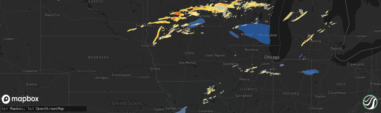
Hail
Wind
Tornado
19,623
Estimated number of impacted properties by a 1.00" hail or larger2,049
Estimated number of impacted properties by a 1.75" hail or larger787
Estimated number of impacted properties by a 2.50" hail or largerStorm reports in Iowa
Iowa
| Date | Description |
|---|---|
| 04/13/20266:53 PM CDT | A local report indicates 1.00 inch wind near Melvin |
| 04/13/20266:50 PM CDT | Location estimated. |
| 04/13/20266:49 PM CDT | Time estimated by radar. |
| 04/13/20266:44 PM CDT | A local report indicates 1.50 inch wind near Sanborn |
| 04/13/20266:44 PM CDT | A local report indicates 1.50 inch wind near Sanborn |
| 04/13/20266:41 PM CDT | A local report indicates 1.25 inch wind near Sanborn |
| 04/13/20266:41 PM CDT | A local report indicates 1.25 inch wind near Sanborn |
| 04/13/20266:40 PM CDT | Report from mping: ping pong ball |
| 04/13/20266:40 PM CDT | Report from mping: ping pong ball |
| 04/13/20266:40 PM CDT | Via social media. |
| 04/13/20266:40 PM CDT | Report from mping: quarter |
| 04/13/20266:40 PM CDT | Report from mping: quarter |
| 04/13/20266:34 PM CDT | Social media report with picture of estimated hail size. |
| 04/13/20266:34 PM CDT | Social media report with picture of estimated hail size. |
| 04/13/20266:30 PM CDT | Pea to quarter. |
| 04/13/20266:30 PM CDT | Social media report with picture. Time estimated by radar. |
| 04/13/20266:30 PM CDT | Social media report with a coin for reference. Time estimated by radar. |
| 04/13/20266:30 PM CDT | Corrects time of previous tornado report from 2 ne archer. Start of brief tornado which tracked generally north and northwest for around 5 minutes. Track was through op |
| 04/13/20266:28 PM CDT | A local report indicates 1.00 inch wind near Primghar |
| 04/13/20266:28 PM CDT | A local report indicates 1.00 inch wind near Primghar |
| 04/13/20266:25 PM CDT | Spotter report of quarter inch hail with pictures. |
| 04/13/20266:10 PM CDT | A local report indicates 1.75 inch wind near 4 S Remsen |
| 04/13/20266:08 PM CDT | A local report indicates 1.75 inch wind near 4 SE Granville |
| 04/13/20266:08 PM CDT | A local report indicates 1.75 inch wind near 4 SE Granville |
| 04/13/20266:05 PM CDT | Time estimated from spotter/radar. |
| 04/13/20265:42 PM CDT | A local report indicates 2.75 inch wind near 5 SSW Remsen |
| 04/13/20265:37 PM CDT | A local report indicates 1.25 inch wind near 7 S Remsen |
| 04/13/20265:30 PM CDT | Start of brief tornado which tracked generally north and northwest for around 5 minutes. Track was through open fields with no visible damage. Location and track derive |
| 04/13/20265:30 PM CDT | Start of brief tornado which tracked generally north and northwest for around 5 minutes. Track was through open fields with no visible damage. Location and track derive |
| 04/12/202610:16 PM CDT | Dime to quarter sized hail at time of report. |
| 04/12/20269:45 PM CDT | A local report indicates 1.50 inch wind near 2 W Garner |
| 04/12/20267:58 PM CDT | A local report indicates 1.50 inch wind near 5 NE Webb |
| 04/12/20267:52 PM CDT | A local report indicates 1.00 inch wind near Webb |
| 04/12/20267:50 PM CDT | Measured wind gust to 72 mph on a personal weather station due to rear flank downdraft to south of tornado path. Damage to trees... Shingles and siding. Some wind drive |
| 04/12/20267:50 PM CDT | Photo of tornado from em. |
| 04/12/20267:24 PM CDT | Breif heavy rain and hail up to the size of quarters. |
All States Impacted by Hail Map on April 13, 2026
Cities Impacted by Hail Map on April 13, 2026
- Hamilton, IL
- Nauvoo, IL
- Bradford, IL
- Wyoming, IL
- Henry, IL
- Sparland, IL
- Clinton, IA
- Bryant, IA
- Wenona, IL
- Putnam, IL
- Streator, IL
- Magnolia, IL
- Lacon, IL
- Hennepin, IL
- Sabula, IA
- McNabb, IL
- Granville, IL
- Sterling, IL
- Peru, IL
- Standard, IL
- Oglesby, IL
- Ottawa, IL
- Cabery, IL
- Dwight, IL
- Buckingham, IL
- Odell, IL
- Emington, IL
- Campus, IL
- Utica, IL
- Marseilles, IL
- Reddick, IL
- Herscher, IL
- Gardner, IL
- Union Hill, IL
- Bonfield, IL
- Essex, IL
- Wilmington, IL
- Kankakee, IL
- Chebanse, IL
- Martinton, IL
- Saint Anne, IL
- Papineau, IL
- Beaverville, IL
- Weston, WY
- Grant Park, IL
- Momence, IL
- Broadus, MT
- Hammond, MT
- Bourbonnais, IL
- Moorcroft, WY
- Hulett, WY
- Lowell, IN
- Alzada, MT
- Watseka, IL
- Donovan, IL
- Dryden, TX
- Hillpoint, WI
- Loganville, WI
- La Valle, WI
- Lime Ridge, WI
- Reedsburg, WI
- Morocco, IN
- Richland Center, WI
- Pembroke Township, IL
- Cazenovia, WI
- Faribault, MN
- Capitol, MT
- Northfield, MN
- Nerstrand, MN
- Fort Stockton, TX
- Ekalaka, MT
- Dennison, MN
- Rensselaer, IN
- Fair Oaks, IN
- Mount Ayr, IN
- Kenyon, MN
- Cannon Falls, MN
- Tripp, SD
- Olivet, SD
- Baraboo, WI
- Camp Crook, SD
- Goodhue, MN
- Portage, WI
- Burns, KS
- Menno, SD
- Freeman, SD
- Cedar Point, KS
- Anson, TX
- Red Wing, MN
- Welch, MN
- Stevens Point, WI
- Stockholm, WI
- Pepin, WI
- Buffalo, SD
- Midkiff, TX
- Sweetwater, TX
- Roby, TX
- Sylvester, TX
- McCaulley, TX
- Custer, WI
- Rosholt, WI
- Cottonwood Falls, KS
- Hatley, WI
- Howe, IN
- Plum City, WI
- Spencer, WI
- Loyal, WI
- Granton, WI
- Wittenberg, WI
- Eland, WI
- Sturgis, MI
- Neillsville, WI
- Marshfield, WI
- Big Lake, TX
- Maiden Rock, WI
- Nelson, WI
- Strong City, KS
- Durand, WI
- Marion, SD
- Constantine, MI
- Three Rivers, MI
- Emporia, KS
- Centreville, MI
- Mendon, MI
- Bowler, WI
- Burr Oak, MI
- Merrillan, WI
- Wisconsin Rapids, WI
- Pittsville, WI
- Stratford, WI
- Tigerton, WI
- Vesper, WI
- Hamlin, TX
- Haskell, TX
- Wheeler, WI
- Weinert, TX
- Chili, WI
- Garden City, TX
- Eleva, WI
- Strum, WI
- Kingsley, IA
- Moville, IA
- Cornell, WI
- Bronson, MI
- Birnamwood, WI
- Parker, SD
- Holcombe, WI
- Odin, MN
- Lake City, MN
- Humbird, WI
- Bloomer, WI
- Lonsdale, MN
- New Prague, MN
- Zumbrota, MN
- Montgomery, MN
- Kilkenny, MN
- Throckmorton, TX
- Americus, KS
- Arpin, WI
- Sterling City, TX
- Columbia City, IN
- Roanoke, IN
- Fort Wayne, IN
- Arcola, IN
- Gilman, WI
- Saint James, MN
- Butterfield, MN
- Ormsby, MN
- Union Center, SD
- Nicollet, MN
- Le Mars, IA
- Remsen, IA
- Hinton, IA
- Marathon, WI
- Mosinee, WI
- Mondovi, WI
- Rudolph, WI
- Fulda, MN
- Mankato, MN
- Boyd, WI
- Osseo, WI
- Frontenac, MN
- Marcus, IA
- Stamford, TX
- Reading, KS
- Saint Peter, MN
- Sheldon, WI
- Wausau, WI
- Lewisville, MN
- Ruthven, IA
- Dickens, IA
- Pierson, IA
- Le Center, MN
- Seymour, TX
- Heron Lake, MN
- Comfrey, MN
- Darfur, MN
- Estherville, IA
- Granville, IA
- Paullina, IA
- Avoca, TX
- Medford, WI
- Sioux Falls, SD
- Tea, SD
- Lennox, SD
- Kasota, MN
- Ossian, IN
- Yoder, IN
- Decatur, IN
- Hoagland, IN
- Monroeville, IN
- New Haven, IN
- Woodburn, IN
- Grabill, IN
- Wabasha, MN
- Reads Landing, MN
- Amboy, MN
- Truman, MN
- Vernon Center, MN
- Hanska, MN
- Sleepy Eye, MN
- Auburndale, WI
- Webster, MN
- Windom, MN
- Edgar, WI
- Plainwell, MI
- Armstrong, IA
- Schofield, WI
- Dundas, MN
- Plover, WI
- Osage City, KS
- Westboro, WI
- Archer, IA
- Graettinger, IA
- Cleveland, MN
- Amherst Junction, WI
- Amherst, WI
- Scandinavia, WI
- Nelsonville, WI
- Iola, WI
- Convoy, OH
- Antwerp, OH
- Payne, OH
- Paulding, OH
- Scott, OH
- Haviland, OH
- Cecil, OH
- Alma, WI
- Fall Creek, WI
- Kellogg, MN
- Westbrook, TX
- Melvin, IA
- Ocheyedan, IA
- Arkansaw, WI
- Delton, MI
- Council Grove, KS
- Dolliver, IA
- Emmetsburg, IA
- Valley Springs, SD
- Fountain City, WI
- Cochrane, WI
- Elmdale, KS
- Loraine, TX
- Colorado City, TX
- Lyndon, KS
- Sanborn, IA
- Primghar, IA
- Vassar, KS
- Hastings, MI
- Grover Hill, OH
- Cloverdale, OH
- Oakwood, OH
- Latty, OH
- Melrose, OH
- Defiance, OH
- Good Thunder, MN
- Madelia, MN
- Roscoe, TX
- Whitehall, WI
- Altura, MN
- Morristown, MN
- Waseca, MN
- Brandon, SD
- Chancellor, SD
- Admire, KS
- Cleghorn, IA
- Bingham Lake, MN
- Mountain Lake, MN
- Augusta, WI
- Janesville, MN
- Allen, KS
- Beaver Creek, MN
- Milladore, WI
- Madison Lake, MN
- Lake Park, IA
- Harris, IA
- Arcadia, WI
- Hartford, SD
- Fairchild, WI
- Cherokee, IA
- Meriden, IA
- Spencer, IA
- Royal, IA
- Fairmont, MN
- Wallingford, IA
- Ceylon, MN
- Lebo, KS
- Melvern, KS
- Lake Crystal, MN
- Quenemo, KS
- Waterville, MN
- Elysian, MN
- Ashton, IA
- Sibley, IA
- Medford, MN
- Owatonna, MN
- Alma Center, WI
- Marion, WI
- Manawa, WI
- Ogdensburg, WI
- Hartley, IA
- Junction City, WI
- Larrabee, IA
- Independence, WI
- Peterson, IA
- Athens, WI
- Mapleton, MN
- Swea City, IA
- Granada, MN
- Humboldt, KS
- Ringsted, IA
- Springfield, MN
- Terril, IA
- Milford, IA
- Luverne, MN
- Eskridge, KS
- Piqua, KS
- Bear Creek, WI
- Clintonville, WI
- Continental, OH
- Freeport, MI
- Woodland, MI
- Lake Odessa, MI
- Vermontville, MI
- Hermleigh, TX
- Stanley, WI
- Willard, WI
- Garden City, MN
- New London, WI
- Spalding, NE
- New Ulm, MN
- Spirit Lake, IA
- Arnolds Park, IA
- Winnebago, MN
- Hixton, WI
- Scranton, KS
- Burlingame, KS
- Magnolia, MN
- Iola, KS
- Elmore, MN
- Blue Earth, MN
- Pomona, KS
- Sutherland, IA
- Embarrass, WI
- Aurelia, IA
- Linn Grove, IA
- Overbrook, KS
- Everly, IA
- Sunfield, MI
- Portland, MI
- Ottawa, KS
- Minnesota Lake, MN
- Shiocton, WI
- Blair, WI
- Ettrick, WI
- Ledyard, IA
- Rushmore, MN
- Rotan, TX
- Adrian, MN
- Merrill, WI
- La Harpe, KS
- Moran, KS
- Wanamingo, MN
- Primrose, NE
- Oregon, OH
- Carbondale, KS
- McComb, OH
- Lismore, MN
- Wilmont, MN
- Westphalia, MI
- Pewamo, MI
- Williamsburg, KS
- Waldorf, MN
- Green Bay, WI
- Kincaid, KS
- Blue Mound, KS
- Claremont, MN
- West Concord, MN
- Reading, MN
- Burt, IA
- Lone Rock, IA
- Taylor, WI
- Webb, IA
- Sioux Rapids, IA
- Greenville, IA
- De Pere, WI
- Buffalo Center, IA
- Mazeppa, MN
- Oneida, WI
- Bonduel, WI
- Black Creek, WI
- Baldwin City, KS
- Curtice, OH
- Greenwood, WI
- Bancroft, IA
- Fenton, IA
- Bronson, KS
- Galesville, WI
- Seymour, WI
- Caroline, WI
- Leopolis, WI
- Pemberton, MN
- Worthington, MN
- Brewster, MN
- Melrose, WI
- Black River Falls, WI
- Lawrence, KS
- Saint Johns, MI
- Fowler, MI
- Pulaski, WI
- Hewitt, WI
- New Franken, WI
- Millbury, OH
- Frost, MN
- Bricelyn, MN
- Rake, IA
- Thompson, IA
- Ayrshire, IA
- Gillett Grove, IA
- Titonka, IA
- Aspermont, TX
- Eagle, MI
- Grand Ledge, MI
- Wellsville, KS
- Trimont, MN
- Lyons, MI
- Luxemburg, WI
- Round Lake, MN
- Hospers, IA
- Dodge Center, MN
- Shawano, WI
- Toledo, OH
- Rantoul, KS
- Paola, KS
- Edgerton, KS
- Wells, MN
- Kiester, MN
- Eagle Lake, MN
- Millville, MN
- Mound City, KS
- Okabena, MN
- Curlew, IA
- Spring Hill, KS
- Laurens, IA
- Delavan, MN
- Zumbro Falls, MN
- Warsaw, MN
- Scarville, IA
- Lakefield, MN
- Emmons, MN
- Alden, MN
- Louisburg, KS
- Bucyrus, KS
- Sparta, WI
- Pine Island, MN
- Gardner, KS
- Pleasanton, KS
- Suamico, WI
- Twin Lakes, MN
- Hayward, MN
- Glenville, MN
- Northwood, IA
- Albert Lea, MN
- Lake Mills, IA
- Conger, MN
- Eudora, KS
- Hollandale, MN
- Austin, MN
- Old Glory, TX
- Cleveland, MO
- Stilwell, KS
- Lyle, MN
- Saint Ansgar, IA
- Foster, MO
- Tomah, WI
- Warrens, WI
- Bangor, WI
- Mindoro, WI
- Oakley, MI
- Chesaning, MI
- Mantorville, MN
- Amoret, MO
- Belton, MO
- Jackson, MN
- Lansing, MN
- Waltham, MN
- Rose Creek, MN
- Brownsdale, MN
- Peculiar, MO
- Freeman, MO
- Butler, MO
- Raymore, MO
- Pleasant Hill, MO
- Kansas City, MO
- Grandview, MO
- Lees Summit, MO
- Greenwood, MO
- Hayfield, MN
- Blooming Prairie, MN
- Kasson, MN
- Sargeant, MN
- Byron, MN
- Dexter, MN
- Elkton, MN
- Adams, MN
- Grand Meadow, MN
- Stewartville, MN
- Saint Charles, MI
- Montrose, MI
- Joice, IA
- Woden, IA
- Burt, MI
- Birch Run, MI
- Saginaw, MI
- Bridgeport, MI
- Alpha, MN
- Kingsville, MO
- Strasburg, MO
- Lone Jack, MO
- Wesley, IA
- Nekoosa, WI
- Port Edwards, WI
- Nichols, WI
- Minnesota City, MN
- Forest City, IA
- Britt, IA
- Warrensburg, MO
- Holden, MO
- Centerview, MO
- Bates City, MO
- Odessa, MO
- Oak Grove, MO
- Mayview, MO
- Higginsville, MO
- Wellington, MO
- Lexington, MO
- Grain Valley, MO
- Garner, IA
- Denmark, WI
- Greenleaf, WI
- Camp Douglas, WI
- Winona, MN
- Bancroft, WI
- Plainfield, WI
- Kewaunee, WI
- Necedah, WI
- Trempealeau, WI
- Norwalk, WI
- Friendship, WI
- Almond, WI
- Caro, MI
- Vassar, MI
- Reese, MI
- Fairgrove, MI
- Waupaca, WI
- Leland, IA
- Crystal Lake, IA
- Ventura, IA
- Fertile, IA
- Clear Lake, IA
- Weyauwega, WI
- Holmen, WI
- Cass City, MI
- Standish, MI
- Bentley, MI
- Urich, MO
- Blairstown, MO
- Clinton, MO
- Chilhowee, MO
- Arkdale, WI
- Waverly, MO
- Alma, MO
- Concordia, MO
- Corder, MO
- Malta Bend, MO
- Blackburn, MO
- Carrollton, MO
- Sweet Springs, MO
- Miami, MO
- Knob Noster, MO
- Marshall, MO
- Calhoun, MO
- Windsor, MO
- Harrisonville, MO
- Omer, MI
- Au Gres, MI
- Hancock, WI
- Mason City, IA
- Lanesboro, MN
- Sterling, MI
- Lincoln, MO
- Warsaw, MO
- Walkerville, MI
- Hart, MI
- Twining, MI
- Turner, MI
- Ludington, MI
- Whittemore, MI
- East Lynne, MO
- Wautoma, WI
- Free Soil, MI
- Manistee, MI
- Scottville, MI
- Garden City, MO
- National City, MI
- Tawas City, MI
- New Lisbon, WI
- Branch, MI
- Bitely, MI
- Cole Camp, MO
- Baldwin, MI
- Idlewild, MI
- Charles City, IA
- Ripon, WI
- Pickett, WI
- Edwards, MO
- Stover, MO
- Gravois Mills, MO
- Versailles, MO
- Eldorado, WI
- Oshkosh, WI
- McIntire, IA
- Riceville, IA
- Manitowoc, WI
- Reedsville, WI
- Chase, MI
- Reed City, MI
- Colwell, IA
- Ionia, IA
- Alta Vista, IA
- Luther, MI
- Leroy, MI
- Tustin, MI
- Glenbeulah, WI
- Plymouth, WI
- Wellston, MI
- Le Roy, MN
- Chester, IA
- Marion, MI
- McBain, MI
- Cadillac, MI
- Sheboygan Falls, WI
- Boon, MI
- Harrietta, MI
- Ionia, MI
- Cambria, WI
- Markesan, WI
- Randolph, WI
- Muir, MI
- Mesick, MI
- Orleans, MI
- Fenwick, MI
- Waupun, WI
- Brandon, WI
- Stoughton, WI
- Rosendale, WI
- Taopi, MN
- Fox Lake, WI
- Oakfield, WI
- Irons, MI
- Harrison, MI
- Gladwin, MI
- Brant, MI
- Fountain, MI
- Ashley, MI
- Coon Valley, WI
- Higbee, MO
- Huntsville, MO
- Lannon, WI
- Menomonee Falls, WI
- Sussex, WI
- Moberly, MO
- Madison, MO
- Jacksonville, MO
- Cairo, MO
- Bay City, MI
- Munger, MI
- Essexville, MI
- Waukesha, WI
- Pewaukee, WI
- Brookfield, WI
- Elm Grove, WI
- Milwaukee, WI
- Akron, MI
- Unionville, MI
- Atlanta, MO
- Sebewaing, MI
- Clarence, MO
- Excello, MO
- Leonard, MO
- Owendale, MI
- Gagetown, MI
- Shelbina, MO
- Bethel, MO
- Novelty, MO
- Shelbyville, MO
- Edina, MO
- Rutledge, MO
- Hurdland, MO
- Newark, MO
- Knox City, MO
- Hunnewell, MO
- Paris, MO
- Lewistown, MO
- La Belle, MO
- Palmyra, MO
- Monroe City, MO
- Ewing, MO
- Wyaconda, MO
- Kahoka, MO
- Williamstown, MO
- Saint Patrick, MO
- Monticello, MO
- Quincy, IL
- Barnett, MO
- Camp Point, IL
- Fowler, IL
- Orion, IL
- Osco, IL
- Rothschild, WI
- Geneseo, IL
- Atkinson, IL
- Ostrander, MN
- Spring Valley, MN
- Racine, MN
- Oconomowoc, WI
- Hartland, WI
- Nashotah, WI
- Okauchee, WI
- Sullivan, WI
- Jefferson, WI
- Delafield, WI
- Watertown, WI
- Helenville, WI
- Johnson Creek, WI
- Fort Atkinson, WI
- Dousman, WI
- Palmyra, WI
- Wales, WI
- Eagle, WI
- North Prairie, WI
- Mukwonago, WI
- New Berlin, WI
- Butler, WI
- Mendota, IL
- Troy Grove, IL
- Kewanee, IL
- Toulon, IL
- Neponset, IL
- Morris, IL
- Tonica, IL
- Lostant, IL
- Waunakee, WI
- Middleton, WI
- Cross Plains, WI
- Green Ridge, MO
- Sedalia, MO
- Ionia, MO
- Mora, MO
- Smithton, MO
- Fortuna, MO
- Florence, MO
- Lake Mills, WI
- Cambridge, WI
- Waterloo, WI
- Cottage Grove, WI
- Deerfield, WI
- Marshall, WI
- Sun Prairie, WI
- Madison, WI
- Deforest, WI
- Windsor, WI
- Arlington, WI
- Lodi, WI
- Dane, WI
- Morrisonville, WI
- Columbus, WI
- Rio, WI
- Poynette, WI
- Merrimac, WI
- North Freedom, WI
- Pardeeville, WI
- Ubly, MI
- Bad Axe, MI
- Rock Springs, WI
- Wisconsin Dells, WI
- Wyocena, WI
- Doylestown, WI
- Fall River, WI
- Juneau, WI
- Burnett, WI
- Beaver Dam, WI
- Lowell, WI
- Reeseville, WI
- Iron Ridge, WI
- Horicon, WI
- Allenton, WI
- Rubicon, WI
- Mayville, WI
- Neosho, WI
- Clyman, WI
- Hustisford, WI
- Hartford, WI
- Lebanon, WI
- Jackson, WI
- Slinger, WI
- Richfield, WI
- West Bend, WI
- Ixonia, WI
- Ashippun, WI
- Germantown, WI
- Mequon, WI
- Cedarburg, WI
- Colgate, WI
- Hubertus, WI
- Friesland, WI
- Theresa, WI
- Lomira, WI
- Brownsville, WI
- Campbellsport, WI
- Kewaskum, WI
- Fredonia, WI
- Random Lake, WI
- Cedar Grove, WI
- Port Washington, WI
- Grafton, WI
- Belgium, WI
- Saukville, WI
- Prairie Du Sac, WI
- Sauk City, WI
- Mazomanie, WI
- Oregon, WI
- Mcfarland, WI
- Edgerton, WI
- Whitewater, WI
- East Troy, WI
- Elkhorn, WI
- Burlington, WI
- Waterford, WI
- Big Bend, WI
- Salem, WI
- Kansasville, WI
- Rochester, WI
- Kenosha, WI
- Muskego, WI
- Union Grove, WI
- Bristol, WI
- Sturtevant, WI
- Franksville, WI
- Pleasant Prairie, WI
- Caledonia, WI
- Franklin, WI
- Racine, WI
- Oak Creek, WI
- Greendale, WI
- Hales Corners, WI
- South Milwaukee, WI
- Cudahy, WI
- Saint Francis, WI
- Plain, WI
- Olathe, KS
- Overland Park, KS
- Dover, MO
- Dodgeville, WI
- Blue River, WI
- Hollandale, WI
- Mineral Point, WI
- Avoca, WI
- Muscoda, WI
- Cobb, WI
- Highland, WI
- Boscobel, WI
- Brook, IN
- Union Mills, IN
- Wanatah, IN
- Westville, IN
- Hanna, IN
- Valparaiso, IN
- Fond Du Lac, WI
- Kenneth, MN
- Coldwater, MI
- New Richland, MN


