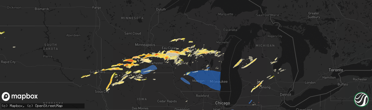
Hail Map in Wisconsin on April 13, 2026
The weather event in Wisconsin on April 13, 2026 includes Hail, Wind, and Tornado maps. 14 states and 902 cities were impacted and suffered possible damage. The total estimated number of properties impacted is 80,334.
Hail
Wind
Tornado
80,334
Estimated number of impacted properties by a 1.00" hail or larger16,010
Estimated number of impacted properties by a 1.75" hail or larger691
Estimated number of impacted properties by a 2.50" hail or largerStorm reports in Wisconsin
Wisconsin
| Date | Description |
|---|---|
| 04/13/20266:57 PM CDT | A local report indicates 1.00 inch wind near 6 SW Augusta |
| 04/13/20266:50 PM CDT | Time estimated via radar. |
| 04/13/20266:42 PM CDT | Report from mping: quarter |
| 04/13/20266:41 PM CDT | A local report indicates 1.75 inch wind near Osseo |
| 04/13/20266:40 PM CDT | A local report indicates 1.75 inch wind near Chili |
| 04/13/20266:37 PM CDT | A local report indicates 1.25 inch wind near 2 ESE Peru |
| 04/13/20266:35 PM CDT | A local report indicates 1.75 inch wind near 4 ENE Strum |
| 04/13/20266:35 PM CDT | A local report indicates 1.50 inch wind near 4 N Alma |
| 04/13/20266:34 PM CDT | A local report indicates 1.00 inch wind near Strum |
| 04/13/20266:28 PM CDT | A local report indicates 1.00 inch wind near Nelson |
| 04/13/20266:25 PM CDT | A local report indicates 1.25 inch wind near 1 NW Nelson |
| 04/13/20266:17 PM CDT | Tornado lifting and dropping onto the ground. |
| 04/13/20266:14 PM CDT | A local report indicates 1.50 inch wind near 1 NW Nelson |
| 04/13/20266:08 PM CDT | A local report indicates 1.25 inch wind near 5 NE Marshfield |
| 04/13/20266:06 PM CDT | A local report indicates 2.00 inch wind near 2 N Marshfield |
| 04/13/20266:00 PM CDT | Report from mping: half dollar |
| 04/13/20265:55 PM CDT | A local report indicates 1.00 inch wind near 1 E Wausau |
| 04/13/20265:55 PM CDT | A local report indicates 1.00 inch wind near Marshfield |
| 04/13/20265:43 PM CDT | A local report indicates 1.25 inch wind near 2 N Chili |
| 04/13/20265:40 PM CDT | A local report indicates 1.00 inch wind near 2 N Chili |
| 04/13/20265:26 PM CDT | A local report indicates 1.00 inch wind near 3 ESE Neillsville |
| 04/13/20265:25 PM CDT | A local report indicates 1.25 inch wind near 1 NNE Cornell |
| 04/13/20265:25 PM CDT | Report from mping: quarter |
| 04/13/20265:23 PM CDT | Report from mping: half dollar |
| 04/13/20265:17 PM CDT | A local report indicates 1.00 inch wind near Vesper |
| 04/13/20265:16 PM CDT | A local report indicates 1.00 inch wind near Neillsville |
| 04/13/20265:05 PM CDT | A local report indicates 1.00 inch wind near 1 SW Durand |
| 04/13/20264:34 PM CDT | A local report indicates 1.00 inch wind near Ellis |
| 04/13/20263:36 PM CDT | Report from mping: quarter |
| 04/13/20262:17 AM CDT | Trained spotter reports large oak tree snapped at base and fallen in road. |
| 04/13/20261:56 AM CDT | A total of six trees down across various portions of the county. One tree was down on a power line. Time estimated from radar. |
| 04/13/20261:55 AM CDT | Timmerman airport awos. |
| 04/13/20261:44 AM CDT | Social media reports of trees down and tree limbs down across southwestern milwaukee. Time estimated by radar. |
| 04/13/20261:40 AM CDT | Multiple social media reports of broken tree limbs and downed trees in northern and western milwaukee. Time estimated by radar. |
| 04/13/20261:40 AM CDT | Broadcast media reports large tree down on cars on the corner of 20th and west greenfield ave in milwaukee. Time estimated via radar. |
| 04/13/20261:39 AM CDT | Siding damage. |
| 04/13/20261:37 AM CDT | Concentrated area of trees and power lines down. Time estimated from radar. |
| 04/13/20261:30 AM CDT | Reports of trees down throughout the county. Time estimated from radar. |
| 04/13/20261:28 AM CDT | Several large trees down. |
| 04/13/20261:27 AM CDT | Several large trees uprooted or blown down. Some large trees fell on roofs of homes. Located in subdivision on corby drive and karin drive. Time estimated from radar. |
| 04/13/20261:24 AM CDT | Social media report with pictures of uprooted pine trees in lisbon. Time estimated by radar. |
| 04/13/20261:17 AM CDT | A local report indicates 60 MPH wind near 4 SSE Sullivan |
| 04/13/20261:17 AM CDT | Widespread tree damage reported along the west side of lake okauchee. Report relayed by nws employee. Time estimated from radar. |
| 04/13/20261:15 AM CDT | Large trees down on highway z and in surrounding areas. Time estimated from radar. |
| 04/13/20261:14 AM CDT | Trees down. |
| 04/13/20261:14 AM CDT | Large pine tree snapped about halfway up the trunk just north of intersection of highway f and ci. Time estimated from radar. |
| 04/13/20261:14 AM CDT | A local report indicates 60 MPH wind near 1 W Oconomowoc |
| 04/13/20261:10 AM CDT | Trained spotter estimates 60 mph winds with dozens of trees downed... Uprooted... Or snapped. |
| 04/13/20261:10 AM CDT | Public report of widespread tree damage and small building damage between ashippun and erin. Time estimated by radar. |
| 04/13/20261:07 AM CDT | A couple trees down. |
| 04/13/20261:04 AM CDT | Grouping of trees down. |
| 04/13/20261:01 AM CDT | Public report of multiple trees down across the south side of fort atkinson... As well as some roof damage. Time estimated by radar. |
| 04/13/20261:00 AM CDT | Many trees down and uprooted... With one tree down on a house in the lee drive and aspen drive area. Time estimated from radar. |
| 04/13/20261:00 AM CDT | A roof removed from a home on jackson street in jefferson. Some tree damage in the city. |
| 04/13/20261:00 AM CDT | Scattered trees down throughout jefferson county between 12:46 am to 1:20 am. |
| 04/13/202612:50 AM CDT | Countywide widespread tree and power line damage across dodge county from straight line winds. Time approximated via radar data. |
| 04/13/202612:44 AM CDT | Garage and part of the roof that was attached to the home was blown away. Time estimated from radar. |
| 04/13/202612:44 AM CDT | North side of a wall of a barn was blown in... And the barn door on the south end of that barn was blown across the road and into a field. Time estimated from radar. |
| 04/13/202612:38 AM CDT | Two large trees blown down. A pine tree snapped at 80 feet high. Additional tree branches down in area. |
| 04/13/202612:36 AM CDT | Public report of hollow oak tree 4 ft in diameter snapped at base. Time estimated by radar. |
| 04/13/202612:35 AM CDT | Broadcast media reports roof damage at the st. Joseph church in east bristol. Time estimated via radar data. |
| 04/13/202612:30 AM CDT | Trained spotter reports numerous trees snapped off 10-15 feet off ground level. Tree fall caused damage to fiber glass roof of a shed. |
| 04/13/202612:30 AM CDT | Trained spotter reports multiple trees down... With some tree fall on vehicles with damage. |
| 04/13/202612:26 AM CDT | Power poles and power lines down. A tree down on a house. |
| 04/13/202612:25 AM CDT | Garage door and a 1000 pound cattle ramp were thrown into a ditch at the alliant energy center. Time estimated from radar. |
| 04/13/202612:25 AM CDT | A credit union has an i beam through the side of the building. Time estimated from radar. |
| 04/13/202612:23 AM CDT | Multiple trees down near yahara elementary school. 1 fully uprooted and another snapped. |
| 04/13/202612:22 AM CDT | Report from mping: half dollar |
| 04/13/202612:20 AM CDT | Portions of a roof and beams lifted off a house. Images sent via facebook. Time estimated by radar. |
| 04/13/202612:19 AM CDT | One tree down near dalton. Time estimated from radar. |
| 04/13/202612:15 AM CDT | Social media photo post of sheet metal roofing torn off of a dairy barn... As well as some sheet metal siding removed. |
| 04/13/202612:15 AM CDT | Several trees down throughout the county. Time estimated from radar. |
| 04/13/202612:12 AM CDT | Roof collapse at a nursing home. Power lines and trees down. |
| 04/13/202612:10 AM CDT | Reports of trees twisted and down along with roof damage along delany street and dodgeville street in village of highland. Time estimated from radar. |
| 04/13/202612:06 AM CDT | Trees and power lines down. Trees on homes. |
| 04/13/202612:05 AM CDT | Corrects previous tstm wnd dmg report from 1 nnw prairie du sac. Trees and power lines down. Possible major roof damage at a factory. Tree down on a home. |
| 04/13/202612:05 AM CDT | Trained spotter reports snapped pine tree with fall occurring on a house. |
| 04/13/202612:05 AM CDT | Trees and power lines down. Minor roof damage to a couple buildings. |
| 04/12/202611:59 PM CDT | Barn collapsed and occupied with 30-40 cattle. |
| 04/12/202611:49 PM CDT | Trees and power lines down. |
| 04/12/202611:47 PM CDT | Sauk county sheriffs office reports part of the fire department roof torn off. Time estimated by radar. |
| 04/12/202611:46 PM CDT | Pole shed down in rock springs. |
| 04/12/202611:44 PM CDT | Public report of an outbuilding destroyed... As well as multiple trees down within the property. Time estimated by radar. |
| 04/12/202611:42 PM CDT | Trees and power lines down. |
| 04/12/202611:38 PM CDT | Shed removed from foundation. |
| 04/12/202610:05 PM CDT | A local report indicates 1.00 inch wind near 6 S Four Corners |
| 04/12/20269:23 PM CDT | A local report indicates 1.00 inch wind near Fort Mc Coy |
| 04/12/20269:23 PM CDT | Hailing at the time of the report. |
| 04/12/20268:39 PM CDT | A local report indicates 1.00 inch wind near 2 S Millston |
| 04/12/20268:15 PM CDT | A local report indicates 1.00 inch wind near Warrens |
| 04/12/20267:37 PM CDT | Quarter sized to half dollar sized hail. Corner of allard ave. And camm place. |
| 04/12/20267:35 PM CDT | A local report indicates 1.00 inch wind near 3 WNW Sidney |
| 04/12/20267:35 PM CDT | A local report indicates 1.00 inch wind near 1 WNW Green Bay |
| 04/12/20267:34 PM CDT | Report from mping: quarter |
| 04/12/20267:32 PM CDT | Report from mping: quarter |
| 04/12/20267:22 PM CDT | A local report indicates 1.75 inch wind near 7 WNW Humbird |
| 04/12/20267:15 PM CDT | A local report indicates 1.00 inch wind near 1 NW Clintonville |
| 04/12/20267:10 PM CDT | A local report indicates 2.00 inch wind near Humbird |
| 04/12/20267:03 PM CDT | Report made at 713pm after hail core had passed this location. Time of hailfall estimated from radar. |
All States Impacted by Hail Map on April 13, 2026
Cities Impacted by Hail Map on April 13, 2026
- Hamilton, IL
- Nauvoo, IL
- Bradford, IL
- Wyoming, IL
- Henry, IL
- Sparland, IL
- Clinton, IA
- Bryant, IA
- Wenona, IL
- Putnam, IL
- Streator, IL
- Magnolia, IL
- Lacon, IL
- Hennepin, IL
- Sabula, IA
- McNabb, IL
- Granville, IL
- Sterling, IL
- Peru, IL
- Standard, IL
- Oglesby, IL
- Ottawa, IL
- Cabery, IL
- Dwight, IL
- Buckingham, IL
- Odell, IL
- Emington, IL
- Campus, IL
- Utica, IL
- Marseilles, IL
- Reddick, IL
- Herscher, IL
- Gardner, IL
- Union Hill, IL
- Bonfield, IL
- Essex, IL
- Wilmington, IL
- Kankakee, IL
- Chebanse, IL
- Martinton, IL
- Saint Anne, IL
- Papineau, IL
- Beaverville, IL
- Weston, WY
- Grant Park, IL
- Momence, IL
- Broadus, MT
- Hammond, MT
- Bourbonnais, IL
- Moorcroft, WY
- Hulett, WY
- Lowell, IN
- Alzada, MT
- Watseka, IL
- Donovan, IL
- Dryden, TX
- Hillpoint, WI
- Loganville, WI
- La Valle, WI
- Lime Ridge, WI
- Reedsburg, WI
- Morocco, IN
- Richland Center, WI
- Pembroke Township, IL
- Cazenovia, WI
- Faribault, MN
- Capitol, MT
- Northfield, MN
- Nerstrand, MN
- Fort Stockton, TX
- Ekalaka, MT
- Dennison, MN
- Rensselaer, IN
- Fair Oaks, IN
- Mount Ayr, IN
- Kenyon, MN
- Cannon Falls, MN
- Tripp, SD
- Olivet, SD
- Baraboo, WI
- Camp Crook, SD
- Goodhue, MN
- Portage, WI
- Burns, KS
- Menno, SD
- Freeman, SD
- Cedar Point, KS
- Anson, TX
- Red Wing, MN
- Welch, MN
- Stevens Point, WI
- Stockholm, WI
- Pepin, WI
- Buffalo, SD
- Midkiff, TX
- Sweetwater, TX
- Roby, TX
- Sylvester, TX
- McCaulley, TX
- Custer, WI
- Rosholt, WI
- Cottonwood Falls, KS
- Hatley, WI
- Howe, IN
- Plum City, WI
- Spencer, WI
- Loyal, WI
- Granton, WI
- Wittenberg, WI
- Eland, WI
- Sturgis, MI
- Neillsville, WI
- Marshfield, WI
- Big Lake, TX
- Maiden Rock, WI
- Nelson, WI
- Strong City, KS
- Durand, WI
- Marion, SD
- Constantine, MI
- Three Rivers, MI
- Emporia, KS
- Centreville, MI
- Mendon, MI
- Bowler, WI
- Burr Oak, MI
- Merrillan, WI
- Wisconsin Rapids, WI
- Pittsville, WI
- Stratford, WI
- Tigerton, WI
- Vesper, WI
- Hamlin, TX
- Haskell, TX
- Wheeler, WI
- Weinert, TX
- Chili, WI
- Garden City, TX
- Eleva, WI
- Strum, WI
- Kingsley, IA
- Moville, IA
- Cornell, WI
- Bronson, MI
- Birnamwood, WI
- Parker, SD
- Holcombe, WI
- Odin, MN
- Lake City, MN
- Humbird, WI
- Bloomer, WI
- Lonsdale, MN
- New Prague, MN
- Zumbrota, MN
- Montgomery, MN
- Kilkenny, MN
- Throckmorton, TX
- Americus, KS
- Arpin, WI
- Sterling City, TX
- Columbia City, IN
- Roanoke, IN
- Fort Wayne, IN
- Arcola, IN
- Gilman, WI
- Saint James, MN
- Butterfield, MN
- Ormsby, MN
- Union Center, SD
- Nicollet, MN
- Le Mars, IA
- Remsen, IA
- Hinton, IA
- Marathon, WI
- Mosinee, WI
- Mondovi, WI
- Rudolph, WI
- Fulda, MN
- Mankato, MN
- Boyd, WI
- Osseo, WI
- Frontenac, MN
- Marcus, IA
- Stamford, TX
- Reading, KS
- Saint Peter, MN
- Sheldon, WI
- Wausau, WI
- Lewisville, MN
- Ruthven, IA
- Dickens, IA
- Pierson, IA
- Le Center, MN
- Seymour, TX
- Heron Lake, MN
- Comfrey, MN
- Darfur, MN
- Estherville, IA
- Granville, IA
- Paullina, IA
- Avoca, TX
- Medford, WI
- Sioux Falls, SD
- Tea, SD
- Lennox, SD
- Kasota, MN
- Ossian, IN
- Yoder, IN
- Decatur, IN
- Hoagland, IN
- Monroeville, IN
- New Haven, IN
- Woodburn, IN
- Grabill, IN
- Wabasha, MN
- Reads Landing, MN
- Amboy, MN
- Truman, MN
- Vernon Center, MN
- Hanska, MN
- Sleepy Eye, MN
- Auburndale, WI
- Webster, MN
- Windom, MN
- Edgar, WI
- Plainwell, MI
- Armstrong, IA
- Schofield, WI
- Dundas, MN
- Plover, WI
- Osage City, KS
- Westboro, WI
- Archer, IA
- Graettinger, IA
- Cleveland, MN
- Amherst Junction, WI
- Amherst, WI
- Scandinavia, WI
- Nelsonville, WI
- Iola, WI
- Convoy, OH
- Antwerp, OH
- Payne, OH
- Paulding, OH
- Scott, OH
- Haviland, OH
- Cecil, OH
- Alma, WI
- Fall Creek, WI
- Kellogg, MN
- Westbrook, TX
- Melvin, IA
- Ocheyedan, IA
- Arkansaw, WI
- Delton, MI
- Council Grove, KS
- Dolliver, IA
- Emmetsburg, IA
- Valley Springs, SD
- Fountain City, WI
- Cochrane, WI
- Elmdale, KS
- Loraine, TX
- Colorado City, TX
- Lyndon, KS
- Sanborn, IA
- Primghar, IA
- Vassar, KS
- Hastings, MI
- Grover Hill, OH
- Cloverdale, OH
- Oakwood, OH
- Latty, OH
- Melrose, OH
- Defiance, OH
- Good Thunder, MN
- Madelia, MN
- Roscoe, TX
- Whitehall, WI
- Altura, MN
- Morristown, MN
- Waseca, MN
- Brandon, SD
- Chancellor, SD
- Admire, KS
- Cleghorn, IA
- Bingham Lake, MN
- Mountain Lake, MN
- Augusta, WI
- Janesville, MN
- Allen, KS
- Beaver Creek, MN
- Milladore, WI
- Madison Lake, MN
- Lake Park, IA
- Harris, IA
- Arcadia, WI
- Hartford, SD
- Fairchild, WI
- Cherokee, IA
- Meriden, IA
- Spencer, IA
- Royal, IA
- Fairmont, MN
- Wallingford, IA
- Ceylon, MN
- Lebo, KS
- Melvern, KS
- Lake Crystal, MN
- Quenemo, KS
- Waterville, MN
- Elysian, MN
- Ashton, IA
- Sibley, IA
- Medford, MN
- Owatonna, MN
- Alma Center, WI
- Marion, WI
- Manawa, WI
- Ogdensburg, WI
- Hartley, IA
- Junction City, WI
- Larrabee, IA
- Independence, WI
- Peterson, IA
- Athens, WI
- Mapleton, MN
- Swea City, IA
- Granada, MN
- Humboldt, KS
- Ringsted, IA
- Springfield, MN
- Terril, IA
- Milford, IA
- Luverne, MN
- Eskridge, KS
- Piqua, KS
- Bear Creek, WI
- Clintonville, WI
- Continental, OH
- Freeport, MI
- Woodland, MI
- Lake Odessa, MI
- Vermontville, MI
- Hermleigh, TX
- Stanley, WI
- Willard, WI
- Garden City, MN
- New London, WI
- Spalding, NE
- New Ulm, MN
- Spirit Lake, IA
- Arnolds Park, IA
- Winnebago, MN
- Hixton, WI
- Scranton, KS
- Burlingame, KS
- Magnolia, MN
- Iola, KS
- Elmore, MN
- Blue Earth, MN
- Pomona, KS
- Sutherland, IA
- Embarrass, WI
- Aurelia, IA
- Linn Grove, IA
- Overbrook, KS
- Everly, IA
- Sunfield, MI
- Portland, MI
- Ottawa, KS
- Minnesota Lake, MN
- Shiocton, WI
- Blair, WI
- Ettrick, WI
- Ledyard, IA
- Rushmore, MN
- Rotan, TX
- Adrian, MN
- Merrill, WI
- La Harpe, KS
- Moran, KS
- Wanamingo, MN
- Primrose, NE
- Oregon, OH
- Carbondale, KS
- McComb, OH
- Lismore, MN
- Wilmont, MN
- Westphalia, MI
- Pewamo, MI
- Williamsburg, KS
- Waldorf, MN
- Green Bay, WI
- Kincaid, KS
- Blue Mound, KS
- Claremont, MN
- West Concord, MN
- Reading, MN
- Burt, IA
- Lone Rock, IA
- Taylor, WI
- Webb, IA
- Sioux Rapids, IA
- Greenville, IA
- De Pere, WI
- Buffalo Center, IA
- Mazeppa, MN
- Oneida, WI
- Bonduel, WI
- Black Creek, WI
- Baldwin City, KS
- Curtice, OH
- Greenwood, WI
- Bancroft, IA
- Fenton, IA
- Bronson, KS
- Galesville, WI
- Seymour, WI
- Caroline, WI
- Leopolis, WI
- Pemberton, MN
- Worthington, MN
- Brewster, MN
- Melrose, WI
- Black River Falls, WI
- Lawrence, KS
- Saint Johns, MI
- Fowler, MI
- Pulaski, WI
- Hewitt, WI
- New Franken, WI
- Millbury, OH
- Frost, MN
- Bricelyn, MN
- Rake, IA
- Thompson, IA
- Ayrshire, IA
- Gillett Grove, IA
- Titonka, IA
- Aspermont, TX
- Eagle, MI
- Grand Ledge, MI
- Wellsville, KS
- Trimont, MN
- Lyons, MI
- Luxemburg, WI
- Round Lake, MN
- Hospers, IA
- Dodge Center, MN
- Shawano, WI
- Toledo, OH
- Rantoul, KS
- Paola, KS
- Edgerton, KS
- Wells, MN
- Kiester, MN
- Eagle Lake, MN
- Millville, MN
- Mound City, KS
- Okabena, MN
- Curlew, IA
- Spring Hill, KS
- Laurens, IA
- Delavan, MN
- Zumbro Falls, MN
- Warsaw, MN
- Scarville, IA
- Lakefield, MN
- Emmons, MN
- Alden, MN
- Louisburg, KS
- Bucyrus, KS
- Sparta, WI
- Pine Island, MN
- Gardner, KS
- Pleasanton, KS
- Suamico, WI
- Twin Lakes, MN
- Hayward, MN
- Glenville, MN
- Northwood, IA
- Albert Lea, MN
- Lake Mills, IA
- Conger, MN
- Eudora, KS
- Hollandale, MN
- Austin, MN
- Old Glory, TX
- Cleveland, MO
- Stilwell, KS
- Lyle, MN
- Saint Ansgar, IA
- Foster, MO
- Tomah, WI
- Warrens, WI
- Bangor, WI
- Mindoro, WI
- Oakley, MI
- Chesaning, MI
- Mantorville, MN
- Amoret, MO
- Belton, MO
- Jackson, MN
- Lansing, MN
- Waltham, MN
- Rose Creek, MN
- Brownsdale, MN
- Peculiar, MO
- Freeman, MO
- Butler, MO
- Raymore, MO
- Pleasant Hill, MO
- Kansas City, MO
- Grandview, MO
- Lees Summit, MO
- Greenwood, MO
- Hayfield, MN
- Blooming Prairie, MN
- Kasson, MN
- Sargeant, MN
- Byron, MN
- Dexter, MN
- Elkton, MN
- Adams, MN
- Grand Meadow, MN
- Stewartville, MN
- Saint Charles, MI
- Montrose, MI
- Joice, IA
- Woden, IA
- Burt, MI
- Birch Run, MI
- Saginaw, MI
- Bridgeport, MI
- Alpha, MN
- Kingsville, MO
- Strasburg, MO
- Lone Jack, MO
- Wesley, IA
- Nekoosa, WI
- Port Edwards, WI
- Nichols, WI
- Minnesota City, MN
- Forest City, IA
- Britt, IA
- Warrensburg, MO
- Holden, MO
- Centerview, MO
- Bates City, MO
- Odessa, MO
- Oak Grove, MO
- Mayview, MO
- Higginsville, MO
- Wellington, MO
- Lexington, MO
- Grain Valley, MO
- Garner, IA
- Denmark, WI
- Greenleaf, WI
- Camp Douglas, WI
- Winona, MN
- Bancroft, WI
- Plainfield, WI
- Kewaunee, WI
- Necedah, WI
- Trempealeau, WI
- Norwalk, WI
- Friendship, WI
- Almond, WI
- Caro, MI
- Vassar, MI
- Reese, MI
- Fairgrove, MI
- Waupaca, WI
- Leland, IA
- Crystal Lake, IA
- Ventura, IA
- Fertile, IA
- Clear Lake, IA
- Weyauwega, WI
- Holmen, WI
- Cass City, MI
- Standish, MI
- Bentley, MI
- Urich, MO
- Blairstown, MO
- Clinton, MO
- Chilhowee, MO
- Arkdale, WI
- Waverly, MO
- Alma, MO
- Concordia, MO
- Corder, MO
- Malta Bend, MO
- Blackburn, MO
- Carrollton, MO
- Sweet Springs, MO
- Miami, MO
- Knob Noster, MO
- Marshall, MO
- Calhoun, MO
- Windsor, MO
- Harrisonville, MO
- Omer, MI
- Au Gres, MI
- Hancock, WI
- Mason City, IA
- Lanesboro, MN
- Sterling, MI
- Lincoln, MO
- Warsaw, MO
- Walkerville, MI
- Hart, MI
- Twining, MI
- Turner, MI
- Ludington, MI
- Whittemore, MI
- East Lynne, MO
- Wautoma, WI
- Free Soil, MI
- Manistee, MI
- Scottville, MI
- Garden City, MO
- National City, MI
- Tawas City, MI
- New Lisbon, WI
- Branch, MI
- Bitely, MI
- Cole Camp, MO
- Baldwin, MI
- Idlewild, MI
- Charles City, IA
- Ripon, WI
- Pickett, WI
- Edwards, MO
- Stover, MO
- Gravois Mills, MO
- Versailles, MO
- Eldorado, WI
- Oshkosh, WI
- McIntire, IA
- Riceville, IA
- Manitowoc, WI
- Reedsville, WI
- Chase, MI
- Reed City, MI
- Colwell, IA
- Ionia, IA
- Alta Vista, IA
- Luther, MI
- Leroy, MI
- Tustin, MI
- Glenbeulah, WI
- Plymouth, WI
- Wellston, MI
- Le Roy, MN
- Chester, IA
- Marion, MI
- McBain, MI
- Cadillac, MI
- Sheboygan Falls, WI
- Boon, MI
- Harrietta, MI
- Ionia, MI
- Cambria, WI
- Markesan, WI
- Randolph, WI
- Muir, MI
- Mesick, MI
- Orleans, MI
- Fenwick, MI
- Waupun, WI
- Brandon, WI
- Stoughton, WI
- Rosendale, WI
- Taopi, MN
- Fox Lake, WI
- Oakfield, WI
- Irons, MI
- Harrison, MI
- Gladwin, MI
- Brant, MI
- Fountain, MI
- Ashley, MI
- Coon Valley, WI
- Higbee, MO
- Huntsville, MO
- Lannon, WI
- Menomonee Falls, WI
- Sussex, WI
- Moberly, MO
- Madison, MO
- Jacksonville, MO
- Cairo, MO
- Bay City, MI
- Munger, MI
- Essexville, MI
- Waukesha, WI
- Pewaukee, WI
- Brookfield, WI
- Elm Grove, WI
- Milwaukee, WI
- Akron, MI
- Unionville, MI
- Atlanta, MO
- Sebewaing, MI
- Clarence, MO
- Excello, MO
- Leonard, MO
- Owendale, MI
- Gagetown, MI
- Shelbina, MO
- Bethel, MO
- Novelty, MO
- Shelbyville, MO
- Edina, MO
- Rutledge, MO
- Hurdland, MO
- Newark, MO
- Knox City, MO
- Hunnewell, MO
- Paris, MO
- Lewistown, MO
- La Belle, MO
- Palmyra, MO
- Monroe City, MO
- Ewing, MO
- Wyaconda, MO
- Kahoka, MO
- Williamstown, MO
- Saint Patrick, MO
- Monticello, MO
- Quincy, IL
- Barnett, MO
- Camp Point, IL
- Fowler, IL
- Orion, IL
- Osco, IL
- Rothschild, WI
- Geneseo, IL
- Atkinson, IL
- Ostrander, MN
- Spring Valley, MN
- Racine, MN
- Oconomowoc, WI
- Hartland, WI
- Nashotah, WI
- Okauchee, WI
- Sullivan, WI
- Jefferson, WI
- Delafield, WI
- Watertown, WI
- Helenville, WI
- Johnson Creek, WI
- Fort Atkinson, WI
- Dousman, WI
- Palmyra, WI
- Wales, WI
- Eagle, WI
- North Prairie, WI
- Mukwonago, WI
- New Berlin, WI
- Butler, WI
- Mendota, IL
- Troy Grove, IL
- Kewanee, IL
- Toulon, IL
- Neponset, IL
- Morris, IL
- Tonica, IL
- Lostant, IL
- Waunakee, WI
- Middleton, WI
- Cross Plains, WI
- Green Ridge, MO
- Sedalia, MO
- Ionia, MO
- Mora, MO
- Smithton, MO
- Fortuna, MO
- Florence, MO
- Lake Mills, WI
- Cambridge, WI
- Waterloo, WI
- Cottage Grove, WI
- Deerfield, WI
- Marshall, WI
- Sun Prairie, WI
- Madison, WI
- Deforest, WI
- Windsor, WI
- Arlington, WI
- Lodi, WI
- Dane, WI
- Morrisonville, WI
- Columbus, WI
- Rio, WI
- Poynette, WI
- Merrimac, WI
- North Freedom, WI
- Pardeeville, WI
- Ubly, MI
- Bad Axe, MI
- Rock Springs, WI
- Wisconsin Dells, WI
- Wyocena, WI
- Doylestown, WI
- Fall River, WI
- Juneau, WI
- Burnett, WI
- Beaver Dam, WI
- Lowell, WI
- Reeseville, WI
- Iron Ridge, WI
- Horicon, WI
- Allenton, WI
- Rubicon, WI
- Mayville, WI
- Neosho, WI
- Clyman, WI
- Hustisford, WI
- Hartford, WI
- Lebanon, WI
- Jackson, WI
- Slinger, WI
- Richfield, WI
- West Bend, WI
- Ixonia, WI
- Ashippun, WI
- Germantown, WI
- Mequon, WI
- Cedarburg, WI
- Colgate, WI
- Hubertus, WI
- Friesland, WI
- Theresa, WI
- Lomira, WI
- Brownsville, WI
- Campbellsport, WI
- Kewaskum, WI
- Fredonia, WI
- Random Lake, WI
- Cedar Grove, WI
- Port Washington, WI
- Grafton, WI
- Belgium, WI
- Saukville, WI
- Prairie Du Sac, WI
- Sauk City, WI
- Mazomanie, WI
- Oregon, WI
- Mcfarland, WI
- Edgerton, WI
- Whitewater, WI
- East Troy, WI
- Elkhorn, WI
- Burlington, WI
- Waterford, WI
- Big Bend, WI
- Salem, WI
- Kansasville, WI
- Rochester, WI
- Kenosha, WI
- Muskego, WI
- Union Grove, WI
- Bristol, WI
- Sturtevant, WI
- Franksville, WI
- Pleasant Prairie, WI
- Caledonia, WI
- Franklin, WI
- Racine, WI
- Oak Creek, WI
- Greendale, WI
- Hales Corners, WI
- South Milwaukee, WI
- Cudahy, WI
- Saint Francis, WI
- Plain, WI
- Olathe, KS
- Overland Park, KS
- Dover, MO
- Dodgeville, WI
- Blue River, WI
- Hollandale, WI
- Mineral Point, WI
- Avoca, WI
- Muscoda, WI
- Cobb, WI
- Highland, WI
- Boscobel, WI
- Brook, IN
- Union Mills, IN
- Wanatah, IN
- Westville, IN
- Hanna, IN
- Valparaiso, IN
- Fond Du Lac, WI
- Kenneth, MN
- Coldwater, MI
- New Richland, MN


