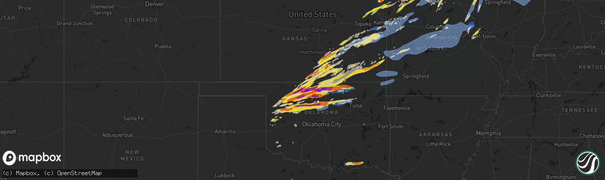
Hail Map on April 17, 2026
The weather event on April 17, 2026 includes Hail, Tornado, and Wind maps. 10 states and 2,021 cities were impacted and suffered possible damage. The total estimated number of properties impacted is 565,629.
Hail
Tornado
Wind
565,629
Estimated number of impacted properties by a 1.00" hail or larger138,823
Estimated number of impacted properties by a 1.75" hail or larger48,405
Estimated number of impacted properties by a 2.50" hail or largerStates Impacted by Hail Map on April 17, 2026
Storm reports
Minnesota
| Date | Description |
|---|---|
| 04/17/20263:51 PM CDT | Mostly pea size but a few one inch to one and a quarter inch found about 45 minutes after the storm passed. |
| 04/17/20263:20 PM CDT | Majority of hail was three quarters to one inch in size but some pieces as large as 1.5 inches. Photo sent to nws duluth. Time estimated from radar. |
| 04/17/20263:19 PM CDT | A local report indicates 1.00 inch wind near Rollingstone |
| 04/17/20263:19 PM CDT | Emergency manager reported quarter size hail in rollingstone. |
| 04/17/20263:12 PM CDT | Report via social media. |
| 04/17/20263:10 PM CDT | A local report indicates 1.25 inch wind near 3 SE Douglas |
| 04/17/20263:05 PM CDT | A local report indicates 1.00 inch wind near Altura |
| 04/17/20263:05 PM CDT | A local report indicates 1.50 inch wind near Saint Charles |
| 04/17/20263:01 PM CDT | A local report indicates 1.00 inch wind near 4 NNW Hermantown |
| 04/17/20263:00 PM CDT | A local report indicates 1.50 inch wind near Saint Charles |
| 04/17/20263:00 PM CDT | Picture via social media of three 5 inch diameter softwood trees broken a few feet up the trunks. Time estimated from radar. |
| 04/17/20262:57 PM CDT | Tornado caused roof damage and removed a barn off of its foundation at 50500 county rd... Plainview... Mn. Residents saw the tornado and took shelter in a basement. No |
| 04/17/20262:53 PM CDT | Tornado touched down north of elgin where it flipped a semi. It caused damage on 2 farmsteads. Ended 1 3/4 miles north of 247 near county rd 2. |
| 04/17/20262:53 PM CDT | Tornado touched down north of elgin where it flipped a semi. It caused damage on 2 farmsteads. Ended 1 3/4 miles north of 247 near county rd 2. |
| 04/17/20262:46 PM CDT | The ef2 tornado affected mainly rural areas northeast of rochester mn beginning about 5 miles east-northeast of viola in olmsted county around 2:46 pm. The tornado trac |
| 04/17/20262:41 PM CDT | Report from mping: quarter |
| 04/17/20262:40 PM CDT | Report from mping: quarter |
| 04/17/20262:32 PM CDT | Rochester tower reported tornado on the ground near highway 63. |
| 04/17/20262:32 PM CDT | Rochester tower reported tornado on the ground near highway 63. |
| 04/17/20262:30 PM CDT | The tornado began in a northeast suburb of rochester at around 2:30 pm with just shingle damage to homes and traveled northeast into more rural areas. The first portion |
| 04/17/20262:17 PM CDT | This ef-2 tornado |
| 04/17/20262:15 PM CDT | A local report indicates 1.00 inch wind near 2 WNW Oronoco |
| 04/17/20262:13 PM CDT | A local report indicates 1.75 inch wind near 4 N Rochester |
| 04/17/20262:13 PM CDT | Report from mping: quarter |
| 04/17/20262:12 PM CDT | Report from mping: ping pong ball |
| 04/17/20262:10 PM CDT | Report from mping: quarter |
| 04/17/20262:08 PM CDT | Report from mping: quarter |
| 04/17/20262:08 PM CDT | Report from mping: half dollar |
| 04/17/20262:05 PM CDT | Report from mping: ping pong ball |
| 04/17/20262:04 PM CDT | A local report indicates 1.00 inch wind near Dexter |
| 04/17/20261:53 PM CDT | This ef0 tornado affected mainly rural areas southeast of oslo mn with estimated max winds around 80 mph. Mainly farm outbuildings and trees sustained light damage duri |
| 04/17/20261:50 PM CDT | Sheriff deputy reported that a tornado formed and dissipated and then a second tornado touched down. |
| 04/17/20261:50 PM CDT | Sheriff deputy reported that a tornado formed and dissipated and then a second tornado touched down. |
| 04/17/20261:46 PM CDT | A local report indicates 1.00 inch wind near Hayfield |
| 04/17/20261:45 PM CDT | A local report indicates 1.00 inch wind near 1 S Kasson |
| 04/17/20261:41 PM CDT | A local report indicates 1.00 inch wind near Hayfield |
| 04/17/20261:37 PM CDT | A local report indicates 1.00 inch wind near Hayfield |
| 04/17/20261:36 PM CDT | A local report indicates 1.75 inch wind near 1 W Hayfield |
| 04/17/202610:12 AM CDT | Hail measurement photo provided via nwschat. Time estimated via radar. |
| 04/17/202610:08 AM CDT | A local report indicates 1.00 inch wind near 1 S Cannon Falls |
| 04/17/20269:30 AM CDT | A local report indicates 1.00 inch wind near 4 NE Faribault |
| 04/17/20268:00 AM CDT | Report received via nwschat. Time estimated via radar. |
| 04/17/20267:12 AM CDT | Photo measurement provided via nwschat. Time estimated via radar. |
Oklahoma
| Date | Description |
|---|---|
| 04/17/20266:55 PM CDT | A local report indicates a tornado near 3 WSW Ponca City |
| 04/17/20266:52 PM CDT | Report from mping: quarter |
| 04/17/20266:48 PM CDT | A local report indicates 1.00 inch wind near Blackwell |
| 04/17/20266:46 PM CDT | A local report indicates 1.00 inch wind near 2 WNW Tonkawa |
| 04/17/20266:37 PM CDT | A local report indicates 3.00 inch wind near Lamont |
| 04/17/20266:30 PM CDT | A local report indicates 2.75 inch wind near Lamont |
| 04/17/20266:29 PM CDT | A local report indicates 1.25 inch wind near Lamont |
| 04/17/20266:27 PM CDT | A local report indicates 1.75 inch wind near Kremlin |
| 04/17/20266:25 PM CDT | Social media image showing a ruler measurement. Time estimated by radar. |
| 04/17/20266:24 PM CDT | A local report indicates 2.00 inch wind near 3 SE Jefferson |
| 04/17/20266:23 PM CDT | A local report indicates 1.50 inch wind near 2 N North Enid |
| 04/17/20266:22 PM CDT | A local report indicates 2.50 inch wind near 1 N North Enid |
| 04/17/20266:12 PM CDT | A local report indicates 1.75 inch wind near 3 E Pond Creek |
| 04/17/20266:10 PM CDT | A local report indicates 1.75 inch wind near Pond Creek |
| 04/17/20266:09 PM CDT | A local report indicates 1.00 inch wind near Pond Creek |
| 04/17/20266:09 PM CDT | Corrects previous hail report from pond creek. Social media image showing a ruler measurement. |
| 04/17/20265:51 PM CDT | Social media image showing a ruler measurement. |
| 04/17/20265:42 PM CDT | Report from mping: quarter |
| 04/17/20265:30 PM CDT | A local report indicates 1.25 inch wind near 1 SSE Helena |
| 04/17/20265:29 PM CDT | A local report indicates 1.75 inch wind near 4 E Aline |
| 04/17/20265:24 PM CDT | Facebook report with picture. Time based on radar. |
| 04/17/20265:09 PM CDT | Estimated size looks to be closer to 3.25 inches. |
| 04/17/20265:03 PM CDT | Report from mping: ping pong ball |
| 04/17/20265:02 PM CDT | Report from mping: quarter |
| 04/17/20264:58 PM CDT | A local report indicates 1.75 inch wind near Nash |
| 04/17/20264:53 PM CDT | A local report indicates 2.00 inch wind near 4 ENE Great Salt Plains |
| 04/17/20264:53 PM CDT | A local report indicates 2.50 inch wind near 1 E Lambert |
| 04/17/20264:52 PM CDT | A local report indicates 2.75 inch wind near Cherokee |
| 04/17/20264:51 PM CDT | Report from mping: ping pong ball |
| 04/17/20264:47 PM CDT | Nssl employee. |
| 04/17/20264:47 PM CDT | A local report indicates 1.00 inch wind near 9 N Chester |
| 04/17/20264:45 PM CDT | A local report indicates 2.00 inch wind near 2 WSW Dacoma |
| 04/17/20264:44 PM CDT | Report from mping: quarter |
| 04/17/20264:42 PM CDT | Corrects previous time from 4 w jet. Estimated size looks to be closer to 3.25 inches. |
| 04/17/20264:42 PM CDT | A local report indicates 2.00 inch wind near 7 E Lambert |
| 04/17/20264:40 PM CDT | A local report indicates 1.75 inch wind near 6 W Jet |
| 04/17/20264:35 PM CDT | A local report indicates 1.00 inch wind near 5 ESE Lambert |
| 04/17/20264:33 PM CDT | Report from mping: quarter |
| 04/17/20264:00 PM CDT | Time estimated by radar. |
| 04/17/20264:48 AM CDT | A local report indicates 1.75 inch wind near Boswell |
| 04/17/20264:35 AM CDT | Relayed from wfo tsa. |
| 04/17/20261:35 AM CDT | Madill |
| 04/17/202612:00 AM CDT | Klaw. |
| 04/16/202611:55 PM CDT | Walters |
| 04/16/202611:54 PM CDT | 200 pound well house lid blown off |
| 04/16/202611:50 PM CDT | A local report indicates 65 MPH wind near 4 NW Walters |
| 04/16/202611:46 PM CDT | Report from mping: quarter |
| 04/16/202611:28 PM CDT | Kfdr. |
| 04/16/202611:15 PM CDT | A local report indicates 59 MPH wind near 4 S Tipton |
| 04/16/202610:35 PM CDT | A local report indicates 59 MPH wind near 3 S Altus |
| 04/16/20269:55 PM CDT | A local report indicates 60 MPH wind near 3 SE Hobart |
| 04/16/20269:23 PM CDT | Ok mesonet. |
| 04/16/20269:20 PM CDT | Person who lives in hallett estimated that severe winds to around 60 mph blew through the town with the storm. Time estimated by radar. |
| 04/16/20269:20 PM CDT | Semi overturned on i-35. |
| 04/16/20269:15 PM CDT | Corrects previous tstm wnd gst report from 4 ne lovell. Ok mesonet. |
| 04/16/20269:13 PM CDT | Time estimated by radar. |
| 04/16/20268:26 PM CDT | Semi was blown over on the i-35 bridge near orlando. Time estimated from radar. Twitter report with video. |
| 04/16/20268:18 PM CDT | Tree damage on the west side of bartlesville. |
| 04/16/20268:18 PM CDT | A local report indicates 1.00 inch wind near Cheyenne |
| 04/16/20268:16 PM CDT | A local report indicates 2.50 inch wind near Marshall |
| 04/16/20268:15 PM CDT | A local report indicates 1.50 inch wind near Marshall |
| 04/16/20268:03 PM CDT | Spotter network report. Time estimated by radar. |
| 04/16/20267:27 PM CDT | A local report indicates 1.75 inch wind near Okeene |
| 04/16/20267:25 PM CDT | Media chaser showing tree damage in burbank. Time estimated from radar. |
| 04/16/20267:25 PM CDT | A local report indicates 1.25 inch wind near Okeene |
| 04/16/20267:23 PM CDT | A local report indicates 1.75 inch wind near 1 SW Okeene |
| 04/16/20267:20 PM CDT | Recorded by burbank mesonet station. |
| 04/16/20267:13 PM CDT | A tornado uprooted numerous trees... Damaged several homes... And snapped numerous large tree limbs in neighborhoods south of the dam. This damage was consistent with e |
| 04/16/20267:06 PM CDT | Spotter network report. Time estimated by radar. |
| 04/16/20267:06 PM CDT | Spotter network report. Time estimated by radar. |
| 04/16/20267:05 PM CDT | Several trees as well as power lines down and roads blocked. |
| 04/16/20267:04 PM CDT | Victory road completely blocked by fallen trees. Time estimated from radar. |
| 04/16/20267:04 PM CDT | Minor exterior and interior damage reported at osage casino. Possible tornado damage. Time estimated from radar. |
| 04/16/20267:02 PM CDT | The ponca city tornado continued into osage county. It moved through mccord where numerous trees were uprooted or snapped... Homes were damaged... And power poles were |
| 04/16/20267:01 PM CDT | A local report indicates 2.00 inch wind near 3 N Tonkawa |
Wisconsin
| Date | Description |
|---|---|
| 04/17/20266:46 PM CDT | Nws damage survey concludes an ef-1 tornado occurred with estimated peak winds of 100 mph. The tornado started near turtle creek by klug road... Lifting northeastward t |
| 04/17/20266:40 PM CDT | Nws storm survey concludes an ef-1 tornado occurred with estimated peak winds of 100 mph. The tornado started just north of school section road... Traveled along state |
| 04/17/20266:23 PM CDT | A local report indicates 1.75 inch wind near Milton |
| 04/17/20266:12 PM CDT | Time estimated from radar. |
| 04/17/20266:09 PM CDT | Corrects previous tornado report from 5 ene avalon. Snapped and uprooted trees... Damage to houses... And sheet metal wrapped around trees near emerald grove. Time esti |
| 04/17/20266:09 PM CDT | Snapped and uprooted trees... Damage to houses... And sheet metal wrapped around trees near emerald grove. Time estimated from radar. |
| 04/17/20266:05 PM CDT | Multiple reports of a tornado on the ground. |
| 04/17/20266:05 PM CDT | Nws damage survey concludes an ef-1 tornado occurred with estimated peak winds of 100 mph. The tornado started southwest of emerald grove and moved northeastward... Tak |
| 04/17/20265:42 PM CDT | Barn wall blown down in richwood... Wi. |
| 04/17/20265:42 PM CDT | A local report indicates 1.00 inch wind near Watertown |
| 04/17/20265:41 PM CDT | A local report indicates 1.00 inch wind near 3 NNW Footville |
| 04/17/20265:30 PM CDT | Relayed from broadcast media |
| 04/17/20265:29 PM CDT | A local report indicates 2.00 inch wind near 3 E Beloit |
| 04/17/20265:29 PM CDT | Time estimated by radar. Trees and power lines down on moore lane southwest of phelps. Also trees and power lines down on hwy 17 in the area. Possible tornado... Spotte |
| 04/17/20265:20 PM CDT | A local report indicates 1.50 inch wind near 1 S Monroe |
| 04/17/20265:16 PM CDT | Relayed from broadcast media |
| 04/17/20265:11 PM CDT | Report from mping: half dollar |
| 04/17/20265:08 PM CDT | Report from mping: quarter |
| 04/17/20265:08 PM CDT | A local report indicates 1.00 inch wind near 1 SE Prairie Du Chien |
| 04/17/20265:05 PM CDT | Caller said tornado on ground going north east. |
| 04/17/20265:03 PM CDT | Dime size hail with a few up to quarters. |
| 04/17/20265:03 PM CDT | Dime size hail with a few up to quarter size. |
| 04/17/20265:02 PM CDT | Report from mping: quarter |
| 04/17/20265:01 PM CDT | Largest hail was half-dollar size with lots of smaller hail. |
| 04/17/20264:58 PM CDT | Law enforcement reported quarter size hail about 5 miles west of park falls near animal rescue. Location and time approximate from radar. |
| 04/17/20264:51 PM CDT | Damage to houses. |
| 04/17/20264:46 PM CDT | Corrects previous tornado report from 3 wsw ringle. Ringle tornado. The tornado developed about 3 miles west-southwest of ringle... Near county road j and weston avenue |
| 04/17/20264:46 PM CDT | Ringle tornado. The tornado developed about 3 miles west-southwest of ringle... Near county road j and weston avenue... At about 4:46 pm. The tornado moved northeast... |
| 04/17/20264:42 PM CDT | Rain-wrapped tornado observed by storm chasers. |
| 04/17/20264:42 PM CDT | Path length of 4.33 miles. Estimated width of 100 yards. Peak wind 110 mph |
| 04/17/20264:42 PM CDT | Rain-wrapped tornado observerd by storm chasers. |
| 04/17/20264:30 PM CDT | This is a correction for a report at this location issued at 0503 pm for quarter size hail. Updated to correct time and description. Quarter size hail was reported at t |
| 04/17/20264:29 PM CDT | Numerous tree damage. |
| 04/17/20264:29 PM CDT | Numerous tree damage. |
| 04/17/20264:27 PM CDT | An officer reported a tornado near the intersection of county rd m and highway 10 heading east. |
| 04/17/20264:27 PM CDT | An officer reported a tornado near the intersection of county rd m and highway 10 heading east. |
| 04/17/20264:27 PM CDT | Numerous houses and trees damaged along county rd k and old 17. |
| 04/17/20264:19 PM CDT | This ef1-rated tornado touched down near interstate 94 where county road b nearly intersects about 3 miles southeast of osseo wi. The tornado affected rural areas causi |
| 04/17/20264:19 PM CDT | Quarter size hail 25 e of hayward by moose lake. Location is approximate. |
| 04/17/20264:15 PM CDT | Awos station k4r5 la pointe airport. |
| 04/17/20264:08 PM CDT | The 6 mile ef1 tornado first touched down around 4:08 pm west-northwest of blair and tracked east affecting mainly rural areas. The track was a few miles north of blair |
| 04/17/20264:07 PM CDT | Time estimated from radar. |
| 04/17/20263:58 PM CDT | Report of numerous trees down in the vicinity of fish creek hill on old us 2. Some trees were likely tall pine trees. Location is approximate. |
| 04/17/20263:55 PM CDT | Numerous reports of several tall pine trees uprooted in washburn including several that blocked highway 13. |
| 04/17/20263:55 PM CDT | Many branches down approximately 2 inches in diameter. This was from dead wood. Time approximated from radar. |
| 04/17/20263:50 PM CDT | Nevers road reported impassable with photos of trees completely blocking the road. Several trees also damaged at corner of nevers road and highway 13. |
| 04/17/20263:35 PM CDT | Hayward laundry on dakota ave had its roof torn off by the wind. No injuries reported. |
| 04/17/20263:28 PM CDT | Mesonet station mrzw3 minong raws. Time of wind gust estimated from radar. |
| 04/17/20263:27 PM CDT | This ef3 tornado |
| 04/17/20263:20 PM CDT | Trees snapped around six feet above the ground between earl and springbrook via photos relayed to nws. Time estimated from radar. |
| 04/17/20263:19 PM CDT | A local report indicates 1.00 inch wind near Tomah |
| 04/17/20263:16 PM CDT | A local report indicates 1.00 inch wind near Tomah |
| 04/17/20262:47 PM CDT | Emailed photos of large hail in backyard. Time estimated via radar. |
| 04/17/20262:45 PM CDT | A local report indicates 1.00 inch wind near 8 NW Thorp |
| 04/17/20262:45 PM CDT | A local report indicates 1.00 inch wind near 8 NW Thorp |
| 04/17/20262:39 PM CDT | Report from mping. |
| 04/17/20262:14 PM CDT | A local report indicates 1.00 inch wind near 2 E Ellsworth |
| 04/16/20268:11 PM CDT | Total destruction of greenhouse and damage to other outbuildings. Multiple trees uprooted and leaning nne on property. Nws storm survey determined damage due to downbur |
| 04/16/20267:56 PM CDT | Nws damage survey reported ef-1 tornado... Estimated peak winds of 100 mph. Began on west side of us-45 in northern racine co and tracked northeast to county line rd on |
| 04/16/20267:55 PM CDT | Nws damage survey reported ef-0 tornado... Estimated peak winds of 80 mph. Began on west side of us-45 in northern racine co near north cape and tracked northeast to 7 |
| 04/16/20267:52 PM CDT | Nws damage survey concludes an ef-0 tornado occurred with estimated peak winds of 70 mph and a width of 75 yards. The tornado started near the intersection of kelsey dr |
| 04/16/20267:32 PM CDT | Nws damage survey concludes an ef-0 tornado occurred with estimated peak winds of 70 mph and a path width of 70 yards. This tornado began at the intersection of wiscons |
| 04/16/20267:25 PM CDT | A local report indicates 1.00 inch wind near 2 S Eagle |
| 04/16/20267:22 PM CDT | Social media report of uprooted tree in east troy... Wi. Time estimated on radar. |
| 04/16/20267:22 PM CDT | Nws damage survey concludes an ef-0 tornado occurred with estimated peak winds of 70 mph and a width of 50 yards. The tornado started along spring prairie road southwes |
| 04/16/20267:12 PM CDT | Relayed from ham radio. |
| 04/16/20267:02 PM CDT | A local report indicates 1.00 inch wind near 3 SE Palmyra |
Illinois
| Date | Description |
|---|---|
| 04/17/20266:59 PM CDT | A local report indicates 66 MPH wind near 4 SSE Osborn |
| 04/17/20266:59 PM CDT | A local report indicates 58 MPH wind near 3 ESE Hamilton |
| 04/17/20266:59 PM CDT | Farm equipment blown into ditch from an embankment. Time estimated from radar. |
| 04/17/20266:54 PM CDT | A local report indicates 61 MPH wind near 1 NNW Union Grove |
| 04/17/20266:54 PM CDT | Home damaged. Possible tornado. |
| 04/17/20266:49 PM CDT | Photos passed along depict softwood trees snapped near the intersection of trask bridge road and best road. Time estimated by radar. |
| 04/17/20266:47 PM CDT | Powerpole broken. |
| 04/17/20266:40 PM CDT | Reported 60 mph winds for 20 minutes along with tree limb damage. Time estimated by radar. |
| 04/17/20266:36 PM CDT | Part of a brick facade on a building collapsed. Branches downed too. |
| 04/17/20266:28 PM CDT | A local report indicates 58 MPH wind near 5 SE Loran |
| 04/17/20266:25 PM CDT | Photo shared on social media. |
| 04/17/20266:18 PM CDT | A local report indicates 63 MPH wind near 2 SSE Dallas City |
| 04/17/20266:15 PM CDT | Sheet metal barn had a roof ripped off. |
| 04/17/20266:13 PM CDT | Multiple downed tree branches... Including some up to 3 inches thick. Portapotty blown over. Time estimated from radar. |
| 04/17/20266:11 PM CDT | 3-4 inch branch across the road just east of the 97 and 8 junction. |
| 04/17/20266:10 PM CDT | A local report indicates 1.00 inch wind near Laura |
| 04/17/20266:10 PM CDT | A local report indicates 1.25 inch wind near 2 NNW Laura |
| 04/17/20266:10 PM CDT | A local report indicates 1.50 inch wind near 2 N Williamsfield |
| 04/17/20266:07 PM CDT | Tree snapped. |
| 04/17/20266:05 PM CDT | 3 power poles snapped. |
| 04/17/20266:03 PM CDT | Flipped farm trailer... Trees snapped... And several power poles snapped. There was also a semi flipped on i-74. |
| 04/17/20266:01 PM CDT | Reports of farm debris scattered about the field. |
| 04/17/20265:57 PM CDT | Several tree branches were blown down near the intersection of south knox and main street in elmwood. |
| 04/17/20265:41 PM CDT | A local report indicates 1.00 inch wind near 3 E Fairview |
| 04/17/20265:41 PM CDT | A local report indicates 1.00 inch wind near Fairview |
| 04/17/20265:22 PM CDT | A local report indicates 1.00 inch wind near 4 N Ipava |
| 04/17/20265:20 PM CDT | Report from mping: ping pong ball |
| 04/17/20265:16 PM CDT | Report from mping: half dollar |
| 04/17/20265:16 PM CDT | A local report indicates 2.00 inch wind near Ipava |
| 04/17/20265:16 PM CDT | Spotter reported hail measured at 60mm... Or 2.36 inch. |
| 04/17/20265:16 PM CDT | A local report indicates 1.50 inch wind near Ipava |
| 04/17/20265:16 PM CDT | An industrial building has broken windows. |
| 04/17/20265:14 PM CDT | Relayed via mping. Time estimated by radar. |
| 04/17/20265:09 PM CDT | A local report indicates 1.00 inch wind near Astoria |
| 04/17/20265:09 PM CDT | Damage to trees and a structure observed along owen center road southwest of rockton. Possible tornado. Time estimated by radar. |
| 04/17/20265:06 PM CDT | Relayed via mping. |
| 04/17/20265:04 PM CDT | Multiple photos and videos shared via social media show tornado on the ground between harrison and rockton. |
| 04/17/20265:02 PM CDT | Trained spotter reports damage to a structure near bates road and favor road southeast of harrison. Possible tornado. Time estimated by radar. |
| 04/17/20265:00 PM CDT | Us 67 closure due to tree damage near us 67 and bluff road. |
| 04/17/20264:59 PM CDT | Trained spotter reports tornado on the ground just southeast of harrison. |
| 04/17/20264:59 PM CDT | A local report indicates 60 MPH wind near 4 E Rushville |
| 04/17/20264:59 PM CDT | A local report indicates 1.75 inch wind near 4 E Rushville |
| 04/17/20264:54 PM CDT | Several trees and tree branches were blown down along sugar grove road and at us-67 and watchtower road. The entire town of rushville has lost power. |
| 04/17/20264:48 PM CDT | Multiple farm buildings were flattened... The roofs of a couple machine sheds were torn off... And 3 silos were destroyed. |
| 04/17/20264:48 PM CDT | Multiple farm buildings were flattened and the roofs of a couple machine sheds were torn off. |
| 04/17/20264:48 PM CDT | Relayed via mping. Time estimated by radar. |
| 04/17/20264:45 PM CDT | Report from lot on dakota storm.. They received a photo of baseball size hail.. |
| 04/17/20264:44 PM CDT | Hen egg size hail south of durand. Relayed via mping. |
| 04/17/20264:43 PM CDT | Hail of at least golf ball size ongoing on south side of durand. |
| 04/17/20264:42 PM CDT | Several photos passed along of broken windows and damaged siding in and around durand due to wind-driven hail. |
| 04/17/20264:41 PM CDT | Time estimated by radar. Relayed via mping. |
| 04/17/20264:41 PM CDT | Report from mping: half dollar |
| 04/17/20264:40 PM CDT | Video shows possible brief tornado north of pecatonica. No known damage. Relayed via social media. |
| 04/17/20264:40 PM CDT | A 60’x 40’ shed destroyed just south of chapin. Time estimated by radar. |
| 04/17/20264:40 PM CDT | A large shed destroyed just south of chapin. Time estimated by radar. |
| 04/17/20264:40 PM CDT | A local report indicates 2.00 inch wind near 2 NNE Davis |
| 04/17/20264:38 PM CDT | Photo shows hail estimated as approximately 2 inches in diameter near pecatonica. Location estimated... Relayed by broadcast media. Time estimated by radar. |
| 04/17/20264:32 PM CDT | Photos relayed via social media. |
| 04/17/20264:29 PM CDT | Report from mping: golf ball |
| 04/17/20264:26 PM CDT | Report from mping: quarter |
| 04/17/20264:26 PM CDT | Large carport structure collapsed on top of combine. |
| 04/17/20264:25 PM CDT | Report from mping: quarter |
| 04/17/20264:24 PM CDT | A local report indicates 1.75 inch wind near 1 N Dakota |
| 04/17/20264:24 PM CDT | A few commercial and residential buildings were damaged. |
| 04/17/20264:24 PM CDT | Report from mping: tea cup |
| 04/17/20264:24 PM CDT | Il-106 at woodson-winchester blacktop due to downed power lines. |
| 04/17/20264:24 PM CDT | Report of tree damage in griggsville... Il. |
| 04/17/20264:22 PM CDT | Part of a metal roof was torn off of a farm outbuilding. Debris was found at least a half mile away. |
| 04/17/20264:22 PM CDT | A local report indicates 63 MPH wind near Glasgow |
| 04/17/20264:20 PM CDT | Photos of minor roof damage to a home. |
| 04/17/20264:20 PM CDT | Power poles snapped... Downed... And leaning in griggsville. |
| 04/17/20264:18 PM CDT | Report from mping: golf ball |
| 04/17/20264:15 PM CDT | Several reports of tree damage with large limbs snapped. |
| 04/17/20264:15 PM CDT | A local report indicates 61 MPH wind near 2 NNE Pittsfield |
| 04/17/20264:12 PM CDT | Large tree... Roughly 2 feet in diameter down with root ball exposed. |
| 04/17/20263:58 PM CDT | Roof from a outbuilding lifted off landing a block north. Outbuilding is approximately 15x20ft. |
| 04/17/20263:58 PM CDT | Several large trees uprooted. |
| 04/17/20263:58 PM CDT | Report of tree damage and lots of limbs snapped. |
| 04/17/20263:57 PM CDT | Portions of roof peeling from pleasant hill high school. Medium tree branches littering the grounds. Large hardwood tree uprooted nearby. Large hardwood tree snapped ne |
| 04/17/20263:50 PM CDT | Time estimated by radar. |
| 04/17/20263:49 PM CDT | 3ft tree down at the base. |
| 04/17/20263:45 PM CDT | Photos show structural damage to houses. Relayed via social media. Tornado possible. |
| 04/17/20263:30 PM CDT | A local report indicates 1.25 inch wind near Elizabeth |
| 04/17/20263:26 PM CDT | Wind out of the west. |
| 04/17/20263:13 PM CDT | A local report indicates 1.75 inch wind near Elizabeth |
| 04/17/20263:05 PM CDT | A local report indicates 1.50 inch wind near Hanover |
| 04/17/20263:01 PM CDT | Report from mping: golf ball |
| 04/17/20263:00 PM CDT | Several branches down ranging from 2-4 inches in diameter. Many yard items also displaced. |
| 04/17/20263:00 PM CDT | Report from mping: quarter |
| 04/17/20262:59 PM CDT | Report from mping: golf ball |
| 04/17/20262:57 PM CDT | Report from mping: golf ball |
| 04/17/20262:57 PM CDT | Report from mping: golf ball |
| 04/17/20262:55 PM CDT | A local report indicates 1.75 inch wind near 1 S Rice |
| 04/17/20262:54 PM CDT | Report from mping: ping pong ball |
| 04/17/20262:52 PM CDT | Report from mping: ping pong ball |
| 04/17/20262:51 PM CDT | Report from mping: half dollar |
| 04/16/202610:45 PM CDT | Power pole down on leonard st. |
| 04/16/202610:45 PM CDT | A tree was blown over at il route 1 and moore street. |
| 04/16/202610:45 PM CDT | [delayed report] - several trees blown over onto roadways around tilton. At least one power pole was broken... With others leaning. |
| 04/16/202610:31 PM CDT | A personal weather station recorded a 68 mph gust south of dyer just west of the il-in state line. |
| 04/16/202610:22 PM CDT | Report relayed via social media of power poles and trees down in beecher... Including a video of an apparent fire started by a branch on a power line. Time estimated by |
| 04/16/202610:18 PM CDT | Photo shared on social media of softwood trees snapped and fences damaged. Time estimated by social media. |
| 04/16/202610:15 PM CDT | Measured at an ambient pws. |
| 04/16/202610:15 PM CDT | Measured at pws watse19. |
| 04/16/202610:11 PM CDT | Emergency manager reported extensive tree damage in watseka... Particularly around the southeast side of town. Numerous uprooted trees and snapped tree trunks were note |
| 04/16/202610:10 PM CDT | Emergency manager recorded a 73 mph wind gust in watseka. Time estimated using radar. |
| 04/16/202610:09 PM CDT | Video shared on social media shows extensive tree damage in kankakee... Including branches up to 1 foot in diameter downed. Time estimated by radar. |
| 04/16/202610:09 PM CDT | Reports of tree damage in the manteno area. Time estimated using radar. |
| 04/16/202610:08 PM CDT | A local report indicates 65 MPH wind near Indian Head Park |
| 04/16/202610:08 PM CDT | A personal weather station recorded a 62 mph gust in the south loops community area of chicago. |
| 04/16/202610:06 PM CDT | A personal weather station recorded a 61 mph gust west of watseka. |
| 04/16/202610:04 PM CDT | A local report indicates 59 MPH wind near Willard Airport |
| 04/16/202610:03 PM CDT | A large tree was snapped on broadway avenue. |
| 04/16/20269:55 PM CDT | Report relayed on social media of downed power poles and trees in bonfield. Time estimated by radar. |
| 04/16/20269:52 PM CDT | A power pole was leaning over near route 47 just east of seymour. |
| 04/16/20269:51 PM CDT | Report of semi trucks blown over on i-57 near mile marker 270 southwest of buckley. Time estimated using radar. |
| 04/16/20269:50 PM CDT | A personal weather station recorded a 65 mph gust south of buckingham. |
| 04/16/20269:49 PM CDT | Grain bins were destroyed in loda. Exact location unknown. Time estimated using radar. |
| 04/16/20269:49 PM CDT | Report of an eight inch diameter tree branch broken off of a tree near the intersection of oak st and american st in paxton. Time estimated by radar. |
| 04/16/20269:43 PM CDT | Many small branches downed in villa park... Il... During storm winds. |
| 04/16/20269:42 PM CDT | A local report indicates 58 MPH wind near Decatur Airport |
| 04/16/20269:42 PM CDT | Power pole down. |
| 04/16/20269:40 PM CDT | A grain bin was blown into a ditch and several power lines were downed. |
| 04/16/20269:39 PM CDT | Photo shared on social media of tree roughly 2 feet in diameter snapped. Time estimated by radar. |
| 04/16/20269:35 PM CDT | [delayed report] - farm outbuilding destroyed. Possible tornado. |
| 04/16/20269:30 PM CDT | Structure damage was reported around parts of gibson city... Including one business which had large portions of metal siding ripped off. Tree damage was also reported i |
| 04/16/20269:28 PM CDT | Power line down. |
| 04/16/20269:28 PM CDT | Missing roof and barn destroyed. Possible tornado. Time estimated from radar. |
| 04/16/20269:26 PM CDT | [delayed report] - multiple trees down in saybrook... Including one completely uprooted resulting in damage to vehicle. Another tree was snapped in half onto a garage. |
| 04/16/20269:24 PM CDT | Report of several power lines downed along route 17 west of i-55 near dwight. Time estimated by radar. |
| 04/16/20269:18 PM CDT | Two barns were destroyed. |
| 04/16/20269:18 PM CDT | [delayed report] - social media photo shows structural damage to large farm outbuilding. |
| 04/16/20269:17 PM CDT | A personal weather station recorded a 66 mph gust south of marseilles. |
| 04/16/20269:16 PM CDT | Power lines reported down causing trees to catch fire at kirk rd and il-38 in geneva. Time estimated by radar. |
| 04/16/20269:16 PM CDT | [delayed report] - structural damage to a large outbuilding. |
| 04/16/20269:16 PM CDT | Top half of a tree down in the road at il rt. 31 and fabian pkwy in batavia. Time estimated by radar. |
| 04/16/20269:12 PM CDT | Machine shed destroyed. |
| 04/16/20269:12 PM CDT | Photo shared on social media showed tree branch roughly 3 to 6 inches in diameter downed on the west side of aurora by randall and i-88. Time estimated by radar. |
| 04/16/20269:09 PM CDT | Peak gust before power was lost. |
| 04/16/20269:08 PM CDT | A large tree limb was blown down onto il-54 one mile east of the logan/dewitt county line. |
| 04/16/20269:06 PM CDT | [delayed report] - two power poles down on kenney road. Possible tornado... Nws damage survey will be necessary in this area. Time estimated by radar. |
| 04/16/20269:06 PM CDT | A home was heavily damaged. |
| 04/16/20269:06 PM CDT | Wind gust measured with anemometer. |
| 04/16/20269:05 PM CDT | Power poles were blown down. |
| 04/16/20269:05 PM CDT | Numerous power poles were snapped along college avenue and near the intersection of south main street and east lincoln street. |
| 04/16/20269:05 PM CDT | Significant tree damage across much of north normal. |
| 04/16/20269:04 PM CDT | A local report indicates 66 MPH wind near Central Illinois Airpor |
| 04/16/20269:03 PM CDT | [delayed report] - photo showing residential fence blown apart by storm winds. Possible tornado. |
| 04/16/20269:01 PM CDT | [delayed report] - half of a large tree blown down onto a home. Also noted some trees blown onto parked vehicles along this block. |
| 04/16/20269:01 PM CDT | [delayed report] - speed limit sign blown over and pushed into yard. |
| 04/16/20269:01 PM CDT | [delayed report] - speed limit sign blown over and pushed into yard. |
| 04/16/20269:00 PM CDT | [delayed report] - southwest facing parapet wall of a building was blown over. |
| 04/16/20269:00 PM CDT | Several trees downed on east side of bloomington country club. |
| 04/16/20269:00 PM CDT | Power poles were snapped along ge road. |
| 04/16/20269:00 PM CDT | A large tree was blown down onto a parked car. Chunks of shingles and gutters were blown off structures. |
| 04/16/20269:00 PM CDT | Numerous trees were blown down on gill street. |
| 04/16/20269:00 PM CDT | A large tree was blown over on livingston street. |
| 04/16/20268:57 PM CDT | Power lines were blown down across il-251. |
| 04/16/20268:57 PM CDT | A power pole was snapped along il-251 just north of its intersection with il-116. |
| 04/16/20268:57 PM CDT | The roof and some of the walls of a new building at the rivian manufacturing center collapsed. |
| 04/16/20268:57 PM CDT | A local report indicates 60 MPH wind near Minonk |
| 04/16/20268:55 PM CDT | Numerous trees and power lines were blown down along west market street. |
| 04/16/20268:55 PM CDT | Tree broken. |
| 04/16/20268:55 PM CDT | Power line down. |
| 04/16/20268:55 PM CDT | [delayed report] - several large tree limbs broken. Damage to the metal roof of a large outbuilding. |
| 04/16/20268:55 PM CDT | Grain bins destroyed. |
| 04/16/20268:53 PM CDT | Multiple trees and power lines were blown down. |
| 04/16/20268:51 PM CDT | Corrects previous tstm wnd dmg report from 2 nw sandwich. Report of a two foot diameter tree trunk down and blocking the southbound lane of somonauk rd just north of pr |
| 04/16/20268:51 PM CDT | Report of half of a tree down blocking the southbound lane of somonauk rd just north of pratt rd in sandwich. Time estimated by radar. |
| 04/16/20268:50 PM CDT | [delayed report] - power pole blown over with structural damage to a large farm outbuilding. Possible tornado. Time estimated by radar. |
| 04/16/20268:50 PM CDT | A tree was blown down across gillett street. |
| 04/16/20268:46 PM CDT | A semi was blown over on i-74 near mile marker 108. |
| 04/16/20268:43 PM CDT | [delayed report] - extensive tree damage... Including a maple tree blown down and two large pine trees snapped. Personal weather station measured 78 mph at this same ti |
| 04/16/20268:43 PM CDT | A local report indicates 78 MPH wind near 4 ESE Mackinaw |
| 04/16/20268:40 PM CDT | Metal roof damaged on 16 year old building. |
| 04/16/20268:38 PM CDT | Power lines were blown across jefferson street. |
| 04/16/20268:37 PM CDT | A local report indicates 60 MPH wind near Washburn |
| 04/16/20268:36 PM CDT | [delayed report] - numerous trees damaged around lake windermere... Including large limbs broken and small trees uprooted. Shingle damage also occurred at one residence |
| 04/16/20268:35 PM CDT | A local report indicates a tornado near 4 ENE Emden |
| 04/16/20268:34 PM CDT | Machine shed collapsed... Barn with roof damage. Combine and tractor inside the shed were also significantly damaged. |
| 04/16/20268:33 PM CDT | A local report indicates 70 MPH wind near 2 E Creve Coeur |
| 04/16/20268:33 PM CDT | Photo shared on social media of doors blown out of farm outbuilding. Time estimated by social media. |
| 04/16/20268:32 PM CDT | A local report indicates a tornado near Middletown |
| 04/16/20268:31 PM CDT | A local report indicates 73 MPH wind near 4 E Fandon |
| 04/16/20268:26 PM CDT | Power lines were blown down. |
| 04/16/20268:25 PM CDT | Several semi trucks were overturned on i-39 east of mendota. Time estimated using radar. |
| 04/16/20268:24 PM CDT | An nws damage survey determined an ef-1 tornado started in mclean county and crossed into livingston county. Peak winds were estimated near 90 mph. |
| 04/16/20268:18 PM CDT | A pole barn was severely damaged southwest of mendota with large portions of siding removed and partial structural collapse. Time estimated using radar. |
| 04/16/20268:16 PM CDT | [delayed report] - multiple large trees blown. Possible tornado. |
| 04/16/20268:16 PM CDT | Large trees broken on glendale st. |
| 04/16/20268:16 PM CDT | Tornado on the ground with debris. |
| 04/16/20268:15 PM CDT | Trees and power lines were blown down across duncheon road. |
| 04/16/20268:13 PM CDT | [delayed report] - extensive tree damage... With one property reporting at least 15 trees damaged. Possible tornado... Nws damage survey will be necessary in this area. |
| 04/16/20268:11 PM CDT | Trees were blown down. |
| 04/16/20268:10 PM CDT | Il dot station on harmony road west of riley recorded 76 mph wind gust. |
| 04/16/20268:10 PM CDT | Multiple trees blown down. |
| 04/16/20268:09 PM CDT | Private weather station kilgarde2 recorded 61 mph gust. |
| 04/16/20268:01 PM CDT | A trained spotter measured a 58 mph. |
| 04/16/20267:56 PM CDT | [delayed report] - tree blown down onto shed causing structural damage. Time estimated by radar. |
| 04/16/20267:56 PM CDT | A local report indicates 65 MPH wind near Lewistown |
| 04/16/20267:54 PM CDT | Rockford asos krfd gusted 62 mph. |
| 04/16/20267:52 PM CDT | Tree blown down. |
| 04/16/20267:50 PM CDT | [delayed report] - multiple buildings damaged... One with nearly 500ss of roofing material... Another with 200ss of roofing material. Debris scattered into nearby 1776 |
| 04/16/20267:49 PM CDT | 63 mph gust near alden road and il-173. Relayed via amateur radio. Time estimated by radar. |
| 04/16/20267:45 PM CDT | Numerous trees were blown down. |
| 04/16/20267:45 PM CDT | [delayed report] - photo taken from highway 2 looking towards spoon river show a 50-100 yard wide path of damage through a tree line... Including snapped branches. Poss |
| 04/16/20267:35 PM CDT | Quincy regional. |
| 04/16/20267:33 PM CDT | Numerous power poles were snapped along north 7 hills road. |
| 04/16/20267:31 PM CDT | Power poles down. |
| 04/16/20267:28 PM CDT | Siding was damaged by the hail. |
| 04/16/20267:20 PM CDT | Structure damaged. |
| 04/16/20267:15 PM CDT | Tornado on the ground visible from il-173 and belvidere road looking north. Relayed by amateur radio. |
| 04/16/20267:13 PM CDT | Several large trees damaged south west of belvidere road and main street in roscoe. Relayed by amateur radio. Time estimated by radar. Possible tornado. |
| 04/16/20267:13 PM CDT | Photo shows multiple large branches broken and blocking a roadway near mcdonald road and double ditch circle in roscoe. Relayed by social media. Possible tornado. Time |
| 04/16/20267:12 PM CDT | Large grain elevator bins destroyed damaging train crossing gates. |
| 04/16/20267:12 PM CDT | Tree blown down. |
| 04/16/20267:09 PM CDT | Multiple structures with roof damage near roscoe road and leena drive in roscoe. Possible tornado. Time estimated by radar. |
| 04/16/20267:00 PM CDT | Tree limbs snapped and sheet metal roof blown off a machine shed. Time estimated by radar. |
Indiana
| Date | Description |
|---|---|
| 04/16/202611:55 PM CDT | Awos station krcr rochester. |
| 04/16/202611:51 PM CDT | Delayed report. Large tree downed onto a shed near forest glen drive. Time estimated from radar. |
| 04/16/202611:51 PM CDT | Delayed report of tree uprooted with damage to the side of a residence. Time estimated from radar. |
| 04/16/202611:51 PM CDT | Delayed report. Large trees downed with some trees snapped near adams road and portage road. Time estimated from radar. |
| 04/16/202611:51 PM CDT | Delayed report. Trees downed in portage road area. Time estimated from radar. |
| 04/16/202611:51 PM CDT | Report on facebook of a tree down blocking portage and adams. |
| 04/16/202611:47 PM CDT | Emergency manager reported tree limbs down on powerlines west of plymouth in marshall county... Indiana. |
| 04/16/202611:46 PM CDT | Emergency manager reported multiple trees down across the roadway west of plymouth in marshall county... Indiana. |
| 04/16/202611:46 PM CDT | Report of 9 trees down. |
| 04/16/202611:45 PM CDT | Emergency manager reported approximately 5 utility poles snapped at ground level on sr-8 between union and upas roads in marshall county in indiana. |
| 04/16/202611:40 PM CDT | Delayed report. Trees downed with several large tree branches down. Time estimated from radar. |
| 04/16/202611:40 PM CDT | Delayed report. A few large trees downed. Time estimated from radar. |
| 04/16/202611:38 PM CDT | Delayed report. Power lines downed and snapped on state road 8 between upas and union roads. Time estimated from radar. |
| 04/16/202611:17 PM CDT | Delayed report. Large tree limbs downed at a residence. Time estimated from radar. |
| 04/16/202611:07 PM CDT | Measured at an ambient pws. |
| 04/16/202610:55 PM CDT | Photo shared on social media showed damaged fence and large playground set rolled out of yard. Time estimated by radar. |
| 04/16/202610:49 PM CDT | Photo shared on social media showing 1 foot in diameter hardwood tree uprooted. Time estimated by radar. |
| 04/16/202610:45 PM CDT | Numerous powerlines and poles were reported down south of 1300 south from us 41 to state line road. |
| 04/16/202610:36 PM CDT | Photos shared on social media of tree branches more than 6 inches in diameter downed in st. John. Time estimated by radar. |
| 04/16/202610:34 PM CDT | Numerous reports of downed power poles and large tree limbs down throughout lowell. Photo shared on social media depicted wall of garage collapsed. Time estimated by ra |
| 04/16/202610:33 PM CDT | Report of tree limbs downed. |
| 04/16/202610:33 PM CDT | Pictures shared of a couple of power poles leaning along commercial avenue west of nichols street. Time estimated from radar. |
| 04/16/202610:31 PM CDT | Measured at an ambient pws. |
| 04/16/202610:29 PM CDT | Billboard collapsed... Significant uplift of roofing from building... Collapsed farm outbuliding... And semi truck blown over. Possible tornado. Time estimated by radar |
| 04/16/202610:25 PM CDT | Newton county ems reported numerous power poles down south of cr 1300s from the il-in state line east to us-41 northwest of kentland. Time estimated using radar. |
| 04/16/202610:15 PM CDT | Report relayed of damaged power poles on county road 350 and near brook... As well as on state road 55 north of goodland. Time estimated by radar. |
Kansas
| Date | Description |
|---|---|
| 04/17/20266:18 PM CDT | Downed wires near 200th road. Time estimated from radar. |
| 04/17/20266:15 PM CDT | Downed wires near 1250th road. Time estimated from radar. |
| 04/17/20266:06 PM CDT | Downed wires near massey lane. Time estimated from radar. |
| 04/17/20265:29 PM CDT | Downed wires near 100th terrace. Time confirmed from radar. |
| 04/17/20265:19 PM CDT | Downed tree limbs and wires near craig street. Time confirmed from radar. |
| 04/17/20265:18 PM CDT | 3 inch round tree limbs across roadway. Time estimated based on radar. |
| 04/17/20265:15 PM CDT | Multiple trees down near 223rd street and state line road. Time estimated from radar. |
| 04/17/20265:12 PM CDT | A local report indicates 1.00 inch wind near 6 W Atlanta |
| 04/17/20265:10 PM CDT | Downed tree limbs and wires near 89th terrace. Time estimated from radar. |
| 04/17/20265:10 PM CDT | Several power poles snapped near 223rd and quivira. Time estimated from radar. |
| 04/17/20265:10 PM CDT | Multiple reports of tree limbs and wires down and very strong winds near 223rd and u.s. 69. Time estimated from radar. |
| 04/17/20265:08 PM CDT | Downed wires and power outages near 36th street. Time estimated from radar. |
| 04/17/20265:07 PM CDT | A local report indicates 1.00 inch wind near Hepler |
| 04/17/20265:06 PM CDT | Downed limbs near 119th and pflumm. Time estimated from radar. |
| 04/17/20265:06 PM CDT | Downed limbs and wires near lackman road. Time estimated from radar. |
| 04/17/20265:06 PM CDT | Downed limbs and wires near 77th street. Time estimated from radar. |
| 04/17/20265:06 PM CDT | Em reports 20 power poles snapped around 223rd and quivira. Time estimated from radar. |
| 04/17/20265:04 PM CDT | A local report indicates 67 MPH wind near 1 SSW Spring Hill |
| 04/17/20265:02 PM CDT | Collapsed garage at residence near block road. Time estimated from radar. |
| 04/17/20265:02 PM CDT | Photos of large limbs and branches down from socail media. |
| 04/17/20264:54 PM CDT | Several reports of downed wires and power outages in the osawatomie area. Time estimated from radar. |
| 04/17/20264:52 PM CDT | Downed power lines near 31st street. Time estimated from radar. |
| 04/17/20264:48 PM CDT | Downed wires near pressonville road. Time estimated from radar. |
| 04/17/20264:48 PM CDT | Downed wires near nebraska avenue. Time estimated from radar. |
| 04/17/20264:48 PM CDT | A local report indicates 1.00 inch wind near 5 SW Wellsville |
| 04/17/20264:46 PM CDT | Downed wires and power outages near everett avenue. Time estimated from radar. |
| 04/17/20264:46 PM CDT | Damage to house siding and windows. |
| 04/17/20264:46 PM CDT | A gooseneck travel trailer was tipped over... A chicken coop destroyed... And a metal shed destroyed. |
| 04/17/20264:41 PM CDT | Estimated 60-65 mph wind gusts. |
| 04/17/20264:35 PM CDT | Kowi. Time estimated from radar data. |
| 04/17/20264:28 PM CDT | A local report indicates 1.00 inch wind near 1 S Thayer |
| 04/17/20264:25 PM CDT | With pea size hail. Time estimated from radar data. |
| 04/17/20264:24 PM CDT | Personal weather station. |
| 04/17/20264:15 PM CDT | Tree damage. Time estimated from radar data. |
| 04/17/20264:08 PM CDT | Damage reported to outbuildings around olivet. |
| 04/17/20264:05 PM CDT | Tree damage. |
| 04/17/20263:59 PM CDT | A local report indicates 1.25 inch wind near Mayfield |
| 04/17/20263:57 PM CDT | A local report indicates 1.00 inch wind near 1 WSW Bluff City |
| 04/17/20263:55 PM CDT | Personal weather station. |
| 04/17/20263:54 PM CDT | A local report indicates 1.00 inch wind near 2 WNW Rose Hill |
| 04/17/20263:47 PM CDT | A local report indicates 1.00 inch wind near Potter |
| 04/17/20263:41 PM CDT | Golf ball sized hail sent via mping. |
| 04/17/20263:38 PM CDT | A local report indicates 1.00 inch wind near Derby |
| 04/17/20263:33 PM CDT | A local report indicates 1.00 inch wind near 3 S Haysville |
| 04/17/20263:20 PM CDT | Personal weather station. |
| 04/17/20263:09 PM CDT | Estimated gusts 60-70mph. |
| 04/17/20263:09 PM CDT | Ground covered in peas with quarter size hail mixed in. |
| 04/17/20263:08 PM CDT | Storm chaser observed brief tornado near the intersection of 230th road and sheridan road in atchison county... Ks. Time was approximately 3:08 pm cdt on april 17 as es |
| 04/17/20263:08 PM CDT | Social media report. Time estimated from radar. |
| 04/17/20263:06 PM CDT | A local report indicates 1.00 inch wind near 4 N Towanda |
| 04/17/20263:05 PM CDT | Spotter saw a brief touchdown. |
| 04/17/20263:02 PM CDT | A local report indicates 1.25 inch wind near Conway Springs |
| 04/17/20263:00 PM CDT | A local report indicates 1.25 inch wind near Benton |
| 04/17/20263:00 PM CDT | A local report indicates 1.00 inch wind near 2 WNW Benton |
| 04/17/20262:52 PM CDT | Half dollar hail via mping. |
| 04/17/20262:45 PM CDT | A local report indicates 1.00 inch wind near Burns |
| 04/17/20262:43 PM CDT | A local report indicates 1.00 inch wind near 4 SSE Maize |
| 04/17/20262:36 PM CDT | Mostly pea to penny sized hail with a couple of quarter sized pieces. |
| 04/17/20262:29 PM CDT | A local report indicates 1.00 inch wind near 1 E Valley Falls |
| 04/17/20262:23 PM CDT | Relayed from local fire department. |
| 04/17/20262:20 PM CDT | Pea to ping pong ball sized hail. |
| 04/17/20261:59 PM CDT | A local report indicates 1.50 inch wind near Valley Center |
Iowa
| Date | Description |
|---|---|
| 04/17/20266:35 PM CDT | A local report indicates 65 MPH wind near 1 S Low Moor |
| 04/17/20266:34 PM CDT | Awos. |
| 04/17/20266:26 PM CDT | Delayed report. |
| 04/17/20266:26 PM CDT | Public report relayed via meteorologist. |
| 04/17/20266:25 PM CDT | Delayed report. |
| 04/17/20266:19 PM CDT | Asos. |
| 04/17/20266:15 PM CDT | A local report indicates 58 MPH wind near 2 W Donahue |
| 04/17/20266:15 PM CDT | A local report indicates 63 MPH wind near 2 SSW Donahue |
| 04/17/20265:56 PM CDT | Measured using a car anemometer. |
| 04/17/20265:49 PM CDT | A local report indicates 60 MPH wind near 3 N Wilton |
| 04/17/20265:47 PM CDT | A local report indicates 60 MPH wind near 3 NNE Wapello |
| 04/17/20265:41 PM CDT | Large tree fallen down and multiple thick limbs snapped. Time estimated from radar. |
| 04/17/20265:29 PM CDT | A local report indicates 60 MPH wind near 1 ENE Swedesburg |
| 04/17/20265:24 PM CDT | Measured wind gust of 60 mph at school in town. Tree blown over onto powerlines. The time of the event was estimated using radar. |
| 04/17/20265:20 PM CDT | Rwis. |
| 04/17/20265:12 PM CDT | A local report indicates 59 MPH wind near 1 W Garry Owen |
| 04/17/20265:12 PM CDT | A local report indicates 65 MPH wind near 5 SE Richmond |
| 04/17/20265:10 PM CDT | Building damaged. |
| 04/17/20265:10 PM CDT | Report of cattle barn damaged with debris scattered. Roof blown off. Possible tornado. Time estimated by radar. |
| 04/17/20265:03 PM CDT | Large tree fallen down and multiple 6+ inch thick branches snapped. Time estimated from radar. |
| 04/17/20265:03 PM CDT | Downed power poles and metal roof blown off of farm building. Tornado possible. Time estimated from radar. |
| 04/17/20265:01 PM CDT | A local report indicates 69 MPH wind near 2 SSW Washington Airpor |
| 04/17/20265:01 PM CDT | Semi truck blown over at the intersection of state hwy 1 and 92. Tornado possible. Time estimated by radar. |
| 04/17/20265:00 PM CDT | A local report indicates 62 MPH wind near 2 W Washington |
| 04/17/20265:00 PM CDT | A local report indicates 86 MPH wind near 1 NW Cascade |
| 04/17/20264:52 PM CDT | Tree limbs several inches in diameter down. |
| 04/17/20264:52 PM CDT | Report relayed by emergency manager. Time estimated by radar. |
| 04/17/20264:50 PM CDT | A local report indicates 1.25 inch wind near 4 NNE Hopkinton |
| 04/17/20264:20 PM CDT | Numerous trees down. Time estimated by radar. |
| 04/17/20264:20 PM CDT | Report relayed by emergency manager. Time estimated by radar. |
| 04/17/20264:18 PM CDT | Quarter size hail in postville relayed from emergency manager. |
| 04/17/20264:18 PM CDT | Quarter size hail in postville relayed from emergency manager. |
| 04/17/20264:03 PM CDT | Relayed via county em. Also pea sized hail. |
| 04/17/20264:02 PM CDT | A local report indicates 1.00 inch wind near 3 ESE Alburnett |
| 04/17/20263:56 PM CDT | A local report indicates 1.00 inch wind near Harpers Ferry |
| 04/17/20263:53 PM CDT | Relayed by county em. |
| 04/17/20263:53 PM CDT | Relayed via county em. |
| 04/17/20263:53 PM CDT | Delayed report. Relayed via county em. |
| 04/17/20263:48 PM CDT | A local report indicates 1.00 inch wind near 4 N Plano |
| 04/17/20263:36 PM CDT | Report from mping: quarter (1.0 |
| 04/17/20263:36 PM CDT | Report from mping: quarter |
| 04/17/20263:28 PM CDT | Report from mping: quarter |
| 04/17/20263:25 PM CDT | Delayed report - time estimated from radar. |
| 04/17/20263:25 PM CDT | Report from mping: quarter |
| 04/17/20263:25 PM CDT | Time and location estimated from radar. |
| 04/17/20263:23 PM CDT | A local report indicates 1.00 inch wind near Bussey |
| 04/17/20263:18 PM CDT | A local report indicates 1.00 inch wind near Melrose |
| 04/17/20263:16 PM CDT | A local report indicates 2.00 inch wind near Toledo |
| 04/17/20263:15 PM CDT | Delayed report. Hail fell between 3:00pm and 3:15pm. |
| 04/17/20263:15 PM CDT | Delayed report - time estimated from radar. |
| 04/17/20263:15 PM CDT | Delayed report - time and location estimated from radar. |
| 04/17/20263:14 PM CDT | A local report indicates 2.50 inch wind near Tama |
| 04/17/20263:10 PM CDT | A local report indicates 1.75 inch wind near Toledo |
| 04/17/20263:10 PM CDT | Delayed report - time estimated from radar. |
| 04/17/20263:10 PM CDT | Time estimated from radar. |
| 04/17/20263:10 PM CDT | Delayed report - time estimated from radar. |
| 04/17/20263:08 PM CDT | A local report indicates 1.50 inch wind near Tama |
| 04/17/20263:05 PM CDT | Time estimated from radar. |
| 04/17/20263:05 PM CDT | Delayed report - time estimated from radar. Spotter reports of quarter to golf ball sized hail. |
| 04/17/20263:04 PM CDT | A local report indicates 1.00 inch wind near 1 S Tama |
| 04/17/20263:00 PM CDT | Delayed report - time estimated from radar. |
| 04/17/20262:55 PM CDT | Delayed report - time and location estimated from radar. |
| 04/17/20262:55 PM CDT | Time and location estimated from radar. |
| 04/17/20262:53 PM CDT | A local report indicates 1.00 inch wind near 5 SSW Woodburn |
| 04/17/20262:51 PM CDT | Time estimated on radar. |
| 04/17/20262:50 PM CDT | A local report indicates 1.75 inch wind near 1 ESE Lambs Grove |
| 04/17/20262:50 PM CDT | Delayed report - time and location estimated from radar. |
| 04/17/20262:47 PM CDT | *** 1 inj *** tornado confirmed via photos from riceville firefighter. One house reported damaged. A box truck was also directly hit by the tornado and forced into a di |
| 04/17/20262:47 PM CDT | *** 1 inj *** tornado confirmed via photos from riceville firefighter. One house reported damaged. A box truck was also directly hit by the tornado and forced into a di |
| 04/17/20262:45 PM CDT | Time estimated from radar. |
| 04/17/20262:45 PM CDT | Delayed report - time estimated from radar. |
| 04/17/20262:41 PM CDT | Report from mping: half dollar |
| 04/17/20262:40 PM CDT | Delayed report - time and location estimated from radar. |
| 04/17/20262:40 PM CDT | Time estimated via radar. |
| 04/17/20262:39 PM CDT | A local report indicates 1.75 inch wind near Melbourne |
| 04/17/20262:26 PM CDT | A local report indicates 1.00 inch wind near 3 SSW Mitchellville |
| 04/17/20262:25 PM CDT | A local report indicates 1.00 inch wind near 1 E Knoxville |
| 04/17/20262:21 PM CDT | Report from mping: quarter |
| 04/17/20262:17 PM CDT | Powerline snapped and sheet metal roof ripped off. Tornado possible. |
| 04/17/20262:11 PM CDT | Multiple reports across the metro of 1 to 1.5 inch hail. Time/location estimated from radar. |
| 04/17/20262:05 PM CDT | Reported by trained spotter. |
| 04/17/20262:04 PM CDT | Report from mping: quarter |
| 04/17/20262:01 PM CDT | Time estimated from radar. |
| 04/17/20261:58 PM CDT | A local report indicates 1.00 inch wind near Ankeny |
| 04/17/20261:25 PM CDT | Report from mping: quarter |
| 04/17/202612:49 PM CDT | Report from mping: quarter |
Michigan
| Date | Description |
|---|---|
| 04/16/202611:41 PM CDT | Delayed report. Tree uprooted. Time estimated from radar. |
Missouri
| Date | Description |
|---|---|
| 04/17/20266:57 PM CDT | Power outages due to thunderstorm winds north of el dorado springs. |
| 04/17/20266:55 PM CDT | Powerline was down at the entrance to osage bluff campground. |
| 04/17/20266:54 PM CDT | Downed wires near route 52. Time estimated from radar. |
| 04/17/20266:52 PM CDT | Downed wires near 1301 road. Time estimated from radar. |
| 04/17/20266:46 PM CDT | Downed wires and power outages near 1100 road. Time estimated from radar. |
| 04/17/20266:32 PM CDT | Downed wires near charles e. Calvird drive. Time estimated from radar. |
| 04/17/20266:28 PM CDT | Private weather sensor. |
| 04/17/20266:27 PM CDT | Downed limbs and wires near route 5. Time estimated from radar. |
| 04/17/20266:23 PM CDT | Report from mping: quarter |
| 04/17/20266:21 PM CDT | Several reports of trees and power lines down in macon county... Including near macon... East of new cambria... And south of atlanta. Time estimated from radar. |
| 04/17/20266:17 PM CDT | A local report indicates 76 MPH wind near 4 E Malta Bend |
| 04/17/20266:15 PM CDT | Downed wires near 11001 road. Time estimated from radar. |
| 04/17/20266:09 PM CDT | Powerlines reported down by passer byer a hwy and m hwy between lowry city and appleton city. |
| 04/17/20266:06 PM CDT | Outbuilding severely damaged and an irrigation pivot blown over near carrollton. Time estimated from radar. |
| 04/17/20266:03 PM CDT | Power poles down on hwy 65 between carrollton and waverly. Time estimated from radar. |
| 04/17/20266:03 PM CDT | Downed wires near county road 253. Time estimated from radar. |
| 04/17/20266:03 PM CDT | Downed power poles on u.s. Highway 65 between carrollton and waverly. Time estimated from radar. |
| 04/17/20266:03 PM CDT | Downed trees in carrollton. Time estimated from radar. |
| 04/17/20266:01 PM CDT | Several power poles downed and widespread power outages. Time estimated from radar. |
| 04/17/20265:57 PM CDT | Social media reports of tree limbs and wires down near elmer. Time estimated from radar. |
| 04/17/20265:54 PM CDT | Downed wires near county road 271. Time estimated from radar. |
| 04/17/20265:54 PM CDT | Several reports of downed wires and power outages near dover. Time estimated from radar. |
| 04/17/20265:52 PM CDT | Downed wires and power outages near route bb. Time estimated from radar. |
| 04/17/20265:51 PM CDT | Downed wires near gilman street. Time estimated from radar. |
| 04/17/20265:51 PM CDT | Downed trees on broadway. Time estimated from radar. |
| 04/17/20265:50 PM CDT | Door blown open from walkout basement and intense winds at a residence. Additional public reports of limbs and wires down. Time estimated from radar. |
| 04/17/20265:46 PM CDT | Multiple reports of downed wires east of amoret. Time estimated from radar. |
| 04/17/20265:43 PM CDT | A local report indicates 64 MPH wind near Kirksville Regional |
| 04/17/20265:43 PM CDT | Downed limbs and property damage... Including equipment blown into a nearby lake. Time estimated from radar. |
| 04/17/20265:41 PM CDT | A local report indicates 61 MPH wind near Bucklin |
| 04/17/20265:40 PM CDT | Downed wires and power outages near 1200th road. Time estimated from radar. |
| 04/17/20265:37 PM CDT | Downed wires near julep road. Time estimated from radar. |
| 04/17/20265:37 PM CDT | Downed tree limbs and wires near 40th street. Time estimated from radar. |
| 04/17/20265:37 PM CDT | Downed limbs and wires near vernon road. Time estimated from radar. |
| 04/17/20265:35 PM CDT | Downed wires near salt lick circle. Time estimated from radar. |
| 04/17/20265:34 PM CDT | Downed wires and power outages near tribble street. Time estimated from radar. |
| 04/17/20265:34 PM CDT | Downed wires near route 2. Time estimated from radar. |
| 04/17/20265:34 PM CDT | Downed tree damaged a roof of a house in brookfield. Time estimated from radar. |
| 04/17/20265:31 PM CDT | Downed wires and power outages near jennings road. Time estimated from radar. |
| 04/17/20265:31 PM CDT | Downed wires near rock island road. Time estimated from radar. |
| 04/17/20265:28 PM CDT | Downed wires near 89th street. Time estimated from radar. |
| 04/17/20265:28 PM CDT | Downed tree limbs and wires near stillhouse road. Time estimated from radar. |
| 04/17/20265:25 PM CDT | Public report of a tornado touch down. |
| 04/17/20265:25 PM CDT | Reports of trees and power lines down. Time estimated from radar. |
| 04/17/20265:23 PM CDT | Mping report of trees uprooted near ashford court. Time estimated from radar. |
| 04/17/20265:19 PM CDT | An intense line of thunderstorms moving across miami county kansas into cass county missouri through 5 pm resulted in an embedded circulation which resulted in an ef 1 |
| 04/17/20265:19 PM CDT | Mping report of shingles blown off a house near summer street. Time estimated from radar. |
| 04/17/20265:16 PM CDT | Downed tree limbs and wires near grand avenue. Time estimated from radar. |
| 04/17/20265:16 PM CDT | Multiple reports from emergency management and the public of 60 to 70 mph winds on the south side of independence and near the kansas city sports complex. Multiple repo |
| 04/17/20265:14 PM CDT | A local report indicates 70 MPH wind near 3 NNW Raytown |
| 04/17/20265:13 PM CDT | Downed wires and power outages near 41st terrace. Time estimated from radar. |
| 04/17/20265:10 PM CDT | Mping report of tree limbs down near blue parkway drive. Time estimated from radar. |
| 04/17/20265:08 PM CDT | Time estimated from radar... Social media video of tornado taken from near bethel looking north towards plevna. |
| 04/17/20265:08 PM CDT | Downed tee limb and wires near glen arbor terrace. Time confirmed from radar. |
| 04/17/20265:08 PM CDT | Downed wires near mcgee street. Time estimated from radar. |
| 04/17/20265:08 PM CDT | Downed tree limbs and wires near norton avenue. Time estimated from radar. |
| 04/17/20265:08 PM CDT | Downed wires near 62nd street. Time estimated from radar. |
| 04/17/20265:00 PM CDT | Social media report. Time confirmed from radar. |
| 04/17/20264:58 PM CDT | Multiple reports of power lines and trees down in northwest and north-central caldwell county from strong winds. Time estimated from radar. |
| 04/17/20264:56 PM CDT | Report from mping: quarter |
| 04/17/20264:50 PM CDT | Power lines down and one tree in a house. |
| 04/17/20264:49 PM CDT | Mkc asos measured a 63 mph wind gust. |
| 04/17/20264:48 PM CDT | Several reports of power lines down and power outages in southern daviess county. Time estimated from radar. |
| 04/17/20264:47 PM CDT | Report from mping: golf ball |
| 04/17/20264:45 PM CDT | Private weather sensor. |
| 04/17/20264:40 PM CDT | Multiple reports of trees and wires down in cameron. Time estimated from radar. |
| 04/17/20264:22 PM CDT | Social media report. Time confirmed from radar. |
| 04/17/20264:19 PM CDT | A local report indicates 1.00 inch wind near Laredo |
| 04/17/20264:15 PM CDT | Report from mping: quarter |
| 04/17/20264:15 PM CDT | Social media report. Time estimated from radar. |
| 04/17/20264:08 PM CDT | A local report indicates 1.00 inch wind near 3 NNE Saint Charles |
| 04/17/20264:05 PM CDT | Report from mping: quarter |
| 04/17/20264:04 PM CDT | Social media report and video. Time confirmed from radar. |
| 04/17/20264:03 PM CDT | Report from mping: quarter |
| 04/17/20264:00 PM CDT | Social media report. Time estimated from radar. |
| 04/17/20264:00 PM CDT | A local report indicates 1.00 inch wind near 1 NNW Mexico |
| 04/17/20264:00 PM CDT | A local report indicates 1.00 inch wind near 1 W Mexico |
| 04/17/20263:51 PM CDT | Downed tree limbs in wheeling. Time estimated from radar. |
| 04/17/20263:51 PM CDT | Social media report. Time estimated from radar. |
| 04/17/20263:49 PM CDT | Report from mping: quarter |
| 04/17/20263:48 PM CDT | A local report indicates 1.00 inch wind near Cottleville |
| 04/17/20263:47 PM CDT | Social media report. Time estimated from radar. |
| 04/17/20263:46 PM CDT | Report from mping: quarter |
| 04/17/20263:45 PM CDT | Report from social media... Largest hail stone around 1 inch. |
| 04/17/20263:45 PM CDT | Report from mping: quarter |
| 04/17/20263:44 PM CDT | A local report indicates 1.00 inch wind near Trenton |
| 04/17/20263:42 PM CDT | A local report indicates 1.00 inch wind near 2 SSW Harvester |
| 04/17/20263:40 PM CDT | A local report indicates 1.00 inch wind near 2 ENE Weldon Spring |
| 04/17/20263:40 PM CDT | Tree on powerline. |
| 04/17/20263:39 PM CDT | Downed wires near route 6. Time estimated from radar. |
| 04/17/20263:39 PM CDT | Report from mping: quarter |
| 04/17/20263:38 PM CDT | Corrects previous hail report from newtown. Time corrected from radar. |
| 04/17/20263:37 PM CDT | Report of a 5 inch diameter tree limb snapped. |
| 04/17/20263:35 PM CDT | Tree with shallow root system came down as well as 4-6 inch and 12 inch limbs down. |
| 04/17/20263:35 PM CDT | A local report indicates 1.00 inch wind near 3 WNW Chesterfield |
| 04/17/20263:35 PM CDT | Report of multiple smaller limbs snapped off large trees. |
| 04/17/20263:32 PM CDT | Social media report. Time estimated from radar. |
| 04/17/20263:30 PM CDT | Power pole snapped. |
| 04/17/20263:28 PM CDT | Time estimated from radar. |
| 04/17/20263:28 PM CDT | Power poles snapped along martin road. |
| 04/17/20263:27 PM CDT | 6 inch diameter tree limb down out of healthy tree. |
| 04/17/20263:25 PM CDT | Report of trees down and limbs snapped off. |
| 04/17/20263:25 PM CDT | Corrects previous tstm wnd dmg report from 3 n flint hill. Power pole snapped. |
| 04/17/20263:24 PM CDT | Report of a 6inch limb snapped. |
| 04/17/20263:20 PM CDT | Power poles snapped with lots of wires down along hwy 61. |
| 04/17/20263:18 PM CDT | A local report indicates 1.00 inch wind near Bethany |
| 04/17/20263:15 PM CDT | Report from mping: quarter |
| 04/17/20263:15 PM CDT | Powerlines on road. |
| 04/17/20263:15 PM CDT | Tree down on powerline. |
| 04/17/20263:15 PM CDT | Tree/branches... Powerlines on road. |
| 04/17/20263:13 PM CDT | A local report indicates 1.00 inch wind near Helena |
| 04/17/20263:12 PM CDT | Trees and transformer down on road. |
| 04/17/20263:10 PM CDT | Power pole down. |
| 04/17/20263:10 PM CDT | Corrects previous tstm wnd dmg report from 3 wnw new melle. Caller reported large trees twisted off and lying in different directions. Wrought iron outdoor table and ch |
| 04/17/20263:05 PM CDT | Social media report of a downed tree in moberly. Time estimated from radar. |
| 04/17/20263:03 PM CDT | A local report indicates 1.75 inch wind near 2 NE Country Club Villa |
| 04/17/20263:00 PM CDT | A local report indicates 1.00 inch wind near 6 S Columbia |
| 04/17/20263:00 PM CDT | A local report indicates 1.00 inch wind near 4 W Cosby |
| 04/17/20262:56 PM CDT | A local report indicates 1.00 inch wind near Country Club Villa |
| 04/17/20262:54 PM CDT | A local report indicates 1.00 inch wind near 1 N Union Star |
| 04/17/20262:53 PM CDT | A local report indicates 1.75 inch wind near Country Club Villa |
| 04/17/20262:51 PM CDT | A local report indicates 1.00 inch wind near 2 SE Amazonia |
| 04/17/20262:43 PM CDT | A local report indicates 1.50 inch wind near Darlington |
| 04/17/20261:28 PM CDT | A local report indicates 1.25 inch wind near 1 S Maryville |
| 04/17/20261:23 PM CDT | Social media report. Time estimated from radar. |
| 04/16/202611:30 PM CDT | A tree was downed on state highway w south of lakeview lane. |
| 04/16/20269:51 PM CDT | Caller reported large trees twisted off and lying in different directions. Wrought iron outdoor table and chairs blown into yard... Few shingles missing from new roof. |
| 04/16/20269:50 PM CDT | Power poles down. Time estimated from radar. |
| 04/16/20269:45 PM CDT | Thunderstorm winds downed a tree into powerlines south of carthage. |
| 04/16/20269:44 PM CDT | Tree fell on line causing outages in joplin. |
| 04/16/20269:43 PM CDT | Corrects previous tornado report from 4 sw troy. Nws survey team found an ef-1 tornado southwest of troy... Mo. The tornado produced mostly tree damage along its 3.72 m |
| 04/16/20269:43 PM CDT | Nws survey team found an ef-1 tornado southwest of troy... Mo. The tornado produced mostly tree damage along its 2.73 mile path... But did cause mostly minor damage to |
| 04/16/20269:35 PM CDT | Power lines down. Time estimated from radar. |
| 04/16/20269:35 PM CDT | Report of a tree limbs falling into powerlines and a tree down in webb city. |
| 04/16/20269:30 PM CDT | Report of a broken power pole due to thunderstorm winds north of webb city. |
| 04/16/20269:29 PM CDT | Corrects previous tornado report from 3 wnw treloar. Nws survey team found an ef-1 tornado mostly south of pinckney. The tornado produced tree damage. It had a path len |
| 04/16/20269:28 PM CDT | 15 inch diameter tree down across the road. Time estimated from radar. |
| 04/16/20269:26 PM CDT | 6-10 inch diameter tree blocking road. |
| 04/16/20269:22 PM CDT | A local report indicates 60 MPH wind near New Florence |
| 04/16/20268:40 PM CDT | Old kfal radio tower knocked down. |
| 04/16/20268:40 PM CDT | Via facebook: video of damage on william woods university campus. Large... Healthy trees uprooted... Large branches snapped... Metal bleachers blown... Debris in trees. |
| 04/16/20268:40 PM CDT | Stoplights at bluff and industrial ave damaged... As is the sign for the sonic on north bluff street and numerous street lights. |
| 04/16/20268:39 PM CDT | Via facebook: small... Healthy... Fully leafed tree trunk at least 5-6 inches in diameter snapped a foot or so above trunk base. Numbers estimated from damage photo. |
| 04/16/20268:36 PM CDT | Tree down across the roadway in miller county on mo-17 at rt k north of the pulaski miller county line. |
| 04/16/20268:34 PM CDT | Via facebook: a tree fell on a home. Timing and location based on radar and post. |
| 04/16/20268:33 PM CDT | Part of a hangar roof was torn off at the fulton airport. |
| 04/16/20268:27 PM CDT | Several large tree limbs down near falcon lane and route m. Time estimated from radar. |
| 04/16/20268:20 PM CDT | Tree limb down near 179 and sunflower road. Time estimated from radar. |
| 04/16/20268:16 PM CDT | Video of several trees downed in a forest on heckemeyer road. Additional tree damage reported on dawson road. Time est from radar. |
| 04/16/20268:15 PM CDT | Mesonet station gw3917 versailles. |
| 04/16/20268:11 PM CDT | Large branch blocking road. |
| 04/16/20268:09 PM CDT | Small tree... 6-8 inches in diameter... Broken near base. Time estimated from radar. |
| 04/16/20268:04 PM CDT | Powerlines down on oak road. |
| 04/16/20267:50 PM CDT | Tree down in morgan county on mo-5 just north of rt p in the gravois mills area. Blocking all of southbound lanes of mo-5. |
| 04/16/20267:45 PM CDT | Public report of several trees down blocking the road in this area near the lake. |
| 04/16/20267:44 PM CDT | Reports of powerlines down and large debris across roadways. |
| 04/16/20267:35 PM CDT | Awos station kraw warsaw awos. |
| 04/16/20267:32 PM CDT | Numerous powerlines down on state highway h. |
| 04/16/20267:30 PM CDT | Trees down on skyview street. |
| 04/16/20267:29 PM CDT | Debris and tree damage near some buildings at the warsaw airport. |
| 04/16/20267:27 PM CDT | Image via social media of roof paneling torn of a restaurant. Time estimated via radar. |
| 04/16/20267:27 PM CDT | Several trees down on rexschell lane just east of grandview beach. |
| 04/16/20267:27 PM CDT | Several branches and powerlines down in the road on state highway mm. |
| 04/16/20267:27 PM CDT | Report of a small damage path of trees down near highway 65 and highway 83. |
| 04/16/20267:26 PM CDT | A trailer was flipper over with other debris scattered in the roadway n dam access road and highway 65. |
| 04/16/20267:25 PM CDT | Numerous trees and powerlines down in and around the city of warsaw. Power lost in the city. |
| 04/16/20267:25 PM CDT | Roof damage to the el camino real restaurant. |
| 04/16/20267:25 PM CDT | Tree down on sue street in warsaw. |
| 04/16/20267:25 PM CDT | Images received of the truman dam visitor center with windows blown out. Time estimated via radar. |
| 04/16/20267:25 PM CDT | A tree fell on a car on hawthorne drive in warsaw. |
| 04/16/20267:24 PM CDT | Damage to storage units on margarett lane. |
| 04/16/20267:18 PM CDT | Mesonet station gw3465 osceola. |
| 04/16/20267:15 PM CDT | Several reports of minor tree damage between higbee and moberly... Potentially from thunderstorm outflow. Time estimated from radar. |
| 04/16/20267:15 PM CDT | Trees and power lines down in huntsville. |
| 04/16/20267:14 PM CDT | Downed trees and wires near 700 road. Time estimated from radar. |
| 04/16/20267:12 PM CDT | Signs blown off building and doors blown open at a school near route 7. Time estimated from radar. |
| 04/16/20267:12 PM CDT | Downed tree limbs and wires near 671 road. Time estimated from radar. |
| 04/16/20267:12 PM CDT | Downed trees on route z. Time estimated from radar. |
| 04/16/20267:07 PM CDT | Downed trees and wires near 523p road. Time estimated from radar. |
| 04/16/20267:04 PM CDT | Downed wires and power outages south of sedalia. Time estimated from radar. |
| 04/16/20267:00 PM CDT | Trees down on poorboy road. |
Texas
| Date | Description |
|---|---|
| 04/17/20265:49 AM CDT | 60 mph gusts measured by a trained spotter. |
| 04/17/20263:39 AM CDT | 61 mph gust at ft worth alliance. Kafw 330/53kt. |
| 04/17/202612:39 AM CDT | Ksps. |
| 04/17/202612:24 AM CDT | Large tree down. Twitter report with video. Time estimated from radar. |
| 04/17/202612:24 AM CDT | Two semi-trailers blown over on hwy 287 near iowa park between 12am and 12:30am. Time based on radar. |
| 04/16/202611:35 PM CDT | A local report indicates 59 MPH wind near 3 W Goodlett |
| 04/16/202611:00 PM CDT | A local report indicates 58 MPH wind near 3 W Goodlett |
Cities Impacted by Hail Map on April 17, 2026
- New Ulm, MN
- Lafayette, MN
- Saint Peter, MN
- Nicollet, MN
- Lake Crystal, MN
- Courtland, MN
- Mankato, MN
- Le Sueur, MN
- Kasota, MN
- Eagle Lake, MN
- Henderson, MN
- Cleveland, MN
- Madison Lake, MN
- Elysian, MN
- Waterville, MN
- Le Center, MN
- Gibbon, MN
- Kilkenny, MN
- Janesville, MN
- Montgomery, MN
- Faribault, MN
- Morristown, MN
- Dundas, MN
- Warsaw, MN
- Northfield, MN
- Nerstrand, MN
- Farmington, MN
- Dennison, MN
- Cannon Falls, MN
- Kenyon, MN
- Randolph, MN
- Hampton, MN
- Hastings, MN
- Welch, MN
- Prescott, WI
- River Falls, WI
- Hammond, WI
- Barronett, WI
- Monticello, IA
- Hopkinton, IA
- Anamosa, IA
- Cedar Rapids, IA
- Shell Lake, WI
- Spooner, WI
- Sarona, WI
- Ely, IA
- Mount Vernon, IA
- Cascade, IA
- Swisher, IA
- Dyersville, IA
- Hayfield, MN
- Blooming Prairie, MN
- Austin, MN
- Martelle, IA
- Springville, IA
- Maryville, MO
- New Vienna, IA
- Farley, IA
- West Concord, MN
- Ravenwood, MO
- Parnell, MO
- Bernard, IA
- Epworth, IA
- Peosta, IA
- Kasson, MN
- Pine Island, MN
- Wanamingo, MN
- Zumbrota, MN
- Wyoming, IA
- Center Junction, IA
- Olin, IA
- Dubuque, IA
- Zwingle, IA
- Worthington, IA
- Morley, IA
- Mechanicsville, IA
- Lisbon, IA
- Dodge Center, MN
- Waltham, MN
- Goddard, KS
- Garden Plain, KS
- Isle, MN
- Claremont, MN
- Bolckow, MO
- Byron, MN
- Sandstone, MN
- Valley Center, KS
- Maize, KS
- Colwich, KS
- Wichita, KS
- Newton, KS
- Sedgwick, KS
- Onslow, IA
- La Motte, IA
- Andale, KS
- Sargeant, MN
- Ankeny, IA
- Elkhart, IA
- Barnard, MO
- Guilford, MO
- Whitewater, KS
- Anthony, KS
- Rochester, MN
- Hoyt, KS
- Meriden, KS
- Stewartville, MN
- Valley Falls, KS
- Denison, KS
- Waldron, KS
- West Des Moines, IA
- Cumming, IA
- Red Wing, MN
- Goodhue, MN
- Dexter, MN
- Cheyenne, OK
- Hammon, OK
- Baldwin, IA
- Monmouth, IA
- Maxwell, IA
- Grant City, MO
- Eden Prairie, MN
- Shakopee, MN
- Minneapolis, MN
- Bellevue, IA
- Maquoketa, IA
- Dumont, IA
- Osage, IA
- Clyde, MO
- Conception Junction, MO
- Brook Park, MN
- Hinckley, MN
- Sheridan, MO
- Ackley, IA
- Winfield, KS
- Riceville, IA
- Harper, KS
- Bay City, WI
- Hager City, WI
- Cottonwood Falls, KS
- Strong City, KS
- Ellsworth, WI
- Emporia, KS
- Viola, KS
- Clearwater, KS
- Atchison, KS
- Aplington, IA
- Allison, IA
- Little Cedar, IA
- Stanberry, MO
- Gentry, MO
- Racine, MN
- Newkirk, OK
- Collins, IA
- Arkansas City, KS
- Elbing, KS
- Star Prairie, WI
- Deer Park, WI
- Amery, WI
- Cadott, WI
- Boyd, WI
- Mingo, IA
- Conception, MO
- Bristow, IA
- State Center, IA
- Grand Meadow, MN
- New Richmond, WI
- East Dubuque, IL
- Elmdale, KS
- Rea, MO
- Woodward, OK
- Graham, MO
- Galena, IL
- Stacyville, IA
- McIntire, IA
- Bondurant, IA
- Cambridge, IA
- Argonia, KS
- Danville, KS
- Eyota, MN
- Knoxville, IA
- Cheney, KS
- Burns, KS
- Potwin, KS
- Des Moines, IA
- Mooreland, OK
- Melbourne, IA
- Marshalltown, IA
- Haverhill, IA
- Colo, IA
- Rhodes, IA
- Baxter, IA
- Altoona, IA
- Prairie City, IA
- Mitchellville, IA
- Newton, IA
- Colfax, IA
- Pella, IA
- Reasnor, IA
- Monroe, IA
- Sharon, OK
- Merrillan, WI
- Alma Center, WI
- Dexter, KS
- Burden, KS
- Stanley, WI
- Parkersburg, IA
- De Kalb, MO
- Worth, MO
- Denver, MO
- Van Wert, IA
- Rushville, MO
- Milton, KS
- Conway Springs, KS
- Kechi, KS
- Albany, MO
- Superior, WI
- Chatfield, MN
- Kaw City, OK
- Redding, IA
- King City, MO
- Ponca City, OK
- Cloquet, MN
- Clear Lake, WI
- Elgin, MN
- Alva, OK
- Columbia, IA
- Chariton, IA
- Hanover, IL
- Richland Center, WI
- Muscoda, WI
- Lake City, MN
- Elma, IA
- Orchard, IA
- Excelsior Springs, MO
- Lawson, MO
- Kingston, MO
- Hamilton, MO
- Polo, MO
- Peabody, KS
- Kellogg, IA
- Winchester, KS
- Amorita, OK
- Weston, MO
- Savannah, MO
- Black River Falls, WI
- Florence, KS
- Barnum, MN
- Carlton, MN
- Nortonville, KS
- Humbird, WI
- Fairchild, WI
- South Range, WI
- Corydon, IA
- Benton, KS
- Towanda, KS
- Greenwich, KS
- Saint Joseph, MO
- Amazonia, MO
- Wathena, KS
- Effingham, KS
- Cummings, KS
- Saint Charles, MN
- Dover, MN
- Cedar Point, KS
- La Valle, WI
- Cazenovia, WI
- Reedsburg, WI
- Roberts, WI
- Esko, MN
- Duluth, MN
- Spragueville, IA
- Frontenac, MN
- Plainview, MN
- Cowgill, MO
- Allerton, IA
- Lineville, IA
- Gilman, IA
- Grinnell, IA
- Tama, IA
- North English, IA
- Savanna, IL
- Montour, IA
- Le Grand, IA
- Laurel, IA
- Garwin, IA
- Millville, MN
- Shell Rock, IA
- Waverly, IA
- Shidler, OK
- Maple City, KS
- Cambridge, KS
- Russell, IA
- Martinsville, MO
- Hatfield, MO
- Jamesport, MO
- Chillicothe, MO
- Union Star, MO
- Cedar Vale, KS
- Moline, KS
- Clayton, WI
- Turtle Lake, WI
- Faucett, MO
- Woodburn, IA
- Weldon, IA
- Humeston, IA
- Elizabeth, IL
- Bussey, IA
- Harvey, IA
- Tracy, IA
- Foxboro, WI
- Thorp, WI
- Lublin, WI
- Willard, WI
- Princeton, MO
- Millerton, IA
- Neillsville, WI
- Waynoka, OK
- Americus, KS
- Cosby, MO
- Gilman, WI
- Danbury, WI
- Eagleville, MO
- Darlington, MO
- Helena, MO
- New Hampton, MO
- Freeport, KS
- Trenton, MO
- Scales Mound, IL
- Rayville, MO
- Parnell, IA
- Williamsburg, IA
- Norwalk, WI
- Cashton, WI
- Ontario, WI
- Granton, WI
- Pittsville, WI
- El Dorado, KS
- Braymer, MO
- Breckenridge, MO
- Sedan, KS
- Apple River, IL
- Columbia, MO
- Spring Valley, WI
- Baldwin, WI
- Hillpoint, WI
- Plano, IA
- Melrose, IA
- Cumberland, WI
- Comstock, WI
- Almena, WI
- Elk Falls, KS
- Wilton, WI
- Tomah, WI
- Allen, KS
- Admire, KS
- Chester, OK
- Toledo, IA
- Leighton, IA
- Bethany, MO
- Ridgeway, MO
- Gladbrook, IA
- Mercer, MO
- Galt, MO
- Wilson, WI
- Promise City, IA
- Lovilia, IA
- Arkansaw, WI
- Plum City, WI
- Agency, MO
- Maiden Rock, WI
- Traer, IA
- Ferguson, IA
- Stockton, IL
- Searsboro, IA
- Sully, IA
- Lynnville, IA
- Benton, WI
- Cuba City, WI
- Hudson, WI
- Dacoma, OK
- McFall, MO
- Grenola, KS
- Utica, MN
- Withee, WI
- Norwich, KS
- Cassoday, KS
- Medford, WI
- Kellogg, MN
- Clutier, IA
- New Sharon, IA
- Albia, IA
- Osceola, IA
- Peck, KS
- Wellington, KS
- Aline, OK
- Carmen, OK
- Belle Plaine, KS
- Dearborn, MO
- Longton, KS
- Matfield Green, KS
- Two Harbors, MN
- Silver Bay, MN
- Easton, MO
- Stewartsville, MO
- Hamilton, IA
- Burlington, OK
- Cherokee, OK
- Wabasha, MN
- Altura, MN
- Alma, WI
- Sumner, IA
- Reading, KS
- Bluff City, KS
- Spickard, MO
- Powersville, MO
- Wentzville, MO
- Foristell, MO
- Cainsville, MO
- Blythedale, MO
- Chelsea, IA
- Chili, WI
- Marshfield, WI
- Seymour, IA
- Warrens, WI
- Pacific, MO
- Saint Albans, MO
- Chesterfield, MO
- Wildwood, MO
- Woodville, WI
- Osage City, KS
- Burlingame, KS
- Scranton, KS
- Altoona, KS
- Glenwood City, WI
- Lucerne, MO
- Shullsburg, WI
- Fredonia, KS
- Elk City, KS
- Warren, IL
- Neodesha, KS
- Haysville, KS
- Hazel Green, WI
- Marthasville, MO
- Madison, MO
- Ballwin, MO
- Rollingstone, MN
- Morrison, OK
- Perry, OK
- Lewiston, MN
- Tripoli, IA
- Mulvane, KS
- Cochrane, WI
- Winona, MN
- Minnesota City, MN
- Marion, IA
- Robins, IA
- Hiawatha, IA
- Derby, KS
- Dysart, IA
- Malcom, IA
- Brooklyn, IA
- Lena, IL
- Montezuma, IA
- Eureka, KS
- McConnell, IL
- Kent, IL
- Winslow, IL
- Nora, IL
- Independence, WI
- Rose Hill, KS
- Spencer, WI
- Olpe, KS
- Newtown, MO
- Saint Charles, MO
- Andover, KS
- Milan, KS
- Caldwell, KS
- Mcconnell Afb, KS
- Oregon, MO
- Fillmore, MO
- Eolia, MO
- Silex, MO
- Pearl City, IL
- Manchester, OK
- Clarence, MO
- Excello, MO
- Waterloo, IA
- Labadie, MO
- Pawnee, OK
- Sparta, WI
- Jacksonville, MO
- Amana, IA
- Oxford, IA
- Harris, MO
- Moscow Mills, MO
- Mooresville, MO
- Utica, MO
- Ludlow, MO
- Old Monroe, MO
- Mount Carroll, IL
- Auxvasse, MO
- Mexico, MO
- Thompson, MO
- Fountain City, WI
- Wright City, MO
- Unionville, MO
- Hawkeye, IA
- Lentner, MO
- Stillwater, OK
- Orangeville, IL
- Freeport, IL
- Hartford, KS
- Neosho Rapids, KS
- Lebo, KS
- West Union, IA
- Ossian, IA
- Elgin, IA
- Clermont, IA
- Lime Springs, IA
- North Buena Vista, IA
- Cassville, WI
- Holy Cross, IA
- Osborn, MO
- Arcadia, WI
- Vinton, IA
- Center Point, IA
- Centerville, IA
- Exline, IA
- Saint Louis, MO
- Udall, KS
- Douglass, KS
- Moulton, IA
- Bloomfield, IA
- Unionville, IA
- Drakesville, IA
- Shelbyville, MO
- Leonard, MO
- Clarksville, MO
- Carbondale, KS
- Overbrook, KS
- Easton, KS
- Gower, MO
- Potosi, WI
- Maryland Heights, MO
- Saint Peters, MO
- Stone Lake, WI
- Birchwood, WI
- Mayfield, KS
- Keystone, IA
- Humphreys, MO
- Barnes City, IA
- Fairbank, IA
- Westgate, IA
- Readlyn, IA
- Mystic, IA
- Dunkerton, IA
- Norway, IA
- Arnett, OK
- Palo, IA
- Augusta, KS
- Auburndale, WI
- Arpin, WI
- Sherrill, IA
- Durango, IA
- Castalia, IA
- Cincinnati, IA
- Wakita, OK
- Milladore, WI
- Hewitt, WI
- Novelty, MO
- Madison, KS
- Troy, MO
- Alburnett, IA
- Toddville, IA
- Winfield, MO
- Elsberry, MO
- Foley, MO
- Waverly, KS
- Cedarville, IL
- Dakota, IL
- Monroe, WI
- Lancaster, WI
- Postville, IA
- Rock City, IL
- Juda, WI
- Blair, WI
- Wheeling, MO
- Chula, MO
- Linneus, MO
- Burlington, KS
- Newark, MO
- Knox City, MO
- Bethel, MO
- Taylor, WI
- Independence, KS
- Ferryville, WI
- Eastman, WI
- La Belle, MO
- Cherryvale, KS
- Couderay, WI
- Hayward, WI
- Mineral Point, WI
- Belle Plaine, IA
- Hartwick, IA
- Fayette, IA
- Platteville, WI
- Guttenberg, IA
- Masonville, IA
- Winthrop, IA
- Nebo, IL
- South Wayne, WI
- Gratiot, WI
- Udell, IA
- Walker, IA
- Dodgeville, WI
- Cameron, MO
- Milan, MO
- Pollock, MO
- Mosinee, WI
- Stratford, WI
- Bridgeton, MO
- Earth City, MO
- Darlington, WI
- Laredo, MO
- Plattsburg, MO
- Urbana, IA
- Williamsburg, KS
- Melvern, KS
- Ottumwa, IA
- Eddyville, IA
- Lyndon, KS
- Garnett, KS
- Quenemo, KS
- Davis, IL
- Thayer, KS
- Pomona, KS
- Richmond, KS
- Princeton, KS
- Spring Green, WI
- Barneveld, WI
- Arena, WI
- Ridgeway, WI
- Ridott, IL
- Pecatonica, IL
- Brodhead, WI
- Durand, IL
- Ottawa, KS
- Manchester, IA
- Leon, KS
- Mutual, OK
- Jet, OK
- Tripoli, WI
- Colesburg, IA
- Shellsburg, IA
- Oskaloosa, IA
- Livingston, WI
- Central City, IA
- Brantwood, WI
- Radisson, WI
- Ojibwa, WI
- Milton, IA
- Browning, MO
- Purdin, MO
- Gallatin, MO
- Hedrick, IA
- Galesburg, KS
- Erie, KS
- Saint Paul, KS
- Baldwin City, KS
- Lawrence, KS
- Osseo, WI
- Helena, OK
- Beloit, WI
- Rockton, IL
- Winnebago, IL
- Rantoul, KS
- Osawatomie, KS
- Lane, KS
- Greeley, KS
- Wellsville, KS
- Paola, KS
- Edgar, WI
- Exeland, WI
- Athens, WI
- Merrill, WI
- Coggon, IA
- Hixton, WI
- Williamstown, MO
- Kahoka, MO
- Wyaconda, MO
- Griggsville, IL
- Chambersburg, IL
- Versailles, IL
- Chanute, KS
- Glen Haven, WI
- Parsons, KS
- Westphalia, KS
- Howard, KS
- Lock Springs, MO
- Rewey, WI
- Ladora, IA
- Marengo, IA
- Hillview, IL
- Winchester, IL
- Roodhouse, IL
- Argyle, WI
- Browntown, WI
- Kansas City, MO
- Martinsburg, IA
- Montfort, WI
- Winter, WI
- Mission, KS
- Kansas City, KS
- Shawnee, KS
- Stitzer, WI
- Rosalia, KS
- Nash, OK
- Keosauqua, IA
- Douds, IA
- Meredosia, IL
- Gardner, KS
- Eldon, IA
- Floris, IA
- Severy, KS
- Kidder, MO
- Tomahawk, WI
- Hazelhurst, WI
- Edgerton, KS
- Spring Hill, KS
- Pond Creek, OK
- Walnut, KS
- Eudora, KS
- Olathe, KS
- De Soto, KS
- Schofield, WI
- Ringle, WI
- Fairview, OK
- Monticello, WI
- Rockford, IL
- Shirland, IL
- South Beloit, IL
- Cobb, WI
- Highland, WI
- Williamson, IA
- Selma, IA
- Frederick, IL
- Lenexa, KS
- Langworthy, IA
- Wayland, MO
- Independence, MO
- Oxford, KS
- Beardstown, IL
- Mount Sterling, IL
- Green Castle, MO
- Winigan, MO
- Green City, MO
- Skidmore, MO
- Moravia, IA
- Jacksonville, IL
- Fall River, KS
- Rushville, IL
- Mapleton, KS
- Uniontown, KS
- Anabel, MO
- Arenzville, IL
- Goltry, OK
- Bloomington, WI
- Bonaparte, IA
- Donnellson, IA
- Farmington, IA
- Glidden, WI
- Irma, WI
- Stark, KS
- Garrison, IA
- Prairieburg, IA
- Hepler, KS
- Farlington, KS
- Fort Scott, KS
- Louisburg, KS
- Bucyrus, KS
- Butternut, WI
- Park Falls, WI
- Overland Park, KS
- Leawood, KS
- Prairie Village, KS
- Grandview, MO
- Cleveland, MO
- Stilwell, KS
- Belton, MO
- Verona, WI
- Mount Horeb, WI
- Medford, OK
- Rock, KS
- Cleo Springs, OK
- Atlanta, KS
- Janesville, WI
- Liberty, MO
- Browning, IL
- Astoria, IL
- West Point, IA
- Girard, KS
- Edina, MO
- Lake Tomahawk, WI
- Eagle River, WI
- Butler, MO
- Pleasant Hill, MO
- Kingsville, MO
- Burlington Junction, MO
- Redfield, KS
- Belleville, WI
- Lime Ridge, WI
- Albany, WI
- Junction City, WI
- Springbrook, WI
- Mellen, WI
- Wauzeka, WI
- Black Earth, WI
- Evansville, WI
- Roscoe, IL
- Gays Mills, WI
- Benedict, KS
- Checotah, OK
- Riverside, IA
- Washington, IA
- Clinton, WI
- Nichols, IA
- Wellman, IA
- Ollie, IA
- Richland, IA
- West Chester, IA
- Brighton, IA
- Columbus Junction, IA
- Ainsworth, IA
- Lone Tree, IA
- Packwood, IA
- Iowa City, IA
- Keota, IA
- Conesville, IA
- Kalona, IA
- Fairfield, IA
- Raymore, MO
- Blue Springs, MO
- Buckner, MO
- Lees Summit, MO
- West Liberty, IA
- Grain Valley, MO
- Oak Grove, MO
- Ringwood, OK
- Harrisonville, MO
- Freeman, MO
- Peculiar, MO
- Greenwood, MO
- Deerfield, WI
- Marshall, WI
- Waterloo, WI
- Latham, KS
- Orfordville, WI
- Ipava, IL
- Cuba, IL
- Smithfield, IL
- Vermont, IL
- Lewistown, IL
- New Glarus, WI
- Sibley, MO
- Laclede, MO
- Rutledge, MO
- Boscobel, WI
- Steuben, WI
- Savonburg, KS
- Walker, MO
- Centerview, MO
- Warrensburg, MO
- Mayview, MO
- Holden, MO
- Odessa, MO
- Ewing, MO
- Avalon, WI
- Darien, WI
- Sharon, WI
- Solon, IA
- Napoleon, MO
- Bates City, MO
- Wellington, MO
- Levasy, MO
- Carrier, OK
- Camden, MO
- Richmond, MO
- Henrietta, MO
- Orrick, MO
- Lexington, MO
- Ellisville, IL
- Fairview, IL
- London Mills, IL
- Canton, IL
- Deer Creek, OK
- Footville, WI
- Milton, WI
- Higginsville, MO
- Dover, MO
- Wilton, IA
- Tipton, IA
- Atalissa, IA
- Moscow, IA
- Hardin, MO
- Norborne, MO
- Waverly, MO
- Maquon, IL
- Farmington, IL
- Johnson Creek, WI
- Watertown, WI
- Novinger, MO
- Lewistown, MO
- Blue Mounds, WI
- New Boston, MO
- Brookfield, MO
- Kirksville, MO
- Lenox, IA
- Belmont, WI
- Buffalo, KS
- Yates City, IL
- Delavan, WI
- Whitewater, WI
- Enid, OK
- Sumner, MO
- Marceline, MO
- Bucklin, MO
- New Cambria, MO
- Lone Jack, MO
- Strasburg, MO
- La Plata, MO
- Ethel, MO
- Elmer, MO
- Atlanta, MO
- Macon, MO
- Bevier, MO
- Callao, MO
- Waunakee, WI
- Cross Plains, WI
- Middleton, WI
- Brimfield, IL
- Elmwood, IL
- Gilson, IL
- Dahinda, IL
- Williamsfield, IL
- Monticello, MO
- Afton, WI
- Saint Patrick, MO
- Canton, MO
- Rich Hill, MO
- Braman, OK
- South Haven, KS
- Laura, IL
- Nevada, MO
- Alma, MO
- Blackburn, MO
- Kremlin, OK
- Carrollton, MO
- Meno, OK
- Lahoma, OK
- Walcott, IA
- Muscatine, IA
- Stockton, IA
- Durant, IA
- Blue Grass, IA
- Davenport, IA
- Toulon, IL
- Princeville, IL
- Speer, IL
- Mercer, WI
- Rockville, MO
- Schell City, MO
- Harwood, MO
- Lamont, OK
- Warsaw, IL
- Geuda Springs, KS
- Brashear, MO
- Winterset, IA
- Juneau, WI
- Lebanon, WI
- Seiling, OK
- Dexter, IA
- Orient, IA
- Greenfield, IA
- Raritan, IL
- Media, IL
- Palmyra, WI
- Nauvoo, IL
- La Fayette, IL
- Wyoming, IL
- Appleton City, MO
- Osceola, MO
- Hunter, OK
- Bettendorf, IA
- Long Grove, IA
- Princeton, IA
- Le Claire, IA
- Eldridge, IA
- West Point, IL
- Sutter, IL
- Van Meter, IA
- Adel, IA
- Taloga, OK
- Vici, OK
- Urbandale, IA
- Clive, IA
- Basco, IL
- Booneville, IA
- Waukee, IA
- Earlham, IA
- Fort Atkinson, WI
- Nardin, OK
- Rubicon, WI
- Neosho, WI
- Johnston, IA
- Buda, IL
- Bradford, IL
- Neponset, IL
- Gibbs, MO
- Hurdland, MO
- Tonkawa, OK
- Blackwell, OK
- Wyanet, IL
- Garber, OK
- Billings, OK
- Red Rock, OK
- Camanche, IA
- De Witt, IA
- Clinton, IA
- McCausland, IA
- Low Moor, IA
- Biggsville, IL
- Lomax, IL
- Ixonia, WI
- Monmouth, IL
- Oquawka, IL
- Grimes, IA
- Alexandria, MO
- Montrose, IA
- Keokuk, IA
- Carthage, IL
- Lowry City, MO
- Dallas City, IL
- Sheffield, IL
- Princeton, IL
- Prescott, KS
- Hume, MO
- Fulton, KS
- Richards, MO
- Elkhorn, WI
- Walnut, IL
- El Dorado Springs, MO
- Milo, MO
- Harshaw, WI
- Cairo, MO
- Melrose, WI
- Hamilton, IL
- Deepwater, MO
- Roseville, IL
- Isabella, OK
- Tiskilwa, IL
- Shelbina, MO
- Moberly, MO
- Cameron, IL
- Smithshire, IL
- Kirkwood, IL
- Jefferson, WI
- Philadelphia, MO
- Mendon, IL
- La Harpe, IL
- East Troy, WI
- Burbank, OK
- Marland, OK
- Longdale, OK
- Okeene, OK
- Leaf River, IL
- German Valley, IL
- Canton, OK
- Blandinsville, IL
- Ames, OK
- Eureka, MO
- Eagle, WI
- Knoxville, IL
- Bowen, IL
- Plymouth, IL
- La Grange, MO
- Elvaston, IL
- Ursa, IL
- Niota, IL
- Argyle, IA
- Loraine, IL
- La Prairie, IL
- Clayton, IL
- Golden, IL
- Camp Point, IL
- Augusta, IL
- Tennessee, IL
- Timewell, IL
- Huntsville, IL
- Colchester, IL
- Camden, IL
- Macomb, IL
- Good Hope, IL
- Industry, IL
- Sciota, IL
- Littleton, IL
- Bushnell, IL
- Leedey, OK
- Victoria, IL
- Southard, OK
- Palmyra, MO
- Mukwonago, WI
- Saint Germain, WI
- Woodruff, WI
- Adair, IL
- Marietta, IL
- Prairie City, IL
- Bardolph, IL
- Table Grove, IL
- De Soto, IA
- Waterford, WI
- Fairfax, OK
- Pawhuska, OK
- Fowler, IL
- Quincy, IL
- Coatsburg, IL
- Paloma, IL
- Liberty, IL
- Kingfisher, OK
- Hennessey, OK
- Saint Augustine, IL
- Avon, IL
- Abingdon, IL
- Galesburg, IL
- Waukomis, OK
- Montrose, MO
- Clinton, MO
- Caledonia, IL
- Harvard, IL
- Poplar Grove, IL
- Chana, IL
- Camargo, OK
- Burlington, WI
- Bartlesville, OK
- Ashton, IL
- Franklin Grove, IL
- Oregon, IL
- Collins, MO
- Gravois Mills, MO
- Wheatland, MO
- Versailles, MO
- Rocky Mount, MO
- Climax Springs, MO
- Lincoln, MO
- Edwards, MO
- Eldon, MO
- Quincy, MO
- Stover, MO
- Warsaw, MO
- Barnett, MO
- Cross Timbers, MO
- Hermitage, MO
- Macks Creek, MO
- Roach, MO
- Camdenton, MO
- Sunrise Beach, MO
- Lake Ozark, MO
- Latham, MO
- Syracuse, MO
- Mora, MO
- Tipton, MO
- Cole Camp, MO
- Calhoun, MO
- Windsor, MO
- Fortuna, MO
- Smithton, MO
- Florence, MO
- Ionia, MO
- Otterville, MO
- Bison, OK
- Havana, IL
- Bath, IL
- Chandlerville, IL
- Virginia, IL
- Chapin, IL
- Bryant, IL
- Glasford, IL
- Trivoli, IL
- Liverpool, IL
- Saint David, IL
- Norris, IL
- Forreston, IL
- Cherry Valley, IL
- Dixon, IL
- Belvidere, IL
- Clare, IL
- Esmond, IL
- Byron, IL
- Holcomb, IL
- Woosung, IL
- Rochelle, IL
- Monroe Center, IL
- Kirkland, IL
- Kingston, IL
- Sterling, IL
- Mount Morris, IL
- Polo, IL
- Davis Junction, IL
- Lindenwood, IL
- Stillman Valley, IL
- Oakwood, OK
- Russellville, MO
- Kaiser, MO
- Osage Beach, MO
- Eugene, MO
- Clarksburg, MO
- Olean, MO
- Ulman, MO
- Iberia, MO
- Tuscumbia, MO
- California, MO
- Lohman, MO
- Centertown, MO
- New Bloomfield, MO
- Jefferson City, MO
- Ashland, MO
- Henley, MO
- Jamestown, MO
- Saint Elizabeth, MO
- Hartsburg, MO
- Preston, MO
- Capron, IL
- Walworth, WI
- Big Bend, WI
- Waukesha, WI
- Lake Geneva, WI
- Richmond, IL
- Union, IL
- Sycamore, IL
- Union Grove, WI
- Hebron, IL
- Muskego, WI
- Garden Prairie, IL
- Salem, WI
- Fontana, WI
- Williams Bay, WI
- Woodstock, IL
- Marengo, IL
- Kansasville, WI
- Genoa City, WI
- Genoa, IL
- Loves Park, IL
- Twin Lakes, WI
- Franksville, WI
- Machesney Park, IL
- Wonder Lake, IL
- Chillicothe, IL
- Peoria, IL
- Peoria Heights, IL
- East Peoria, IL
- Easton, IL
- Topeka, IL
- Kilbourne, IL
- Hanna City, IL
- Dunlap, IL
- Metamora, IL
- Mapleton, IL
- Mossville, IL
- Edwards, IL
- Kingston Mines, IL
- Manito, IL
- Forest City, IL
- Caledonia, WI
- Mason City, IL
- Pekin, IL
- Edelstein, IL
- Washington, IL
- Lowpoint, IL
- Creve Coeur, IL
- Douglas, OK
- Marshall, OK
- Butler, OK
- Holts Summit, MO
- Tebbetts, MO
- Fulton, MO
- Meta, MO
- Westphalia, MO
- Saint Thomas, MO
- Bonnots Mill, MO
- Koeltztown, MO
- Argyle, MO
- Sparland, IL
- Granville, IL
- Henry, IL
- Putnam, IL
- Hennepin, IL
- Spring Valley, IL
- Watonga, OK
- Ladd, IL
- Depue, IL
- Seatonville, IL
- Bureau, IL
- Malden, IL
- La Moille, IL
- Arlington, IL
- Mendota, IL
- Compton, IL
- Dover, IL
- Ohio, IL
- West Brooklyn, IL
- Sublette, IL
- Kewanee, IL
- Galva, IL
- Altona, IL
- Wataga, IL
- Oneida, IL
- East Galesburg, IL
- Berwick, IL
- Hitchcock, OK
- San Jose, IL
- Green Valley, IL
- Lucien, OK
- Orlando, OK
- Covington, OK
- South Pekin, IL
- Silver Lake, WI
- Oak Creek, WI
- Spring Grove, IL
- Sturtevant, WI
- Racine, WI
- Franklin, WI
- Ringwood, IL
- Kenosha, WI
- Trevor, WI
- Bristol, WI
- Antioch, IL
- Wilmot, WI
- Mchenry, IL
- Lake Villa, IL
- Huntley, IL
- Ingleside, IL
- Crystal Lake, IL
- Fox Lake, IL
- Pleasant Prairie, WI
- Oakford, IL
- Ashland, IL
- Washburn, IL
- Pleasant Plains, IL
- Lacon, IL
- Cherry, IL
- Greenview, IL
- Mark, IL
- Dalzell, IL
- Petersburg, IL
- Groveland, IL
- Tallula, IL
- Oglesby, IL
- Standard, IL
- Triumph, IL
- Toluca, IL
- La Salle, IL
- Cedar Point, IL
- Peru, IL
- La Rose, IL
- McNabb, IL
- Earlville, IL
- Tremont, IL
- Waterman, IL
- Delavan, IL
- Wenona, IL
- Troy Grove, IL
- Leland, IL
- Magnolia, IL
- Morton, IL
- Lostant, IL
- Tonica, IL
- Ottawa, IL
- Paw Paw, IL
- Varna, IL
- Utica, IL
- Lake In The Hills, IL
- Hampshire, IL
- Freeburg, MO
- Vienna, MO
- Loose Creek, MO
- Linn, MO
- Eureka, IL
- Roanoke, IL
- Shabbona, IL
- Somonauk, IL
- Hinckley, IL
- Deer Creek, IL
- Hopedale, IL
- Dover, OK
- Middletown, IL
- New Holland, IL
- Minier, IL
- Sheridan, IL
- Minonk, IL
- Athens, IL
- Emden, IL
- Cantrall, IL
- Mackinaw, IL
- Lee, IL
- Dekalb, IL
- Maple Park, IL
- Sandwich, IL
- Malta, IL
- Streator, IL
- Leonore, IL
- Grand Ridge, IL
- Dana, IL
- Benson, IL
- Danvers, IL
- Carlock, IL
- Goodfield, IL
- Congerville, IL
- Hartsburg, IL
- El Paso, IL
- Armington, IL
- Rutland, IL
- Stanford, IL
- Secor, IL
- Kingdom City, MO
- Belle, MO
- Mokane, MO
- Marseilles, IL
- Wedron, IL
- Serena, IL
- Ancona, IL
- Seneca, IL
- Long Point, IL
- Chamois, MO
- Zion, IL
- Round Lake, IL
- Island Lake, IL
- Wauconda, IL
- Wadsworth, IL
- Springfield, IL
- Elkhart, IL
- Atlanta, IL
- Lincoln, IL
- Sherman, IL
- Williamsville, IL
- Steedman, MO
- Hermann, MO
- Owensville, MO
- Bland, MO
- Morrison, MO
- Mount Sterling, MO
- Portland, MO
- Williamsburg, MO
- Rhineland, MO
- Sayre, OK
- Elk City, OK
- Glencoe, OK
- Crescent, OK
- Montgomery City, MO
- Cornell, IL
- Millbrook, IL
- Ransom, IL
- Millington, IL
- Flanagan, IL
- Yorkville, IL
- Big Rock, IL
- Morris, IL
- Plano, IL
- Newark, IL
- Bristol, IL
- Sugar Grove, IL
- Aurora, IL
- Montgomery, IL
- Downs, IL
- Le Roy, IL
- Ellsworth, IL
- McLean, IL
- Wapella, IL
- Warrensburg, IL
- Buffalo, IL
- Lexington, IL
- Chenoa, IL
- Niantic, IL
- Lawndale, IL
- Mount Pulaski, IL
- Beason, IL
- Clinton, IL
- Hudson, IL
- Shirley, IL
- Illiopolis, IL
- Normal, IL
- Kenney, IL
- Waynesville, IL
- Graymont, IL
- Pontiac, IL
- Towanda, IL
- Heyworth, IL
- Latham, IL
- Chestnut, IL
- Bloomington, IL
- Maroa, IL
- Blackstone, IL
- Gridley, IL
- Riverton, IL
- Mulhall, OK
- Yale, OK
- Maramec, OK
- Jennings, OK
- Cleveland, OK
- Coyle, OK
- Guthrie, OK
- Terlton, OK
- Hominy, OK
- Wellsville, MO
- Jonesburg, MO
- Bellflower, MO
- New Florence, MO
- Middletown, MO
- Berger, MO
- High Hill, MO
- Warrenton, MO
- Rosebud, MO
- Martinsburg, MO
- New Haven, MO
- Gerald, MO
- Truxton, MO
- Verona, IL
- Cooksville, IL
- Plainfield, IL
- Oswego, IL
- Odell, IL
- Kinsman, IL
- Minooka, IL
- Mazon, IL
- Dwight, IL
- Colfax, IL
- Oreana, IL
- Lane, IL
- Decatur, IL
- Arrowsmith, IL
- Fairbury, IL
- Dewitt, IL
- Farmer City, IL
- Argenta, IL
- Forsyth, IL
- Weldon, IL
- Fairmont, OK
- Osage, OK
- Prue, OK
- Joliet, IL
- Cabery, IL
- Emington, IL
- Channahon, IL
- Cropsey, IL
- Forrest, IL
- Elwood, IL
- Anchor, IL
- Braidwood, IL
- Reddick, IL
- Buckingham, IL
- Cullom, IL
- Gardner, IL
- Braceville, IL
- Campus, IL
- Essex, IL
- Shorewood, IL
- Wilmington, IL
- South Wilmington, IL
- Saunemin, IL
- Coal City, IL
- Sand Springs, OK
- Skiatook, OK
- Mansfield, IL
- Ivesdale, IL
- Cerro Gordo, IL
- Milmine, IL
- Monticello, IL
- Gibson City, IL
- Foosland, IL
- Melvin, IL
- Sibley, IL
- Piper City, IL
- Strawn, IL
- Chatsworth, IL
- Seymour, IL
- White Heath, IL
- De Land, IL
- Dewey, IL
- Fisher, IL
- Cisco, IL
- Mahomet, IL
- Saybrook, IL
- Kempton, IL
- Bellflower, IL
- Champaign, IL
- Atwood, IL
- La Place, IL
- Lovington, IL
- Hammond, IL
- Bement, IL
- Roberts, IL
- Bonfield, IL
- Union Hill, IL
- Herscher, IL
- Corn, OK
- Manhattan, IL
- Bondville, IL
- Arthur, IL
- Clifton, IL
- Elliott, IL
- Hawk Point, MO
- Truesdale, MO
- Hydro, OK
- Colony, OK
- O'Fallon, MO
- Urbana, IL
- Kankakee, IL
- Thomasboro, IL
- Pesotum, IL
- Gifford, IL
- Ogden, IL
- Tolono, IL
- Tuscola, IL
- Rankin, IL
- Royal, IL
- Buckley, IL
- Homer, IL
- Onarga, IL
- Thawville, IL
- Villa Grove, IL
- Danforth, IL
- Chebanse, IL
- Loda, IL
- Saint Joseph, IL
- Rantoul, IL
- Savoy, IL
- Philo, IL
- Cissna Park, IL
- Manteno, IL
- Paxton, IL
- Gilman, IL
- Sadorus, IL
- Ludlow, IL
- Sidney, IL
- Penfield, IL
- Ashkum, IL
- Longview, IL
- Arcola, IL
- Broadlands, IL
- Fairmount, IL
- Potomac, IL
- Crescent City, IL
- Collison, IL
- Milford, IL
- Fithian, IL
- Rossville, IL
- Armstrong, IL
- Bourbonnais, IL
- Danville, IL
- Hoopeston, IL
- Watseka, IL
- Oakwood, IL
- Monee, IL
- Saint Anne, IL
- Beecher, IL
- Pembroke Township, IL
- Grant Park, IL
- Papineau, IL
- Wellington, IL
- Bradley, IL
- Martinton, IL
- Frankfort, IL
- Crete, IL
- University Park, IL
- Aroma Park, IL
- Momence, IL
- Peotone, IL
- Mangum, OK
- Columbus, KS
- Scammon, KS
- Cherokee, KS
- McCune, KS
- West Mineral, KS
- Pittsburg, KS
- Weir, KS
- Galena, KS
- Carl Junction, MO
- Jasper, MO
- Carthage, MO
- Opolis, KS
- Asbury, MO
- Purcell, MO
- Oronogo, MO
- Neck City, MO
- Webb City, MO
- Alba, MO
- Golden City, MO
- Reeds, MO
- Dyer, IN
- Saint John, IN
- Sheldon, IL
- Morocco, IN
- Lake Village, IN
- Schneider, IN
- Crown Point, IN
- Cedar Lake, IN
- Schererville, IN
- Beaverville, IL
- Donovan, IL
- Iroquois, IL
- Lowell, IN
- Brook, IN
- Merrillville, IN
- Kentland, IN
- Demotte, IN
- Henning, IL
- Fowler, IN
- Bismarck, IL
- Earl Park, IN
- Ambia, IN
- Stockland, IL
- Alvin, IL
- Hebron, IN
- Muncie, IL
- Williamsport, IN
- Rensselaer, IN
- Boone Grove, IN
- Valparaiso, IN
- Fair Oaks, IN
- Mount Ayr, IN
- Shelby, IN
- Hobart, IN
- Thayer, IN
- Goodland, IN
- Wheatfield, IN
- West Lebanon, IN
- Attica, IN
- Pine Village, IN
- Wolcott, IN
- Monon, IN
- Francesville, IN
- Kouts, IN
- Boswell, IN
- Brookston, IN
- Reynolds, IN
- Oxford, IN
- Templeton, IN
- Otterbein, IN
- Remington, IN
- Medaryville, IN
- Chalmers, IN
- Duke, OK
- West Lafayette, IN
- Washington, MO
- San Pierre, IN
- La Crosse, IN
- Wanatah, IN
- Westville, IN
- Winamac, IN
- North Judson, IN
- Monticello, IN
- Miami, OK
- Picher, OK
- Quapaw, OK
- Commerce, OK
- Joplin, MO
- Seneca, MO
- Neosho, MO
- Wyandotte, OK
- Diamond, MO
- Sarcoxie, MO
- Altus, OK
- Olustee, OK
- Hanna, IN
- Star City, IN
- Union Mills, IN
- Michigan City, IN
- La Porte, IN
- Knox, IN
- Hamlet, IN
- Kingsford Heights, IN
- Grovertown, IN
- Ora, IN
- Monterey, IN
- Rochester, IN
- Kewanna, IN
- Culver, IN
- Plymouth, IN
- Argos, IN
- Throckmorton, TX
- Woodson, TX
- Albany, TX
- Newcastle, TX
- Olney, TX
- Breckenridge, TX
- Abilene, TX
- Corder, MO
- Malta Bend, MO
- Marshall, MO
- Miami, MO
- Caddo, OK
- Durant, OK
- Calera, OK
- Bokchito, OK
- Fay, OK
- Bennington, OK
- Boswell, OK
- Soper, OK
- Hugo, OK
- Sterling City, TX
- Robert Lee, TX
- Blackwell, TX
- Big Lake, TX
- Garden City, TX
- Lawn, TX
- Goldsboro, TX
- Ovalo, TX
- Mertzon, TX
- Clyde, TX
- Cross Plains, TX
- Baird, TX
- Clio, IA
- Berwick, IA
- Prole, IA
- Beldenville, WI
- North Aurora, IL
- Mokena, IL
- Lemont, IL
- La Grange, IL
- Woodridge, IL
- Villa Park, IL
- Palos Hills, IL
- Wheaton, IL
- Harwood Heights, IL
- Bridgeview, IL
- Clarendon Hills, IL
- Burbank, IL
- Franklin Park, IL
- Lombard, IL
- Chicago, IL
- Justice, IL
- Skokie, IL
- Lincolnwood, IL
- Lyons, IL
- Oak Park, IL
- River Grove, IL
- Elmhurst, IL
- Crest Hill, IL
- Bellwood, IL
- Stone Park, IL
- Evanston, IL
- Glendale Heights, IL
- Hillside, IL
- Westchester, IL
- West Chicago, IL
- Palos Park, IL
- Park Ridge, IL
- Naperville, IL
- Wood Dale, IL
- Wilmette, IL
- Elburn, IL
- Brookfield, IL
- Lisle, IL
- Berkeley, IL
- Carol Stream, IL
- River Forest, IL
- Hickory Hills, IL
- Hines, IL
- Downers Grove, IL
- Bolingbrook, IL
- Broadview, IL
- Morton Grove, IL
- Maywood, IL
- Geneva, IL
- Bensenville, IL
- Winfield, IL
- Warrenville, IL
- Romeoville, IL
- Homer Glen, IL
- Schiller Park, IL
- Cicero, IL
- Itasca, IL
- La Grange Park, IL
- Niles, IL
- Mooseheart, IL
- Darien, IL
- Bloomingdale, IL
- Riverside, IL
- Willowbrook, IL
- Berwyn, IL
- Des Plaines, IL
- Westmont, IL
- Hinsdale, IL
- Glen Ellyn, IL
- Hanover Park, IL
- Willow Springs, IL
- Summit Argo, IL
- Orland Park, IL
- Medinah, IL
- Lockport, IL
- New Lenox, IL
- Oak Brook, IL
- Addison, IL
- Elmwood Park, IL
- Western Springs, IL
- Forest Park, IL
- Elk Grove Village, IL
- Melrose Park, IL
- Batavia, IL
- Saint Charles, IL
- Bartlett, IL
- Wayne, IL
- Roselle, IL
- Golf, IL
- Glenview, IL
- Worth, IL
- Evergreen Park, IL
- Hometown, IL
- Crestwood, IL
- Tinley Park, IL
- Alsip, IL
- Oak Lawn, IL
- Palos Heights, IL
- Midlothian, IL
- Chicago Ridge, IL
- Oak Forest, IL
- Robbins, IL
- Blue Island, IL
- Turney, MO
- Mount Prospect, IL
- Arlington Heights, IL
- Harpers Ferry, IA
- Woodman, WI
- Mount Hope, WI
- Peterson, MN
- Lanesboro, MN
- Newhall, IA
- Atkins, IA
- Watkins, IA
- Van Horne, IA
- Blairstown, IA
- Milledgeville, IL
- Lyndon, IL
- Fulton, IL
- Hillsdale, IL
- Albany, IL
- Goose Lake, IA
- Fenton, IL
- Cordova, IL
- Lanark, IL
- Thomson, IL
- Erie, IL
- Wayland, IA
- Chadwick, IL
- Morrison, IL
- Port Byron, IL
- Sabula, IA
- Shannon, IL
- Donahue, IA
- Dixon, IA
- Gladstone, IL
- Wever, IA
- Carman, IL
- Stronghurst, IL
- Burlington, IA
- New Liberty, IA
- Grand Mound, IA
- Mediapolis, IA
- Wapello, IA
- Sperry, IA
- Oakville, IA
- Taylor Ridge, IL
- Aledo, IL
- New Boston, IL
- Little York, IL
- Joy, IL
- Seaton, IL
- Keithsburg, IL
- Alexis, IL
- Reynolds, IL
- Gerlaw, IL
- North Henderson, IL
- Milan, IL
- Viola, IL
- New Windsor, IL
- Sherrard, IL
- Matherville, IL
- Illinois City, IL
- Morning Sun, IA
- Geneseo, IL
- Coal Valley, IL
- Colona, IL
- Orion, IL
- Lynn Center, IL
- Osco, IL
- Ophiem, IL
- Alpha, IL
- Andover, IL
- Cambridge, IL
- Rio, IL
- Woodhull, IL
- Bishop Hill, IL
- Henderson, IL
- East Moline, IL
- Moline, IL
- Silvis, IL
- Rock Island, IL
- Pittsfield, IL
- Pleasant Hill, IL
- Bluffs, IL
- Patterson, IL
- Concord, IL
- Wingate, TX
- Maryneal, TX
- Merkel, TX
- Tuscola, TX
- Bronte, TX
- Nolan, TX
- McGregor, IA
- Prairie Du Chien, WI
- Lansing, IA
- Wausau, WI
- South Bend, IN