Hail Map in Kansas on April 17, 2026
The weather event in Kansas on April 17, 2026 includes Hail, Tornado, and Wind maps. 10 states and 2,021 cities were impacted and suffered possible damage. The total estimated number of properties impacted is 114,588.
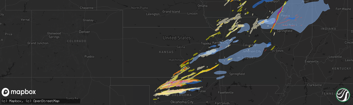
Hail
Tornado
Wind
114,588
Estimated number of impacted properties by a 1.00" hail or larger10,396
Estimated number of impacted properties by a 1.75" hail or larger0
Estimated number of impacted properties by a 2.50" hail or largerStorm reports in Kansas
Kansas
| Date | Description |
|---|---|
| 04/17/20266:18 PM CDT | Downed wires near 200th road. Time estimated from radar. |
| 04/17/20266:15 PM CDT | Downed wires near 1250th road. Time estimated from radar. |
| 04/17/20266:06 PM CDT | Downed wires near massey lane. Time estimated from radar. |
| 04/17/20265:29 PM CDT | Downed wires near 100th terrace. Time confirmed from radar. |
| 04/17/20265:19 PM CDT | Downed tree limbs and wires near craig street. Time confirmed from radar. |
| 04/17/20265:18 PM CDT | 3 inch round tree limbs across roadway. Time estimated based on radar. |
| 04/17/20265:15 PM CDT | Multiple trees down near 223rd street and state line road. Time estimated from radar. |
| 04/17/20265:12 PM CDT | A local report indicates 1.00 inch wind near 6 W Atlanta |
| 04/17/20265:10 PM CDT | Multiple reports of tree limbs and wires down and very strong winds near 223rd and u.s. 69. Time estimated from radar. |
| 04/17/20265:10 PM CDT | Several power poles snapped near 223rd and quivira. Time estimated from radar. |
| 04/17/20265:10 PM CDT | Downed tree limbs and wires near 89th terrace. Time estimated from radar. |
| 04/17/20265:08 PM CDT | Downed wires and power outages near 36th street. Time estimated from radar. |
| 04/17/20265:07 PM CDT | A local report indicates 1.00 inch wind near Hepler |
| 04/17/20265:06 PM CDT | Downed limbs near 119th and pflumm. Time estimated from radar. |
| 04/17/20265:06 PM CDT | Em reports 20 power poles snapped around 223rd and quivira. Time estimated from radar. |
| 04/17/20265:06 PM CDT | Downed limbs and wires near 77th street. Time estimated from radar. |
| 04/17/20265:06 PM CDT | Downed limbs and wires near lackman road. Time estimated from radar. |
| 04/17/20265:04 PM CDT | A local report indicates 67 MPH wind near 1 SSW Spring Hill |
| 04/17/20265:02 PM CDT | Collapsed garage at residence near block road. Time estimated from radar. |
| 04/17/20265:02 PM CDT | Photos of large limbs and branches down from socail media. |
| 04/17/20264:54 PM CDT | Several reports of downed wires and power outages in the osawatomie area. Time estimated from radar. |
| 04/17/20264:52 PM CDT | Downed power lines near 31st street. Time estimated from radar. |
| 04/17/20264:48 PM CDT | Downed wires near pressonville road. Time estimated from radar. |
| 04/17/20264:48 PM CDT | A local report indicates 1.00 inch wind near 5 SW Wellsville |
| 04/17/20264:48 PM CDT | Downed wires near nebraska avenue. Time estimated from radar. |
| 04/17/20264:46 PM CDT | Downed wires and power outages near everett avenue. Time estimated from radar. |
| 04/17/20264:46 PM CDT | Damage to house siding and windows. |
| 04/17/20264:46 PM CDT | A gooseneck travel trailer was tipped over... A chicken coop destroyed... And a metal shed destroyed. |
| 04/17/20264:41 PM CDT | Estimated 60-65 mph wind gusts. |
| 04/17/20264:35 PM CDT | Kowi. Time estimated from radar data. |
| 04/17/20264:28 PM CDT | A local report indicates 1.00 inch wind near 1 S Thayer |
| 04/17/20264:25 PM CDT | With pea size hail. Time estimated from radar data. |
| 04/17/20264:24 PM CDT | Personal weather station. |
| 04/17/20264:15 PM CDT | Tree damage. Time estimated from radar data. |
| 04/17/20264:08 PM CDT | Damage reported to outbuildings around olivet. |
| 04/17/20264:05 PM CDT | Tree damage. |
| 04/17/20263:59 PM CDT | A local report indicates 1.25 inch wind near Mayfield |
| 04/17/20263:57 PM CDT | A local report indicates 1.00 inch wind near 1 WSW Bluff City |
| 04/17/20263:55 PM CDT | Personal weather station. |
| 04/17/20263:54 PM CDT | A local report indicates 1.00 inch wind near 2 WNW Rose Hill |
| 04/17/20263:47 PM CDT | A local report indicates 1.00 inch wind near Potter |
| 04/17/20263:41 PM CDT | Golf ball sized hail sent via mping. |
| 04/17/20263:38 PM CDT | A local report indicates 1.00 inch wind near Derby |
| 04/17/20263:33 PM CDT | A local report indicates 1.00 inch wind near 3 S Haysville |
| 04/17/20263:20 PM CDT | Personal weather station. |
| 04/17/20263:09 PM CDT | Ground covered in peas with quarter size hail mixed in. |
| 04/17/20263:09 PM CDT | Estimated gusts 60-70mph. |
| 04/17/20263:08 PM CDT | Storm chaser observed brief tornado near the intersection of 230th road and sheridan road in atchison county... Ks. Time was approximately 3:08 pm cdt on april 17 as es |
| 04/17/20263:08 PM CDT | Social media report. Time estimated from radar. |
| 04/17/20263:06 PM CDT | A local report indicates 1.00 inch wind near 4 N Towanda |
| 04/17/20263:05 PM CDT | Spotter saw a brief touchdown. |
| 04/17/20263:02 PM CDT | A local report indicates 1.25 inch wind near Conway Springs |
| 04/17/20263:00 PM CDT | A local report indicates 1.25 inch wind near Benton |
| 04/17/20263:00 PM CDT | A local report indicates 1.00 inch wind near 2 WNW Benton |
| 04/17/20262:52 PM CDT | Half dollar hail via mping. |
| 04/17/20262:45 PM CDT | A local report indicates 1.00 inch wind near Burns |
| 04/17/20262:43 PM CDT | A local report indicates 1.00 inch wind near 4 SSE Maize |
| 04/17/20262:36 PM CDT | Mostly pea to penny sized hail with a couple of quarter sized pieces. |
| 04/17/20262:29 PM CDT | A local report indicates 1.00 inch wind near 1 E Valley Falls |
| 04/17/20262:23 PM CDT | Relayed from local fire department. |
| 04/17/20262:20 PM CDT | Pea to ping pong ball sized hail. |
| 04/17/20261:59 PM CDT | A local report indicates 1.50 inch wind near Valley Center |
All States Impacted by Hail Map on April 17, 2026
Cities Impacted by Hail Map on April 17, 2026
- New Ulm, MN
- Lafayette, MN
- Saint Peter, MN
- Nicollet, MN
- Lake Crystal, MN
- Courtland, MN
- Mankato, MN
- Le Sueur, MN
- Kasota, MN
- Eagle Lake, MN
- Henderson, MN
- Cleveland, MN
- Madison Lake, MN
- Elysian, MN
- Waterville, MN
- Le Center, MN
- Gibbon, MN
- Kilkenny, MN
- Janesville, MN
- Montgomery, MN
- Faribault, MN
- Morristown, MN
- Dundas, MN
- Warsaw, MN
- Northfield, MN
- Nerstrand, MN
- Farmington, MN
- Dennison, MN
- Cannon Falls, MN
- Kenyon, MN
- Randolph, MN
- Hampton, MN
- Hastings, MN
- Welch, MN
- Prescott, WI
- River Falls, WI
- Hammond, WI
- Barronett, WI
- Monticello, IA
- Hopkinton, IA
- Anamosa, IA
- Cedar Rapids, IA
- Shell Lake, WI
- Spooner, WI
- Sarona, WI
- Ely, IA
- Mount Vernon, IA
- Cascade, IA
- Swisher, IA
- Dyersville, IA
- Hayfield, MN
- Blooming Prairie, MN
- Austin, MN
- Martelle, IA
- Springville, IA
- Maryville, MO
- New Vienna, IA
- Farley, IA
- West Concord, MN
- Ravenwood, MO
- Parnell, MO
- Bernard, IA
- Epworth, IA
- Peosta, IA
- Kasson, MN
- Pine Island, MN
- Wanamingo, MN
- Zumbrota, MN
- Wyoming, IA
- Center Junction, IA
- Olin, IA
- Dubuque, IA
- Zwingle, IA
- Worthington, IA
- Morley, IA
- Mechanicsville, IA
- Lisbon, IA
- Dodge Center, MN
- Waltham, MN
- Goddard, KS
- Garden Plain, KS
- Isle, MN
- Claremont, MN
- Bolckow, MO
- Byron, MN
- Sandstone, MN
- Valley Center, KS
- Maize, KS
- Colwich, KS
- Wichita, KS
- Newton, KS
- Sedgwick, KS
- Onslow, IA
- La Motte, IA
- Andale, KS
- Sargeant, MN
- Ankeny, IA
- Elkhart, IA
- Barnard, MO
- Guilford, MO
- Whitewater, KS
- Anthony, KS
- Rochester, MN
- Hoyt, KS
- Meriden, KS
- Stewartville, MN
- Valley Falls, KS
- Denison, KS
- Waldron, KS
- West Des Moines, IA
- Cumming, IA
- Red Wing, MN
- Goodhue, MN
- Dexter, MN
- Cheyenne, OK
- Hammon, OK
- Baldwin, IA
- Monmouth, IA
- Maxwell, IA
- Grant City, MO
- Eden Prairie, MN
- Shakopee, MN
- Minneapolis, MN
- Bellevue, IA
- Maquoketa, IA
- Dumont, IA
- Osage, IA
- Clyde, MO
- Conception Junction, MO
- Brook Park, MN
- Hinckley, MN
- Sheridan, MO
- Ackley, IA
- Winfield, KS
- Riceville, IA
- Harper, KS
- Bay City, WI
- Hager City, WI
- Cottonwood Falls, KS
- Strong City, KS
- Ellsworth, WI
- Emporia, KS
- Viola, KS
- Clearwater, KS
- Atchison, KS
- Aplington, IA
- Allison, IA
- Little Cedar, IA
- Stanberry, MO
- Gentry, MO
- Racine, MN
- Newkirk, OK
- Collins, IA
- Arkansas City, KS
- Elbing, KS
- Star Prairie, WI
- Deer Park, WI
- Amery, WI
- Cadott, WI
- Boyd, WI
- Mingo, IA
- Conception, MO
- Bristow, IA
- State Center, IA
- Grand Meadow, MN
- New Richmond, WI
- East Dubuque, IL
- Elmdale, KS
- Rea, MO
- Woodward, OK
- Graham, MO
- Galena, IL
- Stacyville, IA
- McIntire, IA
- Bondurant, IA
- Cambridge, IA
- Argonia, KS
- Danville, KS
- Eyota, MN
- Knoxville, IA
- Cheney, KS
- Burns, KS
- Potwin, KS
- Des Moines, IA
- Mooreland, OK
- Melbourne, IA
- Marshalltown, IA
- Haverhill, IA
- Colo, IA
- Rhodes, IA
- Baxter, IA
- Altoona, IA
- Prairie City, IA
- Mitchellville, IA
- Newton, IA
- Colfax, IA
- Pella, IA
- Reasnor, IA
- Monroe, IA
- Sharon, OK
- Merrillan, WI
- Alma Center, WI
- Dexter, KS
- Burden, KS
- Stanley, WI
- Parkersburg, IA
- De Kalb, MO
- Worth, MO
- Denver, MO
- Van Wert, IA
- Rushville, MO
- Milton, KS
- Conway Springs, KS
- Kechi, KS
- Albany, MO
- Superior, WI
- Chatfield, MN
- Kaw City, OK
- Redding, IA
- King City, MO
- Ponca City, OK
- Cloquet, MN
- Clear Lake, WI
- Elgin, MN
- Alva, OK
- Columbia, IA
- Chariton, IA
- Hanover, IL
- Richland Center, WI
- Muscoda, WI
- Lake City, MN
- Elma, IA
- Orchard, IA
- Excelsior Springs, MO
- Lawson, MO
- Kingston, MO
- Hamilton, MO
- Polo, MO
- Peabody, KS
- Kellogg, IA
- Winchester, KS
- Amorita, OK
- Weston, MO
- Savannah, MO
- Black River Falls, WI
- Florence, KS
- Barnum, MN
- Carlton, MN
- Nortonville, KS
- Humbird, WI
- Fairchild, WI
- South Range, WI
- Corydon, IA
- Benton, KS
- Towanda, KS
- Greenwich, KS
- Saint Joseph, MO
- Amazonia, MO
- Wathena, KS
- Effingham, KS
- Cummings, KS
- Saint Charles, MN
- Dover, MN
- Cedar Point, KS
- La Valle, WI
- Cazenovia, WI
- Reedsburg, WI
- Roberts, WI
- Esko, MN
- Duluth, MN
- Spragueville, IA
- Frontenac, MN
- Plainview, MN
- Cowgill, MO
- Allerton, IA
- Lineville, IA
- Gilman, IA
- Grinnell, IA
- Tama, IA
- North English, IA
- Savanna, IL
- Montour, IA
- Le Grand, IA
- Laurel, IA
- Garwin, IA
- Millville, MN
- Shell Rock, IA
- Waverly, IA
- Shidler, OK
- Maple City, KS
- Cambridge, KS
- Russell, IA
- Martinsville, MO
- Hatfield, MO
- Jamesport, MO
- Chillicothe, MO
- Union Star, MO
- Cedar Vale, KS
- Moline, KS
- Clayton, WI
- Turtle Lake, WI
- Faucett, MO
- Woodburn, IA
- Weldon, IA
- Humeston, IA
- Elizabeth, IL
- Bussey, IA
- Harvey, IA
- Tracy, IA
- Foxboro, WI
- Thorp, WI
- Lublin, WI
- Willard, WI
- Princeton, MO
- Millerton, IA
- Neillsville, WI
- Waynoka, OK
- Americus, KS
- Cosby, MO
- Gilman, WI
- Danbury, WI
- Eagleville, MO
- Darlington, MO
- Helena, MO
- New Hampton, MO
- Freeport, KS
- Trenton, MO
- Scales Mound, IL
- Rayville, MO
- Parnell, IA
- Williamsburg, IA
- Norwalk, WI
- Cashton, WI
- Ontario, WI
- Granton, WI
- Pittsville, WI
- El Dorado, KS
- Braymer, MO
- Breckenridge, MO
- Sedan, KS
- Apple River, IL
- Columbia, MO
- Spring Valley, WI
- Baldwin, WI
- Hillpoint, WI
- Plano, IA
- Melrose, IA
- Cumberland, WI
- Comstock, WI
- Almena, WI
- Elk Falls, KS
- Wilton, WI
- Tomah, WI
- Allen, KS
- Admire, KS
- Chester, OK
- Toledo, IA
- Leighton, IA
- Bethany, MO
- Ridgeway, MO
- Gladbrook, IA
- Mercer, MO
- Galt, MO
- Wilson, WI
- Promise City, IA
- Lovilia, IA
- Arkansaw, WI
- Plum City, WI
- Agency, MO
- Maiden Rock, WI
- Traer, IA
- Ferguson, IA
- Stockton, IL
- Searsboro, IA
- Sully, IA
- Lynnville, IA
- Benton, WI
- Cuba City, WI
- Hudson, WI
- Dacoma, OK
- McFall, MO
- Grenola, KS
- Utica, MN
- Withee, WI
- Norwich, KS
- Cassoday, KS
- Medford, WI
- Kellogg, MN
- Clutier, IA
- New Sharon, IA
- Albia, IA
- Osceola, IA
- Peck, KS
- Wellington, KS
- Aline, OK
- Carmen, OK
- Belle Plaine, KS
- Dearborn, MO
- Longton, KS
- Matfield Green, KS
- Two Harbors, MN
- Silver Bay, MN
- Easton, MO
- Stewartsville, MO
- Hamilton, IA
- Burlington, OK
- Cherokee, OK
- Wabasha, MN
- Altura, MN
- Alma, WI
- Sumner, IA
- Reading, KS
- Bluff City, KS
- Spickard, MO
- Powersville, MO
- Wentzville, MO
- Foristell, MO
- Cainsville, MO
- Blythedale, MO
- Chelsea, IA
- Chili, WI
- Marshfield, WI
- Seymour, IA
- Warrens, WI
- Pacific, MO
- Saint Albans, MO
- Chesterfield, MO
- Wildwood, MO
- Woodville, WI
- Osage City, KS
- Burlingame, KS
- Scranton, KS
- Altoona, KS
- Glenwood City, WI
- Lucerne, MO
- Shullsburg, WI
- Fredonia, KS
- Elk City, KS
- Warren, IL
- Neodesha, KS
- Haysville, KS
- Hazel Green, WI
- Marthasville, MO
- Madison, MO
- Ballwin, MO
- Rollingstone, MN
- Morrison, OK
- Perry, OK
- Lewiston, MN
- Tripoli, IA
- Mulvane, KS
- Cochrane, WI
- Winona, MN
- Minnesota City, MN
- Marion, IA
- Robins, IA
- Hiawatha, IA
- Derby, KS
- Dysart, IA
- Malcom, IA
- Brooklyn, IA
- Lena, IL
- Montezuma, IA
- Eureka, KS
- McConnell, IL
- Kent, IL
- Winslow, IL
- Nora, IL
- Independence, WI
- Rose Hill, KS
- Spencer, WI
- Olpe, KS
- Newtown, MO
- Saint Charles, MO
- Andover, KS
- Milan, KS
- Caldwell, KS
- Mcconnell Afb, KS
- Oregon, MO
- Fillmore, MO
- Eolia, MO
- Silex, MO
- Pearl City, IL
- Manchester, OK
- Clarence, MO
- Excello, MO
- Waterloo, IA
- Labadie, MO
- Pawnee, OK
- Sparta, WI
- Jacksonville, MO
- Amana, IA
- Oxford, IA
- Harris, MO
- Moscow Mills, MO
- Mooresville, MO
- Utica, MO
- Ludlow, MO
- Old Monroe, MO
- Mount Carroll, IL
- Auxvasse, MO
- Mexico, MO
- Thompson, MO
- Fountain City, WI
- Wright City, MO
- Unionville, MO
- Hawkeye, IA
- Lentner, MO
- Stillwater, OK
- Orangeville, IL
- Freeport, IL
- Hartford, KS
- Neosho Rapids, KS
- Lebo, KS
- West Union, IA
- Ossian, IA
- Elgin, IA
- Clermont, IA
- Lime Springs, IA
- North Buena Vista, IA
- Cassville, WI
- Holy Cross, IA
- Osborn, MO
- Arcadia, WI
- Vinton, IA
- Center Point, IA
- Centerville, IA
- Exline, IA
- Saint Louis, MO
- Udall, KS
- Douglass, KS
- Moulton, IA
- Bloomfield, IA
- Unionville, IA
- Drakesville, IA
- Shelbyville, MO
- Leonard, MO
- Clarksville, MO
- Carbondale, KS
- Overbrook, KS
- Easton, KS
- Gower, MO
- Potosi, WI
- Maryland Heights, MO
- Saint Peters, MO
- Stone Lake, WI
- Birchwood, WI
- Mayfield, KS
- Keystone, IA
- Humphreys, MO
- Barnes City, IA
- Fairbank, IA
- Westgate, IA
- Readlyn, IA
- Mystic, IA
- Dunkerton, IA
- Norway, IA
- Arnett, OK
- Palo, IA
- Augusta, KS
- Auburndale, WI
- Arpin, WI
- Sherrill, IA
- Durango, IA
- Castalia, IA
- Cincinnati, IA
- Wakita, OK
- Milladore, WI
- Hewitt, WI
- Novelty, MO
- Madison, KS
- Troy, MO
- Alburnett, IA
- Toddville, IA
- Winfield, MO
- Elsberry, MO
- Foley, MO
- Waverly, KS
- Cedarville, IL
- Dakota, IL
- Monroe, WI
- Lancaster, WI
- Postville, IA
- Rock City, IL
- Juda, WI
- Blair, WI
- Wheeling, MO
- Chula, MO
- Linneus, MO
- Burlington, KS
- Newark, MO
- Knox City, MO
- Bethel, MO
- Taylor, WI
- Independence, KS
- Ferryville, WI
- Eastman, WI
- La Belle, MO
- Cherryvale, KS
- Couderay, WI
- Hayward, WI
- Mineral Point, WI
- Belle Plaine, IA
- Hartwick, IA
- Fayette, IA
- Platteville, WI
- Guttenberg, IA
- Masonville, IA
- Winthrop, IA
- Nebo, IL
- South Wayne, WI
- Gratiot, WI
- Udell, IA
- Walker, IA
- Dodgeville, WI
- Cameron, MO
- Milan, MO
- Pollock, MO
- Mosinee, WI
- Stratford, WI
- Bridgeton, MO
- Earth City, MO
- Darlington, WI
- Laredo, MO
- Plattsburg, MO
- Urbana, IA
- Williamsburg, KS
- Melvern, KS
- Ottumwa, IA
- Eddyville, IA
- Lyndon, KS
- Garnett, KS
- Quenemo, KS
- Davis, IL
- Thayer, KS
- Pomona, KS
- Richmond, KS
- Princeton, KS
- Spring Green, WI
- Barneveld, WI
- Arena, WI
- Ridgeway, WI
- Ridott, IL
- Pecatonica, IL
- Brodhead, WI
- Durand, IL
- Ottawa, KS
- Manchester, IA
- Leon, KS
- Mutual, OK
- Jet, OK
- Tripoli, WI
- Colesburg, IA
- Shellsburg, IA
- Oskaloosa, IA
- Livingston, WI
- Central City, IA
- Brantwood, WI
- Radisson, WI
- Ojibwa, WI
- Milton, IA
- Browning, MO
- Purdin, MO
- Gallatin, MO
- Hedrick, IA
- Galesburg, KS
- Erie, KS
- Saint Paul, KS
- Baldwin City, KS
- Lawrence, KS
- Osseo, WI
- Helena, OK
- Beloit, WI
- Rockton, IL
- Winnebago, IL
- Rantoul, KS
- Osawatomie, KS
- Lane, KS
- Greeley, KS
- Wellsville, KS
- Paola, KS
- Edgar, WI
- Exeland, WI
- Athens, WI
- Merrill, WI
- Coggon, IA
- Hixton, WI
- Williamstown, MO
- Kahoka, MO
- Wyaconda, MO
- Griggsville, IL
- Chambersburg, IL
- Versailles, IL
- Chanute, KS
- Glen Haven, WI
- Parsons, KS
- Westphalia, KS
- Howard, KS
- Lock Springs, MO
- Rewey, WI
- Ladora, IA
- Marengo, IA
- Hillview, IL
- Winchester, IL
- Roodhouse, IL
- Argyle, WI
- Browntown, WI
- Kansas City, MO
- Martinsburg, IA
- Montfort, WI
- Winter, WI
- Mission, KS
- Kansas City, KS
- Shawnee, KS
- Stitzer, WI
- Rosalia, KS
- Nash, OK
- Keosauqua, IA
- Douds, IA
- Meredosia, IL
- Gardner, KS
- Eldon, IA
- Floris, IA
- Severy, KS
- Kidder, MO
- Tomahawk, WI
- Hazelhurst, WI
- Edgerton, KS
- Spring Hill, KS
- Pond Creek, OK
- Walnut, KS
- Eudora, KS
- Olathe, KS
- De Soto, KS
- Schofield, WI
- Ringle, WI
- Fairview, OK
- Monticello, WI
- Rockford, IL
- Shirland, IL
- South Beloit, IL
- Cobb, WI
- Highland, WI
- Williamson, IA
- Selma, IA
- Frederick, IL
- Lenexa, KS
- Langworthy, IA
- Wayland, MO
- Independence, MO
- Oxford, KS
- Beardstown, IL
- Mount Sterling, IL
- Green Castle, MO
- Winigan, MO
- Green City, MO
- Skidmore, MO
- Moravia, IA
- Jacksonville, IL
- Fall River, KS
- Rushville, IL
- Mapleton, KS
- Uniontown, KS
- Anabel, MO
- Arenzville, IL
- Goltry, OK
- Bloomington, WI
- Bonaparte, IA
- Donnellson, IA
- Farmington, IA
- Glidden, WI
- Irma, WI
- Stark, KS
- Garrison, IA
- Prairieburg, IA
- Hepler, KS
- Farlington, KS
- Fort Scott, KS
- Louisburg, KS
- Bucyrus, KS
- Butternut, WI
- Park Falls, WI
- Overland Park, KS
- Leawood, KS
- Prairie Village, KS
- Grandview, MO
- Cleveland, MO
- Stilwell, KS
- Belton, MO
- Verona, WI
- Mount Horeb, WI
- Medford, OK
- Rock, KS
- Cleo Springs, OK
- Atlanta, KS
- Janesville, WI
- Liberty, MO
- Browning, IL
- Astoria, IL
- West Point, IA
- Girard, KS
- Edina, MO
- Lake Tomahawk, WI
- Eagle River, WI
- Butler, MO
- Pleasant Hill, MO
- Kingsville, MO
- Burlington Junction, MO
- Redfield, KS
- Belleville, WI
- Lime Ridge, WI
- Albany, WI
- Junction City, WI
- Springbrook, WI
- Mellen, WI
- Wauzeka, WI
- Black Earth, WI
- Evansville, WI
- Roscoe, IL
- Gays Mills, WI
- Benedict, KS
- Checotah, OK
- Riverside, IA
- Washington, IA
- Clinton, WI
- Nichols, IA
- Wellman, IA
- Ollie, IA
- Richland, IA
- West Chester, IA
- Brighton, IA
- Columbus Junction, IA
- Ainsworth, IA
- Lone Tree, IA
- Packwood, IA
- Iowa City, IA
- Keota, IA
- Conesville, IA
- Kalona, IA
- Fairfield, IA
- Raymore, MO
- Blue Springs, MO
- Buckner, MO
- Lees Summit, MO
- West Liberty, IA
- Grain Valley, MO
- Oak Grove, MO
- Ringwood, OK
- Harrisonville, MO
- Freeman, MO
- Peculiar, MO
- Greenwood, MO
- Deerfield, WI
- Marshall, WI
- Waterloo, WI
- Latham, KS
- Orfordville, WI
- Ipava, IL
- Cuba, IL
- Smithfield, IL
- Vermont, IL
- Lewistown, IL
- New Glarus, WI
- Sibley, MO
- Laclede, MO
- Rutledge, MO
- Boscobel, WI
- Steuben, WI
- Savonburg, KS
- Walker, MO
- Centerview, MO
- Warrensburg, MO
- Mayview, MO
- Holden, MO
- Odessa, MO
- Ewing, MO
- Avalon, WI
- Darien, WI
- Sharon, WI
- Solon, IA
- Napoleon, MO
- Bates City, MO
- Wellington, MO
- Levasy, MO
- Carrier, OK
- Camden, MO
- Richmond, MO
- Henrietta, MO
- Orrick, MO
- Lexington, MO
- Ellisville, IL
- Fairview, IL
- London Mills, IL
- Canton, IL
- Deer Creek, OK
- Footville, WI
- Milton, WI
- Higginsville, MO
- Dover, MO
- Wilton, IA
- Tipton, IA
- Atalissa, IA
- Moscow, IA
- Hardin, MO
- Norborne, MO
- Waverly, MO
- Maquon, IL
- Farmington, IL
- Johnson Creek, WI
- Watertown, WI
- Novinger, MO
- Lewistown, MO
- Blue Mounds, WI
- New Boston, MO
- Brookfield, MO
- Kirksville, MO
- Lenox, IA
- Belmont, WI
- Buffalo, KS
- Yates City, IL
- Delavan, WI
- Whitewater, WI
- Enid, OK
- Sumner, MO
- Marceline, MO
- Bucklin, MO
- New Cambria, MO
- Lone Jack, MO
- Strasburg, MO
- La Plata, MO
- Ethel, MO
- Elmer, MO
- Atlanta, MO
- Macon, MO
- Bevier, MO
- Callao, MO
- Waunakee, WI
- Cross Plains, WI
- Middleton, WI
- Brimfield, IL
- Elmwood, IL
- Gilson, IL
- Dahinda, IL
- Williamsfield, IL
- Monticello, MO
- Afton, WI
- Saint Patrick, MO
- Canton, MO
- Rich Hill, MO
- Braman, OK
- South Haven, KS
- Laura, IL
- Nevada, MO
- Alma, MO
- Blackburn, MO
- Kremlin, OK
- Carrollton, MO
- Meno, OK
- Lahoma, OK
- Walcott, IA
- Muscatine, IA
- Stockton, IA
- Durant, IA
- Blue Grass, IA
- Davenport, IA
- Toulon, IL
- Princeville, IL
- Speer, IL
- Mercer, WI
- Rockville, MO
- Schell City, MO
- Harwood, MO
- Lamont, OK
- Warsaw, IL
- Geuda Springs, KS
- Brashear, MO
- Winterset, IA
- Juneau, WI
- Lebanon, WI
- Seiling, OK
- Dexter, IA
- Orient, IA
- Greenfield, IA
- Raritan, IL
- Media, IL
- Palmyra, WI
- Nauvoo, IL
- La Fayette, IL
- Wyoming, IL
- Appleton City, MO
- Osceola, MO
- Hunter, OK
- Bettendorf, IA
- Long Grove, IA
- Princeton, IA
- Le Claire, IA
- Eldridge, IA
- West Point, IL
- Sutter, IL
- Van Meter, IA
- Adel, IA
- Taloga, OK
- Vici, OK
- Urbandale, IA
- Clive, IA
- Basco, IL
- Booneville, IA
- Waukee, IA
- Earlham, IA
- Fort Atkinson, WI
- Nardin, OK
- Rubicon, WI
- Neosho, WI
- Johnston, IA
- Buda, IL
- Bradford, IL
- Neponset, IL
- Gibbs, MO
- Hurdland, MO
- Tonkawa, OK
- Blackwell, OK
- Wyanet, IL
- Garber, OK
- Billings, OK
- Red Rock, OK
- Camanche, IA
- De Witt, IA
- Clinton, IA
- McCausland, IA
- Low Moor, IA
- Biggsville, IL
- Lomax, IL
- Ixonia, WI
- Monmouth, IL
- Oquawka, IL
- Grimes, IA
- Alexandria, MO
- Montrose, IA
- Keokuk, IA
- Carthage, IL
- Lowry City, MO
- Dallas City, IL
- Sheffield, IL
- Princeton, IL
- Prescott, KS
- Hume, MO
- Fulton, KS
- Richards, MO
- Elkhorn, WI
- Walnut, IL
- El Dorado Springs, MO
- Milo, MO
- Harshaw, WI
- Cairo, MO
- Melrose, WI
- Hamilton, IL
- Deepwater, MO
- Roseville, IL
- Isabella, OK
- Tiskilwa, IL
- Shelbina, MO
- Moberly, MO
- Cameron, IL
- Smithshire, IL
- Kirkwood, IL
- Jefferson, WI
- Philadelphia, MO
- Mendon, IL
- La Harpe, IL
- East Troy, WI
- Burbank, OK
- Marland, OK
- Longdale, OK
- Okeene, OK
- Leaf River, IL
- German Valley, IL
- Canton, OK
- Blandinsville, IL
- Ames, OK
- Eureka, MO
- Eagle, WI
- Knoxville, IL
- Bowen, IL
- Plymouth, IL
- La Grange, MO
- Elvaston, IL
- Ursa, IL
- Niota, IL
- Argyle, IA
- Loraine, IL
- La Prairie, IL
- Clayton, IL
- Golden, IL
- Camp Point, IL
- Augusta, IL
- Tennessee, IL
- Timewell, IL
- Huntsville, IL
- Colchester, IL
- Camden, IL
- Macomb, IL
- Good Hope, IL
- Industry, IL
- Sciota, IL
- Littleton, IL
- Bushnell, IL
- Leedey, OK
- Victoria, IL
- Southard, OK
- Palmyra, MO
- Mukwonago, WI
- Saint Germain, WI
- Woodruff, WI
- Adair, IL
- Marietta, IL
- Prairie City, IL
- Bardolph, IL
- Table Grove, IL
- De Soto, IA
- Waterford, WI
- Fairfax, OK
- Pawhuska, OK
- Fowler, IL
- Quincy, IL
- Coatsburg, IL
- Paloma, IL
- Liberty, IL
- Kingfisher, OK
- Hennessey, OK
- Saint Augustine, IL
- Avon, IL
- Abingdon, IL
- Galesburg, IL
- Waukomis, OK
- Montrose, MO
- Clinton, MO
- Caledonia, IL
- Harvard, IL
- Poplar Grove, IL
- Chana, IL
- Camargo, OK
- Burlington, WI
- Bartlesville, OK
- Ashton, IL
- Franklin Grove, IL
- Oregon, IL
- Collins, MO
- Gravois Mills, MO
- Wheatland, MO
- Versailles, MO
- Rocky Mount, MO
- Climax Springs, MO
- Lincoln, MO
- Edwards, MO
- Eldon, MO
- Quincy, MO
- Stover, MO
- Warsaw, MO
- Barnett, MO
- Cross Timbers, MO
- Hermitage, MO
- Macks Creek, MO
- Roach, MO
- Camdenton, MO
- Sunrise Beach, MO
- Lake Ozark, MO
- Latham, MO
- Syracuse, MO
- Mora, MO
- Tipton, MO
- Cole Camp, MO
- Calhoun, MO
- Windsor, MO
- Fortuna, MO
- Smithton, MO
- Florence, MO
- Ionia, MO
- Otterville, MO
- Bison, OK
- Havana, IL
- Bath, IL
- Chandlerville, IL
- Virginia, IL
- Chapin, IL
- Bryant, IL
- Glasford, IL
- Trivoli, IL
- Liverpool, IL
- Saint David, IL
- Norris, IL
- Forreston, IL
- Cherry Valley, IL
- Dixon, IL
- Belvidere, IL
- Clare, IL
- Esmond, IL
- Byron, IL
- Holcomb, IL
- Woosung, IL
- Rochelle, IL
- Monroe Center, IL
- Kirkland, IL
- Kingston, IL
- Sterling, IL
- Mount Morris, IL
- Polo, IL
- Davis Junction, IL
- Lindenwood, IL
- Stillman Valley, IL
- Oakwood, OK
- Russellville, MO
- Kaiser, MO
- Osage Beach, MO
- Eugene, MO
- Clarksburg, MO
- Olean, MO
- Ulman, MO
- Iberia, MO
- Tuscumbia, MO
- California, MO
- Lohman, MO
- Centertown, MO
- New Bloomfield, MO
- Jefferson City, MO
- Ashland, MO
- Henley, MO
- Jamestown, MO
- Saint Elizabeth, MO
- Hartsburg, MO
- Preston, MO
- Capron, IL
- Walworth, WI
- Big Bend, WI
- Waukesha, WI
- Lake Geneva, WI
- Richmond, IL
- Union, IL
- Sycamore, IL
- Union Grove, WI
- Hebron, IL
- Muskego, WI
- Garden Prairie, IL
- Salem, WI
- Fontana, WI
- Williams Bay, WI
- Woodstock, IL
- Marengo, IL
- Kansasville, WI
- Genoa City, WI
- Genoa, IL
- Loves Park, IL
- Twin Lakes, WI
- Franksville, WI
- Machesney Park, IL
- Wonder Lake, IL
- Chillicothe, IL
- Peoria, IL
- Peoria Heights, IL
- East Peoria, IL
- Easton, IL
- Topeka, IL
- Kilbourne, IL
- Hanna City, IL
- Dunlap, IL
- Metamora, IL
- Mapleton, IL
- Mossville, IL
- Edwards, IL
- Kingston Mines, IL
- Manito, IL
- Forest City, IL
- Caledonia, WI
- Mason City, IL
- Pekin, IL
- Edelstein, IL
- Washington, IL
- Lowpoint, IL
- Creve Coeur, IL
- Douglas, OK
- Marshall, OK
- Butler, OK
- Holts Summit, MO
- Tebbetts, MO
- Fulton, MO
- Meta, MO
- Westphalia, MO
- Saint Thomas, MO
- Bonnots Mill, MO
- Koeltztown, MO
- Argyle, MO
- Sparland, IL
- Granville, IL
- Henry, IL
- Putnam, IL
- Hennepin, IL
- Spring Valley, IL
- Watonga, OK
- Ladd, IL
- Depue, IL
- Seatonville, IL
- Bureau, IL
- Malden, IL
- La Moille, IL
- Arlington, IL
- Mendota, IL
- Compton, IL
- Dover, IL
- Ohio, IL
- West Brooklyn, IL
- Sublette, IL
- Kewanee, IL
- Galva, IL
- Altona, IL
- Wataga, IL
- Oneida, IL
- East Galesburg, IL
- Berwick, IL
- Hitchcock, OK
- San Jose, IL
- Green Valley, IL
- Lucien, OK
- Orlando, OK
- Covington, OK
- South Pekin, IL
- Silver Lake, WI
- Oak Creek, WI
- Spring Grove, IL
- Sturtevant, WI
- Racine, WI
- Franklin, WI
- Ringwood, IL
- Kenosha, WI
- Trevor, WI
- Bristol, WI
- Antioch, IL
- Wilmot, WI
- Mchenry, IL
- Lake Villa, IL
- Huntley, IL
- Ingleside, IL
- Crystal Lake, IL
- Fox Lake, IL
- Pleasant Prairie, WI
- Oakford, IL
- Ashland, IL
- Washburn, IL
- Pleasant Plains, IL
- Lacon, IL
- Cherry, IL
- Greenview, IL
- Mark, IL
- Dalzell, IL
- Petersburg, IL
- Groveland, IL
- Tallula, IL
- Oglesby, IL
- Standard, IL
- Triumph, IL
- Toluca, IL
- La Salle, IL
- Cedar Point, IL
- Peru, IL
- La Rose, IL
- McNabb, IL
- Earlville, IL
- Tremont, IL
- Waterman, IL
- Delavan, IL
- Wenona, IL
- Troy Grove, IL
- Leland, IL
- Magnolia, IL
- Morton, IL
- Lostant, IL
- Tonica, IL
- Ottawa, IL
- Paw Paw, IL
- Varna, IL
- Utica, IL
- Lake In The Hills, IL
- Hampshire, IL
- Freeburg, MO
- Vienna, MO
- Loose Creek, MO
- Linn, MO
- Eureka, IL
- Roanoke, IL
- Shabbona, IL
- Somonauk, IL
- Hinckley, IL
- Deer Creek, IL
- Hopedale, IL
- Dover, OK
- Middletown, IL
- New Holland, IL
- Minier, IL
- Sheridan, IL
- Minonk, IL
- Athens, IL
- Emden, IL
- Cantrall, IL
- Mackinaw, IL
- Lee, IL
- Dekalb, IL
- Maple Park, IL
- Sandwich, IL
- Malta, IL
- Streator, IL
- Leonore, IL
- Grand Ridge, IL
- Dana, IL
- Benson, IL
- Danvers, IL
- Carlock, IL
- Goodfield, IL
- Congerville, IL
- Hartsburg, IL
- El Paso, IL
- Armington, IL
- Rutland, IL
- Stanford, IL
- Secor, IL
- Kingdom City, MO
- Belle, MO
- Mokane, MO
- Marseilles, IL
- Wedron, IL
- Serena, IL
- Ancona, IL
- Seneca, IL
- Long Point, IL
- Chamois, MO
- Zion, IL
- Round Lake, IL
- Island Lake, IL
- Wauconda, IL
- Wadsworth, IL
- Springfield, IL
- Elkhart, IL
- Atlanta, IL
- Lincoln, IL
- Sherman, IL
- Williamsville, IL
- Steedman, MO
- Hermann, MO
- Owensville, MO
- Bland, MO
- Morrison, MO
- Mount Sterling, MO
- Portland, MO
- Williamsburg, MO
- Rhineland, MO
- Sayre, OK
- Elk City, OK
- Glencoe, OK
- Crescent, OK
- Montgomery City, MO
- Cornell, IL
- Millbrook, IL
- Ransom, IL
- Millington, IL
- Flanagan, IL
- Yorkville, IL
- Big Rock, IL
- Morris, IL
- Plano, IL
- Newark, IL
- Bristol, IL
- Sugar Grove, IL
- Aurora, IL
- Montgomery, IL
- Downs, IL
- Le Roy, IL
- Ellsworth, IL
- McLean, IL
- Wapella, IL
- Warrensburg, IL
- Buffalo, IL
- Lexington, IL
- Chenoa, IL
- Niantic, IL
- Lawndale, IL
- Mount Pulaski, IL
- Beason, IL
- Clinton, IL
- Hudson, IL
- Shirley, IL
- Illiopolis, IL
- Normal, IL
- Kenney, IL
- Waynesville, IL
- Graymont, IL
- Pontiac, IL
- Towanda, IL
- Heyworth, IL
- Latham, IL
- Chestnut, IL
- Bloomington, IL
- Maroa, IL
- Blackstone, IL
- Gridley, IL
- Riverton, IL
- Mulhall, OK
- Yale, OK
- Maramec, OK
- Jennings, OK
- Cleveland, OK
- Coyle, OK
- Guthrie, OK
- Terlton, OK
- Hominy, OK
- Wellsville, MO
- Jonesburg, MO
- Bellflower, MO
- New Florence, MO
- Middletown, MO
- Berger, MO
- High Hill, MO
- Warrenton, MO
- Rosebud, MO
- Martinsburg, MO
- New Haven, MO
- Gerald, MO
- Truxton, MO
- Verona, IL
- Cooksville, IL
- Plainfield, IL
- Oswego, IL
- Odell, IL
- Kinsman, IL
- Minooka, IL
- Mazon, IL
- Dwight, IL
- Colfax, IL
- Oreana, IL
- Lane, IL
- Decatur, IL
- Arrowsmith, IL
- Fairbury, IL
- Dewitt, IL
- Farmer City, IL
- Argenta, IL
- Forsyth, IL
- Weldon, IL
- Fairmont, OK
- Osage, OK
- Prue, OK
- Joliet, IL
- Cabery, IL
- Emington, IL
- Channahon, IL
- Cropsey, IL
- Forrest, IL
- Elwood, IL
- Anchor, IL
- Braidwood, IL
- Reddick, IL
- Buckingham, IL
- Cullom, IL
- Gardner, IL
- Braceville, IL
- Campus, IL
- Essex, IL
- Shorewood, IL
- Wilmington, IL
- South Wilmington, IL
- Saunemin, IL
- Coal City, IL
- Sand Springs, OK
- Skiatook, OK
- Mansfield, IL
- Ivesdale, IL
- Cerro Gordo, IL
- Milmine, IL
- Monticello, IL
- Gibson City, IL
- Foosland, IL
- Melvin, IL
- Sibley, IL
- Piper City, IL
- Strawn, IL
- Chatsworth, IL
- Seymour, IL
- White Heath, IL
- De Land, IL
- Dewey, IL
- Fisher, IL
- Cisco, IL
- Mahomet, IL
- Saybrook, IL
- Kempton, IL
- Bellflower, IL
- Champaign, IL
- Atwood, IL
- La Place, IL
- Lovington, IL
- Hammond, IL
- Bement, IL
- Roberts, IL
- Bonfield, IL
- Union Hill, IL
- Herscher, IL
- Corn, OK
- Manhattan, IL
- Bondville, IL
- Arthur, IL
- Clifton, IL
- Elliott, IL
- Hawk Point, MO
- Truesdale, MO
- Hydro, OK
- Colony, OK
- O'Fallon, MO
- Urbana, IL
- Kankakee, IL
- Thomasboro, IL
- Pesotum, IL
- Gifford, IL
- Ogden, IL
- Tolono, IL
- Tuscola, IL
- Rankin, IL
- Royal, IL
- Buckley, IL
- Homer, IL
- Onarga, IL
- Thawville, IL
- Villa Grove, IL
- Danforth, IL
- Chebanse, IL
- Loda, IL
- Saint Joseph, IL
- Rantoul, IL
- Savoy, IL
- Philo, IL
- Cissna Park, IL
- Manteno, IL
- Paxton, IL
- Gilman, IL
- Sadorus, IL
- Ludlow, IL
- Sidney, IL
- Penfield, IL
- Ashkum, IL
- Longview, IL
- Arcola, IL
- Broadlands, IL
- Fairmount, IL
- Potomac, IL
- Crescent City, IL
- Collison, IL
- Milford, IL
- Fithian, IL
- Rossville, IL
- Armstrong, IL
- Bourbonnais, IL
- Danville, IL
- Hoopeston, IL
- Watseka, IL
- Oakwood, IL
- Monee, IL
- Saint Anne, IL
- Beecher, IL
- Pembroke Township, IL
- Grant Park, IL
- Papineau, IL
- Wellington, IL
- Bradley, IL
- Martinton, IL
- Frankfort, IL
- Crete, IL
- University Park, IL
- Aroma Park, IL
- Momence, IL
- Peotone, IL
- Mangum, OK
- Columbus, KS
- Scammon, KS
- Cherokee, KS
- McCune, KS
- West Mineral, KS
- Pittsburg, KS
- Weir, KS
- Galena, KS
- Carl Junction, MO
- Jasper, MO
- Carthage, MO
- Opolis, KS
- Asbury, MO
- Purcell, MO
- Oronogo, MO
- Neck City, MO
- Webb City, MO
- Alba, MO
- Golden City, MO
- Reeds, MO
- Dyer, IN
- Saint John, IN
- Sheldon, IL
- Morocco, IN
- Lake Village, IN
- Schneider, IN
- Crown Point, IN
- Cedar Lake, IN
- Schererville, IN
- Beaverville, IL
- Donovan, IL
- Iroquois, IL
- Lowell, IN
- Brook, IN
- Merrillville, IN
- Kentland, IN
- Demotte, IN
- Henning, IL
- Fowler, IN
- Bismarck, IL
- Earl Park, IN
- Ambia, IN
- Stockland, IL
- Alvin, IL
- Hebron, IN
- Muncie, IL
- Williamsport, IN
- Rensselaer, IN
- Boone Grove, IN
- Valparaiso, IN
- Fair Oaks, IN
- Mount Ayr, IN
- Shelby, IN
- Hobart, IN
- Thayer, IN
- Goodland, IN
- Wheatfield, IN
- West Lebanon, IN
- Attica, IN
- Pine Village, IN
- Wolcott, IN
- Monon, IN
- Francesville, IN
- Kouts, IN
- Boswell, IN
- Brookston, IN
- Reynolds, IN
- Oxford, IN
- Templeton, IN
- Otterbein, IN
- Remington, IN
- Medaryville, IN
- Chalmers, IN
- Duke, OK
- West Lafayette, IN
- Washington, MO
- San Pierre, IN
- La Crosse, IN
- Wanatah, IN
- Westville, IN
- Winamac, IN
- North Judson, IN
- Monticello, IN
- Miami, OK
- Picher, OK
- Quapaw, OK
- Commerce, OK
- Joplin, MO
- Seneca, MO
- Neosho, MO
- Wyandotte, OK
- Diamond, MO
- Sarcoxie, MO
- Altus, OK
- Olustee, OK
- Hanna, IN
- Star City, IN
- Union Mills, IN
- Michigan City, IN
- La Porte, IN
- Knox, IN
- Hamlet, IN
- Kingsford Heights, IN
- Grovertown, IN
- Ora, IN
- Monterey, IN
- Rochester, IN
- Kewanna, IN
- Culver, IN
- Plymouth, IN
- Argos, IN
- Throckmorton, TX
- Woodson, TX
- Albany, TX
- Newcastle, TX
- Olney, TX
- Breckenridge, TX
- Abilene, TX
- Corder, MO
- Malta Bend, MO
- Marshall, MO
- Miami, MO
- Caddo, OK
- Durant, OK
- Calera, OK
- Bokchito, OK
- Fay, OK
- Bennington, OK
- Boswell, OK
- Soper, OK
- Hugo, OK
- Sterling City, TX
- Robert Lee, TX
- Blackwell, TX
- Big Lake, TX
- Garden City, TX
- Lawn, TX
- Goldsboro, TX
- Ovalo, TX
- Mertzon, TX
- Clyde, TX
- Cross Plains, TX
- Baird, TX
- Clio, IA
- Berwick, IA
- Prole, IA
- Beldenville, WI
- North Aurora, IL
- Mokena, IL
- Lemont, IL
- La Grange, IL
- Woodridge, IL
- Villa Park, IL
- Palos Hills, IL
- Wheaton, IL
- Harwood Heights, IL
- Bridgeview, IL
- Clarendon Hills, IL
- Burbank, IL
- Franklin Park, IL
- Lombard, IL
- Chicago, IL
- Justice, IL
- Skokie, IL
- Lincolnwood, IL
- Lyons, IL
- Oak Park, IL
- River Grove, IL
- Elmhurst, IL
- Crest Hill, IL
- Bellwood, IL
- Stone Park, IL
- Evanston, IL
- Glendale Heights, IL
- Hillside, IL
- Westchester, IL
- West Chicago, IL
- Palos Park, IL
- Park Ridge, IL
- Naperville, IL
- Wood Dale, IL
- Wilmette, IL
- Elburn, IL
- Brookfield, IL
- Lisle, IL
- Berkeley, IL
- Carol Stream, IL
- River Forest, IL
- Hickory Hills, IL
- Hines, IL
- Downers Grove, IL
- Bolingbrook, IL
- Broadview, IL
- Morton Grove, IL
- Maywood, IL
- Geneva, IL
- Bensenville, IL
- Winfield, IL
- Warrenville, IL
- Romeoville, IL
- Homer Glen, IL
- Schiller Park, IL
- Cicero, IL
- Itasca, IL
- La Grange Park, IL
- Niles, IL
- Mooseheart, IL
- Darien, IL
- Bloomingdale, IL
- Riverside, IL
- Willowbrook, IL
- Berwyn, IL
- Des Plaines, IL
- Westmont, IL
- Hinsdale, IL
- Glen Ellyn, IL
- Hanover Park, IL
- Willow Springs, IL
- Summit Argo, IL
- Orland Park, IL
- Medinah, IL
- Lockport, IL
- New Lenox, IL
- Oak Brook, IL
- Addison, IL
- Elmwood Park, IL
- Western Springs, IL
- Forest Park, IL
- Elk Grove Village, IL
- Melrose Park, IL
- Batavia, IL
- Saint Charles, IL
- Bartlett, IL
- Wayne, IL
- Roselle, IL
- Golf, IL
- Glenview, IL
- Worth, IL
- Evergreen Park, IL
- Hometown, IL
- Crestwood, IL
- Tinley Park, IL
- Alsip, IL
- Oak Lawn, IL
- Palos Heights, IL
- Midlothian, IL
- Chicago Ridge, IL
- Oak Forest, IL
- Robbins, IL
- Blue Island, IL
- Turney, MO
- Mount Prospect, IL
- Arlington Heights, IL
- Harpers Ferry, IA
- Woodman, WI
- Mount Hope, WI
- Peterson, MN
- Lanesboro, MN
- Newhall, IA
- Atkins, IA
- Watkins, IA
- Van Horne, IA
- Blairstown, IA
- Milledgeville, IL
- Lyndon, IL
- Fulton, IL
- Hillsdale, IL
- Albany, IL
- Goose Lake, IA
- Fenton, IL
- Cordova, IL
- Lanark, IL
- Thomson, IL
- Erie, IL
- Wayland, IA
- Chadwick, IL
- Morrison, IL
- Port Byron, IL
- Sabula, IA
- Shannon, IL
- Donahue, IA
- Dixon, IA
- Gladstone, IL
- Wever, IA
- Carman, IL
- Stronghurst, IL
- Burlington, IA
- New Liberty, IA
- Grand Mound, IA
- Mediapolis, IA
- Wapello, IA
- Sperry, IA
- Oakville, IA
- Taylor Ridge, IL
- Aledo, IL
- New Boston, IL
- Little York, IL
- Joy, IL
- Seaton, IL
- Keithsburg, IL
- Alexis, IL
- Reynolds, IL
- Gerlaw, IL
- North Henderson, IL
- Milan, IL
- Viola, IL
- New Windsor, IL
- Sherrard, IL
- Matherville, IL
- Illinois City, IL
- Morning Sun, IA
- Geneseo, IL
- Coal Valley, IL
- Colona, IL
- Orion, IL
- Lynn Center, IL
- Osco, IL
- Ophiem, IL
- Alpha, IL
- Andover, IL
- Cambridge, IL
- Rio, IL
- Woodhull, IL
- Bishop Hill, IL
- Henderson, IL
- East Moline, IL
- Moline, IL
- Silvis, IL
- Rock Island, IL
- Pittsfield, IL
- Pleasant Hill, IL
- Bluffs, IL
- Patterson, IL
- Concord, IL
- Wingate, TX
- Maryneal, TX
- Merkel, TX
- Tuscola, TX
- Bronte, TX
- Nolan, TX
- McGregor, IA
- Prairie Du Chien, WI
- Lansing, IA
- Wausau, WI
- South Bend, IN


