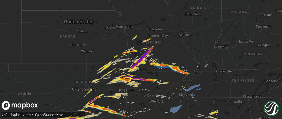
Hail Map on April 28, 2026
The weather event on April 28, 2026 includes Hail, Tornado, and Wind maps. 10 states and 939 cities were impacted and suffered possible damage. The total estimated number of properties impacted is 525,142.
Hail
Tornado
Wind
525,142
Estimated number of impacted properties by a 1.00" hail or larger211,176
Estimated number of impacted properties by a 1.75" hail or larger194,978
Estimated number of impacted properties by a 2.50" hail or largerStates Impacted by Hail Map on April 28, 2026
Storm reports
Missouri
| Date | Description |
|---|---|
| 04/28/20265:38 PM CDT | Ping pong to golf ball size hail in holocomb. |
| 04/28/20265:36 PM CDT | Tree over the road south of campbell. |
| 04/28/20265:15 PM CDT | Asos station kpof poplar bluff mo. |
| 04/28/20265:05 PM CDT | A local report indicates 70 MPH wind near Neelyville |
| 04/28/20265:05 PM CDT | Outbuilding blown into a house... Trees and power lines down. Power poles snapped on highway 142 just south of naylor. |
| 04/28/20265:00 PM CDT | Tractor trailer blown over on us 67 one mile north of the arkansas state line. |
| 04/28/20264:55 PM CDT | Large trees down in oxly. |
| 04/28/20264:49 PM CDT | Power pole down on highway h just south of naylor. Time estimated. |
| 04/28/20264:46 PM CDT | Damage to a barn and pickup truck on highway h between county roads h-5 and h-3. Time estimated. |
| 04/28/20264:45 PM CDT | A local report indicates 1.00 inch wind near Doniphan |
| 04/28/20264:45 PM CDT | Several trees down in oxly. Time estimated. |
| 04/28/20264:45 PM CDT | A local report indicates 2.00 inch wind near Doniphan |
| 04/28/20264:43 PM CDT | A local report indicates 1.00 inch wind near 1 N Doniphan |
| 04/28/20264:43 PM CDT | A local report indicates 1.75 inch wind near 2 N Doniphan |
| 04/28/20264:43 PM CDT | Large trees uprooted and large limbs down on county road 142e30 south of oxly. Time estimated. |
| 04/28/20264:41 PM CDT | 60 mph wind gust and pea sized hail. |
| 04/28/20264:41 PM CDT | Large tree snapped. |
| 04/28/20264:38 PM CDT | Several hailstones photographed around 1-1.5in... With one elongated hailstone up to 2.5in. |
| 04/28/20264:38 PM CDT | Roof and siding damage to a home on county road 142-e8. Time estimated from radar. |
| 04/28/20264:37 PM CDT | Reported on highway 21 on the carter/ripley county line. |
| 04/28/20263:39 PM CDT | Quarter size hail 9 miles southwest of mtn view mo... Howell county... Spotter report. |
| 04/28/20263:38 PM CDT | Several trees down 17 highway north of west plains... Howell co... North of white church. |
| 04/28/20263:38 PM CDT | Large trees down. |
| 04/28/20263:37 PM CDT | A local report indicates 1.75 inch wind near 4 SSE Pomona |
| 04/28/20263:35 PM CDT | Tree fell on house. Large branches off of trees. |
| 04/28/20263:35 PM CDT | 6-8 inch tree limbs down in west plains at cc and christopher drive. |
| 04/28/20263:34 PM CDT | Tree down across the road on co rd 4870... Howell county. |
| 04/28/20263:34 PM CDT | A local report indicates 1.75 inch wind near Pomona |
| 04/28/20263:33 PM CDT | A local report indicates 60 MPH wind near Pomona |
| 04/28/20263:30 PM CDT | Large tree down. |
| 04/28/20263:00 PM CDT | A report of tree down 95 hwy just north of gentryville in douglas county. Road blocked. |
| 04/28/20262:59 PM CDT | Tree down on the e side of co rd zz 137 off e 76 hwy. |
| 04/28/20262:58 PM CDT | Douglas county has had a report of a tree on c hwy north of skyline school... About 4 miles. |
| 04/28/20262:29 PM CDT | A local report indicates 1.50 inch wind near 3 N Gravois Mills |
| 04/28/20262:05 PM CDT | Report from mping half dollar 1.25 inches. |
| 04/28/20261:55 PM CDT | Report from mping quarter 1.00 inch. |
| 04/28/20261:54 PM CDT | Report from mping quarter 1.00 inch. |
| 04/28/20261:48 PM CDT | Amateur radio reports quarter size hail in nixa. |
| 04/28/20261:47 PM CDT | Report from mping quarter 1.00 inch. |
| 04/28/20261:47 PM CDT | A local report indicates 1.00 inch wind near 3 NE Boaz |
| 04/28/20261:46 PM CDT | Report from mping quarter 1.00 inch. |
| 04/28/20261:37 PM CDT | Off duty officer reports golf ball sized hail in liberal. |
| 04/28/20261:29 PM CDT | Report from mping quarter size hail in republic. |
| 04/28/20261:29 PM CDT | A local report indicates 1.00 inch wind near Marionville |
| 04/28/20261:18 PM CDT | Tree down over the roadway. |
| 04/28/20261:17 PM CDT | A local report indicates 1.00 inch wind near 1 SW Springfield |
| 04/28/20261:05 PM CDT | Report from mping quarter 1.00 inch. |
| 04/28/202612:52 PM CDT | A local report indicates 1.75 inch wind near Montreal |
| 04/28/202612:45 PM CDT | A local report indicates 1.00 inch wind near Stoutland |
| 04/28/202612:38 PM CDT | Vehicles damaged along with sky lights broken. Up to 2 inch hail estimated. |
| 04/28/202612:37 PM CDT | A local report indicates 2.00 inch wind near 4 N Springfield |
| 04/28/202612:36 PM CDT | A local report indicates 3.00 inch wind near 4 N Bennett Springs |
| 04/28/202612:35 PM CDT | Up to ping ball size hail damaged 15 city vehicles including breaking wind shields. |
| 04/28/202612:33 PM CDT | A local report indicates 1.75 inch wind near Norwood |
| 04/28/202612:30 PM CDT | Emergency manager reported ping pong size hail with photos at sand spring resort. |
| 04/28/202612:28 PM CDT | Usfs reports 2 inch hail 1.8 mi nnw macomb. |
| 04/28/202612:22 PM CDT | Quarter-sized hail observed in leeton. |
| 04/28/202612:18 PM CDT | Report from mping tennis ball 2.50 in. |
| 04/28/202612:15 PM CDT | A local report indicates 1.50 inch wind near 2 SSE Charity |
| 04/28/202612:11 PM CDT | Several reports of 1.75 to 2 inch hail in northwest webster county. |
| 04/28/202612:11 PM CDT | Quarter sized hail reports from fire relayed from 911 call center. |
| 04/28/202612:10 PM CDT | Hail occurred on long horn road. |
| 04/28/202612:10 PM CDT | Report from mping hen egg 2.00 in. |
| 04/28/202612:10 PM CDT | A local report indicates 1.00 inch wind near 3 E Elkland |
| 04/28/202612:10 PM CDT | Report from mping half dollar 1.25 in. |
| 04/28/202612:09 PM CDT | A local report indicates 1.75 inch wind near 2 WSW Olive |
| 04/28/202612:09 PM CDT | A local report indicates 1.00 inch wind near 4 W Olive |
| 04/28/202612:06 PM CDT | Report from mping 3.25 in hail. |
| 04/28/202612:04 PM CDT | 1.5 to 2.25 inch fell. |
| 04/28/202612:04 PM CDT | At least golf ball sized hail in fair grove. Numerous windows broken at the high school. |
| 04/28/202612:01 PM CDT | Report from mping golf ball 1.75 inches. |
| 04/28/202612:00 PM CDT | A local report indicates 1.50 inch wind near 3 SW Bassville |
| 04/28/202612:00 PM CDT | Report from mping hen egg 2.00 in. |
| 04/28/202612:00 PM CDT | A local report indicates 2.50 inch wind near 2 NW Springfield |
| 04/28/202611:58 AM CDT | Report from mping: quarter |
| 04/28/202611:55 AM CDT | Report from mping golf ball 1.75 inches. |
| 04/28/202611:54 AM CDT | Report from mping golf ball 1.75 inches. |
| 04/28/202611:54 AM CDT | A local report indicates 2.75 inch wind near 4 NNE Springfield |
| 04/28/202611:51 AM CDT | Report from mping golf ball 1.75 inches. |
| 04/28/202611:51 AM CDT | A local report indicates 2.75 inch wind near 5 SSW Glidewell |
| 04/28/202611:50 AM CDT | Delayed report. |
| 04/28/202611:50 AM CDT | Powerlines down on atlantic st. |
| 04/28/202611:50 AM CDT | Significant hail damage at the dickerson park zoo. One animal was killed and another injured. |
| 04/28/202611:49 AM CDT | Report from mping hen egg 2.00 in. |
| 04/28/202611:49 AM CDT | Report from mping tennis ball 2.50 in. |
| 04/28/202611:49 AM CDT | Report from mping golf ball 1.75 in. |
| 04/28/202611:49 AM CDT | Hail at otc. |
| 04/28/202611:47 AM CDT | Report from mping quarter 1.00 inch. |
| 04/28/202611:47 AM CDT | Report from mping hail larger than hen egg. |
| 04/28/202611:46 AM CDT | Report from mping tennis ball 2.50 in. |
| 04/28/202611:45 AM CDT | Report from mping baseball 2.75 in. |
| 04/28/202611:45 AM CDT | Minor tree and roof damage from the hail. |
| 04/28/202611:45 AM CDT | Broken car windows... Dents... Damaged tree limbs. Damage to siding. |
| 04/28/202611:45 AM CDT | A local report indicates 2.50 inch wind near 4 WNW Springfield |
| 04/28/202611:45 AM CDT | Report from mping golf ball 1.75 inches. |
| 04/28/202611:45 AM CDT | Power line down on homewood ave. |
| 04/28/202611:45 AM CDT | Several reports of powerlines down in this area. |
| 04/28/202611:45 AM CDT | Lots of baseball sized hail for around 2-3 minutes at the nws springfield office. |
| 04/28/202611:45 AM CDT | Several reports of powerlines down in northwest springfield. |
| 04/28/202611:45 AM CDT | Corrects previous hail report from 5 sse willard. 30 minutes after the hail fell... A 4 inch hailstone was retrieved from the melting remnants in the parking lot. Lots |
| 04/28/202611:44 AM CDT | Report from mping tea cup 3.00 in. |
| 04/28/202611:43 AM CDT | Delayed report of 4.75 inch hail in western springfield from the storm tuesday morning. Time estimated by radar. |
| 04/28/202611:43 AM CDT | Report from mping bigger than hen eggs 2.25in. |
| 04/28/202611:40 AM CDT | A local report indicates 1.75 inch wind near 3 WNW Nixa |
| 04/28/202611:40 AM CDT | Spotter reports vehicle and house damaged. Roof damage and all guttering torn off by tennis ball size hail. |
| 04/28/202611:40 AM CDT | Largest hail stone measured by off duty employee was 3.25 inches. |
| 04/28/202611:38 AM CDT | Report from mping hen egg 2.00 in. |
| 04/28/202611:35 AM CDT | A local report indicates 2.75 inch wind near Billings |
| 04/28/202611:35 AM CDT | A local report indicates 2.00 inch wind near 2 E Billings |
| 04/28/202611:35 AM CDT | A local report indicates 1.75 inch wind near Billings |
| 04/28/202611:28 AM CDT | A local report indicates 1.75 inch wind near Marionville |
| 04/28/202611:24 AM CDT | Windshields... Car dents... Damage to roof. |
| 04/28/202611:24 AM CDT | Powerline down. |
| 04/28/202611:24 AM CDT | Hail between a baseball and a softball. |
| 04/28/202611:22 AM CDT | Numerous reports of 2-3 inch size hail in aurora. |
| 04/28/202611:11 AM CDT | A local report indicates 3.00 inch wind near 3 WSW Pleasant Ridge |
| 04/28/202611:07 AM CDT | Numerous reports of 2in hail in purdy. |
| 04/28/202611:03 AM CDT | Report from mping - quarter |
| 04/28/202610:58 AM CDT | Between wheaton and purdy. |
| 04/28/202610:52 AM CDT | A local report indicates 2.00 inch wind near Rocky Comfort |
| 04/28/202610:52 AM CDT | A local report indicates 1.00 inch wind near Exeter |
| 04/28/202610:52 AM CDT | A local report indicates 2.00 inch wind near 2 WNW Ridgley |
| 04/28/202610:32 AM CDT | A local report indicates 1.00 inch wind near 5 SE Pineville |
Kansas
| Date | Description |
|---|---|
| 04/28/20261:37 PM CDT | Report from mping: quarter |
| 04/28/20261:15 PM CDT | A local report indicates 1.00 inch wind near Cherokee |
| 04/28/202612:54 PM CDT | Time estimated by radar. |
| 04/28/202611:51 AM CDT | Quarter size hail report with photo. |
Alabama
| Date | Description |
|---|---|
| 04/28/20266:45 PM CDT | Tree down blocking one lane at county rd 69. |
| 04/28/20266:38 PM CDT | Tree down on high school street near colbert county high school. |
| 04/28/20266:23 PM CDT | Tree down along wagon mountain road. Time estimated by radar. |
| 04/28/20266:23 PM CDT | Tree down along wagon mountain road. |
| 04/28/20266:20 PM CDT | Tree down... Blocking eastbound lane at county rd 14 & county rd 189. |
| 04/28/20266:20 PM CDT | Tree down... Blocking both lanes of traffic at cross streets county rd 2 & county rd 5. |
| 04/28/20265:23 PM CDT | A tree was reported down on buchmann peninsula road. |
| 04/28/20263:05 PM CDT | Several reports of trees down across and east of hamilton. Time estimated from radar. |
| 04/28/202611:33 AM CDT | Various reports of trees down across the delmer community. Time estimated from radar. Corrected to change time. |
| 04/28/202611:21 AM CDT | Social media reports of quarter size hail near pearces mill. Time estimated from radar. |
| 04/28/202611:17 AM CDT | At least quarter size hail covering roads in pea ridge... Near county road 42 and county road 37. |
| 04/28/202610:31 AM CDT | Numerous photos of quarter size hail across vernon. Time estimated from radar. |
| 04/28/202610:28 AM CDT | Quarter size hail in vernon. |
| 04/28/20264:11 AM CDT | A tree was reported down on highway 524 in the belgreen community. |
| 04/28/20263:57 AM CDT | A tree was reported down on highway 19 in the vina area. |
| 04/28/20261:20 AM CDT | Large tree down on shannon road near bessemer. Time estimated from radar. |
| 04/28/202612:39 AM CDT | Various reports of trees down across the parrish community. Time estimated by radar. |
| 04/28/202612:09 AM CDT | Various reports of trees down along highway 18 in fayette. Time estimated from radar. |
| 04/28/202612:09 AM CDT | A tin roof was blown off a concession stand at guthrie smith park. Some concrete blocks were blown off the second floor of the structure. Time estimated from radar. |
| 04/27/202611:33 PM CDT | Various reports of trees down across the delmer community. |
| 04/27/202611:16 PM CDT | Various reports across western marion county of trees down. Time estimated from radar. |
Oklahoma
| Date | Description |
|---|---|
| 04/28/20266:17 PM CDT | Hail near golf ball size reported around the redland community. |
| 04/28/20266:06 PM CDT | Report of hail a little larger than golf ball size sent by picture. |
| 04/28/20265:41 PM CDT | Reports of a tree down on madge tyler road just north of u.s. Highway 70 near millerton... Ok. |
| 04/28/20265:40 PM CDT | Large tree across tyler road... Completely blocking traffic. |
| 04/28/20265:13 PM CDT | Pictures of large tree and large limbs blown down. Time estimated via radar. |
| 04/28/20265:03 PM CDT | Strong thunderstorm wind uprooted numerous trees... One of which fall onto a home. Time estimated from radar data. |
| 04/28/20264:29 PM CDT | A local report indicates 1.75 inch wind near 5 WSW Kellond |
| 04/28/20264:28 PM CDT | A local report indicates 2.00 inch wind near 5 E Scraper |
| 04/28/20263:46 PM CDT | Tree fell on a house. |
| 04/28/20263:40 PM CDT | Tree fell onto a house. Time estimated from radar. |
| 04/28/20263:38 PM CDT | Report from mping: quarter |
| 04/28/20263:30 PM CDT | A power pole was blown onto a building at wapanucka high school. Time estimated by radar. |
| 04/28/20263:29 PM CDT | A local report indicates 70 MPH wind near 5 SW Bromide |
| 04/28/20263:26 PM CDT | Structural damage to a home. Time estimated from radar. |
| 04/28/20263:20 PM CDT | A large metal outbuilding was destroyed and a home received damage to exterior siding. Time estimated by radar. |
| 04/28/20263:15 PM CDT | Lots of tree damage and powerlines down along a stretch from hwy 377 east along hwy 7 and wylie road. |
| 04/28/20263:15 PM CDT | Trees down and on a house at this location. |
| 04/28/20263:13 PM CDT | A local report indicates 1.00 inch wind near 1 E Holdenville |
| 04/28/20263:10 PM CDT | 14 power poles down along highway 7... East of highway 377. |
| 04/28/20262:46 PM CDT | A local report indicates 1.00 inch wind near 3 S Tulsa |
| 04/28/20262:45 PM CDT | A local report indicates 1.00 inch wind near 3 SW Tulsa |
| 04/28/20262:45 PM CDT | Report from mping: quarter |
| 04/28/20262:33 PM CDT | A local report indicates 1.00 inch wind near 2 SSW Oologah |
| 04/28/20262:31 PM CDT | Report from mping: quarter |
| 04/28/20262:28 PM CDT | A local report indicates 1.75 inch wind near 2 W Sulphur |
| 04/28/20262:27 PM CDT | Report from mping: quarter |
| 04/28/20262:26 PM CDT | A local report indicates 1.50 inch wind near Stratford |
| 04/28/20262:24 PM CDT | A local report indicates 1.25 inch wind near 1 W Collinsville |
| 04/28/20262:23 PM CDT | Report from mping: half dollar |
| 04/28/20262:22 PM CDT | A local report indicates 2.50 inch wind near 7 WSW Stratford |
| 04/28/20262:22 PM CDT | Report from mping: quarter |
| 04/28/20262:22 PM CDT | A local report indicates 1.25 inch wind near 1 WNW Collinsville |
| 04/28/20262:18 PM CDT | A local report indicates 1.00 inch wind near 1 W Davis |
| 04/28/20262:10 PM CDT | Report from mping: quarter |
| 04/28/202612:36 PM CDT | A local report indicates 1.25 inch wind near 2 SE Bartlesville |
| 04/28/202612:30 PM CDT | A local report indicates 1.25 inch wind near 1 E Dewey |
| 04/28/202612:29 PM CDT | A local report indicates 1.00 inch wind near 4 E Okesa |
| 04/28/202612:27 PM CDT | A local report indicates 1.00 inch wind near 3 SE Bartlesville |
| 04/28/202612:11 PM CDT | A local report indicates 1.00 inch wind near 2 SE Bartlesville |
| 04/28/202610:24 AM CDT | A local report indicates 1.00 inch wind near 4 W Aydelotte |
| 04/28/202610:19 AM CDT | Report from mping: quarter |
| 04/28/202610:18 AM CDT | A local report indicates 1.50 inch wind near 1 SW Dale |
| 04/28/202610:08 AM CDT | A local report indicates 1.00 inch wind near 1 S Stella |
| 04/28/202610:00 AM CDT | A local report indicates 1.00 inch wind near 3 WNW Pink |
| 04/28/20269:53 AM CDT | Limbs down and fence damage. |
| 04/28/20269:43 AM CDT | Photo of mostly subsevere hail with one larger hailstone reportedly around a golf ball. |
| 04/28/20269:29 AM CDT | A local report indicates 1.00 inch wind near Leon |
Louisiana
| Date | Description |
|---|---|
| 04/28/20262:07 PM CDT | A local report indicates 1.75 inch wind near Epps |
Arkansas
| Date | Description |
|---|---|
| 04/28/20266:58 PM CDT | Tree down across buck range road... Blocking traffic. |
| 04/28/20266:46 PM CDT | This is a delayed report. Pictures via social media shows some trees down along hwy 7. |
| 04/28/20266:45 PM CDT | Very large tree branch snapped and fell on an outbuilding on yorks chapel road. Also... Down trees reported on nearby cornbridge road. |
| 04/28/20266:34 PM CDT | 911 dispatch received reports of multiple trees down across the county... Some of which were located along hwy 371 near lockesburg and on elm drive in lockesburg. |
| 04/28/20265:34 PM CDT | A local report indicates 1.50 inch wind near Piggott |
| 04/28/20265:30 PM CDT | A local report indicates 1.00 inch wind near Hackett |
| 04/28/20265:30 PM CDT | A local report indicates 1.75 inch wind near Corning |
| 04/28/20265:14 PM CDT | A local report indicates 1.00 inch wind near Greenland |
| 04/28/20265:04 PM CDT | A local report indicates 1.75 inch wind near Walnut Grove |
| 04/28/20265:02 PM CDT | A local report indicates 1.75 inch wind near Farmington |
| 04/28/20264:57 PM CDT | A local report indicates 1.25 inch wind near 1 NE Lincoln |
| 04/28/20264:54 PM CDT | Report from mping: half dollar |
| 04/28/20264:54 PM CDT | A local report indicates 1.75 inch wind near Lincoln |
| 04/28/20262:20 PM CDT | A report of a tree fell through a mobile home in the jacksonville area. |
| 04/28/20262:15 PM CDT | A few trees were knocked down in this area. |
| 04/28/202612:34 PM CDT | 2 inch size hail. |
| 04/28/202612:24 PM CDT | Hen egg size hail at the school in jasper. |
| 04/28/202611:56 AM CDT | A local report indicates 1.00 inch wind near 3 W Stoverville |
| 04/28/202611:14 AM CDT | A local report indicates 1.50 inch wind near 4 E Fayetteville |
| 04/28/202611:10 AM CDT | Photo relayed by broadcast media. Hail pictured next to a tape measure. Time estimated by radar. |
| 04/28/202610:50 AM CDT | Report from mping: hen egg |
| 04/28/202610:47 AM CDT | Report from mping: quarter |
| 04/28/202610:46 AM CDT | A local report indicates 2.25 inch wind near 1 NE Elm Springs |
| 04/28/202610:44 AM CDT | A local report indicates 2.00 inch wind near 2 S Cave Springs |
| 04/28/202610:43 AM CDT | A local report indicates 1.75 inch wind near 2 S Cave Springs |
| 04/28/202610:42 AM CDT | A local report indicates 1.50 inch wind near 2 W Lowell |
| 04/28/202610:40 AM CDT | Photo of hail next to a tape measure sent via social media. Time estimated by radar. |
| 04/28/202610:34 AM CDT | Report from mping: quarter |
| 04/28/202610:33 AM CDT | Report from mping: quarter |
| 04/28/202610:33 AM CDT | A local report indicates 2.75 inch wind near 3 NE Tontitown |
| 04/28/202610:30 AM CDT | A local report indicates 2.00 inch wind near 2 N Cave Springs |
| 04/28/202610:25 AM CDT | Photo shared by broadcast media. Time estimated via radar. |
| 04/28/202610:07 AM CDT | Report from mping: quarter |
| 04/27/20269:59 PM CDT | Multiple trees fell on a house and two vehicles at a residence along lakeshore dr. |
| 04/27/20269:59 PM CDT | Measured at a private davis weather station at the lake village municipal airport. |
| 04/27/20269:58 PM CDT | Carport damaged and blown across the road at us 65 and sixteenth section rd. |
| 04/27/20269:58 PM CDT | A flagpole was bent to the ground at ar 144 and club dr. |
| 04/27/20269:58 PM CDT | Power lines down across lakeside st. Large tree uprooted and fallen across power lines along mulberry st. |
| 04/27/20269:55 PM CDT | Sheds were damaged and a trailer was blown on its side along airport rd. |
| 04/27/20269:35 PM CDT | *** 1 inj *** a tree fell on a home in dermott... Resulting in minor injuries to one resident. |
| 04/27/20269:35 PM CDT | Couple trees down. |
| 04/27/20268:54 PM CDT | Trees and powerlines reported down across ar-highway 8 north of warren. |
| 04/27/20268:45 PM CDT | Tree down across hwy 425. |
| 04/27/20268:37 PM CDT | Tree and lines down along hwy 133... Possible tornado. |
| 04/27/20268:25 PM CDT | A local report indicates 2.00 inch wind near Amy |
| 04/27/20267:51 PM CDT | A tornado was observed and photographed at this approximate location. The observer was sw of brinkley... Looking south. |
| 04/27/20267:15 PM CDT | 911 call center received a report of trees down on hwy 29 near the town of blevins. |
Texas
| Date | Description |
|---|---|
| 04/28/20266:57 PM CDT | Amateur radio operator reported 2 inch hail at cleburne high school. |
| 04/28/20266:50 PM CDT | Amateur radio operator reported 3 inch hail at the johnson county eoc in cleburne. |
| 04/28/20266:50 PM CDT | Amateur radio operator reported baseball hail near us 67 and chisholm trail expressway. |
| 04/28/20266:42 PM CDT | Report from mping. |
| 04/28/20266:40 PM CDT | Report from mping. |
| 04/28/20266:39 PM CDT | Trained spotter reported 4.5 inch hail on 171 between cresson and godley. |
| 04/28/20266:39 PM CDT | Noaa employee reported 3 inch hail between godley and cleburne. |
| 04/28/20266:37 PM CDT | Report from mping. |
| 04/28/20266:37 PM CDT | Trained spotter submitted photos of measured 3.5 inch hail. |
| 04/28/20266:33 PM CDT | Report from mping. |
| 04/28/20266:31 PM CDT | Report from mping. |
| 04/28/20266:29 PM CDT | 3 inch wind driven hail. Broken windows on homes. Gray fox court near godley. |
| 04/28/20266:28 PM CDT | Report from mping of 1 inch hail west southwest of burleson. |
| 04/28/20266:26 PM CDT | Report from mping of 1.25 inch hail southwest of benbrook. |
| 04/28/20266:26 PM CDT | Trained spotter reported baseball size hail near godley. |
| 04/28/20266:20 PM CDT | Amateur radio operator reported golf ball hail in cresson. |
| 04/28/20266:20 PM CDT | Report from mping of 2.75 inch hail in cresson. |
| 04/28/20266:18 PM CDT | Amateur radio operator reported a 65 mph wind gust between cresson and godley. Time estimated by radar. |
| 04/28/20266:08 PM CDT | Amateur radio operator reported 1 inch hail south of aledo on kelly rd at the trinity river crossing. |
| 04/28/20266:05 PM CDT | Storm chaser reported golf ball size hail 5 miles west southwest of annetta south. |
| 04/28/20266:02 PM CDT | Broadcast media reported 1.75 inch hail in annetta south. |
| 04/28/20265:52 PM CDT | Amateur radio operator reported 1 inch hail in tin top. |
| 04/28/20265:50 PM CDT | Amateur radio operator reports 1 inch hail near mile marker 403 on i-20 southwest of weatherford. |
| 04/28/20265:49 PM CDT | Emergency manager reported golf ball sized hail in brock. |
| 04/28/20265:43 PM CDT | Amateur radio operator reported 2 inch hail southwest of weatherford... Near dennis road and fm 1189. |
| 04/28/20265:41 PM CDT | Amateur radio operator reported a 2.75 inch hailstone in millsap. |
| 04/28/20265:41 PM CDT | Report from mping of 1.75 inch hail south of millsap. |
| 04/28/20265:31 PM CDT | Report from mping of 1.5 inch hail south of mineral wells. |
| 04/28/20265:26 PM CDT | Emergency manager reported multiple 1 inch hailstones around keller... Including rufe snow dr and bear creek pkwy... And 1709 and keller smithfield rd. |
| 04/28/20265:24 PM CDT | Amateur radio operator reported 2 inch hail southwest of kmwl. |
| 04/28/20265:15 PM CDT | Kmwl gusted to 59 mph. |
| 04/28/20265:08 PM CDT | Trained spotter reported a swath of tree damage near mineral wells highway and maddux road. |
| 04/28/20265:04 PM CDT | Trained spotter reported multiple homes and structures damaged on lee rd to the east of mineral wells. |
| 04/28/20265:03 PM CDT | Trained spotter reported snapped trees northeast of mineral wells. Video and pictures via x. |
| 04/28/20264:32 PM CDT | Report from mping of 1.25 inch hail near decatur. |
| 04/28/20264:24 PM CDT | Report of golf ball sized hail near paradise. From mping. |
| 04/28/20264:20 PM CDT | Report of 1.25 inch hail southeast of bridgeport from mping. |
| 04/28/20264:19 PM CDT | Report from mping of 1 inch hail in bridgeport. |
| 04/28/20264:07 PM CDT | Amateur radio reported golf ball sized hail in chico off of sherman st and davis st. |
| 04/28/20264:03 PM CDT | Emergency manager reported 2 inch hail south of bryson off of fm 1191 and flat rock road. Time estimated by radar. |
| 04/28/20263:57 PM CDT | Storm chaser reported golf ball sized hail east of jacksboro. Pictures shared on x. |
| 04/28/20263:55 PM CDT | Amateur radio operator reported golf ball sized hail 5 miles south of bryson on fm 1191. |
| 04/28/20263:47 PM CDT | Trained spotter reported half dollar sized hail northeast of graham near us 380 and cement mountain road. |
| 04/28/20263:45 PM CDT | Amateur radio operator relayed report of 1 inch hail 5 miles south of bryson. |
| 04/28/20263:43 PM CDT | Report of 1 inch hail from mping. |
| 04/28/20263:10 PM CDT | Trained spotter reported quarter size hail 3 miles southwest of bowie. Time estimated by radar. |
| 04/28/20262:49 PM CDT | A local report indicates a tornado near Vashti |
| 04/28/20262:32 PM CDT | Report from mping: golf ball |
| 04/28/20262:20 PM CDT | Report from mping: golf ball |
| 04/28/20262:19 PM CDT | A local report indicates 1.75 inch wind near 4 SW Bluegrove |
| 04/28/20262:18 PM CDT | Along highway 172 east of scotland in clay county. |
| 04/28/20262:03 PM CDT | Also reported large tree limb downed. |
| 04/28/20261:33 PM CDT | Report from mping: golf ball |
| 04/28/20261:28 PM CDT | Report from mping: quarter |
| 04/28/202610:01 AM CDT | Delayed report. Tree damage was reported at a home near dexter. Many tree limbs were down or snapped and a large limb fell on top of the house. Time estimated by radar. |
| 04/28/20269:15 AM CDT | Multiple trees and power lines down just north of saint jo... And roadways had to be cleared. |
| 04/27/202610:55 PM CDT | Delayed report from tuesday night april 28th. Numerous social media photos showed hail from golfball to baseball size fell in hallsburg. Significant damage occurred to |
| 04/27/202610:50 PM CDT | 2.25 inch diameter hail reported near tradinghouse lake. |
| 04/27/202610:43 PM CDT | Report from mping: tennis ball 2.50 in. |
| 04/27/202610:40 PM CDT | Report from mping ping pong ball 1.50 in. |
| 04/27/202610:35 PM CDT | Report from mping quarter 1.00 in. |
| 04/27/202610:35 PM CDT | Quarter sized hail was reported in elm mott. |
| 04/27/202610:34 PM CDT | Report from mping quarter 1.00 in. |
| 04/27/202610:30 PM CDT | Golf ball sized hail was measured 7 miles south of mexia. |
| 04/27/202610:30 PM CDT | A 72 mph wind gust was measured at waco regional airport. |
| 04/27/202610:29 PM CDT | Report from mping ping pong ball. |
| 04/27/202610:23 PM CDT | Golf ball sized hail was reported in groesbeck. |
| 04/27/202610:20 PM CDT | Report from mping ping pong ball sized hail in groesbeck. |
| 04/27/202610:15 PM CDT | Report from mping half dollar sized hail 4 miles north of groesbeck. |
| 04/27/202610:12 PM CDT | Quarter sized hail was reported in groesbeck. |
| 04/27/20269:04 PM CDT | 3 inch hail on cottonwood near north czech hall road. |
| 04/27/20269:00 PM CDT | Baseball size hail between west and penelope via social media report. |
| 04/27/20268:56 PM CDT | 1 inch hail from public phone call in abbott. |
| 04/27/20268:47 PM CDT | Spotter reports 1.25 inch hail near abbott. |
| 04/27/20267:57 PM CDT | Report from mping. |
| 04/27/20267:53 PM CDT | Photo of measured 3.25 inch hail. Time estimated. |
| 04/27/20267:51 PM CDT | Report from mping. |
| 04/27/20267:27 PM CDT | Report from mping. |
| 04/27/20267:14 PM CDT | Amateur radio operator reported 2 inch hail 5 miles west southwest of grandview. |
Mississippi
| Date | Description |
|---|---|
| 04/28/20266:45 PM CDT | Social media pictures of large half dollar sized hail. |
| 04/28/20266:43 PM CDT | Tree on a home on russell topton. |
| 04/28/20266:42 PM CDT | Shed damaged with the roof blown off. |
| 04/28/20266:42 PM CDT | A local report indicates 1.00 inch wind near 4 W Zama |
| 04/28/20266:37 PM CDT | A local report indicates 2.00 inch wind near 3 NNW Pearl River |
| 04/28/20266:21 PM CDT | A local report indicates 2.00 inch wind near 3 W Edinburg |
| 04/28/20266:21 PM CDT | Tree down near 43rd and 40th. |
| 04/28/20266:15 PM CDT | A local report indicates 1.50 inch wind near 1 ENE Sallis |
| 04/28/20266:15 PM CDT | A local report indicates 1.00 inch wind near 3 S Little Rock |
| 04/28/20266:11 PM CDT | A local report indicates 1.75 inch wind near 3 SSW Renfroe |
| 04/28/20265:40 PM CDT | Hwy 17... Hail damage to trees with leaves/debris all across the road. At least ping pong ball if not larger. |
| 04/28/20265:20 PM CDT | Corrects previous hail report from 2 w vaughan. Very large hail around vaughn... Pics of multiple large stone between 2 and 3 inches in diameter. |
| 04/28/20265:20 PM CDT | A local report indicates 1.50 inch wind near 3 ESE Linwood |
| 04/28/20265:04 PM CDT | A local report indicates 1.00 inch wind near 1 SSE Benton |
| 04/28/20264:41 PM CDT | Trees down reported at the intersection of slocum blvd and mccracken rd. Time estimated from radar. |
| 04/28/20264:39 PM CDT | Trees reported down at highway 305 and vaiden road. Time estimated from radar. |
| 04/28/20264:30 PM CDT | Trees reported down at the intersection of nesbit road and horn lake road. Time estimated from radar. |
| 04/28/20263:06 PM CDT | A local report indicates 1.00 inch wind near 11 WNW Kings |
| 04/28/20262:20 PM CDT | Very large hail around vaughn... Pics of multiple large stone between 2 and 3 inches in diameter. |
| 04/28/202611:30 AM CDT | Tree down on house along cr 417. |
| 04/28/202610:08 AM CDT | Quarter-sized hail in the hamilton community. |
| 04/28/20264:42 AM CDT | A local report indicates 1.00 inch wind near 2 NNW New Albany |
| 04/28/20264:15 AM CDT | A local report indicates 1.00 inch wind near 3 SW Abbeville |
| 04/28/20263:04 AM CDT | Photo of quarter size hail near belmont... Ms. |
| 04/28/202612:00 AM CDT | Tree down on a home... Minor damage. |
| 04/27/202611:30 PM CDT | Trees and powerlines down. |
| 04/27/202611:24 PM CDT | Tree down on house on cr 417 near blair... Ms. Time is radar estimated. |
| 04/27/202611:16 PM CDT | Multiple trees down along big john rd. |
| 04/27/202611:03 PM CDT | Tree down in front of house. |
| 04/27/202610:58 PM CDT | Lines down s of cruger. |
| 04/27/202610:45 PM CDT | Lines down. |
| 04/27/202610:40 PM CDT | Trees down in the four mile community. |
| 04/27/202610:40 PM CDT | Numerous trees down along cr 506 in shannon ms. Location matches highest velocities on radar. |
| 04/27/202610:40 PM CDT | Numerous powerlines down in the city of shannon. |
| 04/27/202610:38 PM CDT | *** 1 inj *** tree fell on a home off cr 300. 5 occupants in the home with 1 sustaining a minor head injury. |
| 04/27/202610:34 PM CDT | Trees down around isola. |
| 04/27/202610:31 PM CDT | Multiple trees and power poles snapped in the inverness area. |
| 04/27/202610:20 PM CDT | Tree down across south highland drive. |
| 04/27/202610:09 PM CDT | A section of decorative parapet wall on a hotel was blown down to the ground on ms hwy 182 near s raceway rd. |
| 04/27/202610:07 PM CDT | Scattered trees and power lines down throughout the city of greenville. |
| 04/27/20269:56 PM CDT | Tree down on natchez trace pkwy. Time radar estimated. |
| 04/27/20269:50 PM CDT | Tree down across old hwy 45. Time is radar estimated. |
| 04/27/20269:49 PM CDT | A police vehicle was rolled over and off interstate 22 near exit 18 due to very strong straight-line winds. No injuries reported. Time is radar estimated. |
| 04/27/20269:37 PM CDT | Tree down at the intersection of farley and addison. |
| 04/27/20269:09 PM CDT | Tree down on greenbrook pkwy in southaven. Time is radar estimated. |
| 04/27/20268:16 PM CDT | A local report indicates 1.00 inch wind near 3 S Ellison Ridge |
| 04/27/20268:10 PM CDT | A local report indicates 1.00 inch wind near 4 N Vernon |
| 04/27/20268:00 PM CDT | A local report indicates 1.00 inch wind near 5 N Noxapater |
| 04/27/20267:43 PM CDT | A local report indicates 1.00 inch wind near 8 SSW Highpoint |
| 04/27/20267:34 PM CDT | A local report indicates 1.00 inch wind near 5 SSW Highpoint |
| 04/27/20267:08 PM CDT | Tin blown off a roof on cr 2808. |
| 04/27/20267:03 PM CDT | Tree down across cr 2240. |
Tennessee
| Date | Description |
|---|---|
| 04/28/20265:57 PM CDT | Tree limbs downed... Broken... And uprooted along johns creek rd and hwy 220. |
| 04/28/20265:26 PM CDT | Several trees downed and uprooted along hebron lane. |
| 04/28/20265:25 PM CDT | Tree down on home off of poplar grove rd. |
| 04/28/20264:57 PM CDT | Trees down off of willow run ln. |
| 04/28/20264:57 PM CDT | Tree down on highway 88 w. |
| 04/28/20264:56 PM CDT | Trees down on highway 51 and dry hill rd e. |
| 04/28/20264:35 PM CDT | Multiple downed trees reported. Time estimated from radar. |
| 04/28/20264:33 PM CDT | Large tree uprooted in henning... Along poplar grove cemetery road. East side of hwy 51. |
| 04/28/20264:31 PM CDT | Trees reported down at holly grove road and liberty church road. Time estimated from radar. |
| 04/28/20264:27 PM CDT | Roof damage to brighton... Tn town hall. Time estimated from radar. |
| 04/28/20264:21 PM CDT | Trees and power lines reported down along tate road. Time estimated from radar. |
| 04/28/20264:00 PM CDT | Large tree uprooted on sweetbriar rd near redfearn cove. |
| 04/27/202611:13 PM CDT | Corrects previous report time. Several trees downed and uprooted along hebron lane. |
Cities Impacted by Hail Map on April 28, 2026
- Seymour, TX
- Prairie, MS
- Vardaman, MS
- Houston, MS
- Aberdeen, MS
- Munday, TX
- Holliday, TX
- Pittsboro, MS
- Calhoun City, MS
- Big Creek, MS
- Derma, MS
- Scotland, TX
- Wichita Falls, TX
- Henrietta, TX
- Windthorst, TX
- Bellevue, TX
- Ringgold, TX
- Bowie, TX
- Woodland, MS
- Nocona, TX
- Montague, TX
- Healdton, OK
- Duck Hill, MS
- Saint Jo, TX
- Muenster, TX
- Leon, OK
- Burneyville, OK
- Sulphur, OK
- Davis, OK
- Eupora, MS
- Stewart, MS
- Walthall, MS
- Gainesville, TX
- Grenada, MS
- Holcomb, MS
- Proctor, OK
- Purcell, OK
- Washington, OK
- Carrollton, MS
- McCarley, MS
- Springer, OK
- Graham, OK
- Ratliff City, OK
- Hamilton, MS
- Wynnewood, OK
- Okolona, MS
- Colcord, OK
- Rose, OK
- Kansas, OK
- Jay, OK
- Watts, OK
- Siloam Springs, AR
- Norman, OK
- Mathiston, MS
- Westville, OK
- Roff, OK
- Thackerville, OK
- Whitesboro, TX
- Marietta, OK
- Mcloud, OK
- Newalla, OK
- Shawnee, OK
- Tecumseh, OK
- Columbus, MS
- Tahlequah, OK
- Hulbert, OK
- Gentry, AR
- Gordonville, TX
- Lebanon, OK
- Kingston, OK
- Vaiden, MS
- Kilmichael, MS
- Starkville, MS
- Oaks, OK
- Mantee, MS
- Gattman, MS
- Greenwood Springs, MS
- Caledonia, MS
- Springdale, AR
- Meeker, OK
- Bentonville, AR
- Sulligent, AL
- Noble, OK
- Canehill, AR
- Lincoln, AR
- Vernon, AL
- Pottsboro, TX
- Fayetteville, AR
- Mead, OK
- Lowell, AR
- Weir, MS
- McCool, MS
- Cave Springs, AR
- Rogers, AR
- Ackerman, MS
- Fayette, AL
- Kennedy, AL
- Millport, AL
- Prairie Grove, AR
- Durant, OK
- Cartwright, OK
- Calera, OK
- Pea Ridge, AR
- Centerton, AR
- Pineville, MO
- Noel, MO
- Decatur, AR
- Rocky Comfort, MO
- Cassville, MO
- Powell, MO
- Washburn, MO
- Exeter, MO
- Elkins, AR
- Gravette, AR
- Hamilton, AL
- Beaverton, AL
- Detroit, AL
- Garfield, AR
- Seligman, MO
- Bella Vista, AR
- Farmington, AR
- West Fork, AR
- Louisville, MS
- Caddo, OK
- Sturgis, MS
- Alexander City, AL
- Amory, MS
- Smithville, MS
- French Camp, MS
- Wesley, AR
- Huntsville, AR
- Hindsville, AR
- Purdy, MO
- Aurora, MO
- Crane, MO
- Wheaton, MO
- Monett, MO
- Butterfield, MO
- Verona, MO
- Bokchito, OK
- Guin, AL
- Billings, MO
- Marionville, MO
- Brilliant, AL
- Eagle Rock, MO
- Smithville, OK
- Honobia, OK
- Haleyville, AL
- Galena, MO
- Clever, MO
- Republic, MO
- Brookline, MO
- Springfield, MO
- Bois D Arc, MO
- Kingston, AR
- Coffeyville, KS
- Edna, KS
- McCalla, AL
- Jerico Springs, MO
- Oswego, KS
- Chetopa, KS
- Stockton, MO
- El Dorado Springs, MO
- Bartlett, KS
- Willard, MO
- Compton, AR
- Berryville, AR
- Ponca, AR
- Green Forest, AR
- Rogersville, MO
- Pleasant Hope, MO
- Strafford, MO
- Fair Grove, MO
- Brighton, MO
- Noxapater, MS
- Philadelphia, MS
- Wagoner, OK
- Liberal, MO
- Montrose, MO
- Urich, MO
- Columbus, KS
- Nixa, MO
- Pawnee, OK
- Hominy, OK
- Fairfax, OK
- Lamar, MO
- Sheldon, MO
- West Point, MS
- Adair, OK
- Marshfield, MO
- Buffalo, MO
- Elkland, MO
- Long Lane, MO
- Conway, MO
- Jasper, AR
- Alpena, AR
- Phillipsburg, MO
- Marble Falls, AR
- Vendor, AR
- Hasty, AR
- Harrison, AR
- Bartlesville, OK
- Dewey, OK
- Delaware, OK
- Louisburg, MO
- Hermitage, MO
- Urbana, MO
- Mansfield, MO
- Norwood, MO
- Macomb, MO
- Windyville, MO
- Lebanon, MO
- Wann, OK
- Lenapah, OK
- Tunas, MO
- Eldridge, MO
- Barnsdall, OK
- Pawhuska, OK
- Ochelata, OK
- Clinton, MO
- Calhoun, MO
- Leeton, MO
- Chilhowee, MO
- S Coffeyville, OK
- Afton, OK
- Wyandotte, OK
- Grove, OK
- Fairland, OK
- Mountain Grove, MO
- Everton, AR
- Western Grove, AR
- Saint Joe, AR
- Pindall, AR
- Big Cabin, OK
- Mena, AR
- Wynona, OK
- Spavinaw, OK
- Farmerville, LA
- Downsville, LA
- Little Rock, MS
- Grovespring, MO
- Ozark, MO
- Niangua, MO
- Broken Bow, OK
- Ethelsville, AL
- Nashville, AR
- Mineral Springs, AR
- Horatio, AR
- Lockesburg, AR
- Polk, MO
- Pittsburg, MO
- Weir, KS
- Scammon, KS
- Bolivar, MO
- Half Way, MO
- Webb City, MO
- Alba, MO
- Asbury, MO
- Jasper, MO
- Carl Junction, MO
- Pittsburg, KS
- Galena, KS
- Oronogo, MO
- Purcell, MO
- Muldrow, OK
- Duenweg, MO
- Diamond, MO
- Joplin, MO
- Carthage, MO
- Humansville, MO
- Fort Gibson, OK
- Vinita, OK
- Stoutland, MO
- Montreal, MO
- Decatur, MS
- Scranton, AR
- Ava, MO
- Foreman, AR
- Winthrop, AR
- Steens, MS
- Eucha, OK
- Sallisaw, OK
- Emelle, AL
- Drury, MO
- Squires, MO
- Arkadelphia, AR
- Bailey, MS
- Meridian, MS
- Murfreesboro, AR
- New Blaine, AR
- Sulphur Springs, AR
- Anderson, MO
- Lamar, AR
- Carthage, MS
- Walnut Grove, MS
- Reeds, MO
- Marion, LA
- Chunky, MS
- Collinsville, MS
- Fair Play, MO
- Conehatta, MS
- Union, MS
- Copan, OK
- Dierks, AR
- Vanzant, MO
- Richland, MO
- Gilbert, AR
- Marshall, AR
- Twin Oaks, OK
- Delight, AR
- Okolona, AR
- Liberty, KS
- Harriet, AR
- Tiff City, MO
- South West City, MO
- Goodman, MO
- Frontenac, KS
- Cherokee, KS
- West Monroe, LA
- Stotts City, MO
- Wentworth, MO
- Sarcoxie, MO
- Sterlington, LA
- Malvern, AR
- Arma, KS
- Miller, MO
- London, AR
- Dover, AR
- Everton, MO
- West Mineral, KS
- McCune, KS
- Monroe, LA
- La Russell, MO
- Ash Grove, MO
- Halltown, MO
- Marion, MS
- Parsons, KS
- Dennis, KS
- Mound Valley, KS
- Welch, OK
- Mount Vernon, MO
- Bismarck, AR
- Walnut Grove, MO
- Collinston, LA
- Bastrop, LA
- Altamont, KS
- Pierce City, MO
- Donaldson, AR
- Valley Springs, AR
- Freistatt, MO
- Iberia, MO
- Saint Elizabeth, MO
- Avilla, MO
- Agra, OK
- Ripley, OK
- Poyen, AR
- Flippin, AR
- Big Flat, AR
- Fifty Six, AR
- Saint Paul, KS
- Mindenmines, MO
- Bronaugh, MO
- Mulberry, KS
- Pauls Valley, OK
- Nevada, MO
- Girard, KS
- Timbo, AR
- Mountain View, AR
- Stark City, MO
- Stella, MO
- Ward, AR
- Yale, OK
- Jennings, OK
- Drumright, OK
- Cushing, OK
- Mannford, OK
- Tryon, OK
- Beebe, AR
- Rayville, LA
- Sparta, MO
- Highlandville, MO
- Petrolia, TX
- Oak Ridge, LA
- Mer Rouge, LA
- Austin, AR
- Hennepin, OK
- Jerusalem, AR
- Atkins, AR
- Hattieville, AR
- Elmore City, OK
- Leslie, AR
- Onia, AR
- Waurika, OK
- Sand Springs, OK
- Lincoln, MO
- Stover, MO
- Fairview, MO
- Neosho, MO
- Warsaw, MO
- Edwards, MO
- Meta, MO
- Vilonia, AR
- Conway, AR
- Jacksonville, AR
- El Paso, AR
- Duncan, OK
- Pioneer, LA
- Delhi, LA
- Lake Providence, LA
- Sondheimer, LA
- Epps, LA
- Gravois Mills, MO
- Rocky Mount, MO
- Ringling, OK
- Moundville, MO
- Carterville, MO
- Versailles, MO
- Shell Knob, MO
- Stratford, OK
- Stroud, OK
- Des Arc, AR
- Archer City, TX
- Tulsa, OK
- Skiatook, OK
- Forsyth, MO
- Arcadia, KS
- McRae, AR
- Searcy, AR
- Garner, AR
- Seymour, MO
- Milo, MO
- Sperry, OK
- Lonoke, AR
- Carlisle, AR
- Melbourne, AR
- Golden City, MO
- Collinsville, OK
- Gallion, AL
- Ada, OK
- Barnett, MO
- Pleasant Grove, AR
- Fordland, MO
- Griffithville, AR
- Cape Fair, MO
- Ryan, OK
- Hartville, MO
- Depew, OK
- Bristow, OK
- Tallulah, LA
- Oak Grove, LA
- Batesville, AR
- Marcella, AR
- Guion, AR
- Loco, OK
- Faunsdale, AL
- Cotton Plant, AR
- Eldon, MO
- Mill Creek, OK
- Konawa, OK
- Sulphur Rock, AR
- Cave City, AR
- Charlotte, AR
- Chelsea, OK
- Talala, OK
- Oologah, OK
- Owasso, OK
- Claremore, OK
- Fountain Hill, AR
- Sapulpa, OK
- Transylvania, LA
- Heber Springs, AR
- Tishomingo, OK
- Stonewall, OK
- Wilson, OK
- Sasakwa, OK
- Holdenville, OK
- Harrisburg, AR
- Jacksboro, TX
- Catoosa, OK
- Chadwick, MO
- Wynne, AR
- McCrory, AR
- Olney, TX
- Vicksburg, MS
- Dora, MO
- Gould, AR
- Grady, AR
- Jachin, AL
- Butler, AL
- Lisman, AL
- Wewoka, OK
- Lone Grove, OK
- Milburn, OK
- Wapanucka, OK
- Marked Tree, AR
- Overbrook, OK
- Ardmore, OK
- Hackleburg, AL
- Valley Park, MS
- Inola, OK
- Cherry Valley, AR
- Taneyville, MO
- Loving, TX
- Coleman, OK
- Tupelo, OK
- Wetumka, OK
- Heth, AR
- Willow Springs, MO
- West Plains, MO
- Pomona, MO
- De Witt, AR
- Tichnor, AR
- Ethel, AR
- Saint Charles, AR
- Lamar, OK
- Dustin, OK
- Stuttgart, AR
- Sunset, TX
- Bear Creek, AL
- Greenwood, MS
- Atoka, OK
- Graham, TX
- Newcastle, TX
- Eudora, AR
- Coalgate, OK
- Pottersville, MO
- Cabool, MO
- Peace Valley, MO
- Chouteau, OK
- Mountain View, MO
- Locust Grove, OK
- Bryson, TX
- Forestburg, TX
- Muskogee, OK
- Tyronza, AR
- Calvin, OK
- Caney, OK
- Kenefic, OK
- Cord, AR
- Newark, AR
- Elaine, AR
- Helena, AR
- Holly Grove, AR
- Mellwood, AR
- Lexa, AR
- Crumrod, AR
- Alligator, MS
- Snow Lake, AR
- Coahoma, MS
- Clarksdale, MS
- Friars Point, MS
- Duncan, MS
- Summersville, MO
- Gilmore, AR
- Bassett, AR
- Frenchmans Bayou, AR
- Joiner, AR
- Turrell, AR
- Lane, OK
- Birch Tree, MO
- Mcalester, OK
- Porter, OK
- Stuart, OK
- Coweta, OK
- Rolling Fork, MS
- Madill, OK
- Chico, TX
- Bridgeport, TX
- Dyess, AR
- Peggs, OK
- Kinta, OK
- Sweet Water, AL
- Drummonds, TN
- Steele, MO
- Dundee, MS
- Sledge, MS
- Tunica, MS
- Perrin, TX
- Alton, MO
- Winona, MO
- Fremont, MO
- Doniphan, MO
- Van Buren, MO
- Collierville, TN
- Antlers, OK
- Eads, TN
- Paradise, TX
- Decatur, TX
- Graford, TX
- Burlison, TN
- Millington, TN
- Brighton, TN
- Covington, TN
- Munford, TN
- Atoka, TN
- Gatewood, MO
- Alvord, TX
- Indianola, OK
- Byhalia, MS
- Red Banks, MS
- Keota, OK
- Mccurtain, OK
- Stigler, OK
- Breckenridge, TX
- South Bend, TX
- Yazoo City, MS
- Holly Bluff, MS
- Jackson, AL
- Gans, OK
- Quinton, OK
- Atwood, OK
- Haskell, OK
- Okmulgee, OK
- Redbird, OK
- Beggs, OK
- Holly Springs, MS
- Grandin, MO
- Summers, AR
- Henning, TN
- Soper, OK
- Hugo, OK
- Rhome, TX
- Boyd, TX
- Mineral Wells, TX
- Weatherford, TX
- Whitt, TX
- Bokoshe, OK
- Rattan, OK
- Spiro, OK
- Grove Hill, AL
- Wilburton, OK
- Couch, MO
- Fairdealing, MO
- Poplar Bluff, MO
- Oxly, MO
- Success, AR
- Maynard, AR
- Naylor, MO
- Neelyville, MO
- Harviell, MO
- Corning, AR
- Brownsville, TN
- Ripley, TN
- Benton, MS
- Red Oak, OK
- Poteau, OK
- Stilwell, OK
- Shady Point, OK
- Vaughan, MS
- Macks Creek, MO
- Clinton, KY
- Palo Pinto, TX
- Cameron, OK
- Haslet, TX
- Wister, OK
- Ellsinore, MO
- Spencerville, OK
- Moyers, OK
- Sawyer, OK
- Springtown, TX
- Fort Towson, OK
- Newark, TX
- Justin, TX
- Boaz, KY
- Hickory, KY
- Strawn, TX
- Hackett, AR
- Pocola, OK
- Boswell, OK
- Natural Dam, AR
- Chester, AR
- Winslow, AR
- East Prairie, MO
- Charleston, MO
- Pickens, MS
- Camdenton, MO
- Millsap, TX
- Qulin, MO
- Pollard, AR
- Piggott, AR
- Valliant, OK
- Garvin, OK
- Campbell, MO
- Saint Francis, AR
- Greenway, AR
- Southlake, TX
- Roanoke, TX
- Keller, TX
- Idabel, OK
- Wright City, OK
- Canton, MS
- Camden, MS
- Mountainburg, AR
- Symsonia, KY
- Fort Worth, TX
- Morrow, AR
- Welling, OK
- Grapevine, TX
- Colleyville, TX
- North Richland Hills, TX
- Lexington, MS
- Combs, AR
- Paducah, KY
- Howe, OK
- Fort Smith, AR
- Aledo, TX
- Ozark, AR
- Saint Paul, AR
- Kosciusko, MS
- Holcomb, MO
- Clarkton, MO
- Gideon, MO
- Gordon, TX
- Rector, AR
- Caddo, TX
- Sallis, MS
- Heavener, OK
- Dryden, TX
- Pettigrew, AR
- Witter, AR
- Durant, MS
- Goodman, MS
- Irving, TX
- Dallas, TX
- Gibson, MO
- Wardell, MO
- Mayfield, KY
- Malden, MO
- Broseley, MO
- Haworth, OK
- Cresson, TX
- Granbury, TX
- Santo, TX
- Bells, TN
- Alamo, TN
- Stanton, TN
- Whiteville, TN
- Denmark, TN
- Mercer, TN
- Oark, AR
- Eagletown, OK
- Hector, AR
- Russellville, AR
- Deer, AR
- Lena, MS
- Bentonia, MS
- Godley, TX
- Crowley, TX
- Burleson, TX
- Joshua, TX
- Clarksville, AR
- Cruger, MS
- Comstock, TX
- Memphis, TN
- De Queen, AR
- Keene, TX
- Cleburne, TX
- West, MS
- Coila, MS
- Lipan, TX
- Ethel, MS
- Toomsuba, MS
- Hagarville, AR
- Ozone, AR
- Earle, AR
- Pelsor, AR
- Alvarado, TX
- Witts Springs, AR
- Plainview, AR
- Sherwood, AR
- Little Rock Air Force Base, AR
- Gravelly, AR
- Harvey, AR
- Grandview, TX
- Rio Vista, TX
- Covington, TX
- Itasca, TX
- Drasco, AR
- Ozan, AR
- Clinton, AR
- Scotland, AR
- Cleveland, AR
- Center Ridge, AR
- Cabot, AR
- Bluffton, AR
- Tilly, AR
- Bee Branch, AR
- Quitman, MS
- Gurdon, AR
- Prescott, AR
- Milford, TX
- Damascus, AR
- Hillsboro, TX
- Blum, TX
- Georgiana, AL
- Wilburn, AR
- Tumbling Shoals, AR
- Chidester, AR
- Macon, MS
- Shuqualak, MS
- Whitney, TX
- Abbott, TX
- Mertens, TX
- Bynum, TX
- Brinkley, AR
- Clarendon, AR
- Hermitage, AR
- Wilmar, AR
- Bearden, AR
- Camden, AR
- Penelope, TX
- Malone, TX
- Sparkman, AR
- Iredell, TX
- Bluff City, AR
- Forrest City, AR
- Italy, TX
- Walnut Springs, TX
- Colt, AR
- Hamburg, AR
- Monticello, AR
- Frost, TX
- Mount Calm, TX
- West, TX
- Meridian, TX
- Morgan, TX
- Thornton, AR
- Hampton, AR
- Warren, AR
- Banks, AR
- Winona, MS
- Widener, AR
- Hubbard, TX
- Fordyce, AR
- Sidon, MS
- Elizabethtown, KY
- Dawson, TX
- Coolidge, TX
- Axtell, TX
- Clifton, TX
- Batesville, MS
- Sardis, MS
- Montrose, AR
- Dermott, AR
- Madison, AR
- Marianna, AR
- Palestine, AR
- Prairie Hill, TX
- Groesbeck, TX
- Aquilla, TX
- Valley Mills, TX
- Lake Village, AR
- Mexia, TX
- Hughes, AR
- China Spring, TX
- Waco, TX
- Portland, AR
- Elm Mott, TX
- Leland, MS
- Greenville, MS
- Riesel, TX
- Mart, TX
- Houlka, MS
- Carthage, AR
- Marlin, TX
- Sherrill, AR
- White Hall, AR
- Kosse, TX
- Thornton, TX
- Kingsland, AR
- Rison, AR
- Tremont, MS
- Altheimer, AR
- Pine Bluff, AR
- Indianola, MS
- Inverness, MS
- Hollandale, MS
- Isola, MS
- Belzoni, MS
- Itta Bena, MS
- Tchula, MS
- Star City, AR
- Reagan, TX
- Bremond, TX
- Franklin, TX
- Gillett, AR
- Reform, AL
- Gordo, AL
- Enid, MS
- Courtland, MS
- Oakland, MS
- Pope, MS
- Scobey, MS
- Gunnison, MS
- Marietta, MS
- Booneville, MS
- Baldwyn, MS
- Golden, MS
- Fulton, MS
- New Site, MS
- Dennis, MS
- Belmont, MS
- Como, MS
- Marks, MS
- Water Valley, MS
- Red Bay, AL
- Hodges, AL
- Oxford, MS
- Abbeville, MS
- Crenshaw, MS
- Russellville, AL
- New Edinburg, AR
- Vina, AL
- Spruce Pine, AL
- Phil Campbell, AL
- Taylor, MS
- Mount Hope, AL
- Mayersville, MS
- Flora, MS
- Satartia, MS
- Etta, MS
- New Albany, MS
- Myrtle, MS
- Hickory Flat, MS
- Thaxton, MS
- Potts Camp, MS
- Mantachie, MS
- Blue Mountain, MS
- Redwood, MS
- Dumas, MS
- Madison, MS
- Blue Springs, MS
- Guntown, MS
- Senatobia, MS
- Coldwater, MS
- Tuscumbia, AL
- Cherokee, AL
- Falcon, MO
- Linn Creek, MO