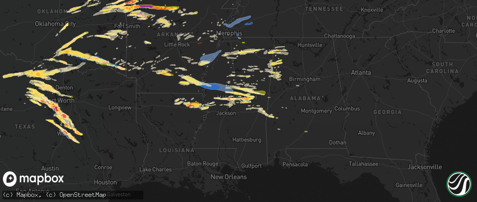
Hail Map in Mississippi on April 28, 2026
The weather event in Mississippi on April 28, 2026 includes Hail, Tornado, and Wind maps. 10 states and 939 cities were impacted and suffered possible damage. The total estimated number of properties impacted is 19,624.
Hail
Tornado
Wind
19,624
Estimated number of impacted properties by a 1.00" hail or larger2,952
Estimated number of impacted properties by a 1.75" hail or larger1,183
Estimated number of impacted properties by a 2.50" hail or largerStorm reports in Mississippi
Mississippi
| Date | Description |
|---|---|
| 04/28/20266:45 PM CDT | Social media pictures of large half dollar sized hail. |
| 04/28/20266:43 PM CDT | Tree on a home on russell topton. |
| 04/28/20266:42 PM CDT | A local report indicates 1.00 inch wind near 4 W Zama |
| 04/28/20266:42 PM CDT | Shed damaged with the roof blown off. |
| 04/28/20266:37 PM CDT | A local report indicates 2.00 inch wind near 3 NNW Pearl River |
| 04/28/20266:21 PM CDT | A local report indicates 2.00 inch wind near 3 W Edinburg |
| 04/28/20266:21 PM CDT | Tree down near 43rd and 40th. |
| 04/28/20266:15 PM CDT | A local report indicates 1.50 inch wind near 1 ENE Sallis |
| 04/28/20266:15 PM CDT | A local report indicates 1.00 inch wind near 3 S Little Rock |
| 04/28/20266:11 PM CDT | A local report indicates 1.75 inch wind near 3 SSW Renfroe |
| 04/28/20265:40 PM CDT | Hwy 17... Hail damage to trees with leaves/debris all across the road. At least ping pong ball if not larger. |
| 04/28/20265:20 PM CDT | A local report indicates 1.50 inch wind near 3 ESE Linwood |
| 04/28/20265:20 PM CDT | Corrects previous hail report from 2 w vaughan. Very large hail around vaughn... Pics of multiple large stone between 2 and 3 inches in diameter. |
| 04/28/20265:04 PM CDT | A local report indicates 1.00 inch wind near 1 SSE Benton |
| 04/28/20264:41 PM CDT | Trees down reported at the intersection of slocum blvd and mccracken rd. Time estimated from radar. |
| 04/28/20264:39 PM CDT | Trees reported down at highway 305 and vaiden road. Time estimated from radar. |
| 04/28/20264:30 PM CDT | Trees reported down at the intersection of nesbit road and horn lake road. Time estimated from radar. |
| 04/28/20263:06 PM CDT | A local report indicates 1.00 inch wind near 11 WNW Kings |
| 04/28/20262:20 PM CDT | Very large hail around vaughn... Pics of multiple large stone between 2 and 3 inches in diameter. |
| 04/28/202611:30 AM CDT | Tree down on house along cr 417. |
| 04/28/202610:08 AM CDT | Quarter-sized hail in the hamilton community. |
| 04/28/20264:42 AM CDT | A local report indicates 1.00 inch wind near 2 NNW New Albany |
| 04/28/20264:15 AM CDT | A local report indicates 1.00 inch wind near 3 SW Abbeville |
| 04/28/20263:04 AM CDT | Photo of quarter size hail near belmont... Ms. |
| 04/28/202612:00 AM CDT | Tree down on a home... Minor damage. |
| 04/27/202611:30 PM CDT | Trees and powerlines down. |
| 04/27/202611:24 PM CDT | Tree down on house on cr 417 near blair... Ms. Time is radar estimated. |
| 04/27/202611:16 PM CDT | Multiple trees down along big john rd. |
| 04/27/202611:03 PM CDT | Tree down in front of house. |
| 04/27/202610:58 PM CDT | Lines down s of cruger. |
| 04/27/202610:45 PM CDT | Lines down. |
| 04/27/202610:40 PM CDT | Numerous trees down along cr 506 in shannon ms. Location matches highest velocities on radar. |
| 04/27/202610:40 PM CDT | Numerous powerlines down in the city of shannon. |
| 04/27/202610:40 PM CDT | Trees down in the four mile community. |
| 04/27/202610:38 PM CDT | *** 1 inj *** tree fell on a home off cr 300. 5 occupants in the home with 1 sustaining a minor head injury. |
| 04/27/202610:34 PM CDT | Trees down around isola. |
| 04/27/202610:31 PM CDT | Multiple trees and power poles snapped in the inverness area. |
| 04/27/202610:20 PM CDT | Tree down across south highland drive. |
| 04/27/202610:09 PM CDT | A section of decorative parapet wall on a hotel was blown down to the ground on ms hwy 182 near s raceway rd. |
| 04/27/202610:07 PM CDT | Scattered trees and power lines down throughout the city of greenville. |
| 04/27/20269:56 PM CDT | Tree down on natchez trace pkwy. Time radar estimated. |
| 04/27/20269:50 PM CDT | Tree down across old hwy 45. Time is radar estimated. |
| 04/27/20269:49 PM CDT | A police vehicle was rolled over and off interstate 22 near exit 18 due to very strong straight-line winds. No injuries reported. Time is radar estimated. |
| 04/27/20269:37 PM CDT | Tree down at the intersection of farley and addison. |
| 04/27/20269:09 PM CDT | Tree down on greenbrook pkwy in southaven. Time is radar estimated. |
| 04/27/20268:16 PM CDT | A local report indicates 1.00 inch wind near 3 S Ellison Ridge |
| 04/27/20268:10 PM CDT | A local report indicates 1.00 inch wind near 4 N Vernon |
| 04/27/20268:00 PM CDT | A local report indicates 1.00 inch wind near 5 N Noxapater |
| 04/27/20267:43 PM CDT | A local report indicates 1.00 inch wind near 8 SSW Highpoint |
| 04/27/20267:34 PM CDT | A local report indicates 1.00 inch wind near 5 SSW Highpoint |
| 04/27/20267:08 PM CDT | Tin blown off a roof on cr 2808. |
| 04/27/20267:03 PM CDT | Tree down across cr 2240. |
All States Impacted by Hail Map on April 28, 2026
Cities Impacted by Hail Map on April 28, 2026
- Seymour, TX
- Prairie, MS
- Vardaman, MS
- Houston, MS
- Aberdeen, MS
- Munday, TX
- Holliday, TX
- Pittsboro, MS
- Calhoun City, MS
- Big Creek, MS
- Derma, MS
- Scotland, TX
- Wichita Falls, TX
- Henrietta, TX
- Windthorst, TX
- Bellevue, TX
- Ringgold, TX
- Bowie, TX
- Woodland, MS
- Nocona, TX
- Montague, TX
- Healdton, OK
- Duck Hill, MS
- Saint Jo, TX
- Muenster, TX
- Leon, OK
- Burneyville, OK
- Sulphur, OK
- Davis, OK
- Eupora, MS
- Stewart, MS
- Walthall, MS
- Gainesville, TX
- Grenada, MS
- Holcomb, MS
- Proctor, OK
- Purcell, OK
- Washington, OK
- Carrollton, MS
- McCarley, MS
- Springer, OK
- Graham, OK
- Ratliff City, OK
- Hamilton, MS
- Wynnewood, OK
- Okolona, MS
- Colcord, OK
- Rose, OK
- Kansas, OK
- Jay, OK
- Watts, OK
- Siloam Springs, AR
- Norman, OK
- Mathiston, MS
- Westville, OK
- Roff, OK
- Thackerville, OK
- Whitesboro, TX
- Marietta, OK
- Mcloud, OK
- Newalla, OK
- Shawnee, OK
- Tecumseh, OK
- Columbus, MS
- Tahlequah, OK
- Hulbert, OK
- Gentry, AR
- Gordonville, TX
- Lebanon, OK
- Kingston, OK
- Vaiden, MS
- Kilmichael, MS
- Starkville, MS
- Oaks, OK
- Mantee, MS
- Gattman, MS
- Greenwood Springs, MS
- Caledonia, MS
- Springdale, AR
- Meeker, OK
- Bentonville, AR
- Sulligent, AL
- Noble, OK
- Canehill, AR
- Lincoln, AR
- Vernon, AL
- Pottsboro, TX
- Fayetteville, AR
- Mead, OK
- Lowell, AR
- Weir, MS
- McCool, MS
- Cave Springs, AR
- Rogers, AR
- Ackerman, MS
- Fayette, AL
- Kennedy, AL
- Millport, AL
- Prairie Grove, AR
- Durant, OK
- Cartwright, OK
- Calera, OK
- Pea Ridge, AR
- Centerton, AR
- Pineville, MO
- Noel, MO
- Decatur, AR
- Rocky Comfort, MO
- Cassville, MO
- Powell, MO
- Washburn, MO
- Exeter, MO
- Elkins, AR
- Gravette, AR
- Hamilton, AL
- Beaverton, AL
- Detroit, AL
- Garfield, AR
- Seligman, MO
- Bella Vista, AR
- Farmington, AR
- West Fork, AR
- Louisville, MS
- Caddo, OK
- Sturgis, MS
- Alexander City, AL
- Amory, MS
- Smithville, MS
- French Camp, MS
- Wesley, AR
- Huntsville, AR
- Hindsville, AR
- Purdy, MO
- Aurora, MO
- Crane, MO
- Wheaton, MO
- Monett, MO
- Butterfield, MO
- Verona, MO
- Bokchito, OK
- Guin, AL
- Billings, MO
- Marionville, MO
- Brilliant, AL
- Eagle Rock, MO
- Smithville, OK
- Honobia, OK
- Haleyville, AL
- Galena, MO
- Clever, MO
- Republic, MO
- Brookline, MO
- Springfield, MO
- Bois D Arc, MO
- Kingston, AR
- Coffeyville, KS
- Edna, KS
- McCalla, AL
- Jerico Springs, MO
- Oswego, KS
- Chetopa, KS
- Stockton, MO
- El Dorado Springs, MO
- Bartlett, KS
- Willard, MO
- Compton, AR
- Berryville, AR
- Ponca, AR
- Green Forest, AR
- Rogersville, MO
- Pleasant Hope, MO
- Strafford, MO
- Fair Grove, MO
- Brighton, MO
- Noxapater, MS
- Philadelphia, MS
- Wagoner, OK
- Liberal, MO
- Montrose, MO
- Urich, MO
- Columbus, KS
- Nixa, MO
- Pawnee, OK
- Hominy, OK
- Fairfax, OK
- Lamar, MO
- Sheldon, MO
- West Point, MS
- Adair, OK
- Marshfield, MO
- Buffalo, MO
- Elkland, MO
- Long Lane, MO
- Conway, MO
- Jasper, AR
- Alpena, AR
- Phillipsburg, MO
- Marble Falls, AR
- Vendor, AR
- Hasty, AR
- Harrison, AR
- Bartlesville, OK
- Dewey, OK
- Delaware, OK
- Louisburg, MO
- Hermitage, MO
- Urbana, MO
- Mansfield, MO
- Norwood, MO
- Macomb, MO
- Windyville, MO
- Lebanon, MO
- Wann, OK
- Lenapah, OK
- Tunas, MO
- Eldridge, MO
- Barnsdall, OK
- Pawhuska, OK
- Ochelata, OK
- Clinton, MO
- Calhoun, MO
- Leeton, MO
- Chilhowee, MO
- S Coffeyville, OK
- Afton, OK
- Wyandotte, OK
- Grove, OK
- Fairland, OK
- Mountain Grove, MO
- Everton, AR
- Western Grove, AR
- Saint Joe, AR
- Pindall, AR
- Big Cabin, OK
- Mena, AR
- Wynona, OK
- Spavinaw, OK
- Farmerville, LA
- Downsville, LA
- Little Rock, MS
- Grovespring, MO
- Ozark, MO
- Niangua, MO
- Broken Bow, OK
- Ethelsville, AL
- Nashville, AR
- Mineral Springs, AR
- Horatio, AR
- Lockesburg, AR
- Polk, MO
- Pittsburg, MO
- Weir, KS
- Scammon, KS
- Bolivar, MO
- Half Way, MO
- Webb City, MO
- Alba, MO
- Asbury, MO
- Jasper, MO
- Carl Junction, MO
- Pittsburg, KS
- Galena, KS
- Oronogo, MO
- Purcell, MO
- Muldrow, OK
- Duenweg, MO
- Diamond, MO
- Joplin, MO
- Carthage, MO
- Humansville, MO
- Fort Gibson, OK
- Vinita, OK
- Stoutland, MO
- Montreal, MO
- Decatur, MS
- Scranton, AR
- Ava, MO
- Foreman, AR
- Winthrop, AR
- Steens, MS
- Eucha, OK
- Sallisaw, OK
- Emelle, AL
- Drury, MO
- Squires, MO
- Arkadelphia, AR
- Bailey, MS
- Meridian, MS
- Murfreesboro, AR
- New Blaine, AR
- Sulphur Springs, AR
- Anderson, MO
- Lamar, AR
- Carthage, MS
- Walnut Grove, MS
- Reeds, MO
- Marion, LA
- Chunky, MS
- Collinsville, MS
- Fair Play, MO
- Conehatta, MS
- Union, MS
- Copan, OK
- Dierks, AR
- Vanzant, MO
- Richland, MO
- Gilbert, AR
- Marshall, AR
- Twin Oaks, OK
- Delight, AR
- Okolona, AR
- Liberty, KS
- Harriet, AR
- Tiff City, MO
- South West City, MO
- Goodman, MO
- Frontenac, KS
- Cherokee, KS
- West Monroe, LA
- Stotts City, MO
- Wentworth, MO
- Sarcoxie, MO
- Sterlington, LA
- Malvern, AR
- Arma, KS
- Miller, MO
- London, AR
- Dover, AR
- Everton, MO
- West Mineral, KS
- McCune, KS
- Monroe, LA
- La Russell, MO
- Ash Grove, MO
- Halltown, MO
- Marion, MS
- Parsons, KS
- Dennis, KS
- Mound Valley, KS
- Welch, OK
- Mount Vernon, MO
- Bismarck, AR
- Walnut Grove, MO
- Collinston, LA
- Bastrop, LA
- Altamont, KS
- Pierce City, MO
- Donaldson, AR
- Valley Springs, AR
- Freistatt, MO
- Iberia, MO
- Saint Elizabeth, MO
- Avilla, MO
- Agra, OK
- Ripley, OK
- Poyen, AR
- Flippin, AR
- Big Flat, AR
- Fifty Six, AR
- Saint Paul, KS
- Mindenmines, MO
- Bronaugh, MO
- Mulberry, KS
- Pauls Valley, OK
- Nevada, MO
- Girard, KS
- Timbo, AR
- Mountain View, AR
- Stark City, MO
- Stella, MO
- Ward, AR
- Yale, OK
- Jennings, OK
- Drumright, OK
- Cushing, OK
- Mannford, OK
- Tryon, OK
- Beebe, AR
- Rayville, LA
- Sparta, MO
- Highlandville, MO
- Petrolia, TX
- Oak Ridge, LA
- Mer Rouge, LA
- Austin, AR
- Hennepin, OK
- Jerusalem, AR
- Atkins, AR
- Hattieville, AR
- Elmore City, OK
- Leslie, AR
- Onia, AR
- Waurika, OK
- Sand Springs, OK
- Lincoln, MO
- Stover, MO
- Fairview, MO
- Neosho, MO
- Warsaw, MO
- Edwards, MO
- Meta, MO
- Vilonia, AR
- Conway, AR
- Jacksonville, AR
- El Paso, AR
- Duncan, OK
- Pioneer, LA
- Delhi, LA
- Lake Providence, LA
- Sondheimer, LA
- Epps, LA
- Gravois Mills, MO
- Rocky Mount, MO
- Ringling, OK
- Moundville, MO
- Carterville, MO
- Versailles, MO
- Shell Knob, MO
- Stratford, OK
- Stroud, OK
- Des Arc, AR
- Archer City, TX
- Tulsa, OK
- Skiatook, OK
- Forsyth, MO
- Arcadia, KS
- McRae, AR
- Searcy, AR
- Garner, AR
- Seymour, MO
- Milo, MO
- Sperry, OK
- Lonoke, AR
- Carlisle, AR
- Melbourne, AR
- Golden City, MO
- Collinsville, OK
- Gallion, AL
- Ada, OK
- Barnett, MO
- Pleasant Grove, AR
- Fordland, MO
- Griffithville, AR
- Cape Fair, MO
- Ryan, OK
- Hartville, MO
- Depew, OK
- Bristow, OK
- Tallulah, LA
- Oak Grove, LA
- Batesville, AR
- Marcella, AR
- Guion, AR
- Loco, OK
- Faunsdale, AL
- Cotton Plant, AR
- Eldon, MO
- Mill Creek, OK
- Konawa, OK
- Sulphur Rock, AR
- Cave City, AR
- Charlotte, AR
- Chelsea, OK
- Talala, OK
- Oologah, OK
- Owasso, OK
- Claremore, OK
- Fountain Hill, AR
- Sapulpa, OK
- Transylvania, LA
- Heber Springs, AR
- Tishomingo, OK
- Stonewall, OK
- Wilson, OK
- Sasakwa, OK
- Holdenville, OK
- Harrisburg, AR
- Jacksboro, TX
- Catoosa, OK
- Chadwick, MO
- Wynne, AR
- McCrory, AR
- Olney, TX
- Vicksburg, MS
- Dora, MO
- Gould, AR
- Grady, AR
- Jachin, AL
- Butler, AL
- Lisman, AL
- Wewoka, OK
- Lone Grove, OK
- Milburn, OK
- Wapanucka, OK
- Marked Tree, AR
- Overbrook, OK
- Ardmore, OK
- Hackleburg, AL
- Valley Park, MS
- Inola, OK
- Cherry Valley, AR
- Taneyville, MO
- Loving, TX
- Coleman, OK
- Tupelo, OK
- Wetumka, OK
- Heth, AR
- Willow Springs, MO
- West Plains, MO
- Pomona, MO
- De Witt, AR
- Tichnor, AR
- Ethel, AR
- Saint Charles, AR
- Lamar, OK
- Dustin, OK
- Stuttgart, AR
- Sunset, TX
- Bear Creek, AL
- Greenwood, MS
- Atoka, OK
- Graham, TX
- Newcastle, TX
- Eudora, AR
- Coalgate, OK
- Pottersville, MO
- Cabool, MO
- Peace Valley, MO
- Chouteau, OK
- Mountain View, MO
- Locust Grove, OK
- Bryson, TX
- Forestburg, TX
- Muskogee, OK
- Tyronza, AR
- Calvin, OK
- Caney, OK
- Kenefic, OK
- Cord, AR
- Newark, AR
- Elaine, AR
- Helena, AR
- Holly Grove, AR
- Mellwood, AR
- Lexa, AR
- Crumrod, AR
- Alligator, MS
- Snow Lake, AR
- Coahoma, MS
- Clarksdale, MS
- Friars Point, MS
- Duncan, MS
- Summersville, MO
- Gilmore, AR
- Bassett, AR
- Frenchmans Bayou, AR
- Joiner, AR
- Turrell, AR
- Lane, OK
- Birch Tree, MO
- Mcalester, OK
- Porter, OK
- Stuart, OK
- Coweta, OK
- Rolling Fork, MS
- Madill, OK
- Chico, TX
- Bridgeport, TX
- Dyess, AR
- Peggs, OK
- Kinta, OK
- Sweet Water, AL
- Drummonds, TN
- Steele, MO
- Dundee, MS
- Sledge, MS
- Tunica, MS
- Perrin, TX
- Alton, MO
- Winona, MO
- Fremont, MO
- Doniphan, MO
- Van Buren, MO
- Collierville, TN
- Antlers, OK
- Eads, TN
- Paradise, TX
- Decatur, TX
- Graford, TX
- Burlison, TN
- Millington, TN
- Brighton, TN
- Covington, TN
- Munford, TN
- Atoka, TN
- Gatewood, MO
- Alvord, TX
- Indianola, OK
- Byhalia, MS
- Red Banks, MS
- Keota, OK
- Mccurtain, OK
- Stigler, OK
- Breckenridge, TX
- South Bend, TX
- Yazoo City, MS
- Holly Bluff, MS
- Jackson, AL
- Gans, OK
- Quinton, OK
- Atwood, OK
- Haskell, OK
- Okmulgee, OK
- Redbird, OK
- Beggs, OK
- Holly Springs, MS
- Grandin, MO
- Summers, AR
- Henning, TN
- Soper, OK
- Hugo, OK
- Rhome, TX
- Boyd, TX
- Mineral Wells, TX
- Weatherford, TX
- Whitt, TX
- Bokoshe, OK
- Rattan, OK
- Spiro, OK
- Grove Hill, AL
- Wilburton, OK
- Couch, MO
- Fairdealing, MO
- Poplar Bluff, MO
- Oxly, MO
- Success, AR
- Maynard, AR
- Naylor, MO
- Neelyville, MO
- Harviell, MO
- Corning, AR
- Brownsville, TN
- Ripley, TN
- Benton, MS
- Red Oak, OK
- Poteau, OK
- Stilwell, OK
- Shady Point, OK
- Vaughan, MS
- Macks Creek, MO
- Clinton, KY
- Palo Pinto, TX
- Cameron, OK
- Haslet, TX
- Wister, OK
- Ellsinore, MO
- Spencerville, OK
- Moyers, OK
- Sawyer, OK
- Springtown, TX
- Fort Towson, OK
- Newark, TX
- Justin, TX
- Boaz, KY
- Hickory, KY
- Strawn, TX
- Hackett, AR
- Pocola, OK
- Boswell, OK
- Natural Dam, AR
- Chester, AR
- Winslow, AR
- East Prairie, MO
- Charleston, MO
- Pickens, MS
- Camdenton, MO
- Millsap, TX
- Qulin, MO
- Pollard, AR
- Piggott, AR
- Valliant, OK
- Garvin, OK
- Campbell, MO
- Saint Francis, AR
- Greenway, AR
- Southlake, TX
- Roanoke, TX
- Keller, TX
- Idabel, OK
- Wright City, OK
- Canton, MS
- Camden, MS
- Mountainburg, AR
- Symsonia, KY
- Fort Worth, TX
- Morrow, AR
- Welling, OK
- Grapevine, TX
- Colleyville, TX
- North Richland Hills, TX
- Lexington, MS
- Combs, AR
- Paducah, KY
- Howe, OK
- Fort Smith, AR
- Aledo, TX
- Ozark, AR
- Saint Paul, AR
- Kosciusko, MS
- Holcomb, MO
- Clarkton, MO
- Gideon, MO
- Gordon, TX
- Rector, AR
- Caddo, TX
- Sallis, MS
- Heavener, OK
- Dryden, TX
- Pettigrew, AR
- Witter, AR
- Durant, MS
- Goodman, MS
- Irving, TX
- Dallas, TX
- Gibson, MO
- Wardell, MO
- Mayfield, KY
- Malden, MO
- Broseley, MO
- Haworth, OK
- Cresson, TX
- Granbury, TX
- Santo, TX
- Bells, TN
- Alamo, TN
- Stanton, TN
- Whiteville, TN
- Denmark, TN
- Mercer, TN
- Oark, AR
- Eagletown, OK
- Hector, AR
- Russellville, AR
- Deer, AR
- Lena, MS
- Bentonia, MS
- Godley, TX
- Crowley, TX
- Burleson, TX
- Joshua, TX
- Clarksville, AR
- Cruger, MS
- Comstock, TX
- Memphis, TN
- De Queen, AR
- Keene, TX
- Cleburne, TX
- West, MS
- Coila, MS
- Lipan, TX
- Ethel, MS
- Toomsuba, MS
- Hagarville, AR
- Ozone, AR
- Earle, AR
- Pelsor, AR
- Alvarado, TX
- Witts Springs, AR
- Plainview, AR
- Sherwood, AR
- Little Rock Air Force Base, AR
- Gravelly, AR
- Harvey, AR
- Grandview, TX
- Rio Vista, TX
- Covington, TX
- Itasca, TX
- Drasco, AR
- Ozan, AR
- Clinton, AR
- Scotland, AR
- Cleveland, AR
- Center Ridge, AR
- Cabot, AR
- Bluffton, AR
- Tilly, AR
- Bee Branch, AR
- Quitman, MS
- Gurdon, AR
- Prescott, AR
- Milford, TX
- Damascus, AR
- Hillsboro, TX
- Blum, TX
- Georgiana, AL
- Wilburn, AR
- Tumbling Shoals, AR
- Chidester, AR
- Macon, MS
- Shuqualak, MS
- Whitney, TX
- Abbott, TX
- Mertens, TX
- Bynum, TX
- Brinkley, AR
- Clarendon, AR
- Hermitage, AR
- Wilmar, AR
- Bearden, AR
- Camden, AR
- Penelope, TX
- Malone, TX
- Sparkman, AR
- Iredell, TX
- Bluff City, AR
- Forrest City, AR
- Italy, TX
- Walnut Springs, TX
- Colt, AR
- Hamburg, AR
- Monticello, AR
- Frost, TX
- Mount Calm, TX
- West, TX
- Meridian, TX
- Morgan, TX
- Thornton, AR
- Hampton, AR
- Warren, AR
- Banks, AR
- Winona, MS
- Widener, AR
- Hubbard, TX
- Fordyce, AR
- Sidon, MS
- Elizabethtown, KY
- Dawson, TX
- Coolidge, TX
- Axtell, TX
- Clifton, TX
- Batesville, MS
- Sardis, MS
- Montrose, AR
- Dermott, AR
- Madison, AR
- Marianna, AR
- Palestine, AR
- Prairie Hill, TX
- Groesbeck, TX
- Aquilla, TX
- Valley Mills, TX
- Lake Village, AR
- Mexia, TX
- Hughes, AR
- China Spring, TX
- Waco, TX
- Portland, AR
- Elm Mott, TX
- Leland, MS
- Greenville, MS
- Riesel, TX
- Mart, TX
- Houlka, MS
- Carthage, AR
- Marlin, TX
- Sherrill, AR
- White Hall, AR
- Kosse, TX
- Thornton, TX
- Kingsland, AR
- Rison, AR
- Tremont, MS
- Altheimer, AR
- Pine Bluff, AR
- Indianola, MS
- Inverness, MS
- Hollandale, MS
- Isola, MS
- Belzoni, MS
- Itta Bena, MS
- Tchula, MS
- Star City, AR
- Reagan, TX
- Bremond, TX
- Franklin, TX
- Gillett, AR
- Reform, AL
- Gordo, AL
- Enid, MS
- Courtland, MS
- Oakland, MS
- Pope, MS
- Scobey, MS
- Gunnison, MS
- Marietta, MS
- Booneville, MS
- Baldwyn, MS
- Golden, MS
- Fulton, MS
- New Site, MS
- Dennis, MS
- Belmont, MS
- Como, MS
- Marks, MS
- Water Valley, MS
- Red Bay, AL
- Hodges, AL
- Oxford, MS
- Abbeville, MS
- Crenshaw, MS
- Russellville, AL
- New Edinburg, AR
- Vina, AL
- Spruce Pine, AL
- Phil Campbell, AL
- Taylor, MS
- Mount Hope, AL
- Mayersville, MS
- Flora, MS
- Satartia, MS
- Etta, MS
- New Albany, MS
- Myrtle, MS
- Hickory Flat, MS
- Thaxton, MS
- Potts Camp, MS
- Mantachie, MS
- Blue Mountain, MS
- Redwood, MS
- Dumas, MS
- Madison, MS
- Blue Springs, MS
- Guntown, MS
- Senatobia, MS
- Coldwater, MS
- Tuscumbia, AL
- Cherokee, AL
- Falcon, MO
- Linn Creek, MO


