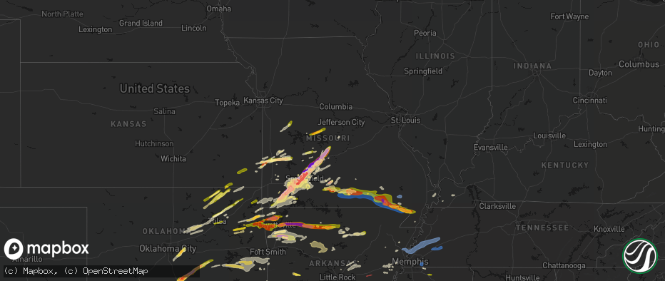
Hail Map in Missouri on April 28, 2026
The weather event in Missouri on April 28, 2026 includes Hail, Tornado, and Wind maps. 10 states and 939 cities were impacted and suffered possible damage. The total estimated number of properties impacted is 179,926.
Hail
Tornado
Wind
179,926
Estimated number of impacted properties by a 1.00" hail or larger98,506
Estimated number of impacted properties by a 1.75" hail or larger122,963
Estimated number of impacted properties by a 2.50" hail or largerStorm reports in Missouri
Missouri
| Date | Description |
|---|---|
| 04/28/20265:38 PM CDT | Ping pong to golf ball size hail in holocomb. |
| 04/28/20265:36 PM CDT | Tree over the road south of campbell. |
| 04/28/20265:15 PM CDT | Asos station kpof poplar bluff mo. |
| 04/28/20265:05 PM CDT | A local report indicates 70 MPH wind near Neelyville |
| 04/28/20265:05 PM CDT | Outbuilding blown into a house... Trees and power lines down. Power poles snapped on highway 142 just south of naylor. |
| 04/28/20265:00 PM CDT | Tractor trailer blown over on us 67 one mile north of the arkansas state line. |
| 04/28/20264:55 PM CDT | Large trees down in oxly. |
| 04/28/20264:49 PM CDT | Power pole down on highway h just south of naylor. Time estimated. |
| 04/28/20264:46 PM CDT | Damage to a barn and pickup truck on highway h between county roads h-5 and h-3. Time estimated. |
| 04/28/20264:45 PM CDT | A local report indicates 2.00 inch wind near Doniphan |
| 04/28/20264:45 PM CDT | A local report indicates 1.00 inch wind near Doniphan |
| 04/28/20264:45 PM CDT | Several trees down in oxly. Time estimated. |
| 04/28/20264:43 PM CDT | A local report indicates 1.75 inch wind near 2 N Doniphan |
| 04/28/20264:43 PM CDT | Large trees uprooted and large limbs down on county road 142e30 south of oxly. Time estimated. |
| 04/28/20264:43 PM CDT | A local report indicates 1.00 inch wind near 1 N Doniphan |
| 04/28/20264:41 PM CDT | Large tree snapped. |
| 04/28/20264:41 PM CDT | 60 mph wind gust and pea sized hail. |
| 04/28/20264:38 PM CDT | Several hailstones photographed around 1-1.5in... With one elongated hailstone up to 2.5in. |
| 04/28/20264:38 PM CDT | Roof and siding damage to a home on county road 142-e8. Time estimated from radar. |
| 04/28/20264:37 PM CDT | Reported on highway 21 on the carter/ripley county line. |
| 04/28/20263:39 PM CDT | Quarter size hail 9 miles southwest of mtn view mo... Howell county... Spotter report. |
| 04/28/20263:38 PM CDT | Large trees down. |
| 04/28/20263:38 PM CDT | Several trees down 17 highway north of west plains... Howell co... North of white church. |
| 04/28/20263:37 PM CDT | A local report indicates 1.75 inch wind near 4 SSE Pomona |
| 04/28/20263:35 PM CDT | Tree fell on house. Large branches off of trees. |
| 04/28/20263:35 PM CDT | 6-8 inch tree limbs down in west plains at cc and christopher drive. |
| 04/28/20263:34 PM CDT | Tree down across the road on co rd 4870... Howell county. |
| 04/28/20263:34 PM CDT | A local report indicates 1.75 inch wind near Pomona |
| 04/28/20263:33 PM CDT | A local report indicates 60 MPH wind near Pomona |
| 04/28/20263:30 PM CDT | Large tree down. |
| 04/28/20263:00 PM CDT | A report of tree down 95 hwy just north of gentryville in douglas county. Road blocked. |
| 04/28/20262:59 PM CDT | Tree down on the e side of co rd zz 137 off e 76 hwy. |
| 04/28/20262:58 PM CDT | Douglas county has had a report of a tree on c hwy north of skyline school... About 4 miles. |
| 04/28/20262:29 PM CDT | A local report indicates 1.50 inch wind near 3 N Gravois Mills |
| 04/28/20262:05 PM CDT | Report from mping half dollar 1.25 inches. |
| 04/28/20261:55 PM CDT | Report from mping quarter 1.00 inch. |
| 04/28/20261:54 PM CDT | Report from mping quarter 1.00 inch. |
| 04/28/20261:48 PM CDT | Amateur radio reports quarter size hail in nixa. |
| 04/28/20261:47 PM CDT | Report from mping quarter 1.00 inch. |
| 04/28/20261:47 PM CDT | A local report indicates 1.00 inch wind near 3 NE Boaz |
| 04/28/20261:46 PM CDT | Report from mping quarter 1.00 inch. |
| 04/28/20261:37 PM CDT | Off duty officer reports golf ball sized hail in liberal. |
| 04/28/20261:29 PM CDT | Report from mping quarter size hail in republic. |
| 04/28/20261:29 PM CDT | A local report indicates 1.00 inch wind near Marionville |
| 04/28/20261:18 PM CDT | Tree down over the roadway. |
| 04/28/20261:17 PM CDT | A local report indicates 1.00 inch wind near 1 SW Springfield |
| 04/28/20261:05 PM CDT | Report from mping quarter 1.00 inch. |
| 04/28/202612:52 PM CDT | A local report indicates 1.75 inch wind near Montreal |
| 04/28/202612:45 PM CDT | A local report indicates 1.00 inch wind near Stoutland |
| 04/28/202612:38 PM CDT | Vehicles damaged along with sky lights broken. Up to 2 inch hail estimated. |
| 04/28/202612:37 PM CDT | A local report indicates 2.00 inch wind near 4 N Springfield |
| 04/28/202612:36 PM CDT | A local report indicates 3.00 inch wind near 4 N Bennett Springs |
| 04/28/202612:35 PM CDT | Up to ping ball size hail damaged 15 city vehicles including breaking wind shields. |
| 04/28/202612:33 PM CDT | A local report indicates 1.75 inch wind near Norwood |
| 04/28/202612:30 PM CDT | Emergency manager reported ping pong size hail with photos at sand spring resort. |
| 04/28/202612:28 PM CDT | Usfs reports 2 inch hail 1.8 mi nnw macomb. |
| 04/28/202612:22 PM CDT | Quarter-sized hail observed in leeton. |
| 04/28/202612:18 PM CDT | Report from mping tennis ball 2.50 in. |
| 04/28/202612:15 PM CDT | A local report indicates 1.50 inch wind near 2 SSE Charity |
| 04/28/202612:11 PM CDT | Several reports of 1.75 to 2 inch hail in northwest webster county. |
| 04/28/202612:11 PM CDT | Quarter sized hail reports from fire relayed from 911 call center. |
| 04/28/202612:10 PM CDT | A local report indicates 1.00 inch wind near 3 E Elkland |
| 04/28/202612:10 PM CDT | Hail occurred on long horn road. |
| 04/28/202612:10 PM CDT | Report from mping half dollar 1.25 in. |
| 04/28/202612:10 PM CDT | Report from mping hen egg 2.00 in. |
| 04/28/202612:09 PM CDT | A local report indicates 1.75 inch wind near 2 WSW Olive |
| 04/28/202612:09 PM CDT | A local report indicates 1.00 inch wind near 4 W Olive |
| 04/28/202612:06 PM CDT | Report from mping 3.25 in hail. |
| 04/28/202612:04 PM CDT | 1.5 to 2.25 inch fell. |
| 04/28/202612:04 PM CDT | At least golf ball sized hail in fair grove. Numerous windows broken at the high school. |
| 04/28/202612:01 PM CDT | Report from mping golf ball 1.75 inches. |
| 04/28/202612:00 PM CDT | A local report indicates 2.50 inch wind near 2 NW Springfield |
| 04/28/202612:00 PM CDT | Report from mping hen egg 2.00 in. |
| 04/28/202612:00 PM CDT | A local report indicates 1.50 inch wind near 3 SW Bassville |
| 04/28/202611:58 AM CDT | Report from mping: quarter |
| 04/28/202611:55 AM CDT | Report from mping golf ball 1.75 inches. |
| 04/28/202611:54 AM CDT | Report from mping golf ball 1.75 inches. |
| 04/28/202611:54 AM CDT | A local report indicates 2.75 inch wind near 4 NNE Springfield |
| 04/28/202611:51 AM CDT | A local report indicates 2.75 inch wind near 5 SSW Glidewell |
| 04/28/202611:51 AM CDT | Report from mping golf ball 1.75 inches. |
| 04/28/202611:50 AM CDT | Powerlines down on atlantic st. |
| 04/28/202611:50 AM CDT | Delayed report. |
| 04/28/202611:50 AM CDT | Significant hail damage at the dickerson park zoo. One animal was killed and another injured. |
| 04/28/202611:49 AM CDT | Report from mping tennis ball 2.50 in. |
| 04/28/202611:49 AM CDT | Report from mping golf ball 1.75 in. |
| 04/28/202611:49 AM CDT | Report from mping hen egg 2.00 in. |
| 04/28/202611:49 AM CDT | Hail at otc. |
| 04/28/202611:47 AM CDT | Report from mping quarter 1.00 inch. |
| 04/28/202611:47 AM CDT | Report from mping hail larger than hen egg. |
| 04/28/202611:46 AM CDT | Report from mping tennis ball 2.50 in. |
| 04/28/202611:45 AM CDT | A local report indicates 2.50 inch wind near 4 WNW Springfield |
| 04/28/202611:45 AM CDT | Broken car windows... Dents... Damaged tree limbs. Damage to siding. |
| 04/28/202611:45 AM CDT | Several reports of powerlines down in northwest springfield. |
| 04/28/202611:45 AM CDT | Several reports of powerlines down in this area. |
| 04/28/202611:45 AM CDT | Power line down on homewood ave. |
| 04/28/202611:45 AM CDT | Lots of baseball sized hail for around 2-3 minutes at the nws springfield office. |
| 04/28/202611:45 AM CDT | Report from mping baseball 2.75 in. |
| 04/28/202611:45 AM CDT | Corrects previous hail report from 5 sse willard. 30 minutes after the hail fell... A 4 inch hailstone was retrieved from the melting remnants in the parking lot. Lots |
| 04/28/202611:45 AM CDT | Report from mping golf ball 1.75 inches. |
| 04/28/202611:45 AM CDT | Minor tree and roof damage from the hail. |
| 04/28/202611:44 AM CDT | Report from mping tea cup 3.00 in. |
| 04/28/202611:43 AM CDT | Delayed report of 4.75 inch hail in western springfield from the storm tuesday morning. Time estimated by radar. |
| 04/28/202611:43 AM CDT | Report from mping bigger than hen eggs 2.25in. |
| 04/28/202611:40 AM CDT | A local report indicates 1.75 inch wind near 3 WNW Nixa |
| 04/28/202611:40 AM CDT | Largest hail stone measured by off duty employee was 3.25 inches. |
| 04/28/202611:40 AM CDT | Spotter reports vehicle and house damaged. Roof damage and all guttering torn off by tennis ball size hail. |
| 04/28/202611:38 AM CDT | Report from mping hen egg 2.00 in. |
| 04/28/202611:35 AM CDT | A local report indicates 2.75 inch wind near Billings |
| 04/28/202611:35 AM CDT | A local report indicates 1.75 inch wind near Billings |
| 04/28/202611:35 AM CDT | A local report indicates 2.00 inch wind near 2 E Billings |
| 04/28/202611:28 AM CDT | A local report indicates 1.75 inch wind near Marionville |
| 04/28/202611:24 AM CDT | Windshields... Car dents... Damage to roof. |
| 04/28/202611:24 AM CDT | Hail between a baseball and a softball. |
| 04/28/202611:24 AM CDT | Powerline down. |
| 04/28/202611:22 AM CDT | Numerous reports of 2-3 inch size hail in aurora. |
| 04/28/202611:11 AM CDT | A local report indicates 3.00 inch wind near 3 WSW Pleasant Ridge |
| 04/28/202611:07 AM CDT | Numerous reports of 2in hail in purdy. |
| 04/28/202611:03 AM CDT | Report from mping - quarter |
| 04/28/202610:58 AM CDT | Between wheaton and purdy. |
| 04/28/202610:52 AM CDT | A local report indicates 2.00 inch wind near Rocky Comfort |
| 04/28/202610:52 AM CDT | A local report indicates 2.00 inch wind near 2 WNW Ridgley |
| 04/28/202610:52 AM CDT | A local report indicates 1.00 inch wind near Exeter |
| 04/28/202610:32 AM CDT | A local report indicates 1.00 inch wind near 5 SE Pineville |
All States Impacted by Hail Map on April 28, 2026
Cities Impacted by Hail Map on April 28, 2026
- Seymour, TX
- Prairie, MS
- Vardaman, MS
- Houston, MS
- Aberdeen, MS
- Munday, TX
- Holliday, TX
- Pittsboro, MS
- Calhoun City, MS
- Big Creek, MS
- Derma, MS
- Scotland, TX
- Wichita Falls, TX
- Henrietta, TX
- Windthorst, TX
- Bellevue, TX
- Ringgold, TX
- Bowie, TX
- Woodland, MS
- Nocona, TX
- Montague, TX
- Healdton, OK
- Duck Hill, MS
- Saint Jo, TX
- Muenster, TX
- Leon, OK
- Burneyville, OK
- Sulphur, OK
- Davis, OK
- Eupora, MS
- Stewart, MS
- Walthall, MS
- Gainesville, TX
- Grenada, MS
- Holcomb, MS
- Proctor, OK
- Purcell, OK
- Washington, OK
- Carrollton, MS
- McCarley, MS
- Springer, OK
- Graham, OK
- Ratliff City, OK
- Hamilton, MS
- Wynnewood, OK
- Okolona, MS
- Colcord, OK
- Rose, OK
- Kansas, OK
- Jay, OK
- Watts, OK
- Siloam Springs, AR
- Norman, OK
- Mathiston, MS
- Westville, OK
- Roff, OK
- Thackerville, OK
- Whitesboro, TX
- Marietta, OK
- Mcloud, OK
- Newalla, OK
- Shawnee, OK
- Tecumseh, OK
- Columbus, MS
- Tahlequah, OK
- Hulbert, OK
- Gentry, AR
- Gordonville, TX
- Lebanon, OK
- Kingston, OK
- Vaiden, MS
- Kilmichael, MS
- Starkville, MS
- Oaks, OK
- Mantee, MS
- Gattman, MS
- Greenwood Springs, MS
- Caledonia, MS
- Springdale, AR
- Meeker, OK
- Bentonville, AR
- Sulligent, AL
- Noble, OK
- Canehill, AR
- Lincoln, AR
- Vernon, AL
- Pottsboro, TX
- Fayetteville, AR
- Mead, OK
- Lowell, AR
- Weir, MS
- McCool, MS
- Cave Springs, AR
- Rogers, AR
- Ackerman, MS
- Fayette, AL
- Kennedy, AL
- Millport, AL
- Prairie Grove, AR
- Durant, OK
- Cartwright, OK
- Calera, OK
- Pea Ridge, AR
- Centerton, AR
- Pineville, MO
- Noel, MO
- Decatur, AR
- Rocky Comfort, MO
- Cassville, MO
- Powell, MO
- Washburn, MO
- Exeter, MO
- Elkins, AR
- Gravette, AR
- Hamilton, AL
- Beaverton, AL
- Detroit, AL
- Garfield, AR
- Seligman, MO
- Bella Vista, AR
- Farmington, AR
- West Fork, AR
- Louisville, MS
- Caddo, OK
- Sturgis, MS
- Alexander City, AL
- Amory, MS
- Smithville, MS
- French Camp, MS
- Wesley, AR
- Huntsville, AR
- Hindsville, AR
- Purdy, MO
- Aurora, MO
- Crane, MO
- Wheaton, MO
- Monett, MO
- Butterfield, MO
- Verona, MO
- Bokchito, OK
- Guin, AL
- Billings, MO
- Marionville, MO
- Brilliant, AL
- Eagle Rock, MO
- Smithville, OK
- Honobia, OK
- Haleyville, AL
- Galena, MO
- Clever, MO
- Republic, MO
- Brookline, MO
- Springfield, MO
- Bois D Arc, MO
- Kingston, AR
- Coffeyville, KS
- Edna, KS
- McCalla, AL
- Jerico Springs, MO
- Oswego, KS
- Chetopa, KS
- Stockton, MO
- El Dorado Springs, MO
- Bartlett, KS
- Willard, MO
- Compton, AR
- Berryville, AR
- Ponca, AR
- Green Forest, AR
- Rogersville, MO
- Pleasant Hope, MO
- Strafford, MO
- Fair Grove, MO
- Brighton, MO
- Noxapater, MS
- Philadelphia, MS
- Wagoner, OK
- Liberal, MO
- Montrose, MO
- Urich, MO
- Columbus, KS
- Nixa, MO
- Pawnee, OK
- Hominy, OK
- Fairfax, OK
- Lamar, MO
- Sheldon, MO
- West Point, MS
- Adair, OK
- Marshfield, MO
- Buffalo, MO
- Elkland, MO
- Long Lane, MO
- Conway, MO
- Jasper, AR
- Alpena, AR
- Phillipsburg, MO
- Marble Falls, AR
- Vendor, AR
- Hasty, AR
- Harrison, AR
- Bartlesville, OK
- Dewey, OK
- Delaware, OK
- Louisburg, MO
- Hermitage, MO
- Urbana, MO
- Mansfield, MO
- Norwood, MO
- Macomb, MO
- Windyville, MO
- Lebanon, MO
- Wann, OK
- Lenapah, OK
- Tunas, MO
- Eldridge, MO
- Barnsdall, OK
- Pawhuska, OK
- Ochelata, OK
- Clinton, MO
- Calhoun, MO
- Leeton, MO
- Chilhowee, MO
- S Coffeyville, OK
- Afton, OK
- Wyandotte, OK
- Grove, OK
- Fairland, OK
- Mountain Grove, MO
- Everton, AR
- Western Grove, AR
- Saint Joe, AR
- Pindall, AR
- Big Cabin, OK
- Mena, AR
- Wynona, OK
- Spavinaw, OK
- Farmerville, LA
- Downsville, LA
- Little Rock, MS
- Grovespring, MO
- Ozark, MO
- Niangua, MO
- Broken Bow, OK
- Ethelsville, AL
- Nashville, AR
- Mineral Springs, AR
- Horatio, AR
- Lockesburg, AR
- Polk, MO
- Pittsburg, MO
- Weir, KS
- Scammon, KS
- Bolivar, MO
- Half Way, MO
- Webb City, MO
- Alba, MO
- Asbury, MO
- Jasper, MO
- Carl Junction, MO
- Pittsburg, KS
- Galena, KS
- Oronogo, MO
- Purcell, MO
- Muldrow, OK
- Duenweg, MO
- Diamond, MO
- Joplin, MO
- Carthage, MO
- Humansville, MO
- Fort Gibson, OK
- Vinita, OK
- Stoutland, MO
- Montreal, MO
- Decatur, MS
- Scranton, AR
- Ava, MO
- Foreman, AR
- Winthrop, AR
- Steens, MS
- Eucha, OK
- Sallisaw, OK
- Emelle, AL
- Drury, MO
- Squires, MO
- Arkadelphia, AR
- Bailey, MS
- Meridian, MS
- Murfreesboro, AR
- New Blaine, AR
- Sulphur Springs, AR
- Anderson, MO
- Lamar, AR
- Carthage, MS
- Walnut Grove, MS
- Reeds, MO
- Marion, LA
- Chunky, MS
- Collinsville, MS
- Fair Play, MO
- Conehatta, MS
- Union, MS
- Copan, OK
- Dierks, AR
- Vanzant, MO
- Richland, MO
- Gilbert, AR
- Marshall, AR
- Twin Oaks, OK
- Delight, AR
- Okolona, AR
- Liberty, KS
- Harriet, AR
- Tiff City, MO
- South West City, MO
- Goodman, MO
- Frontenac, KS
- Cherokee, KS
- West Monroe, LA
- Stotts City, MO
- Wentworth, MO
- Sarcoxie, MO
- Sterlington, LA
- Malvern, AR
- Arma, KS
- Miller, MO
- London, AR
- Dover, AR
- Everton, MO
- West Mineral, KS
- McCune, KS
- Monroe, LA
- La Russell, MO
- Ash Grove, MO
- Halltown, MO
- Marion, MS
- Parsons, KS
- Dennis, KS
- Mound Valley, KS
- Welch, OK
- Mount Vernon, MO
- Bismarck, AR
- Walnut Grove, MO
- Collinston, LA
- Bastrop, LA
- Altamont, KS
- Pierce City, MO
- Donaldson, AR
- Valley Springs, AR
- Freistatt, MO
- Iberia, MO
- Saint Elizabeth, MO
- Avilla, MO
- Agra, OK
- Ripley, OK
- Poyen, AR
- Flippin, AR
- Big Flat, AR
- Fifty Six, AR
- Saint Paul, KS
- Mindenmines, MO
- Bronaugh, MO
- Mulberry, KS
- Pauls Valley, OK
- Nevada, MO
- Girard, KS
- Timbo, AR
- Mountain View, AR
- Stark City, MO
- Stella, MO
- Ward, AR
- Yale, OK
- Jennings, OK
- Drumright, OK
- Cushing, OK
- Mannford, OK
- Tryon, OK
- Beebe, AR
- Rayville, LA
- Sparta, MO
- Highlandville, MO
- Petrolia, TX
- Oak Ridge, LA
- Mer Rouge, LA
- Austin, AR
- Hennepin, OK
- Jerusalem, AR
- Atkins, AR
- Hattieville, AR
- Elmore City, OK
- Leslie, AR
- Onia, AR
- Waurika, OK
- Sand Springs, OK
- Lincoln, MO
- Stover, MO
- Fairview, MO
- Neosho, MO
- Warsaw, MO
- Edwards, MO
- Meta, MO
- Vilonia, AR
- Conway, AR
- Jacksonville, AR
- El Paso, AR
- Duncan, OK
- Pioneer, LA
- Delhi, LA
- Lake Providence, LA
- Sondheimer, LA
- Epps, LA
- Gravois Mills, MO
- Rocky Mount, MO
- Ringling, OK
- Moundville, MO
- Carterville, MO
- Versailles, MO
- Shell Knob, MO
- Stratford, OK
- Stroud, OK
- Des Arc, AR
- Archer City, TX
- Tulsa, OK
- Skiatook, OK
- Forsyth, MO
- Arcadia, KS
- McRae, AR
- Searcy, AR
- Garner, AR
- Seymour, MO
- Milo, MO
- Sperry, OK
- Lonoke, AR
- Carlisle, AR
- Melbourne, AR
- Golden City, MO
- Collinsville, OK
- Gallion, AL
- Ada, OK
- Barnett, MO
- Pleasant Grove, AR
- Fordland, MO
- Griffithville, AR
- Cape Fair, MO
- Ryan, OK
- Hartville, MO
- Depew, OK
- Bristow, OK
- Tallulah, LA
- Oak Grove, LA
- Batesville, AR
- Marcella, AR
- Guion, AR
- Loco, OK
- Faunsdale, AL
- Cotton Plant, AR
- Eldon, MO
- Mill Creek, OK
- Konawa, OK
- Sulphur Rock, AR
- Cave City, AR
- Charlotte, AR
- Chelsea, OK
- Talala, OK
- Oologah, OK
- Owasso, OK
- Claremore, OK
- Fountain Hill, AR
- Sapulpa, OK
- Transylvania, LA
- Heber Springs, AR
- Tishomingo, OK
- Stonewall, OK
- Wilson, OK
- Sasakwa, OK
- Holdenville, OK
- Harrisburg, AR
- Jacksboro, TX
- Catoosa, OK
- Chadwick, MO
- Wynne, AR
- McCrory, AR
- Olney, TX
- Vicksburg, MS
- Dora, MO
- Gould, AR
- Grady, AR
- Jachin, AL
- Butler, AL
- Lisman, AL
- Wewoka, OK
- Lone Grove, OK
- Milburn, OK
- Wapanucka, OK
- Marked Tree, AR
- Overbrook, OK
- Ardmore, OK
- Hackleburg, AL
- Valley Park, MS
- Inola, OK
- Cherry Valley, AR
- Taneyville, MO
- Loving, TX
- Coleman, OK
- Tupelo, OK
- Wetumka, OK
- Heth, AR
- Willow Springs, MO
- West Plains, MO
- Pomona, MO
- De Witt, AR
- Tichnor, AR
- Ethel, AR
- Saint Charles, AR
- Lamar, OK
- Dustin, OK
- Stuttgart, AR
- Sunset, TX
- Bear Creek, AL
- Greenwood, MS
- Atoka, OK
- Graham, TX
- Newcastle, TX
- Eudora, AR
- Coalgate, OK
- Pottersville, MO
- Cabool, MO
- Peace Valley, MO
- Chouteau, OK
- Mountain View, MO
- Locust Grove, OK
- Bryson, TX
- Forestburg, TX
- Muskogee, OK
- Tyronza, AR
- Calvin, OK
- Caney, OK
- Kenefic, OK
- Cord, AR
- Newark, AR
- Elaine, AR
- Helena, AR
- Holly Grove, AR
- Mellwood, AR
- Lexa, AR
- Crumrod, AR
- Alligator, MS
- Snow Lake, AR
- Coahoma, MS
- Clarksdale, MS
- Friars Point, MS
- Duncan, MS
- Summersville, MO
- Gilmore, AR
- Bassett, AR
- Frenchmans Bayou, AR
- Joiner, AR
- Turrell, AR
- Lane, OK
- Birch Tree, MO
- Mcalester, OK
- Porter, OK
- Stuart, OK
- Coweta, OK
- Rolling Fork, MS
- Madill, OK
- Chico, TX
- Bridgeport, TX
- Dyess, AR
- Peggs, OK
- Kinta, OK
- Sweet Water, AL
- Drummonds, TN
- Steele, MO
- Dundee, MS
- Sledge, MS
- Tunica, MS
- Perrin, TX
- Alton, MO
- Winona, MO
- Fremont, MO
- Doniphan, MO
- Van Buren, MO
- Collierville, TN
- Antlers, OK
- Eads, TN
- Paradise, TX
- Decatur, TX
- Graford, TX
- Burlison, TN
- Millington, TN
- Brighton, TN
- Covington, TN
- Munford, TN
- Atoka, TN
- Gatewood, MO
- Alvord, TX
- Indianola, OK
- Byhalia, MS
- Red Banks, MS
- Keota, OK
- Mccurtain, OK
- Stigler, OK
- Breckenridge, TX
- South Bend, TX
- Yazoo City, MS
- Holly Bluff, MS
- Jackson, AL
- Gans, OK
- Quinton, OK
- Atwood, OK
- Haskell, OK
- Okmulgee, OK
- Redbird, OK
- Beggs, OK
- Holly Springs, MS
- Grandin, MO
- Summers, AR
- Henning, TN
- Soper, OK
- Hugo, OK
- Rhome, TX
- Boyd, TX
- Mineral Wells, TX
- Weatherford, TX
- Whitt, TX
- Bokoshe, OK
- Rattan, OK
- Spiro, OK
- Grove Hill, AL
- Wilburton, OK
- Couch, MO
- Fairdealing, MO
- Poplar Bluff, MO
- Oxly, MO
- Success, AR
- Maynard, AR
- Naylor, MO
- Neelyville, MO
- Harviell, MO
- Corning, AR
- Brownsville, TN
- Ripley, TN
- Benton, MS
- Red Oak, OK
- Poteau, OK
- Stilwell, OK
- Shady Point, OK
- Vaughan, MS
- Macks Creek, MO
- Clinton, KY
- Palo Pinto, TX
- Cameron, OK
- Haslet, TX
- Wister, OK
- Ellsinore, MO
- Spencerville, OK
- Moyers, OK
- Sawyer, OK
- Springtown, TX
- Fort Towson, OK
- Newark, TX
- Justin, TX
- Boaz, KY
- Hickory, KY
- Strawn, TX
- Hackett, AR
- Pocola, OK
- Boswell, OK
- Natural Dam, AR
- Chester, AR
- Winslow, AR
- East Prairie, MO
- Charleston, MO
- Pickens, MS
- Camdenton, MO
- Millsap, TX
- Qulin, MO
- Pollard, AR
- Piggott, AR
- Valliant, OK
- Garvin, OK
- Campbell, MO
- Saint Francis, AR
- Greenway, AR
- Southlake, TX
- Roanoke, TX
- Keller, TX
- Idabel, OK
- Wright City, OK
- Canton, MS
- Camden, MS
- Mountainburg, AR
- Symsonia, KY
- Fort Worth, TX
- Morrow, AR
- Welling, OK
- Grapevine, TX
- Colleyville, TX
- North Richland Hills, TX
- Lexington, MS
- Combs, AR
- Paducah, KY
- Howe, OK
- Fort Smith, AR
- Aledo, TX
- Ozark, AR
- Saint Paul, AR
- Kosciusko, MS
- Holcomb, MO
- Clarkton, MO
- Gideon, MO
- Gordon, TX
- Rector, AR
- Caddo, TX
- Sallis, MS
- Heavener, OK
- Dryden, TX
- Pettigrew, AR
- Witter, AR
- Durant, MS
- Goodman, MS
- Irving, TX
- Dallas, TX
- Gibson, MO
- Wardell, MO
- Mayfield, KY
- Malden, MO
- Broseley, MO
- Haworth, OK
- Cresson, TX
- Granbury, TX
- Santo, TX
- Bells, TN
- Alamo, TN
- Stanton, TN
- Whiteville, TN
- Denmark, TN
- Mercer, TN
- Oark, AR
- Eagletown, OK
- Hector, AR
- Russellville, AR
- Deer, AR
- Lena, MS
- Bentonia, MS
- Godley, TX
- Crowley, TX
- Burleson, TX
- Joshua, TX
- Clarksville, AR
- Cruger, MS
- Comstock, TX
- Memphis, TN
- De Queen, AR
- Keene, TX
- Cleburne, TX
- West, MS
- Coila, MS
- Lipan, TX
- Ethel, MS
- Toomsuba, MS
- Hagarville, AR
- Ozone, AR
- Earle, AR
- Pelsor, AR
- Alvarado, TX
- Witts Springs, AR
- Plainview, AR
- Sherwood, AR
- Little Rock Air Force Base, AR
- Gravelly, AR
- Harvey, AR
- Grandview, TX
- Rio Vista, TX
- Covington, TX
- Itasca, TX
- Drasco, AR
- Ozan, AR
- Clinton, AR
- Scotland, AR
- Cleveland, AR
- Center Ridge, AR
- Cabot, AR
- Bluffton, AR
- Tilly, AR
- Bee Branch, AR
- Quitman, MS
- Gurdon, AR
- Prescott, AR
- Milford, TX
- Damascus, AR
- Hillsboro, TX
- Blum, TX
- Georgiana, AL
- Wilburn, AR
- Tumbling Shoals, AR
- Chidester, AR
- Macon, MS
- Shuqualak, MS
- Whitney, TX
- Abbott, TX
- Mertens, TX
- Bynum, TX
- Brinkley, AR
- Clarendon, AR
- Hermitage, AR
- Wilmar, AR
- Bearden, AR
- Camden, AR
- Penelope, TX
- Malone, TX
- Sparkman, AR
- Iredell, TX
- Bluff City, AR
- Forrest City, AR
- Italy, TX
- Walnut Springs, TX
- Colt, AR
- Hamburg, AR
- Monticello, AR
- Frost, TX
- Mount Calm, TX
- West, TX
- Meridian, TX
- Morgan, TX
- Thornton, AR
- Hampton, AR
- Warren, AR
- Banks, AR
- Winona, MS
- Widener, AR
- Hubbard, TX
- Fordyce, AR
- Sidon, MS
- Elizabethtown, KY
- Dawson, TX
- Coolidge, TX
- Axtell, TX
- Clifton, TX
- Batesville, MS
- Sardis, MS
- Montrose, AR
- Dermott, AR
- Madison, AR
- Marianna, AR
- Palestine, AR
- Prairie Hill, TX
- Groesbeck, TX
- Aquilla, TX
- Valley Mills, TX
- Lake Village, AR
- Mexia, TX
- Hughes, AR
- China Spring, TX
- Waco, TX
- Portland, AR
- Elm Mott, TX
- Leland, MS
- Greenville, MS
- Riesel, TX
- Mart, TX
- Houlka, MS
- Carthage, AR
- Marlin, TX
- Sherrill, AR
- White Hall, AR
- Kosse, TX
- Thornton, TX
- Kingsland, AR
- Rison, AR
- Tremont, MS
- Altheimer, AR
- Pine Bluff, AR
- Indianola, MS
- Inverness, MS
- Hollandale, MS
- Isola, MS
- Belzoni, MS
- Itta Bena, MS
- Tchula, MS
- Star City, AR
- Reagan, TX
- Bremond, TX
- Franklin, TX
- Gillett, AR
- Reform, AL
- Gordo, AL
- Enid, MS
- Courtland, MS
- Oakland, MS
- Pope, MS
- Scobey, MS
- Gunnison, MS
- Marietta, MS
- Booneville, MS
- Baldwyn, MS
- Golden, MS
- Fulton, MS
- New Site, MS
- Dennis, MS
- Belmont, MS
- Como, MS
- Marks, MS
- Water Valley, MS
- Red Bay, AL
- Hodges, AL
- Oxford, MS
- Abbeville, MS
- Crenshaw, MS
- Russellville, AL
- New Edinburg, AR
- Vina, AL
- Spruce Pine, AL
- Phil Campbell, AL
- Taylor, MS
- Mount Hope, AL
- Mayersville, MS
- Flora, MS
- Satartia, MS
- Etta, MS
- New Albany, MS
- Myrtle, MS
- Hickory Flat, MS
- Thaxton, MS
- Potts Camp, MS
- Mantachie, MS
- Blue Mountain, MS
- Redwood, MS
- Dumas, MS
- Madison, MS
- Blue Springs, MS
- Guntown, MS
- Senatobia, MS
- Coldwater, MS
- Tuscumbia, AL
- Cherokee, AL
- Falcon, MO
- Linn Creek, MO


