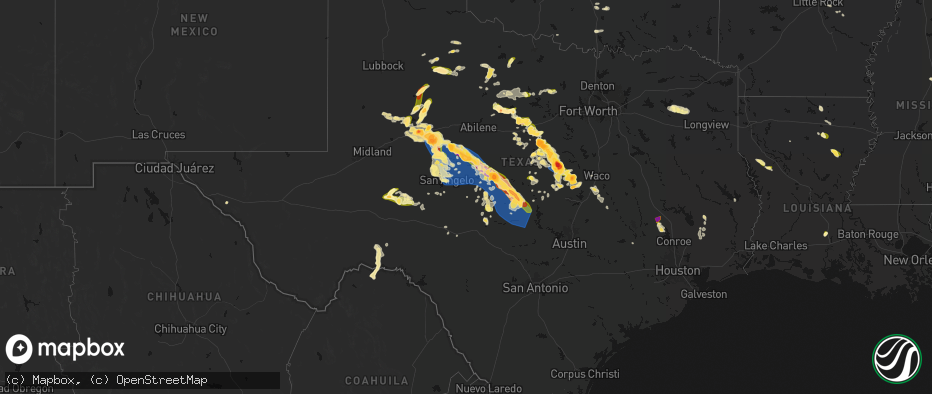
Hail Map in Texas on May 10, 2026
The weather event in Texas on May 10, 2026 includes Hail and Wind maps. 6 states and 361 cities were impacted and suffered possible damage. The total estimated number of properties impacted is 64,251.
Hail
Wind
64,251
Estimated number of impacted properties by a 1.00" hail or larger19,531
Estimated number of impacted properties by a 1.75" hail or larger11,316
Estimated number of impacted properties by a 2.50" hail or largerStorm reports in Texas
Texas
| Date | Description |
|---|---|
| 05/10/20266:55 PM CDT | A local report indicates 67 MPH wind near 3 NNE Brady |
| 05/10/20266:51 PM CDT | Emergency manager reported quarter size |
| 05/10/20266:50 PM CDT | 2 inch diameter tree limbs snapped by high winds. |
| 05/10/20266:42 PM CDT | Report from mping: tennis ball |
| 05/10/20266:41 PM CDT | Delayed report. A large amount of quarter sized hail reported north of goldthwaite near cr 100. Damaged a garden. |
| 05/10/20266:38 PM CDT | Report from mping: hen egg |
| 05/10/20266:37 PM CDT | Report from mping: golf ball |
| 05/10/20266:31 PM CDT | A local report indicates 59 MPH wind near 3 ENE Shields |
| 05/10/20266:29 PM CDT | A local report indicates 1.00 inch wind near 6 S Barnhart |
| 05/10/20266:24 PM CDT | Broken power poles on coke street in hamilton. |
| 05/10/20266:22 PM CDT | Facebook report of baseball size hail on cr 414. |
| 05/10/20266:20 PM CDT | Media chaser measured 4 inch diameter hail just east of hwy 22 and cr 224 intersection. |
| 05/10/20266:20 PM CDT | Corrects previous hail report from 9 wsw cranfills gap. Media chaser measured 4.5 inch diameter hail just east of hwy 22 and cr 224 intersection. |
| 05/10/20266:15 PM CDT | Awos station kmnz hamilton muni. |
| 05/10/20266:15 PM CDT | Report from mping...ping pong ball 1.50 in. |
| 05/10/20266:13 PM CDT | Photo showed 2 inch diameter hail in lanham. |
| 05/10/20266:09 PM CDT | A local report indicates 67 MPH wind near 3 WNW Doole |
| 05/10/20266:00 PM CDT | A local report indicates 1.75 inch wind near 5 W Valera |
| 05/10/20265:50 PM CDT | A local report indicates 1.50 inch wind near Talpa |
| 05/10/20265:45 PM CDT | Delayed report. Hamilton vfd reports baseball sized hail 4 miles north of hamilton on hwy 281. |
| 05/10/20265:45 PM CDT | A local report indicates 1.00 inch wind near 2 S San Angelo |
| 05/10/20265:44 PM CDT | Report from mping: quarter |
| 05/10/20265:40 PM CDT | Report from mping: quarter |
| 05/10/20265:30 PM CDT | Delayed report. Facebook video of quarter sized hail in gustine. |
| 05/10/20265:30 PM CDT | Wind damage to krun radio station building. |
| 05/10/20265:28 PM CDT | A local report indicates 75 MPH wind near 2 N Ballinger |
| 05/10/20265:25 PM CDT | Ping pong ball size hail at fm 1744 and cr 125. |
| 05/10/20265:20 PM CDT | Report from mping: baseball+ |
| 05/10/20265:15 PM CDT | Facebook photo showed ping pong ball size hail east of comanche. |
| 05/10/20265:15 PM CDT | Large tree limb snapped. |
| 05/10/20265:09 PM CDT | Report from mping...quarter 1.00 in. |
| 05/10/20265:03 PM CDT | A local report indicates 1.75 inch wind near 4 ESE Wilmeth |
| 05/10/20264:58 PM CDT | Report from mping...half dollar 1.25 in. |
| 05/10/20264:50 PM CDT | Facebook report of golf ball size hail in proctor. |
| 05/10/20264:40 PM CDT | Golfball size hail reported in dublin. |
| 05/10/20264:35 PM CDT | Several reports of hail up to baseball size in dublin. |
| 05/10/20264:32 PM CDT | Several additional reports and photos of tennis ball size hail in dublin. |
| 05/10/20264:30 PM CDT | Report from mping...hen egg 2.25 in. |
| 05/10/20264:28 PM CDT | Report from mping: quarter |
| 05/10/20264:28 PM CDT | Facebook photo showed tennis ball size hail fell on cr 344 northwest of dublin. |
| 05/10/20264:24 PM CDT | Report from mping: quarter |
| 05/10/20264:20 PM CDT | Delayed report. Public report relayed to broadcast media of hailstones next to a quarter for comparison. Estimated size was near two inches in diameter. The core of the |
| 05/10/20264:18 PM CDT | A local report indicates 1.50 inch wind near 4 WNW Robert Lee |
| 05/10/20264:14 PM CDT | A local report indicates 2.75 inch wind near Blackwell |
| 05/10/20264:09 PM CDT | A local report indicates 60 MPH wind near Robert Lee |
| 05/10/20263:50 PM CDT | Delayed report. Desdemona fire reports multiple large tree limbs of 6 to 8 inches in diameter snapped and broken northeast of the town. |
| 05/10/20263:40 PM CDT | Facebook report of hail larger than ping pong size on cr 118 north of ranger. |
| 05/10/20263:30 PM CDT | Multiple mping reports of tennis to baseball size hail along tx hwy 208 10 miles nw of silver. |
| 05/10/20263:29 PM CDT | [landspout] gustnado reported by storm chaser via social media near the intersection of hwy 208 and cr 337 southeast of colorado city. Gustnado was persistent for at l |
| 05/10/20263:12 PM CDT | Trained spotter report on x showed hail stones around golf ball size just south of breckenridge. Time estimated by radar. |
| 05/10/20263:11 PM CDT | [landspout] corrects previous landspout report from 14 sse colorado city. Gustnado reported by storm chaser via social media near the intersection of hwy 208 and cr 33 |
| 05/10/20263:06 PM CDT | Facebook report of between ping pong and golf ball sized hail on the southwest side of the lake. Time estimated by radar. |
| 05/10/20263:04 PM CDT | Report of 1 inch hail from mping. |
| 05/10/20262:49 PM CDT | Report via social media north of colorado city. Time was estimated by radar. |
| 05/10/20262:47 PM CDT | Report from mping: ping pong ball |
| 05/10/20262:43 PM CDT | A local report indicates 1.75 inch wind near 3 ENE Albany |
| 05/10/20262:40 PM CDT | Report of ping pong ball size hail on the northeast side of snyder. Time was estimated by radar. |
| 05/10/20262:40 PM CDT | Corrects previous hail report from 1 nne snyder. Report of ping pong ball size hail on the northeast side of snyder. Time was estimated by radar. |
| 05/10/20262:39 PM CDT | Social media report of golf ball to hen egg size hail over westbrook. Time was estimated by approximation of occurrence and by radar. |
| 05/10/20262:38 PM CDT | Report from mping: quarter |
| 05/10/20262:37 PM CDT | Delayed public report relayed by media of golf ball size hail from the west side of snyder. Time was estimated by radar. |
| 05/10/20262:32 PM CDT | A tree was downed onto a house on fm 49 just west of pecan road. No injuries. |
| 05/10/20262:28 PM CDT | Multiple trees were downed near the intersection of fm 1002 and fm 49 near the upshur/wood county line. |
| 05/10/20262:28 PM CDT | Quarter size hail fell at the intersection of of fm 1002 and fm 49 near the upshur/wood county line. |
| 05/10/20262:20 PM CDT | A tree was downed near the intersection of highway 154 and cr 3978. |
| 05/10/20262:19 PM CDT | Report from mping: ping pong ball |
| 05/10/20262:18 PM CDT | Report of a tree down near 304 private rd 7976 in wood county... Tx. |
| 05/10/20262:17 PM CDT | Quarter size hail fell in the holly lake ranch community. |
| 05/10/20261:56 PM CDT | Social media report of trees down near 180 county road 3269. |
| 05/10/20261:56 PM CDT | A chicken truck was blown over in hainesville. |
| 05/10/20261:53 PM CDT | Quarter size hail fell in quitman for 5 minutes. Report from social media. |
| 05/10/20262:07 AM CDT | A local report indicates 84 MPH wind near 1 ENE Cc Nas |
| 05/10/20262:04 AM CDT | Asos station krkp rockport. |
| 05/10/20262:03 AM CDT | County dispatch reported that fire crews were working to clear a high concentration of fallen trees along fm 149 and jackson road in montgomery county. Time of damaged |
| 05/10/20261:56 AM CDT | Damage to apartment buildings with siding ripped off the side. |
| 05/10/20261:56 AM CDT | Awos station kngp c. Christi nas. |
| 05/10/20261:56 AM CDT | Mesonet station xlag laguna shores. |
| 05/10/202612:30 AM CDT | Damage to power poles in the city and numerous trees down within the city and county. |
| 05/10/202612:24 AM CDT | Trained spotter reported nickel and quarter size hail near brenham... Tx. |
| 05/10/202612:10 AM CDT | Mesonet station tw102 pawnee ranch. |
| 05/09/202611:44 PM CDT | Trees reported down by law enforcement near the intersection of hwy 36 n and christmas rd. |
| 05/09/202611:05 PM CDT | A tin outbuilding was destroyed. |
| 05/09/202610:25 PM CDT | Isolated reports of downed trees and signage around bastrop. Time estimated via radar. |
| 05/09/202610:25 PM CDT | Delayed report. Social media report of half dollar sized hail and strong winds near rockdale. |
| 05/09/202610:15 PM CDT | Large snapped tree limbs reported near frost bank center. Time estimated via radar. |
| 05/09/202610:14 PM CDT | Delayed report. Large tree down near cr 104 in the leona area. |
| 05/09/202610:14 PM CDT | Location correction. Delayed report. Large tree down near cr 104 in the leona area. |
| 05/09/202610:10 PM CDT | Video on x of an awning over a deck blown down. Time estimated from radar. |
| 05/09/202610:05 PM CDT | Peak gust occurred before rain. Time estimated via radar. |
| 05/09/202610:01 PM CDT | Corrects previous non-tstm wnd gst report to tstm wnd gst from 2 wnw hondo. Asos station khdo south tx rgnl arpt at hondo. |
| 05/09/202610:00 PM CDT | Powerlines reported down across the austin metro area. Over 18...000 customers reported without power. |
| 05/09/202610:00 PM CDT | Corrects previous non-tstm wnd gst report to tstm wnd gst from 8 nne dhanis. Mesonet station ea084 parkers recharge dam. |
| 05/09/20269:54 PM CDT | Corrects previous non-tstm wnd gst report to tstm wnd gst from 2 sw bergstrom international airport. Asos station kaus austin-bergstrom intl arpt. |
| 05/09/20269:54 PM CDT | Corrects previous non-tstm wnd gst report to tstm wnd gst from 2 sw bergstrom internat. Asos station kaus austin-bergstrom intl arpt. |
| 05/09/20269:50 PM CDT | Photo received thru social media of a large snapped tree limb. Time estimated via radar. |
| 05/09/20269:50 PM CDT | Several pictures of downed medium to large tree limbs throughout portions of south austin. Time estimated via radar. |
| 05/09/20269:41 PM CDT | Delayed report. Social media report of ping pong sized hail at the fm 2184 and hwy 190 bridge in rogers. |
| 05/09/20269:30 PM CDT | Scattered reports of downed trees and snapped tree limbs... Including some on power lines... Across north austin. Time estimated via radar. |
| 05/09/20269:27 PM CDT | Few social media pictures of medium to large sized diameter tree limbs down in steiner ranch area. Time estimated via radar. |
| 05/09/20269:17 PM CDT | A trained spotter reported golf ball size hail through mping. The same spotter called to report potentially larger hail that was unsafe to retrieve and measure before s |
| 05/09/20269:16 PM CDT | Corrects previous non-tstm wnd gst report to tstm wnd gst from 1 sse serenada. Awos station kgtu georgetown municipal airport. |
| 05/09/20268:59 PM CDT | Report of quarter sized hail on state highway 195 south of florence and north of sun city. |
| 05/09/20268:58 PM CDT | Quarter size hail was reported along i-45 near exit 136 off spur 67. |
| 05/09/20268:56 PM CDT | Report of 1 inch hail in burnet via trained spotter. |
| 05/09/20268:37 PM CDT | Social media picture of quarter size hail in buchanan dam. Time estimated via radar. |
| 05/09/20268:35 PM CDT | Report with picture on social media of 1.5 inch hail south of lake buchanan. |
| 05/09/20268:20 PM CDT | Hail ranging from 1/4 inch to 1 inch lasting for 5 to 7 minutes. |
| 05/09/20268:15 PM CDT | Facebook photo showed half dollar size hail in mcgregor. |
| 05/09/20268:12 PM CDT | Quarter size hail reported on the south side of mcgregor. |
| 05/09/20268:01 PM CDT | Report from mping: golf ball |
| 05/09/20267:58 PM CDT | Hail... Ranging from half dollar to golf ball size... Fell over birdwell rd north of wesley grove. It was reported that hail fell for approximately 45 minutes in this a |
| 05/09/20267:58 PM CDT | Report from mping: golf ball |
| 05/09/20267:57 PM CDT | A local report indicates 1.75 inch wind near Cherokee |
| 05/09/20267:42 PM CDT | Report from mping...half dollar 1.25 in. |
| 05/09/20267:36 PM CDT | Tennis ball size hail reported in flat. |
| 05/09/20267:28 PM CDT | Tennis ball size hail reported. |
| 05/09/20267:25 PM CDT | A local report indicates 1.75 inch wind near Richland Springs |
| 05/09/20267:21 PM CDT | Report from mping: quarter |
| 05/09/20267:09 PM CDT | Quarter size hail reported in arnett. |
Cities Impacted by Hail Map on May 10, 2026
- Follett, TX
- Darrouzett, TX
- Sulphur, OK
- Roff, OK
- Wynnewood, OK
- Pauls Valley, OK
- Davis, OK
- Ardmore, OK
- Waurika, OK
- Paducah, TX
- Lone Oak, TX
- Point, TX
- Seymour, TX
- Holliday, TX
- Colorado City, TX
- Westbrook, TX
- Quitman, TX
- Alba, TX
- Mineola, TX
- Ackerly, TX
- Lamesa, TX
- Ira, TX
- Hawkins, TX
- Albany, TX
- Snyder, TX
- Winnsboro, TX
- Hector, AR
- Jerusalem, AR
- Coahoma, TX
- Dickens, TX
- Scotland, AR
- Gail, TX
- Big Sandy, TX
- Port Orange, FL
- Daytona Beach, FL
- Mayflower, AR
- Loraine, TX
- Gilmer, TX
- Big Spring, TX
- Ranger, TX
- Breckenridge, TX
- Cisco, TX
- Cleveland, AR
- Moran, TX
- Center Ridge, AR
- Hattieville, AR
- New Smyrna Beach, FL
- Eastland, TX
- Damascus, AR
- Greenbrier, AR
- Converse, LA
- Roscoe, TX
- Desdemona, TX
- Pleasant Hill, LA
- Maryneal, TX
- Sebastian, FL
- Vero Beach, FL
- De Leon, TX
- Gorman, TX
- Silverton, TX
- Enola, AR
- Mcadoo, TX
- Robert Lee, TX
- Fluvanna, TX
- Blackwell, TX
- Mingus, TX
- Carrollton, TX
- Dublin, TX
- Vaiden, MS
- Big Lake, TX
- Romance, AR
- Mount Vernon, AR
- Banks, AR
- Belmont, LA
- Stephenville, TX
- Bronte, TX
- Marthaville, LA
- Dryden, TX
- Justiceburg, TX
- Munday, TX
- Wingate, TX
- Many, LA
- Robeline, LA
- Weinert, TX
- Spur, TX
- Mims, FL
- Throckmorton, TX
- Marion, LA
- Haskell, TX
- Midkiff, TX
- Winters, TX
- Natchitoches, LA
- Goree, TX
- Rising Star, TX
- Carbon, TX
- Strawn, TX
- Carlton, TX
- Carlsbad, TX
- Norton, TX
- Hico, TX
- Sterlington, LA
- Farmerville, LA
- Comstock, TX
- Comanche, TX
- Ethel, MS
- Ballinger, TX
- San Angelo, TX
- McCool, MS
- Talpa, TX
- Goodfellow Afb, TX
- Miles, TX
- West Monroe, LA
- Woodson, TX
- Monroe, LA
- Scott, AR
- Ozona, TX
- Columbia, LA
- Barnhart, TX
- Patrick Afb, FL
- Hamilton, TX
- Gustine, TX
- Preston, MS
- Philadelphia, MS
- Graham, TX
- Newcastle, TX
- Lonoke, AR
- Voss, TX
- Jacksboro, TX
- Perrin, TX
- England, AR
- Humnoke, AR
- Mereta, TX
- Coleman, TX
- Rowena, TX
- Paint Rock, TX
- Valera, TX
- Millersview, TX
- Wall, TX
- Gouldbusk, TX
- Eola, TX
- Eden, TX
- Woodway, TX
- Waco, TX
- Cleveland, TX
- Humphrey, AR
- Wabbaseka, AR
- Pottsville, TX
- Bryson, TX
- Doole, TX
- Melvin, TX
- Lohn, TX
- Rockwood, TX
- Winnsboro, LA
- Jonesboro, TX
- Fort Necessity, LA
- Graford, TX
- Mullin, TX
- Christoval, TX
- Goldthwaite, TX
- Kilmichael, MS
- Kosciusko, MS
- Cameron, TX
- Santa Anna, TX
- Brady, TX
- Rochelle, TX
- Purmela, TX
- Harrisonburg, LA
- Sierra Blanca, TX
- Carencro, LA
- Sunset, LA
- Church Point, LA
- Mertzon, TX
- Saline, LA
- Opelousas, LA
- Gatesville, TX
- Shepherd, TX
- Livingston, TX
- Rio Grande City, TX
- Sullivan City, TX
- Grulla, TX
- Enterprise, LA
- Valley Mills, TX
- Menard, TX
- Rosebud, TX
- Montgomery, TX
- Brookesmith, TX
- Decatur, MS
- Chunky, MS
- Hickory, MS
- Richland Springs, TX
- Mission, TX
- Evant, TX
- Eldorado, TX
- Lampasas, TX
- Louisville, MS
- San Saba, TX
- Mason, TX
- Fredonia, TX
- Voca, TX
- Meridian, MS
- Hext, TX
- Oglesby, TX
- Lott, TX
- Brenham, TX
- Lometa, TX
- Troy, TX
- Cherokee, TX
- Pontotoc, TX
- Art, TX
- Valley Spring, TX
- Edinburg, TX
- Eddy, TX
- Chilton, TX
- Richards, TX
- Enterprise, MS
- London, TX
- Copperas Cove, TX
- Sonora, TX
- Moody, TX
- Llano, TX
- Castell, TX
- McGregor, TX
- Bruceville, TX
- Huntsville, TX
- Junction, TX
- Lorena, TX
- Jasper, TX
- Tow, TX
- Bluffton, TX
- Bedias, TX
- Buchanan Dam, TX
- Hebbronville, TX
- Fort Hood, TX
- Holland, TX
- Chester, TX
- Quitman, MS
- Kempner, TX
- Rocksprings, TX
- Salado, TX
- Corrigan, TX
- Kaplan, LA
- Crawford, TX
- Burnet, TX
- Bertram, TX
- Florence, TX
- Georgetown, TX
- Belton, TX
- Burton, TX
- Midway, TX
- Madisonville, TX
- Sidon, MS
- Greenwood, MS
- Quemado, TX
- Liberty Hill, TX
- Kingsland, TX
- Rogers, TX
- Stonewall, MS
- Hunt, TX
- Temple, TX
- Goodrich, TX
- Mountain Home, TX
- Uvalde, TX
- Ledbetter, TX
- North Zulch, TX
- Lincoln, TX
- Doddsville, MS
- Giddings, TX
- Sunflower, MS
- Bartlett, TX
- Anderson, TX
- Blanco, TX
- Granger, TX
- Paige, TX
- Normangee, TX
- Lexington, TX
- Sabinal, TX
- Schlater, MS
- Buckholts, TX
- La Pryor, TX
- Hondo, TX
- Centerville, TX
- Leona, TX
- Crystal City, TX
- Knippa, TX
- Taylor, TX
- Bandera, TX
- Thorndale, TX
- Itta Bena, MS
- Austin, TX
- Del Valle, TX
- Navasota, TX
- Winona, MS
- Rockdale, TX
- Manor, TX
- Batesville, TX
- Elgin, TX
- San Antonio, TX
- Deridder, LA
- Leesville, LA
- Davilla, TX
- Smithville, TX
- Eagle Pass, TX
- Carmine, TX
- Pitkin, LA
- El Indio, TX
- Big Wells, TX
- Carrizo Springs, TX
- Dilley, TX
- Cotulla, TX
- Asherton, TX
- Ackerman, MS
- Bleiblerville, TX
- Bellville, TX
- Chappell Hill, TX
- Mount Olive, MS
- Collins, MS
- George West, TX
- Beeville, TX
- Karnes City, TX
- Skidmore, TX
- Falls City, TX
- Tynan, TX
- Kenedy, TX
- Whitsett, TX
- Campbellton, TX
- Odem, TX
- Hobson, TX
- Three Rivers, TX
- Goliad, TX
- Sinton, TX
- Mathis, TX
- Woodsboro, TX
- Washington, TX
- Lovelady, TX
- Iola, TX
- Tivoli, TX
- Rockport, TX
- Aransas Pass, TX
- Ingleside, TX
- Port Aransas, TX
- Taft, TX
- Bayside, TX
- Gregory, TX
- Corpus Christi, TX
- Portland, TX
- Fulton, TX
- Conroe, TX
- Port O'Connor, TX
- Matagorda, TX
- Downsville, LA
- Choudrant, LA
- D Hanis, TX
- Cedar Creek, TX
- Pflugerville, TX
- Thrall, TX
- Round Rock, TX
- McDade, TX
- Jarrell, TX
- Coupland, TX
- Hutto, TX
- Bastrop, TX


