Hail Map in Mississippi on May 10, 2026
The weather event in Mississippi on May 10, 2026 includes Hail and Wind maps. 6 states and 361 cities were impacted and suffered possible damage. The total estimated number of properties impacted is 1,719.
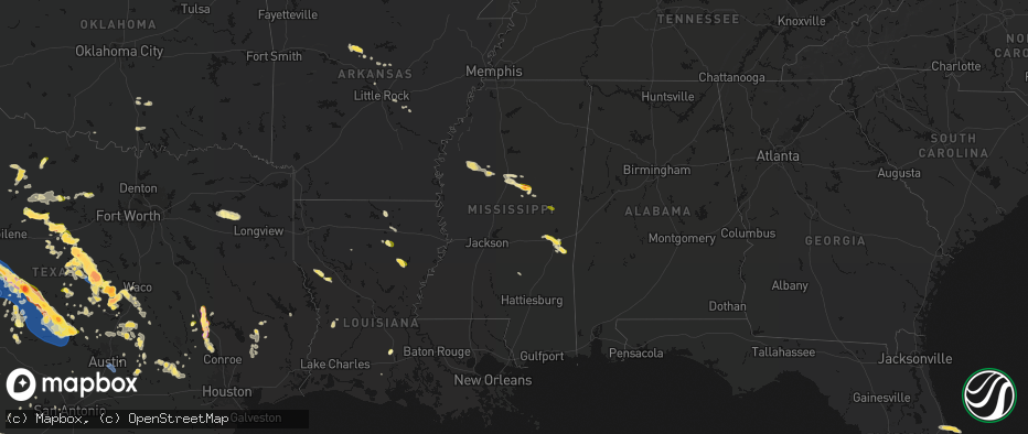
Hail
Wind
1,719
Estimated number of impacted properties by a 1.00" hail or larger262
Estimated number of impacted properties by a 1.75" hail or larger0
Estimated number of impacted properties by a 2.50" hail or largerStorm reports in Mississippi
Mississippi
| Date | Description |
|---|---|
| 05/10/20265:17 PM CDT | Relayed via social media. |
| 05/10/20265:09 PM CDT | Relayed through social media. |
| 05/09/20268:20 PM CDT | Relayed via social media. |
| 05/09/20268:12 PM CDT | Trees were blown down on highway 149. |
| 05/09/20268:00 PM CDT | Video showed hail falling in the enterprise area. |
| 05/09/20267:25 PM CDT | Trees were blown down on highway 80. |
Cities Impacted by Hail Map on May 10, 2026
- Follett, TX
- Darrouzett, TX
- Sulphur, OK
- Roff, OK
- Wynnewood, OK
- Pauls Valley, OK
- Davis, OK
- Ardmore, OK
- Waurika, OK
- Paducah, TX
- Lone Oak, TX
- Point, TX
- Seymour, TX
- Holliday, TX
- Colorado City, TX
- Westbrook, TX
- Quitman, TX
- Alba, TX
- Mineola, TX
- Ackerly, TX
- Lamesa, TX
- Ira, TX
- Hawkins, TX
- Albany, TX
- Snyder, TX
- Winnsboro, TX
- Hector, AR
- Jerusalem, AR
- Coahoma, TX
- Dickens, TX
- Scotland, AR
- Gail, TX
- Big Sandy, TX
- Port Orange, FL
- Daytona Beach, FL
- Mayflower, AR
- Loraine, TX
- Gilmer, TX
- Big Spring, TX
- Ranger, TX
- Breckenridge, TX
- Cisco, TX
- Cleveland, AR
- Moran, TX
- Center Ridge, AR
- Hattieville, AR
- New Smyrna Beach, FL
- Eastland, TX
- Damascus, AR
- Greenbrier, AR
- Converse, LA
- Roscoe, TX
- Desdemona, TX
- Pleasant Hill, LA
- Maryneal, TX
- Sebastian, FL
- Vero Beach, FL
- De Leon, TX
- Gorman, TX
- Silverton, TX
- Enola, AR
- Mcadoo, TX
- Robert Lee, TX
- Fluvanna, TX
- Blackwell, TX
- Mingus, TX
- Carrollton, TX
- Dublin, TX
- Vaiden, MS
- Big Lake, TX
- Romance, AR
- Mount Vernon, AR
- Banks, AR
- Belmont, LA
- Stephenville, TX
- Bronte, TX
- Marthaville, LA
- Dryden, TX
- Justiceburg, TX
- Munday, TX
- Wingate, TX
- Many, LA
- Robeline, LA
- Weinert, TX
- Spur, TX
- Mims, FL
- Throckmorton, TX
- Marion, LA
- Haskell, TX
- Midkiff, TX
- Winters, TX
- Natchitoches, LA
- Goree, TX
- Rising Star, TX
- Carbon, TX
- Strawn, TX
- Carlton, TX
- Carlsbad, TX
- Norton, TX
- Hico, TX
- Sterlington, LA
- Farmerville, LA
- Comstock, TX
- Comanche, TX
- Ethel, MS
- Ballinger, TX
- San Angelo, TX
- McCool, MS
- Talpa, TX
- Goodfellow Afb, TX
- Miles, TX
- West Monroe, LA
- Woodson, TX
- Monroe, LA
- Scott, AR
- Ozona, TX
- Columbia, LA
- Barnhart, TX
- Patrick Afb, FL
- Hamilton, TX
- Gustine, TX
- Preston, MS
- Philadelphia, MS
- Graham, TX
- Newcastle, TX
- Lonoke, AR
- Voss, TX
- Jacksboro, TX
- Perrin, TX
- England, AR
- Humnoke, AR
- Mereta, TX
- Coleman, TX
- Rowena, TX
- Paint Rock, TX
- Valera, TX
- Millersview, TX
- Wall, TX
- Gouldbusk, TX
- Eola, TX
- Eden, TX
- Woodway, TX
- Waco, TX
- Cleveland, TX
- Humphrey, AR
- Wabbaseka, AR
- Pottsville, TX
- Bryson, TX
- Doole, TX
- Melvin, TX
- Lohn, TX
- Rockwood, TX
- Winnsboro, LA
- Jonesboro, TX
- Fort Necessity, LA
- Graford, TX
- Mullin, TX
- Christoval, TX
- Goldthwaite, TX
- Kilmichael, MS
- Kosciusko, MS
- Cameron, TX
- Santa Anna, TX
- Brady, TX
- Rochelle, TX
- Purmela, TX
- Harrisonburg, LA
- Sierra Blanca, TX
- Carencro, LA
- Sunset, LA
- Church Point, LA
- Mertzon, TX
- Saline, LA
- Opelousas, LA
- Gatesville, TX
- Shepherd, TX
- Livingston, TX
- Rio Grande City, TX
- Sullivan City, TX
- Grulla, TX
- Enterprise, LA
- Valley Mills, TX
- Menard, TX
- Rosebud, TX
- Montgomery, TX
- Brookesmith, TX
- Decatur, MS
- Chunky, MS
- Hickory, MS
- Richland Springs, TX
- Mission, TX
- Evant, TX
- Eldorado, TX
- Lampasas, TX
- Louisville, MS
- San Saba, TX
- Mason, TX
- Fredonia, TX
- Voca, TX
- Meridian, MS
- Hext, TX
- Oglesby, TX
- Lott, TX
- Brenham, TX
- Lometa, TX
- Troy, TX
- Cherokee, TX
- Pontotoc, TX
- Art, TX
- Valley Spring, TX
- Edinburg, TX
- Eddy, TX
- Chilton, TX
- Richards, TX
- Enterprise, MS
- London, TX
- Copperas Cove, TX
- Sonora, TX
- Moody, TX
- Llano, TX
- Castell, TX
- McGregor, TX
- Bruceville, TX
- Huntsville, TX
- Junction, TX
- Lorena, TX
- Jasper, TX
- Tow, TX
- Bluffton, TX
- Bedias, TX
- Buchanan Dam, TX
- Hebbronville, TX
- Fort Hood, TX
- Holland, TX
- Chester, TX
- Quitman, MS
- Kempner, TX
- Rocksprings, TX
- Salado, TX
- Corrigan, TX
- Kaplan, LA
- Crawford, TX
- Burnet, TX
- Bertram, TX
- Florence, TX
- Georgetown, TX
- Belton, TX
- Burton, TX
- Midway, TX
- Madisonville, TX
- Sidon, MS
- Greenwood, MS
- Quemado, TX
- Liberty Hill, TX
- Kingsland, TX
- Rogers, TX
- Stonewall, MS
- Hunt, TX
- Temple, TX
- Goodrich, TX
- Mountain Home, TX
- Uvalde, TX
- Ledbetter, TX
- North Zulch, TX
- Lincoln, TX
- Doddsville, MS
- Giddings, TX
- Sunflower, MS
- Bartlett, TX
- Anderson, TX
- Blanco, TX
- Granger, TX
- Paige, TX
- Normangee, TX
- Lexington, TX
- Sabinal, TX
- Schlater, MS
- Buckholts, TX
- La Pryor, TX
- Hondo, TX
- Centerville, TX
- Leona, TX
- Crystal City, TX
- Knippa, TX
- Taylor, TX
- Bandera, TX
- Thorndale, TX
- Itta Bena, MS
- Austin, TX
- Del Valle, TX
- Navasota, TX
- Winona, MS
- Rockdale, TX
- Manor, TX
- Batesville, TX
- Elgin, TX
- San Antonio, TX
- Deridder, LA
- Leesville, LA
- Davilla, TX
- Smithville, TX
- Eagle Pass, TX
- Carmine, TX
- Pitkin, LA
- El Indio, TX
- Big Wells, TX
- Carrizo Springs, TX
- Dilley, TX
- Cotulla, TX
- Asherton, TX
- Ackerman, MS
- Bleiblerville, TX
- Bellville, TX
- Chappell Hill, TX
- Mount Olive, MS
- Collins, MS
- George West, TX
- Beeville, TX
- Karnes City, TX
- Skidmore, TX
- Falls City, TX
- Tynan, TX
- Kenedy, TX
- Whitsett, TX
- Campbellton, TX
- Odem, TX
- Hobson, TX
- Three Rivers, TX
- Goliad, TX
- Sinton, TX
- Mathis, TX
- Woodsboro, TX
- Washington, TX
- Lovelady, TX
- Iola, TX
- Tivoli, TX
- Rockport, TX
- Aransas Pass, TX
- Ingleside, TX
- Port Aransas, TX
- Taft, TX
- Bayside, TX
- Gregory, TX
- Corpus Christi, TX
- Portland, TX
- Fulton, TX
- Conroe, TX
- Port O'Connor, TX
- Matagorda, TX
- Downsville, LA
- Choudrant, LA
- D Hanis, TX
- Cedar Creek, TX
- Pflugerville, TX
- Thrall, TX
- Round Rock, TX
- McDade, TX
- Jarrell, TX
- Coupland, TX
- Hutto, TX
- Bastrop, TX


