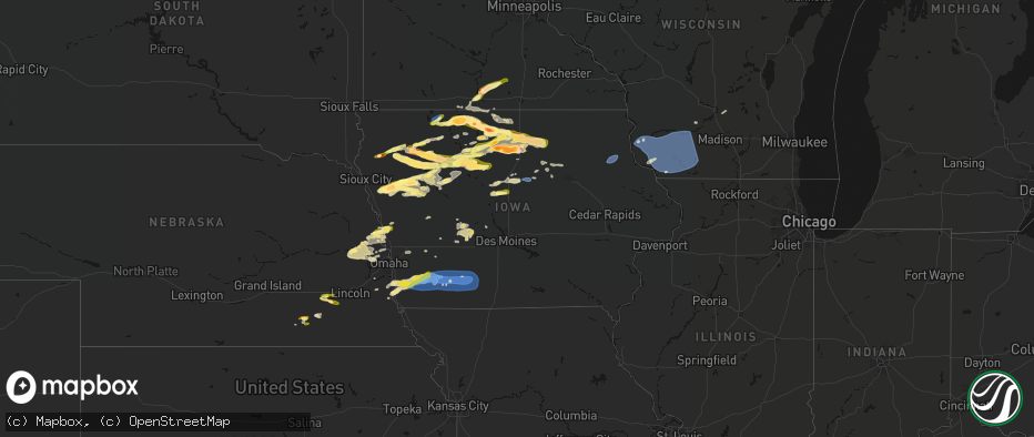
Hail Map in Iowa on May 15, 2026
The weather event in Iowa on May 15, 2026 includes Wind, Hail, and Tornado maps. 9 states and 569 cities were impacted and suffered possible damage. The total estimated number of properties impacted is 71,986.
Wind
Hail
Tornado
71,986
Estimated number of impacted properties by a 1.00" hail or larger18,674
Estimated number of impacted properties by a 1.75" hail or larger2,111
Estimated number of impacted properties by a 2.50" hail or largerStorm reports in Iowa
Iowa
| Date | Description |
|---|---|
| 05/15/20266:58 PM CDT | Awos station krdk red oak airport. |
| 05/15/20266:58 PM CDT | A local report indicates 1.00 inch wind near Woden |
| 05/15/20266:54 PM CDT | Corrects previous tstm wnd dmg report from red oak. Power was reported out in parts of red oak. Power poles down and tree damage. |
| 05/15/20266:54 PM CDT | Power was reported out in parts of red oak. |
| 05/15/20266:43 PM CDT | A local report indicates 1.00 inch wind near Newell |
| 05/15/20266:43 PM CDT | Chaser live stream of one inch hail. Location is approximate. |
| 05/15/20266:40 PM CDT | Tree down at emerson cemetery. |
| 05/15/20266:39 PM CDT | Social media report/photo of a large tree limb down in town. Time estimated based on radar. |
| 05/15/20266:37 PM CDT | Tress downed in imogene. |
| 05/15/20266:32 PM CDT | A local report indicates 1.00 inch wind near 2 SW Correctionville |
| 05/15/20266:25 PM CDT | Small to medium tree down. Time estimated by radar. |
| 05/15/20266:24 PM CDT | A local report indicates 1.75 inch wind near Bancroft |
| 05/15/20266:23 PM CDT | Farm augers blown over and grain wagons moved. |
| 05/15/20266:22 PM CDT | 2 inch hail was reported via social media along with damage to lights fixtures and trees. |
| 05/15/20266:20 PM CDT | Trees down in tabor. |
| 05/15/20266:19 PM CDT | A local report indicates 1.00 inch wind near 3 SSW Anthon |
| 05/15/20266:09 PM CDT | A local report indicates 1.00 inch wind near Armstrong |
| 05/15/20266:04 PM CDT | A local report indicates 1.00 inch wind near 8 N Hornick |
| 05/15/20266:03 PM CDT | A local report indicates 1.75 inch wind near Ringsted |
| 05/15/20266:00 PM CDT | Hail covered the ground... With stones as big as quarters. No wind and a decent amount of rain. |
| 05/15/20265:59 PM CDT | Nickel to quarter size hail. |
| 05/15/20265:24 PM CDT | Brief 60 mph wind gust... Pea hail... And 0.05 inch rain before storm took off to the east. |
| 05/15/20265:20 PM CDT | A local report indicates 1.00 inch wind near 5 WNW Terril |
| 05/14/202610:54 PM CDT | A local report indicates 62 MPH wind near 2 SW Osborne |
| 05/14/202610:49 PM CDT | Personal weather station id kiamcgre12. |
| 05/14/202610:10 PM CDT | Peak gust reported at iowa falls airport. |
| 05/14/20268:45 PM CDT | Report from mping. |
| 05/14/20268:42 PM CDT | Report from mping: half dollar |
| 05/14/20268:39 PM CDT | A local report indicates 1.75 inch wind near 4 NW Thornton |
| 05/14/20268:34 PM CDT | A local report indicates 1.00 inch wind near 5 SSE Ida Grove |
| 05/14/20268:28 PM CDT | Quarter sized hail relayed by email... With attached photo. |
| 05/14/20268:24 PM CDT | In addition to quarter sized hail... There were also some small 1 to 2 inch diameter tree braches knocked down by gusty winds. |
| 05/14/20268:18 PM CDT | Report from mping: ping pong ball |
| 05/14/20268:14 PM CDT | A local report indicates 1.00 inch wind near Garner |
| 05/14/20268:06 PM CDT | Time estimated by radar. |
| 05/14/20268:05 PM CDT | Updated to included windows on house broken. |
| 05/14/20268:05 PM CDT | Corrects previous hail report from 2 wnw meservey. Updated to included windows on house broken. |
| 05/14/20268:05 PM CDT | A local report indicates 1.50 inch wind near 2 WNW Meservey |
| 05/14/20268:03 PM CDT | A local report indicates 1.00 inch wind near 2 WNW Meservey |
| 05/14/20268:00 PM CDT | On i35 near mile marker 186. Time estimated from radar. |
| 05/14/20267:57 PM CDT | Spotter reported ping pong ball size hail. |
| 05/14/20267:50 PM CDT | Report from mping: quarter |
| 05/14/20267:48 PM CDT | Report from mping: half dollar |
| 05/14/20267:47 PM CDT | A local report indicates 1.00 inch wind near 1 WNW Clear Lake |
| 05/14/20267:45 PM CDT | Time estimated by radar. |
| 05/14/20267:35 PM CDT | Report from mping: quarter |
| 05/14/20267:34 PM CDT | Report from mping. |
| 05/14/20267:30 PM CDT | Report from social media. |
| 05/14/20267:25 PM CDT | Windows broken on car. Time estimated by radar. |
| 05/14/20267:22 PM CDT | Hail ranged from 2.25 to 2.5. Time estimated by radar. |
| 05/14/20267:21 PM CDT | A local report indicates 1.00 inch wind near 1 WNW Pocahontas |
| 05/14/20267:20 PM CDT | Medium size tree down. Time estimated by radar. |
| 05/14/20267:08 PM CDT | A local report indicates 1.00 inch wind near 2 W Ida Grove |
| 05/14/20267:08 PM CDT | A local report indicates 1.00 inch wind near 1 E Cushing |
| 05/14/20267:02 PM CDT | Corrects previous tstm wnd gst report from stanton. Public weather station. |
| 05/14/20267:02 PM CDT | Public weather station. |
| 05/14/20267:00 PM CDT | Damage to siding and roofing reported in stanton. |
All States Impacted by Hail Map on May 15, 2026
Cities Impacted by Hail Map on May 15, 2026
- Morton, TX
- Levelland, TX
- Milford, IA
- Estherville, IA
- Terril, IA
- Graettinger, IA
- Wallingford, IA
- Spirit Lake, IA
- Ringsted, IA
- Springfield, NE
- Louisville, NE
- South Bend, NE
- Dolliver, IA
- Armstrong, IA
- Lubbock, TX
- Shallowater, TX
- Murray, NE
- Plattsmouth, NE
- Hornick, IA
- Weeping Water, NE
- Sloan, IA
- Oto, IA
- Smithland, IA
- Nehawka, NE
- Gretna, NE
- Salix, IA
- Climbing Hill, IA
- Moville, IA
- Anthon, IA
- Union, NE
- Nebraska City, NE
- Danbury, IA
- Le Mars, IA
- Fairmont, MN
- Pacific Junction, IA
- Fenton, IA
- Swea City, IA
- Ledyard, IA
- Bancroft, IA
- Rolfe, IA
- Percival, IA
- Glenwood, IA
- Tabor, IA
- Malvern, IA
- Lone Rock, IA
- Titonka, IA
- Burt, IA
- Lakota, IA
- Ottosen, IA
- Bode, IA
- Randolph, IA
- Hastings, IA
- Jolley, IA
- Lytton, IA
- Nemaha, IA
- Storm Lake, IA
- Early, IA
- Thurman, IA
- Correctionville, IA
- Battle Creek, IA
- West Bend, IA
- Blue Earth, MN
- Granada, MN
- Elmwood, NE
- Elmore, MN
- Schaller, IA
- Cushing, IA
- Remsen, IA
- Oyens, IA
- Seminole, TX
- Seagraves, TX
- Denver City, TX
- Plains, TX
- Winnebago, MN
- Delavan, MN
- Idalou, TX
- Imogene, IA
- Emerson, IA
- Red Oak, IA
- Sidney, IA
- Granville, IA
- Marcus, IA
- Shickley, NE
- Wesley, IA
- Woden, IA
- Buffalo Center, IA
- Alta, IA
- Newell, IA
- Holstein, IA
- Paullina, IA
- Easton, MN
- Mapleton, MN
- Minnesota Lake, MN
- Elliott, IA
- Wells, MN
- Essex, IA
- Britt, IA
- Garner, IA
- Ida Grove, IA
- Clarinda, IA
- Villisca, IA
- Stanton, IA
- Strang, NE
- Bruning, NE
- Milligan, NE
- Tobias, NE
- Rockwell City, IA
- Pomeroy, IA
- Cleghorn, IA
- Primghar, IA
- Slaton, TX
- Forest City, IA
- Manson, IA
- Algona, IA
- Ohiowa, NE
- Childress, TX
- Corwith, IA
- Carleton, NE
- Albert City, IA
- Tahoka, TX
- Geary, OK
- Dickens, TX
- Kanawha, IA
- Sutherland, IA
- Sioux Rapids, IA
- Linn Grove, IA
- Royal, IA
- Peterson, IA
- Rembrandt, IA
- Nodaway, IA
- Corning, IA
- Gravity, IA
- Carbon, IA
- Lenox, IA
- New Richland, MN
- Waldorf, MN
- Ventura, IA
- Spur, TX
- Matador, TX
- Aurelia, IA
- Fonda, IA
- Pocahontas, IA
- Palmer, IA
- Crosbyton, TX
- Marathon, IA
- Lu Verne, IA
- Livermore, IA
- Goodell, IA
- Belmond, IA
- Thornton, IA
- Clear Lake, IA
- Cromwell, IA
- Sharpsburg, IA
- Clearfield, IA
- Creston, IA
- Diagonal, IA
- Prescott, IA
- Bridgewater, IA
- Shannon City, IA
- Post, TX
- Fluvanna, TX
- Justiceburg, TX
- Paducah, TX
- Gilmore City, IA
- Greenville, IA
- Spencer, IA
- Galva, IA
- Arthur, IA
- Havelock, IA
- Snyder, TX
- Odonnell, TX
- Dickens, IA
- Canute, OK
- Klemme, IA
- Quanah, TX
- Gail, TX
- Ceylon, MN
- Ruthven, IA
- Rockwell, IA
- Swaledale, IA
- Mason City, IA
- Crystal Lake, IA
- Afton, IA
- Tingley, IA
- Milford, NE
- Beaver Crossing, NE
- Larrabee, IA
- Calumet, IA
- Humboldt, IA
- Clare, IA
- Alexander, IA
- Meservey, IA
- Bradgate, IA
- Kiron, IA
- Friend, NE
- Girard, TX
- Badger, IA
- Odebolt, IA
- Davenport, NE
- Gould, OK
- Sheffield, IA
- Leland, IA
- Latimer, IA
- Cylinder, IA
- Whittemore, IA
- Emmetsburg, IA
- Rockford, IA
- Geneva, NE
- Dougherty, IA
- Thor, IA
- Dakota City, IA
- Rutland, IA
- Goldfield, IA
- Eagle Grove, IA
- Dorchester, NE
- Meriden, IA
- Cherokee, IA
- Sac City, IA
- Jayton, TX
- Bricelyn, MN
- Wall Lake, IA
- Marble Rock, IA
- Laurens, IA
- Joice, IA
- Lake Mills, IA
- Duke, OK
- Crete, NE
- Thompson, IA
- Vincent, IA
- Truesdale, IA
- Hardy, IA
- Renwick, IA
- Charles City, IA
- Varina, IA
- Rule, TX
- Herman, NE
- Tekamah, NE
- Duncombe, IA
- Alden, IA
- Blairsburg, IA
- Williams, IA
- Webster City, IA
- Haskell, TX
- Mondamin, IA
- Little Sioux, IA
- Pisgah, IA
- Minocqua, WI
- Tripoli, WI
- Fremont, NE
- Nickerson, NE
- Arlington, NE
- Ames, NE
- Cedar Bluffs, NE
- North Bend, NE
- Morse Bluff, NE
- Hooper, NE
- Bristow, IA
- Allison, IA
- Moorhead, IA
- Iowa Falls, IA
- Shell Rock, IA
- Blair, NE
- Clarksville, IA
- Modale, IA
- Malmo, NE
- Dumont, IA
- Ackley, IA
- Woodruff, WI
- Logan, IA
- Colon, NE
- Valley, NE
- Janesville, IA
- Waverly, IA
- Parkersburg, IA
- Aplington, IA
- Lake View, IA
- Missouri Valley, IA
- Eagle River, WI
- Yutan, NE
- Mead, NE
- Kennard, NE
- Bennington, NE
- Conover, WI
- Fort Calhoun, NE
- Elkhorn, NE
- Waterloo, NE
- Dike, IA
- Stout, IA
- Washington, NE
- Steamboat Rock, IA
- Strawberry Point, IA
- Volga, IA
- Elkader, IA
- Arlington, IA
- Manilla, IA
- Stratford, IA
- Omaha, NE
- Westside, IA
- Stanhope, IA
- Jewell, IA
- Neola, IA
- Underwood, IA
- Prairie Du Chien, WI
- Manning, IA
- Wauzeka, WI
- Woodman, WI
- Ellsworth, IA
- Minden, IA
- Hancock, IA
- Scranton, IA
- Coon Rapids, IA
- Bayard, IA
- Bagley, IA
- Prairie Du Sac, WI
- Mount Hope, WI
- Boscobel, WI
- Bagley, WI
- Bloomington, WI
- Patch Grove, WI
- Lancaster, WI
- Fennimore, WI
- Stitzer, WI
- Muscoda, WI
- Avoca, WI
- Highland, WI
- Montfort, WI
- Rewey, WI
- Livingston, WI
- Platteville, WI
- Cobb, WI
- Walnut, IA
- Guthrie Center, IA
- Potosi, WI
- Exira, IA
- Dodgeville, WI
- Belmont, WI
- Linden, WI
- Mineral Point, WI
- Spring Green, WI
- Lone Rock, WI
- Panora, IA
- Yale, IA
- Atlantic, IA
- Rio, WI
- Adair, IA
- Bouton, IA
- Cassville, WI
- Benton, WI
- Cuba City, WI
- Shullsburg, WI
- Darlington, WI
- Hazel Green, WI
- Dickeyville, WI
- Linden, IA
- Stuart, IA
- Menlo, IA
- Casey, IA
- Minburn, IA
- Perry, IA
- Hollandale, WI
- Argyle, WI
- Ridgeway, WI
- Blanchardville, WI
- Gratiot, WI
- Arena, WI
- Barneveld, WI
- Verona, WI
- Mount Horeb, WI
- New Glarus, WI
- Black Earth, WI
- Blue Mounds, WI
- Mazomanie, WI
- Belleville, WI
- Cross Plains, WI
- Redfield, IA
- Adel, IA
- Scales Mound, IL
- Apple River, IL
- South Wayne, WI
- Winslow, IL
- Dakota, IL
- Warren, IL
- Browntown, WI
- Monroe, WI
- Monticello, WI
- McConnell, IL
- Woodford, WI
- Orangeville, IL
- Dexter, IA
- Evansville, WI
- Rock City, IL
- South Beloit, IL
- Davis, IL
- Brooklyn, WI
- Juda, WI
- Orfordville, WI
- Beloit, WI
- Albany, WI
- Rockton, IL
- Durand, IL
- Brodhead, WI
- Madison, WI
- Oregon, WI
- Janesville, WI
- Mcfarland, WI
- Stoughton, WI
- Footville, WI
- Edgerton, WI
- Middleton, WI
- Afton, WI
- Van Meter, IA
- Earlham, IA
- Newton, IA
- Winterset, IA
- Campbellsport, WI
- Mayville, WI
- Brownsville, WI
- Lomira, WI
- Theresa, WI
- Monroe, IA
- Kellogg, IA
- Milo, IA
- Pleasantville, IA
- Prole, IA
- Cumming, IA
- Cascade, WI
- Belvidere, IL
- Grinnell, IA
- Lynnville, IA
- Lacona, IA
- Knoxville, IA
- Indianola, IA
- Swan, IA
- Otley, IA
- Peru, IA
- Melcher Dallas, IA
- Round Lake, IL
- Mchenry, IL
- Island Lake, IL
- Wauconda, IL
- Chariton, IA
- Columbia, IA
- Libertyville, IL
- Ottumwa, IA
- Grayslake, IL
- Russell, IA
- Waukegan, IL
- North Chicago, IL
- Agency, IA
- Eldon, IA
- Batavia, IA
- Winfield, IA
- Morning Sun, IA
- Wapello, IA
- Mediapolis, IA
- Yarmouth, IA
- Grand Rapids, MI
- Sperry, IA
- Albia, IA
- Lowell, MI
- Ada, MI
- Oakville, IA
- Belding, MI
- Orleans, MI
- Ionia, MI
- Saranac, MI
- Portland, MI
- Wataga, IL
- Woodhull, IL
- Lynn Center, IL
- Cambridge, IL
- Alpha, IL
- Rio, IL
- Galesburg, IL
- Henderson, IL
- Oneida, IL
- Galva, IL
- Altona, IL
- Kewanee, IL
- Toulon, IL
- Williamsfield, IL
- Knoxville, IL
- Victoria, IL
- Bishop Hill, IL
- La Fayette, IL
- Lyons, MI
- Muir, MI
- Pewamo, MI
- Westphalia, MI
- Speer, IL
- Princeville, IL
- Laura, IL
- Wyoming, IL
- Bradford, IL
- Saint Johns, MI
- Fowler, MI
- Dewitt, MI
- Eagle, MI
- Chillicothe, IL
- Sparland, IL
- Edelstein, IL
- Henry, IL
- Laingsburg, MI
- Bath, MI
- East Peoria, IL
- Lowpoint, IL
- Metamora, IL
- Washburn, IL
- Lacon, IL
- Solsberry, IN
- Bloomfield, IN
- Perry, MI
- Morrice, MI
- Bloomington, IN
- Williamston, MI
- Owosso, MI
- Haslett, MI
- Washington, IL
- Varna, IL
- Eureka, IL
- Roanoke, IL
- Minonk, IL
- Toluca, IL
- La Rose, IL
- Magnolia, IL
- Wenona, IL
- Lostant, IL
- Hennepin, IL
- Oglesby, IL
- Tonica, IL
- McNabb, IL
- Benson, IL
- Rutland, IL
- Streator, IL
- Dana, IL
- Secor, IL
- Fowlerville, MI
- Webberville, MI
- Byron, MI
- Bancroft, MI
- Freedom, IN
- Spencer, IN
- Coal City, IN
- Fenton, MI
- Worthington, IN
- Howell, MI
- Linden, MI
- Nashville, IN
- Columbus, IN
- Ellettsville, IN
- Unionville, IN
- Highland, MI
- Holly, MI
- Davisburg, MI
- White Lake, MI
- Seymour, IN
- Elizabethtown, IN
- Loogootee, IN
- Cannelburg, IN
- Scipio, IN
- North Vernon, IN
- Shoals, IN
- Grammer, IN
- Westport, IN
- Marquette, IA
- Monona, IA
- Farmersburg, IA
- Harpers Ferry, IA
- McGregor, IA


