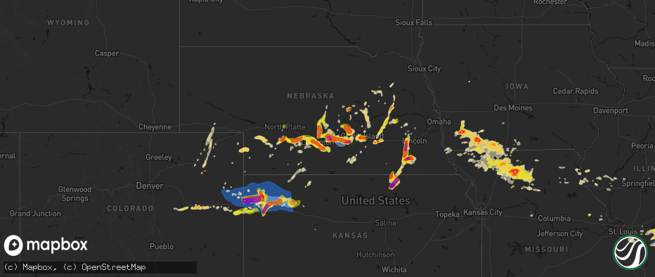
Hail Map on May 16, 2026
The weather event on May 16, 2026 includes Hail, Wind, and Tornado maps. 11 states and 896 cities were impacted and suffered possible damage. The total estimated number of properties impacted is 133,227.
Hail
Wind
Tornado
133,227
Estimated number of impacted properties by a 1.00" hail or larger48,061
Estimated number of impacted properties by a 1.75" hail or larger10,519
Estimated number of impacted properties by a 2.50" hail or largerStates Impacted by Hail Map on May 16, 2026
Storm reports
Kentucky
| Date | Description |
|---|---|
| 05/16/20266:58 PM CDT | Power lines and pole down. Tree down. |
| 05/16/20266:57 PM CDT | Tree fell on power lines. |
| 05/16/20266:49 PM CDT | Tree down. |
| 05/16/20266:46 PM CDT | Trees down. Time estimated from radar. |
| 05/16/20266:36 PM CDT | Trees down. |
| 05/16/20266:25 PM CDT | Tree down in roadway on port royal rd. |
| 05/16/20266:25 PM CDT | Trees down on river road. |
| 05/16/20266:19 PM CDT | Several trees down. |
| 05/16/20266:15 PM CDT | Tree down on power line on w college st. |
| 05/16/20266:00 PM CDT | Tree down in the roadway at ky-146 and webb town rd. |
| 05/16/20265:55 PM CDT | Oldham county mesonet. |
| 05/16/20265:55 PM CDT | Tree down on vehicles on e main st. |
| 05/16/20265:50 PM CDT | Tress down blocking roadway. |
| 05/16/20265:15 PM CDT | Quarter size hail reported throughout downtown louisville. |
| 05/15/20268:00 PM CDT | 2 trees down. |
| 05/15/20267:19 PM CDT | Trees down. |
| 05/15/20267:13 PM CDT | Tree down. |
| 05/15/20267:11 PM CDT | Trees down. |
| 05/15/20267:00 PM CDT | Tree down. |
Indiana
| Date | Description |
|---|---|
| 05/16/20265:45 PM CDT | Large tree down in everman road. |
| 05/16/20265:40 PM CDT | Downed power lines on tunnel mill rd. |
| 05/16/20265:25 PM CDT | Trees down on n mill st in pekin... In. |
| 05/16/20265:00 PM CDT | Corrects previous tstm wnd dmg report from hardinsburg. Trees down on sinking creek ln. |
| 05/16/20265:00 PM CDT | Wires down on e us hwy 150. |
| 05/16/20264:55 PM CDT | Residential report of quarter size hail. |
| 05/16/20263:40 PM CDT | Several public reports of quarter size hail from the crawford county em. |
| 05/16/20262:54 PM CDT | Dime sized hail. |
| 05/16/20262:45 PM CDT | Tree partially in the roadway on s club rd. |
| 05/16/20262:40 PM CDT | Trees down on sinking creek ln. |
Wyoming
| Date | Description |
|---|---|
| 05/16/20265:44 PM CDT | [landspout] a second... Weaker landspout was photographed. Time and location estimated from radar. |
| 05/16/20265:44 PM CDT | [landspout] picture of a landspout about 4 miles west of 85. Location and time estimated from radar. |
Kansas
| Date | Description |
|---|---|
| 05/16/20266:56 PM CDT | Awn; 1730_rd_q. |
| 05/16/20266:56 PM CDT | 12th and broadway; hail photo with a tape measure. |
| 05/16/20266:51 PM CDT | Asos station kgld goodland. |
| 05/16/20266:50 PM CDT | Mesonet station fw1147 16 nw goodland. |
| 05/16/20266:45 PM CDT | Public report of 1.75 inch hail. |
| 05/16/20266:43 PM CDT | Public report with picture of 2.32 inch hail. |
| 05/16/20266:42 PM CDT | Off duty nws employee reports 1 inch hail. |
| 05/16/20266:41 PM CDT | Between an nws employee seeing a ground circulation while a storm chaser noticing a funnel in the same spot from a different angle... Brief tornado east of edson. |
| 05/16/20266:40 PM CDT | F1147; nw sherman. |
| 05/16/20266:40 PM CDT | Mesonet station fw1147 16 nw goodland. |
| 05/16/20266:37 PM CDT | Size estimated... Photo shows hail a little bigger than a quarter. |
| 05/16/20266:34 PM CDT | Social media report of 2 inch hail. |
| 05/16/20266:33 PM CDT | Report from mping: quarter |
| 05/16/20266:32 PM CDT | Sheriff office reported 2 inch hail. |
| 05/16/20266:31 PM CDT | Public report of 2 inch hail in gulick park. |
| 05/16/20266:31 PM CDT | Social media report of a golf ball size hail picture. |
| 05/16/20266:30 PM CDT | Golf ball size; 300 block of sycamore road in goodland. |
| 05/16/20266:30 PM CDT | Public report of 2 inch hail. 11th and sherman. |
| 05/16/20266:29 PM CDT | Social media report 2.05 inch measured hail. |
| 05/16/20266:28 PM CDT | Relayed report from ham operator of measure 2.4 inch hail. Had been laying there a few minutes. |
| 05/16/20266:27 PM CDT | Report from mping: hen egg |
| 05/16/20266:22 PM CDT | Nws employee measured 2 inch hail at the office. |
| 05/16/20266:20 PM CDT | Report from mping: ping pong ball |
| 05/16/20266:19 PM CDT | Report from mping: golf ball |
| 05/16/20266:16 PM CDT | Relayed report of golf ball sized hail. |
| 05/16/20266:09 PM CDT | Golf ball sized hail reported on spotter network. |
| 05/16/20266:08 PM CDT | Spotter network report of one inch hail. |
| 05/16/20265:59 PM CDT | Report from mping: tennis ball |
| 05/16/20265:55 PM CDT | Spotter network report of 2.5 inch hail. |
| 05/16/20265:52 PM CDT | Report of 1.25-2 inch hail. |
| 05/16/20265:30 PM CDT | Social media report with video of golf ball to baseball sized hail. |
| 05/16/20265:30 PM CDT | Delayed report of north of ruleton... Baseball sized hail. |
| 05/16/20265:29 PM CDT | Sherman county dispatch relayed report of one inch hail in kanorado. |
| 05/16/20261:49 AM CDT | Several reports of wires down near and north of highland. Time estimated from radar. |
| 05/16/202612:44 AM CDT | Personal weather station. |
| 05/16/202612:40 AM CDT | Large tree covering road. |
| 05/16/202612:06 AM CDT | Estimated 60 to 80 mph wind gusts in waterville. |
| 05/16/202612:02 AM CDT | Cwop station. |
| 05/15/202611:35 PM CDT | Estimated 90 mph winds with trees and power lines down. |
| 05/15/202611:34 PM CDT | 6-8 inch tree limbs downed. Tree damage widespread across town. Time estimated from radar. |
| 05/15/202611:34 PM CDT | Track and field equipment blown 50 to 100 feet from original location. Time estimated from radar. |
| 05/15/202611:31 PM CDT | Social media post. Also reported 70 mph wind gusts. |
| 05/15/202611:31 PM CDT | Social media post. Also reported quarter size hail. |
| 05/15/202611:22 PM CDT | Report from mping: quarter |
| 05/15/202611:20 PM CDT | A camper was flipped over in the loves gas station parking lot. |
| 05/15/202611:18 PM CDT | Mping report of substantial roof damage. |
| 05/15/202611:18 PM CDT | Asos station kcnk concordia. |
| 05/15/202611:18 PM CDT | Social media report of trees falling onto truck... Cellar door was ripped off of house... And heavy metal chairs were thrown across the yard. Delayed report. |
| 05/15/202611:14 PM CDT | Personal weather station reported. |
| 05/15/202611:05 PM CDT | Personal weather station reported. |
| 05/15/202610:56 PM CDT | A local report indicates 58 MPH wind near Jewell |
| 05/15/202610:54 PM CDT | Personal weather station. |
| 05/15/202610:42 PM CDT | Delayed report with images of damage to a building as well as several fallen tree limbs around town. |
| 05/15/202610:41 PM CDT | A local report indicates 62 MPH wind near 2 N Glen Elder |
| 05/15/202610:15 PM CDT | A local report indicates 60 MPH wind near Smith Center Airport |
| 05/15/202610:10 PM CDT | Picture on social media of a large rest stop sign bent. |
| 05/15/20269:57 PM CDT | A local report indicates 62 MPH wind near 5 NE Codell |
| 05/15/20269:56 PM CDT | A local report indicates 64 MPH wind near 4 W Kirwin |
| 05/15/20269:48 PM CDT | A local report indicates 70 MPH wind near Agra |
| 05/15/20269:45 PM CDT | Estimated from smith county fire. |
| 05/15/20269:43 PM CDT | A local report indicates 62 MPH wind near 2 SSW Kirwin |
| 05/15/20269:41 PM CDT | A local report indicates 61 MPH wind near 1 S Phillipsburg |
| 05/15/20269:40 PM CDT | A local report indicates 69 MPH wind near 5 E Phillipsburg |
| 05/15/20269:19 PM CDT | Khlc asos reported gusted 68 mph. |
| 05/15/20269:10 PM CDT | Mping report. |
| 05/15/20269:08 PM CDT | Asos station khlc hill city. |
| 05/15/20268:46 PM CDT | A local report indicates 1.00 inch wind near 1 W Haddam |
| 05/15/20268:46 PM CDT | Lowrys; awn. |
| 05/15/20268:40 PM CDT | A local report indicates 1.75 inch wind near 1 N Narka |
| 05/15/20268:30 PM CDT | A local report indicates 1.00 inch wind near Morrowville |
| 05/15/20268:28 PM CDT | Spotter network report of 55-60 mph with a few 65 mph gusts. |
| 05/15/20268:27 PM CDT | Weather_station; awn. |
| 05/15/20268:24 PM CDT | Kk1601; awn. |
| 05/15/20268:20 PM CDT | Schippers; awn. |
| 05/15/20268:20 PM CDT | Multiple social media pictures of a fallen dying tree. Roughly 12-15 inch diameter trunk. |
| 05/15/20268:20 PM CDT | Social media report of pictures of 4.5 and 2.0 inch live tree limbs down at the rest stop 10 miles east of brewster. |
| 05/15/20268:16 PM CDT | Dylan; awn. |
| 05/15/20268:15 PM CDT | Awos station koin oberlin. |
| 05/15/20268:09 PM CDT | Weber; awn. |
| 05/15/20267:53 PM CDT | Trained spotter just north of agenda reported 2.5 to 3.0 inch hail. |
| 05/15/20267:49 PM CDT | Spotter network of wind gusts between 80 and 84 with a few reaching 85. |
| 05/15/20267:49 PM CDT | C0352. |
| 05/15/20267:47 PM CDT | Plummer; awn. |
| 05/15/20267:47 PM CDT | Mesonet station fw6347 colby 2e. |
| 05/15/20267:45 PM CDT | F8773. |
| 05/15/20267:44 PM CDT | Summers_646; awn. |
| 05/15/20267:44 PM CDT | My_weather_station; awn. |
| 05/15/20267:43 PM CDT | Ostmeyer_weather_station; awn. |
| 05/15/20267:39 PM CDT | Plummer; awn. |
| 05/15/20267:34 PM CDT | Spotter network report of 1.00 inch hail. |
| 05/15/20267:09 PM CDT | Awn; nw_brewster. |
| 05/15/20267:02 PM CDT | Awn; hendricks_1420_rd_25 in eastern cheyenne county ks. |
| 05/15/20267:00 PM CDT | Spotter report of measured with caliper 2.70 inch hail. |
| 05/15/20267:00 PM CDT | Social media report of picture of a damaged stand-alone shed. |
Missouri
| Date | Description |
|---|---|
| 05/16/20266:55 PM CDT | Social media report. Time estimated from radar. |
| 05/16/20266:43 PM CDT | Nws damage survey team confirmed a shortlived ef0 tornado developed within a severe supercell thunderstorm at 6:43 pm cdt on saturday 5/16/2026. This tornado began appr |
| 05/16/20266:41 PM CDT | Social media report. Time estimated from radar. |
| 05/16/20266:41 PM CDT | Picture of tree damage. |
| 05/16/20266:37 PM CDT | Downed wires and power outages near 60th street. Time estimated from radar. |
| 05/16/20266:34 PM CDT | Mping report of damaged power pole near u.s. Highway 65 and route z. Time estimated from radar. |
| 05/16/20266:31 PM CDT | Report of tree down on hwy dd 1 mile east of shafter mo. Time estimated from radar. |
| 05/16/20266:30 PM CDT | Social media report. Damaged windshields. Time estimated from radar. |
| 05/16/20266:29 PM CDT | Social media report. Time estimated from radar. |
| 05/16/20266:28 PM CDT | Nws damage survey team confirmed an ef1 tornado in northwestern linn county missouri saturday 5/16/2026 north and east of shafter... Mo. This tornado began at 6:28 pm c |
| 05/16/20266:28 PM CDT | Damage to outbuildings along clark drive west of browning mo. Time estimated from radar. |
| 05/16/20266:22 PM CDT | Nws damage survey team confirmed an ef0 tornado in northwest linn county... Mo saturday 5/16/2026. This tornado developed at 6:22 pm between arbor dr. And beacon rd. On |
| 05/16/20266:15 PM CDT | Golf ball to baseball size hail. |
| 05/16/20266:12 PM CDT | 6 inch tree limbs knocked down. |
| 05/16/20265:48 PM CDT | Social media report. Time confirmed from radar. |
| 05/16/20265:48 PM CDT | Downed wires and power outages near 16th street. Time estimated from radar. |
| 05/16/20265:37 PM CDT | Social media report. Severe damage to multiple vehicles. Time estimated from radar. |
| 05/16/20265:37 PM CDT | Social media report. Time estimated from radar. |
| 05/16/20265:36 PM CDT | Downed power lines and power outages near 40th street. Time confirmed from radar. |
| 05/16/20265:33 PM CDT | Social media report. Several trees... Limbs... And wires down in laredo. Time estimated from radar. |
| 05/16/20265:31 PM CDT | A local report indicates 1.50 inch wind near 1 N Trenton |
| 05/16/20265:31 PM CDT | Social media report... Photo... And measurement. Time estimated from radar. |
| 05/16/20265:31 PM CDT | Social media report. Time estimated from radar. |
| 05/16/20265:29 PM CDT | Personal weather station recorded. |
| 05/16/20265:29 PM CDT | Social media report. Time estimated from radar. |
| 05/16/20265:26 PM CDT | A local report indicates 2.00 inch wind near 3 N Trenton |
| 05/16/20265:24 PM CDT | Social media report. Time estimated from radar. |
| 05/16/20265:20 PM CDT | Social media report. Time estimated from radar. |
| 05/16/20265:20 PM CDT | Downed tree at a residence on town and country lane. Time estimated from radar. |
| 05/16/20265:17 PM CDT | Chaser reports baseball size hail south of trenton along hwy 65 via social media. |
| 05/16/20265:16 PM CDT | Social media report. Time estimated from radar. |
| 05/16/20265:14 PM CDT | A local report indicates 1.00 inch wind near 5 E Bethany |
| 05/16/20265:13 PM CDT | Social media report. Time estimated from radar. |
| 05/16/20265:12 PM CDT | Report from mping: quarter |
| 05/16/20265:11 PM CDT | A local report indicates 1.75 inch wind near 2 E Trenton |
| 05/16/20265:11 PM CDT | A local report indicates 1.25 inch wind near 2 ESE Trenton |
| 05/16/20265:02 PM CDT | A local report indicates 1.00 inch wind near 4 E Trenton |
| 05/16/20265:01 PM CDT | A local report indicates 1.50 inch wind near 4 ESE Bethany |
| 05/16/20264:59 PM CDT | Report from mping: half dollar |
| 05/16/20264:59 PM CDT | Power pole leaned over and downed wires near u.s. Highway 65. Time estimated from radar. |
| 05/16/20264:58 PM CDT | A local report indicates 1.25 inch wind near 3 SSE Bethany |
| 05/16/20264:55 PM CDT | Social media report. Time estimated from radar. |
| 05/16/20264:49 PM CDT | A local report indicates 1.00 inch wind near 2 N Bethany |
| 05/16/20264:42 PM CDT | Social media report. Damaged windshield. Time estimated from radar. |
| 05/16/20264:39 PM CDT | A local report indicates 1.00 inch wind near 2 SSW Tindall |
| 05/16/20264:29 PM CDT | Social media report. Time estimated from radar. |
| 05/16/20264:22 PM CDT | Social media report. Time estimated from radar. |
| 05/15/202611:47 PM CDT | Social media report. Time estimated from radar. |
| 05/15/202611:23 PM CDT | Social media report. Time estimated from radar. |
| 05/15/202610:42 PM CDT | Social media report. Minor damage to vehicle. Time estimated from radar. |
| 05/15/202610:34 PM CDT | Time estimated from radar. |
| 05/15/202610:13 PM CDT | Private weather sensor. |
| 05/15/202610:06 PM CDT | Social media report. Time estimated from radar. |
| 05/15/20269:05 PM CDT | Social media report. Time estimated from radar. |
| 05/15/20268:46 PM CDT | Several reports of downed wires north of king city. Time estimated from radar. |
| 05/15/20268:37 PM CDT | Mping report of downed tree limbs near u.s. Highway 136. Time estimated from radar. |
| 05/15/20268:25 PM CDT | A local report indicates 2.00 inch wind near 1 SE Albany |
| 05/15/20268:20 PM CDT | Social media report. Time estimated from radar. |
| 05/15/20268:18 PM CDT | Field flooded from torrential rainfall as well. Time estimated from radar. |
| 05/15/20268:15 PM CDT | Social media report. Time estimated from radar. |
| 05/15/20268:11 PM CDT | A local report indicates 1.00 inch wind near Albany |
| 05/15/20268:10 PM CDT | Downed wires and power outages near routes n and t. Time estimated from radar. |
| 05/15/20268:08 PM CDT | Report from mping: quarter |
| 05/15/20268:03 PM CDT | Social media report. Time estimated from radar. |
| 05/15/20268:01 PM CDT | Social media report. Time estimated from radar. |
| 05/15/20267:59 PM CDT | Social media report. Time estimated from radar. |
| 05/15/20267:59 PM CDT | Large tree limb down near norton street. Time based on social media report and confirmed from radar. |
| 05/15/20267:59 PM CDT | Social media report. Time estimated from radar. |
| 05/15/20267:59 PM CDT | Social media report. Time estimated from radar. |
| 05/15/20267:59 PM CDT | Social media report. Time confirmed from radar. |
| 05/15/20267:58 PM CDT | Video from trained spotter on social media shows severe caliber winds along i-35 near eagleville mo. |
| 05/15/20267:57 PM CDT | Mping reports of trees and limbs down near 140th street. Time estimated from radar. |
| 05/15/20267:57 PM CDT | Social media report. Downed tree limbs in town. Time estimated from radar. |
| 05/15/20267:56 PM CDT | Mping report of damaged power pole near u.s. Highway 136. Time confirmed from radar. |
| 05/15/20267:42 PM CDT | Downed wires near county road 164. Time estimated from radar. |
| 05/15/20267:41 PM CDT | Social media report. Large trees down southeast of hatfield. Time estimated from radar. |
| 05/15/20267:38 PM CDT | Social media report. Time estimated from radar. |
| 05/15/20267:34 PM CDT | Tree uprooted near trenton lower lake. Time estimated from radar and social media report. |
| 05/15/20267:32 PM CDT | Social media report. Time estimated from radar. |
| 05/15/20267:30 PM CDT | Downed wires and power outages near route b. Time estimated from radar. |
| 05/15/20267:22 PM CDT | Social media report. Time estimated from radar. |
| 05/15/20267:20 PM CDT | Social media report. Time estimated from radar. |
| 05/15/20267:16 PM CDT | A local report indicates 1.00 inch wind near Sheridan |
| 05/15/20267:15 PM CDT | Social media video of large tree limb down on mo hwy 139. Time estimated from radar. |
| 05/15/20267:09 PM CDT | Pws measured 58 mph. Pws reported it at 0732... But radar suggests 0709pm cdt is more accurate. |
Iowa
| Date | Description |
|---|---|
| 05/16/20266:28 PM CDT | Report from mping: quarter |
| 05/16/20265:54 PM CDT | A local report indicates a tornado near 1 SE Gravity |
| 05/16/20265:51 PM CDT | Via spotter network. |
| 05/16/20265:46 PM CDT | Via spotter network. |
| 05/16/20265:45 PM CDT | Caliper measured 2.83 hail. Relayed by woi. |
| 05/16/20265:31 PM CDT | Via spotter network. |
| 05/16/20265:24 PM CDT | Storm chaser shared photos of measured two inch hailstones. |
| 05/16/20265:16 PM CDT | Emergency manager reports golf ball size hail just outside of red oak to the southwest. |
| 05/16/20265:16 PM CDT | Report from mping: baseball |
| 05/16/20265:15 PM CDT | Report from mping: quarter |
| 05/16/20265:12 PM CDT | A local report indicates 1.00 inch wind near Red Oak |
| 05/16/20265:10 PM CDT | A local report indicates 1.00 inch wind near 4 N New Market |
| 05/16/20264:51 PM CDT | Member of the public reported hail up to the size of quarters. |
| 05/16/20264:45 PM CDT | Ia dot station. |
| 05/16/20264:33 PM CDT | A local report indicates 1.00 inch wind near 3 S Stanton |
| 05/15/20267:14 PM CDT | A local report indicates 1.75 inch wind near Mount Ayr |
| 05/15/20267:06 PM CDT | A local report indicates 1.00 inch wind near Mount Ayr |
Colorado
| Date | Description |
|---|---|
| 05/16/20266:25 PM CDT | Estimated 65-75 mph wind gust. |
| 05/16/20266:15 PM CDT | Social media report of pictures of a downed dying tree. Additional damage to some vehicles. |
| 05/16/20266:10 PM CDT | Asos station kitr burlington co airport. |
| 05/16/20265:34 PM CDT | Awn; sevenfarms. |
| 05/16/20265:25 PM CDT | Awn; sears_home_weather. |
| 05/16/20265:00 PM CDT | A local report indicates 1.00 inch wind near 4 ESE Fremont Butte |
| 05/16/20264:24 PM CDT | A local report indicates 1.75 inch wind near 2 NW Hugo |
Nebraska
| Date | Description |
|---|---|
| 05/16/20266:58 PM CDT | A local report indicates 1.00 inch wind near 6 W Lexington |
| 05/16/20266:58 PM CDT | A local report indicates 1.00 inch wind near 6 N Riverdale |
| 05/16/20266:56 PM CDT | A local report indicates 60 MPH wind near 1 N Kearney |
| 05/16/20266:52 PM CDT | Large cottonwood limbs down. Estimated 60 to 70 mph wind. |
| 05/16/20266:48 PM CDT | A local report indicates 60 MPH wind near 1 N Kearney |
| 05/16/20266:47 PM CDT | A local report indicates 65 MPH wind near 1 W Kearney |
| 05/16/20266:34 PM CDT | Public report via social media of 2 inch hail. |
| 05/16/20266:26 PM CDT | Social media report of quarter to half dollar sized hail. |
| 05/16/20266:22 PM CDT | Majority of hail was 3/4 inch in size with a few 1 inch sized stones. |
| 05/16/20266:14 PM CDT | Biggest hail was 3 inches. It broke windows. It hailed for at least 30 minutes beginning around 5:45 pm. |
| 05/16/20265:57 PM CDT | A local report indicates 1.75 inch wind near Boelus |
| 05/16/20265:45 PM CDT | A local report indicates 1.50 inch wind near 2 E Henderson |
| 05/16/20265:42 PM CDT | A local report indicates 1.75 inch wind near Henderson |
| 05/16/20265:28 PM CDT | A local report indicates 1.75 inch wind near 1 E Miller |
| 05/16/20265:26 PM CDT | A local report indicates 2.00 inch wind near 6 W Osceola |
| 05/16/20265:20 PM CDT | A local report indicates 1.00 inch wind near 2 E Oconto |
| 05/16/20265:20 PM CDT | A local report indicates 1.00 inch wind near 7 WNW Stromsburg |
| 05/16/20264:52 PM CDT | A local report indicates 1.00 inch wind near North Platte |
| 05/16/20264:52 PM CDT | Actually 1 inch 5/8 inches in diameter. |
| 05/16/20264:50 PM CDT | Hail slightly smaller than golf ball. |
| 05/16/20264:39 PM CDT | A local report indicates 1.00 inch wind near 7 NW Wellfleet |
| 05/16/20264:21 PM CDT | A local report indicates 1.75 inch wind near 5 NW Wellfleet |
| 05/16/202611:52 AM CDT | House lost roof west of crystal springs. |
| 05/16/20261:32 AM CDT | A local report indicates 61 MPH wind near Falls City |
| 05/16/202612:43 AM CDT | A local report indicates 62 MPH wind near Barneston |
| 05/15/202611:54 PM CDT | A local report indicates 88 MPH wind near 2 SW Fairbury |
| 05/15/202611:53 PM CDT | Power is out in fairbury... Trees down... And visibility is 0. |
| 05/15/202611:53 PM CDT | A local report indicates 88 MPH wind near 7 WNW Fairbury |
| 05/15/202611:52 PM CDT | A local report indicates 76 MPH wind near 1 SSE Fairbury |
| 05/15/202611:46 PM CDT | A local report indicates 66 MPH wind near 7 WNW Fairbury |
| 05/15/202611:44 PM CDT | A local report indicates 59 MPH wind near 5 WSW Endicott |
| 05/15/202611:30 PM CDT | A local report indicates 68 MPH wind near 3 E Davenport |
| 05/15/202611:24 PM CDT | A local report indicates 61 MPH wind near 2 SW Carleton |
| 05/15/202611:24 PM CDT | Tree damage in hebron. Time estimated from radar. |
| 05/15/202611:22 PM CDT | A local report indicates 61 MPH wind near 4 ESE Davenport |
| 05/15/202611:22 PM CDT | A local report indicates 68 MPH wind near 3 ENE Davenport |
| 05/15/202611:20 PM CDT | A local report indicates 75 MPH wind near 3 N Chester |
| 05/15/202611:19 PM CDT | Personal weather station. |
| 05/15/202611:18 PM CDT | A local report indicates 71 MPH wind near 3 SW Carleton |
| 05/15/202611:14 PM CDT | A local report indicates 66 MPH wind near 5 NNE Western |
| 05/15/202611:13 PM CDT | A local report indicates 65 MPH wind near 3 SW Davenport |
| 05/15/202611:13 PM CDT | A local report indicates 67 MPH wind near 3 WNW Davenport |
| 05/15/202611:12 PM CDT | A local report indicates 72 MPH wind near 3 ESE Ruskin |
| 05/15/202611:11 PM CDT | A local report indicates 73 MPH wind near 5 NNE Western |
| 05/15/202611:10 PM CDT | A local report indicates 68 MPH wind near 5 W Davenport |
| 05/15/202611:10 PM CDT | Off-duty nws employee reported 7 overturned center pivots between hebron and ruskin. Time estimated from radar. |
| 05/15/202611:06 PM CDT | A local report indicates 72 MPH wind near 1 SSW Oak |
| 05/15/202611:01 PM CDT | Several large trees down in town. |
| 05/15/202611:01 PM CDT | A local report indicates 58 MPH wind near 4 W Oak |
| 05/15/202611:00 PM CDT | Snapped tree branches across the roadway. |
| 05/15/202610:58 PM CDT | Several large trees down in town. |
| 05/15/202610:48 PM CDT | A local report indicates 60 MPH wind near Wood River |
| 05/15/202610:47 PM CDT | A local report indicates 58 MPH wind near 3 SW Davenport |
| 05/15/202610:46 PM CDT | Personal weather station. |
| 05/15/202610:45 PM CDT | A local report indicates 60 MPH wind near 6 NW Nelson |
| 05/15/202610:39 PM CDT | A local report indicates 60 MPH wind near 2 S Milligan |
| 05/15/202610:37 PM CDT | A local report indicates 64 MPH wind near 1 SSE Davenport |
| 05/15/202610:35 PM CDT | A local report indicates 64 MPH wind near 2 SSE Davenport |
| 05/15/202610:31 PM CDT | A local report indicates 63 MPH wind near Kearney Airport |
| 05/15/202610:31 PM CDT | A local report indicates 60 MPH wind near 6 ENE Kearney |
| 05/15/202610:30 PM CDT | A local report indicates 60 MPH wind near 1 W Heartwell |
| 05/15/202610:27 PM CDT | A local report indicates 58 MPH wind near 6 N Exeter |
| 05/15/202610:27 PM CDT | A local report indicates 60 MPH wind near 1 W Heartwell |
| 05/15/202610:25 PM CDT | Personal weather station. |
| 05/15/202610:24 PM CDT | A local report indicates 65 MPH wind near 1 S Ayr |
| 05/15/202610:24 PM CDT | A local report indicates 71 MPH wind near 8 ESE Kearney |
| 05/15/202610:24 PM CDT | A local report indicates 60 MPH wind near 4 NNW Ohiowa |
| 05/15/202610:19 PM CDT | A local report indicates 67 MPH wind near 1 N Minden |
| 05/15/202610:17 PM CDT | Personal weather station. |
| 05/15/202610:17 PM CDT | Multiple reports of significant wind damage in and around minden. Time estimated from radar and nearby observations. |
| 05/15/202610:16 PM CDT | A local report indicates 75 MPH wind near 4 SSE Fairmont |
| 05/15/202610:15 PM CDT | A local report indicates 58 MPH wind near 1 SSE Minden |
| 05/15/202610:15 PM CDT | A local report indicates 69 MPH wind near 3 ENE Geneva |
| 05/15/202610:13 PM CDT | Personal weather station. |
| 05/15/202610:11 PM CDT | A local report indicates 61 MPH wind near 2 WNW Cowles |
| 05/15/202610:10 PM CDT | A local report indicates 63 MPH wind near 2 NNW Holstein |
| 05/15/202610:09 PM CDT | A local report indicates 59 MPH wind near 2 ESE Axtell |
| 05/15/202610:08 PM CDT | A local report indicates 69 MPH wind near 3 ENE Geneva |
| 05/15/202610:06 PM CDT | A local report indicates 58 MPH wind near 3 WNW Hildreth |
| 05/15/202610:05 PM CDT | A local report indicates 63 MPH wind near 3 WSW Fairmont |
| 05/15/202610:04 PM CDT | A local report indicates 59 MPH wind near 3 WNW Riverton |
| 05/15/202610:04 PM CDT | A local report indicates 59 MPH wind near 5 WNW Riverton |
| 05/15/202610:03 PM CDT | A local report indicates 63 MPH wind near 1 SW Axtell |
| 05/15/202610:02 PM CDT | A local report indicates 62 MPH wind near 5 W Geneva |
| 05/15/202610:01 PM CDT | A local report indicates 82 MPH wind near 2 ENE Holdrege |
| 05/15/202610:00 PM CDT | A local report indicates 63 MPH wind near 3 WSW Fairmont |
| 05/15/202610:00 PM CDT | A local report indicates 73 MPH wind near 2 SSE Grafton |
| 05/15/202610:00 PM CDT | A local report indicates 1.00 inch wind near Deweese |
| 05/15/202610:00 PM CDT | A local report indicates 61 MPH wind near 1 W Hildreth |
| 05/15/20269:58 PM CDT | A local report indicates 61 MPH wind near 3 NW Fairmont |
| 05/15/20269:57 PM CDT | A local report indicates 59 MPH wind near 3 N Wilcox |
| 05/15/20269:56 PM CDT | A local report indicates 74 MPH wind near 2 NNW Wilcox |
| 05/15/20269:56 PM CDT | A local report indicates 72 MPH wind near 2 ESE Fairmont |
| 05/15/20269:56 PM CDT | A local report indicates 59 MPH wind near 5 SSE Wilcox |
| 05/15/20269:56 PM CDT | A local report indicates 72 MPH wind near 1.5 ESE Fairmont |
| 05/15/20269:54 PM CDT | A local report indicates 62 MPH wind near 2 NNW Geneva |
| 05/15/20269:52 PM CDT | A local report indicates 73 MPH wind near 2 SSE Grafton |
| 05/15/20269:47 PM CDT | Report from mping: golf ball |
| 05/15/20269:46 PM CDT | A local report indicates 62 MPH wind near 3 WSW Grafton |
| 05/15/20269:46 PM CDT | A local report indicates 62 MPH wind near 4 S Grafton |
| 05/15/20269:45 PM CDT | A local report indicates 58 MPH wind near 1 SSE Harlan County Dam |
| 05/15/20269:39 PM CDT | A local report indicates 60 MPH wind near 3.5 WSW Grafton |
| 05/15/20269:35 PM CDT | A large tree has fallen on a residence in aurora. |
| 05/15/20269:34 PM CDT | A local report indicates 65 MPH wind near 1 SW Henderson |
| 05/15/20269:34 PM CDT | A local report indicates 65 MPH wind near 2 SW Henderson |
| 05/15/20269:33 PM CDT | A local report indicates 69 MPH wind near 2 N Woodruff |
| 05/15/20269:21 PM CDT | Gust occurred at the aurora awos. |
| 05/15/20269:17 PM CDT | A narrow tornado reported. The tornado has since lifted. |
| 05/15/20269:07 PM CDT | A local report indicates 66 MPH wind near 1 SSE Central City |
| 05/15/20268:58 PM CDT | A local report indicates 1.25 inch wind near Malcolm |
| 05/15/20268:56 PM CDT | Public report of golf balls. |
| 05/15/20268:55 PM CDT | A local report indicates 2.75 inch wind near 4 W Plymouth |
| 05/15/20268:55 PM CDT | Report received via nwschat from em. |
| 05/15/20268:54 PM CDT | A local report indicates 1.00 inch wind near Malcolm |
| 05/15/20268:52 PM CDT | Image sent in. |
| 05/15/20268:51 PM CDT | Nws employee. |
| 05/15/20268:50 PM CDT | A local report indicates 1.50 inch wind near Grand Island |
| 05/15/20268:50 PM CDT | A large branch came down and damaged a gutter and a roof in nw grand island. |
| 05/15/20268:49 PM CDT | Spotter report. |
| 05/15/20268:37 PM CDT | Several reports of golfball sized hail. |
| 05/15/20268:36 PM CDT | A local report indicates 1.00 inch wind near Pleasant Dale |
| 05/15/20268:35 PM CDT | Gust occurred at the holdrege airport. |
| 05/15/20268:35 PM CDT | Public report of half dollar sized hail. |
| 05/15/20268:30 PM CDT | Report from mping: golf ball |
| 05/15/20268:27 PM CDT | Report from mping: hen egg+ |
| 05/15/20268:15 PM CDT | Lots of hail on the ground. Measured hail of approx. 2 inches. |
| 05/15/20268:12 PM CDT | Most hail was dime to penny size but a few were larger than quarters. |
| 05/15/20268:11 PM CDT | A local report indicates 1.50 inch wind near 1 E Crete |
| 05/15/20268:03 PM CDT | A local report indicates 2.50 inch wind near De Witt |
| 05/15/20268:00 PM CDT | A local report indicates 2.00 inch wind near Shelton |
| 05/15/20267:57 PM CDT | Report of some quarter size hail mixed with nickels and peas. |
| 05/15/20267:50 PM CDT | A local report indicates 1.00 inch wind near Wilber |
| 05/15/20267:49 PM CDT | A local report indicates 1.50 inch wind near Shelton |
| 05/15/20267:43 PM CDT | A local report indicates 1.75 inch wind near Lexington |
| 05/15/20267:41 PM CDT | A local report indicates 1.00 inch wind near 5 W Lexington |
| 05/15/20267:26 PM CDT | Quarter to half dollar size wind driven hail. |
| 05/15/20267:20 PM CDT | A lot of 1 inch hail along with heavy rain and gusty wind. |
| 05/15/20267:19 PM CDT | At kearney regional airport. |
| 05/15/20267:19 PM CDT | Report from emergency management relayed via nwschat. |
| 05/15/20267:15 PM CDT | Wind damage at highway 10 and avenue n in kearney. There was an overturned pivot and fences blown down. |
| 05/15/20267:11 PM CDT | Power poles and lines down on homes and across roads in the area. |
| 05/15/20267:03 PM CDT | A local report indicates 1.00 inch wind near 5 NNE Kearney |
| 05/15/20267:03 PM CDT | A local report indicates 64 MPH wind near 2 NNE Kearney |
| 05/15/20267:00 PM CDT | A local report indicates 59 MPH wind near Kearney |
Illinois
| Date | Description |
|---|---|
| 05/16/20266:22 PM CDT | Time estimated via radar. Report received via social media. |
| 05/16/20266:13 PM CDT | Tree down on power lines. |
| 05/16/20265:52 PM CDT | Time estimated via radar. Report received via social media. |
| 05/16/20265:32 PM CDT | A local report indicates 60 MPH wind near 2 W Fairfield |
| 05/16/20264:58 PM CDT | Estimated 60 mph at highway 50 and boxwood road. |
| 05/16/20264:54 PM CDT | A local report indicates 1.00 inch wind near 5 SE Dix |
| 05/16/20264:52 PM CDT | Awning to the shell gas station blown over near 12th street. Time estimated by radar. |
| 05/16/20264:48 PM CDT | Marion county em submitted photos of two power poles down across woods lane between east mccord street and meadow lane. Time estimated by radar. |
| 05/16/20264:48 PM CDT | Public post on marion co. Em social media of hail in centralia. |
| 05/16/20264:47 PM CDT | Nws employee estimated 60 mph winds near ashley. |
| 05/16/20264:46 PM CDT | Hail up to the size of golf balls damaged vehicles and roofs along highway 37 between mt vernon and dix. |
| 05/16/20264:18 PM CDT | Powerlines and trees reported down in the area. |
| 05/16/20264:14 PM CDT | Minor shingle damage to the roof of a residence near the boone street road and farthing road intersection. Time estimated by radar. |
| 05/16/20264:14 PM CDT | Reports of powerlines and trees down near oden. Transformer blown near community beach and odin road. |
| 05/16/20262:15 PM CDT | Several reports of dime to nickel sized hail and large branches down in the benton vicinity. |
| 05/16/202612:25 PM CDT | Delayed report. Several photos of damage on west morton ave between us 67 and massey lane. Power poles snapped. Traffic lights downed. Large trees downed. A trailer was |
Ohio
| Date | Description |
|---|---|
| 05/16/20267:32 AM CDT | Quarter to half dollar size hail south of town. |
Cities Impacted by Hail Map on May 16, 2026
- North Vernon, IN
- Urbana, OH
- Saint Paris, OH
- Springfield, OH
- Saint Anthony, IN
- Huntingburg, IN
- Ferdinand, IN
- Celestine, IN
- Holland, IN
- Eckerty, IN
- Dale, IN
- Schnellville, IN
- Birdseye, IN
- Oblong, IL
- Sumner, IL
- Nelson, MO
- Carrollton, KY
- Vevay, IN
- Madison, IN
- Cable, OH
- Saint Meinrad, IN
- Bristow, IN
- Mechanicsburg, OH
- Canaan, IN
- Blackwater, MO
- Bennington, IN
- Taswell, IN
- English, IN
- Flat Rock, IL
- Bridgeport, IL
- Lawrenceville, IL
- Richwood, OH
- Saint Croix, IN
- Petersburg, IN
- Grantsburg, IN
- Rising Sun, IN
- Florence, IN
- Truxton, MO
- Bellflower, MO
- Moscow Mills, MO
- Old Monroe, MO
- Irwin, OH
- Milford Center, OH
- Silex, MO
- Hawk Point, MO
- Troy, MO
- Winfield, MO
- Jasper, IN
- Bethlehem, KY
- Lockport, KY
- Patriot, IN
- Riceville, IA
- Chester, IA
- McIntire, IA
- Stamping Ground, KY
- Ludlow, MO
- Gilliam, MO
- Slater, MO
- Corinth, KY
- Owenton, KY
- Utica, MO
- Hale, MO
- Chillicothe, MO
- Marshall, MO
- Sadieville, KY
- Cynthiana, KY
- Georgetown, KY
- Dawn, MO
- Salisbury, MO
- Sumner, MO
- Rothville, MO
- Mendon, MO
- Brookfield, MO
- Marceline, MO
- Pittsfield, IL
- Mount Olivet, KY
- Carlisle, KY
- Paris, KY
- Brooksville, KY
- Lock Springs, MO
- Meadville, MO
- Payson, IL
- Winchester, IL
- Meredosia, IL
- Arenzville, IL
- Beardstown, IL
- Gallatin, MO
- Shelbyville, MO
- Jamesport, MO
- Virginia, IL
- Laclede, MO
- Liberty, IL
- Sharpsburg, KY
- Emden, MO
- Bluffs, IL
- Ashland, IL
- Clayton, IL
- Linneus, MO
- Chula, MO
- Timewell, IL
- Palmyra, MO
- Trenton, MO
- Purdin, MO
- Hannibal, MO
- Bucklin, MO
- Mount Sterling, IL
- Quincy, IL
- French Lick, IN
- Winigan, MO
- New Boston, MO
- Paoli, IN
- Versailles, IL
- Hardinsburg, IN
- Milltown, IN
- Marengo, IN
- Plainville, IL
- Barry, IL
- Baylis, IL
- Bethel, MO
- Leonard, MO
- Edina, MO
- Taylor, MO
- La Grange, MO
- Knox City, MO
- Monticello, MO
- Canton, MO
- Mendon, IL
- Ursa, IL
- Coatsburg, IL
- Mulkeytown, IL
- Benton, IL
- Mount Carmel, IL
- Ramah, CO
- Hazleton, IN
- Allendale, IL
- Simla, CO
- Browning, MO
- Saint Francisville, IL
- Matheson, CO
- Monroe City, IN
- Decker, IN
- Vincennes, IN
- Smithton, IL
- Freeburg, IL
- Belleville, IL
- Limon, CO
- Aviston, IL
- Trenton, IL
- Wheatland, IN
- Washington, IN
- Jameson, MO
- Highland, IL
- Pocahontas, IL
- Vandalia, IL
- Patoka, IL
- New Athens, IL
- Vernon, IL
- Carlyle, IL
- Mascoutah, IL
- Germantown, IL
- Albers, IL
- Breese, IL
- Alma, IL
- Kinmundy, IL
- Calhan, CO
- Montgomery, IN
- Bruceville, IN
- Bicknell, IN
- Corydon, IN
- Loogootee, IN
- Saint Peter, IL
- Bartelso, IL
- Beckemeyer, IL
- Sandoval, IL
- Odin, IL
- Wellfleet, NE
- Dickens, NE
- Cannelburg, IN
- Hoyleton, IL
- Centralia, IL
- Salem, IL
- Ragsdale, IN
- Farina, IL
- Lanesville, IN
- Georgetown, IN
- Corning, IA
- Prescott, IA
- North Platte, NE
- Aurora, NE
- New Hampton, MO
- Bethany, MO
- Mount Vernon, IL
- Albany, MO
- Walnut Hill, IL
- Kell, IL
- Dix, IL
- Hugo, CO
- Peru, IA
- Lexington, NE
- Eddyville, NE
- Imogene, IA
- Woodlawn, IL
- Coffey, MO
- Central, IN
- Mauckport, IN
- Louisville, IL
- Depauw, IN
- Sumner, NE
- Marysville, OH
- Nashville, IL
- Gilman City, MO
- Villisca, IA
- Stanton, IA
- Bedford, KY
- Plainville, IN
- Battletown, KY
- West Baden Springs, IN
- Truro, IA
- Edgewood, IL
- Genoa, CO
- Pekin, IN
- Palmyra, IN
- Emerson, IA
- Brush, CO
- Red Oak, IA
- Iuka, IL
- Texico, IL
- New Salisbury, IN
- Ramsey, IN
- Clarinda, IA
- Woodstock, OH
- Ashley, IL
- Zanesfield, OH
- West Liberty, OH
- Pattonsburg, MO
- Bluford, IL
- Arriba, CO
- Ravenwood, MO
- Grant, NE
- Spickard, MO
- Martinsville, MO
- Green Castle, MO
- Green City, MO
- Milan, MO
- Akron, CO
- Bradshaw, NE
- Hampton, NE
- Xenia, IL
- Fredericksburg, IN
- Laredo, MO
- New Market, IA
- Elizabeth, IN
- Overton, NE
- Du Bois, IL
- Princeton, MO
- Saint Charles, IA
- Flora, IL
- Richview, IL
- Mason City, NE
- Madrid, NE
- Louisville, KY
- Hillrose, CO
- Clay City, IL
- Henderson, NE
- Nodaway, IA
- Oconto, NE
- New Albany, IN
- Polk, NE
- Maxwell, NE
- Noble, IL
- Maywood, NE
- Keenes, IL
- Benedict, NE
- Johnsonville, IL
- Salem, IN
- Holyoke, CO
- Atwood, CO
- Galt, MO
- Gravity, IA
- West Liberty, IL
- Stanberry, MO
- Newton, IL
- Ingraham, IL
- Olney, IL
- Merino, CO
- Kanorado, KS
- New Middletown, IN
- Ridgeway, MO
- Amherst, CO
- Sims, IL
- Stromsburg, NE
- Osceola, NE
- Clarksville, IN
- Floyds Knobs, IN
- Sailor Springs, IL
- Glenview, KY
- Prospect, KY
- Jeffersonville, IN
- Dundas, IL
- Flagler, CO
- Curtis, NE
- Miller, NE
- Wayne City, IL
- Burlington, CO
- Elliott, IA
- Sterling, CO
- Moorefield, NE
- Brady, NE
- Ravenna, NE
- Shelton, NE
- Humphreys, MO
- Broken Bow, NE
- Elm Creek, NE
- Amherst, NE
- Champion, NE
- Iliff, CO
- Griswold, IA
- Lenox, IA
- Sharpsburg, IA
- Bedford, IA
- Joes, CO
- Cairo, NE
- Farnam, NE
- Elsie, NE
- Buckner, KY
- Crestwood, KY
- La Grange, KY
- Claremont, IL
- Sellersburg, IN
- Fairfield, IL
- Geff, IL
- Kirk, CO
- Seibert, CO
- Creston, IA
- Masonic Home, KY
- Goshen, KY
- Ansley, NE
- Fleming, CO
- Lineville, IA
- Boelus, NE
- Rockville, NE
- Simpsonville, KY
- Fisherville, KY
- Finchville, KY
- Golden Gate, IL
- Clearfield, IA
- Goodland, KS
- Vona, CO
- York, NE
- Peetz, CO
- Padroni, CO
- Gothenburg, NE
- Silver Creek, NE
- Wheeling, MO
- Pewee Valley, KY
- Barnhill, IL
- Cainsville, MO
- Columbus, NE
- Shelby, NE
- Wallace, NE
- Cozad, NE
- Winona, KS
- Ellery, IL
- Albion, IL
- Carmi, IL
- Grayville, IL
- Burnt Prairie, IL
- Stratton, CO
- Browns, IL
- Corydon, IA
- Allerton, IA
- Bethune, CO
- Essex, IA
- Humeston, IA
- Eminence, KY
- Garden Grove, IA
- Pleasanton, NE
- Loup City, NE
- Litchfield, NE
- Smithfield, KY
- Edson, KS
- Idalia, CO
- Willow Island, NE
- Saint Francis, KS
- Wray, CO
- Pleasureville, KY
- Central City, NE
- Archer, NE
- Chapman, NE
- Platte Center, NE
- Crossville, IL
- Owensville, IN
- Griffin, IN
- Diagonal, IA
- Colby, KS
- Sidney, NE
- Duncan, NE
- Monroe, NE
- Benton, IA
- Blockton, IA
- Brewster, KS
- Levant, KS
- McDonald, KS
- Bird City, KS
- Scotia, NE
- Ord, NE
- Frankfort, KY
- Venango, NE
- Palmer, NE
- New Harmony, IN
- Westerville, NE
- Riverdale, NE
- Kearney, NE
- Hopkins, MO
- Immokalee, FL
- Poseyville, IN
- Arapahoe, CO
- Wallace, KS
- Weskan, KS
- Imperial, NE
- Humphrey, NE
- Creston, NE
- Comstock, NE
- North Loup, NE
- Mount Ayr, IA
- Redding, IA
- Lake Panasoffkee, FL
- Wolbach, NE
- Greeley, NE
- Elmo, MO
- Braddyville, IA
- Clearmont, MO
- Sheridan, MO
- Eustis, NE
- Fullerton, NE
- Kellerton, IA
- Plymouth, NE
- Jansen, NE
- Beatrice, NE
- De Witt, NE
- Sharon Springs, KS
- Gibbon, NE
- Newman Grove, NE
- Belgrade, NE
- Cedar Rapids, NE
- Hayes Center, NE
- Stanton, NE
- Madison, NE
- Hatfield, MO
- Grant City, MO
- Rising City, NE
- Elwood, NE
- Worth, MO
- Arcadia, NE
- Lamoni, IA
- Eagleville, MO
- Elgin, NE
- Swanton, NE
- Agenda, KS
- Clyde, KS
- Gem, KS
- Rexford, KS
- Ashton, NE
- Rock Port, MO
- Gentry, MO
- Stockville, NE
- Denver, MO
- Parnell, MO
- Mercer, MO
- Davis City, IA
- Blythedale, MO
- Branford, FL
- Bell, FL
- Breda, IA
- Maryville, MO
- Pickering, MO
- Atwood, KS
- Oakley, KS
- Monument, KS
- Smithfield, NE
- Wood River, NE
- Wilber, NE
- Hallam, NE
- Crete, NE
- Clatonia, NE
- Burlington Junction, MO
- Labelle, FL
- Moore Haven, FL
- Oakdale, NE
- Petersburg, NE
- Cuba, KS
- Clifton, KS
- Tilden, NE
- Meadow Grove, NE
- Primrose, NE
- Hamburg, IA
- Dwight, NE
- Ulysses, NE
- Bellwood, NE
- Haddam, KS
- David City, NE
- Elba, NE
- Hoxie, KS
- Bertrand, NE
- Albion, NE
- Skidmore, MO
- Oberlin, KS
- Palisade, NE
- Belleville, KS
- Clyde, MO
- Brainard, NE
- Norfolk, NE
- Selden, KS
- Grainfield, KS
- Grinnell, KS
- Loomis, NE
- Alda, NE
- McCook, NE
- Morrowville, KS
- Conception Junction, MO
- Pickrell, NE
- Denton, NE
- Mahaska, KS
- Shenandoah, IA
- Grand Island, NE
- Guilford, MO
- Barnard, MO
- Lindsay, NE
- Brownell, KS
- Campbell, NE
- Bladen, NE
- Doniphan, NE
- Darlington, MO
- Cortland, NE
- McFall, MO
- Milford, NE
- Pleasant Dale, NE
- Lincoln, NE
- King City, MO
- Conception, MO
- Indianola, NE
- Danbury, NE
- Lebanon, NE
- Wilsonville, NE
- Roseland, NE
- Holstein, NE
- Holdrege, NE
- Narka, KS
- Fairbury, NE
- Linn, KS
- Endicott, NE
- Glenvil, NE
- Hastings, NE
- Seward, NE
- Weston, NE
- Pierce, NE
- Hoskins, NE
- Tarkio, MO
- Westboro, MO
- Norton, KS
- Peru, NE
- Giltner, NE
- Phillips, NE
- Reynolds, NE
- Cambridge, NE
- Trumbull, NE
- Malcolm, NE
- Valparaiso, NE
- Morland, KS
- Saint Libory, NE
- Raymond, NE
- Ayr, NE
- Garland, NE
- Hubbell, NE
- Washington, KS
- Wahoo, NE
- Ceresco, NE
- Bartley, NE
- Park, KS
- Quinter, KS
- Collyer, KS
- Wakeeney, KS
- Penokee, KS
- Hill City, KS
- Dresden, KS
- Norcatur, KS
- Arapahoe, NE
- Holbrook, NE
- Almena, KS
- Hendley, NE
- Beaver City, NE
- Oxford, NE
- Stamford, NE
- Edison, NE
- Prairie View, KS
- Orleans, NE
- Long Island, KS
- Phillipsburg, KS
- Lenora, KS
- Funk, NE
- Farragut, IA
- Riverton, IA
- Blue Hill, NE
- Harris, MO
- Filley, NE
- Watson, MO
- Maysville, MO
- Munden, KS
- Marquette, NE
- Waverly, IA
- Tripoli, IA
- Belvidere, NE
- Graham, MO
- Rea, MO
- Sumner, IA
- Tobias, NE
- Western, NE
- Clarks, NE
- Dorchester, NE
- Ashland, NE
- Waverly, NE
- Bee, NE
- Bogue, KS
- Palco, KS
- Damar, KS
- Plainville, KS
- Stockton, KS
- Alma, NE
- Atlanta, NE
- Readlyn, IA
- Denver, IA
- Maitland, MO
- Lawrence, NE
- Minden, NE
- Newtown, MO
- Pollock, MO
- Chester, NE
- Guide Rock, NE
- Deweese, NE
- Fairfield, NE
- Natoma, KS
- Woodston, KS
- Glade, KS
- Agra, KS
- Kensington, KS
- Gaylord, KS
- Republican City, NE
- Kirwin, KS
- Axtell, NE
- Naponee, NE
- Hildreth, NE
- Bloomington, NE
- Wilcox, NE
- Davey, NE
- Sutton, NE
- Ithaca, NE
- Juniata, NE
- Upland, NE
- Hebron, NE
- Yutan, NE
- Adams, NE
- Nelson, NE
- Superior, NE
- Sterling, NE
- Grafton, NE
- Fairmont, NE
- Kenesaw, NE
- Burr, NE
- Douglas, NE
- Waterloo, NE
- Fairfax, MO
- Weatherby, MO
- Fairbank, IA
- Gilead, NE
- Edgar, NE
- Oelwein, IA
- Gretna, NE
- Hazleton, IA
- Cedar, KS
- Athol, KS
- Franklin, NE
- Riverton, NE
- Smith Center, KS
- Heartwell, NE
- McCool Junction, NE
- Hordville, NE
- Oak, NE
- Shickley, NE
- Strang, NE
- Milligan, NE
- Waco, NE
- Bolckow, MO
- Unionville, MO
- Geneva, NE
- Carleton, NE
- Alexandria, NE
- Friend, NE
- Beaver Crossing, NE
- Bruning, NE
- Lebanon, KS
- Red Cloud, NE
- Mankato, KS
- Burr Oak, KS
- Inavale, NE
- Esbon, KS
- Utica, NE
- Gresham, NE
- Staplehurst, NE
- Exeter, NE
- Surprise, NE
- Goehner, NE
- Cordova, NE
- Ohiowa, NE
- Tecumseh, NE
- Blue Springs, NE
- Manchester, IA
- Dundee, IA
- Greenwood, NE
- Davenport, NE
- Jewell, KS
- Inland, NE
- Dyersville, IA
- Earlville, IA
- Greeley, IA
- New Vienna, IA
- Edgewood, IA
- Memphis, NE
- Union Star, MO
- Charlestown, IN
- Westport, KY
- Bethlehem, IN
- Pendleton, KY
- New Washington, IN
- Republic, KS
- Peterson, IA
- Hardy, NE
- Courtland, KS
- Webber, KS
- Deshler, NE
- Sulphur, KY
- Campbellsburg, KY
- New Castle, KY
- Ruskin, NE
- Cook, NE
- Beloit, KS
- Oregon, MO
- Hunter, KS
- Sylvan Grove, KS
- Turners Station, KY
- Sanders, KY
- Worthville, KY
- Ghent, KY
- Glen Elder, KS
- Cawker City, KS
- Randall, KS
- Clay Center, NE
- Harvard, NE
- Concordia, KS
- Norway, KS
- Byron, NE
- Formoso, KS
- Scandia, KS
- Jamestown, KS
- Aurora, KS
- Glasco, KS
- Daykin, NE
- Arbela, MO
- Luray, MO
- Memphis, MO
- Rutledge, MO
- Gorin, MO
- Luxemburg, IA
- Guttenberg, IA
- Ong, NE
- Saronville, NE
- Saint Paul, NE
- Dannebrog, NE
- Palmer, KS
- Morganville, KS
- Green, KS
- Clay Center, KS
- Talmage, NE
- Brock, NE
- Johnson, NE
- Delphos, KS
- Novinger, MO
- Fillmore, MO
- Miltonvale, KS
- Wakefield, KS
- Diller, NE
- Hollenberg, KS
- Steele City, NE
- Hanover, KS
- Greenleaf, KS
- Randolph, KS
- Odell, NE
- Lucerne, MO
- Savannah, MO
- Nebraska City, NE
- Julian, NE
- Leonardville, KS
- Barnes, KS
- Bremen, KS
- Waterville, KS
- Martell, NE
- Rosendale, MO
- Auburn, NE
- Wymore, NE
- Marysville, KS
- Beattie, KS
- Oketo, KS
- Helena, MO
- Roca, NE
- Sprague, NE
- Hickman, NE
- Panama, NE
- Liberty, NE
- Bennet, NE
- Lewiston, NE
- Barneston, NE
- Crab Orchard, NE
- Summerfield, KS
- Firth, NE
- Blue Rapids, KS
- Steinauer, NE
- Home, KS
- Burchard, NE
- Virginia, NE
- Frankfort, KS
- Pawnee City, NE
- Elk Creek, NE
- Westmoreland, KS
- Centralia, KS
- Axtell, KS
- Table Rock, NE
- Onaga, KS
- Vermillion, KS
- Olsburg, KS
- Baileyville, KS
- Bern, KS
- Humboldt, NE
- Du Bois, NE
- Corning, KS
- Goff, KS
- Seneca, KS
- Havensville, KS
- Oneida, KS
- Syracuse, NE
- Sabetha, KS
- Stella, NE
- Nemaha, NE
- Verdon, NE
- Shubert, NE
- Dawson, NE
- Brownville, NE
- Soldier, KS
- Circleville, KS
- Falls City, NE
- Wetmore, KS
- Morrill, KS
- Holton, KS
- Fairview, KS
- Powhattan, KS
- Salem, NE
- Netawaka, KS
- Whiting, KS
- Hiawatha, KS
- White Cloud, KS
- Rulo, NE
- Horton, KS
- Craig, MO
- Effingham, KS
- Highland, KS
- Denton, KS
- Muscotah, KS
- Troy, KS
- Lancaster, KS
- Everest, KS
- Robinson, KS
- Hull, IA
- Rock Valley, IA
- Forest City, MO
- Mound City, MO
- Atchison, KS
- Bendena, KS
- Cummings, KS
- Nortonville, KS
- Valley Falls, KS
- Hershey, NE
- Sutherland, NE
- Paxton, NE
- Columbus, WI
- Fall River, WI
- Rio, WI
- Hazard, NE
- Farwell, NE